
林业科学 ›› 2026, Vol. 62 ›› Issue (6): 236-248.doi: 10.11707/j.1001-7488.LYKX20250770
• 综合评述 • 上一篇
全迎1,邵国凡2,李明泽1,3,*( )
)
收稿日期:2025-12-23
修回日期:2026-04-06
出版日期:2026-06-10
发布日期:2026-06-13
通讯作者:
李明泽
E-mail:mingzelee@nefu.edu.cn
基金资助:
Ying Quan1,Guofan Shao2,Mingze Li1,3,*()
Received:2025-12-23
Revised:2026-04-06
Online:2026-06-10
Published:2026-06-13
Contact:
Mingze Li
E-mail:mingzelee@nefu.edu.cn
摘要:
森林碳储量是陆地生态系统最大且最活跃的碳库,在调节全球碳平衡和减缓气候变化中发挥着至关重要的作用,准确估算并动态监测森林碳储量是深入理解陆地生态系统碳循环过程、助力实现国家“双碳”目标的重要基础。近年来,遥感技术的迅速发展显著提升了大尺度森林碳储量的估算能力;然而,由于我国东北地区森林在林分结构、树种组成、起源和林龄上存在极大空间异质性,碳储量的精确估算仍面临较大挑战。本研究依据233篇中英文文献总结东北地区森林碳储量遥感监测方向的研究工作,并综合REDD+机制确立与《巴黎协定》实施细则等制度节点以及激光雷达全球森林结构观测能力形成与云计算平台普及等关键技术进展,将其发展历程划分为3个阶段:粗分辨率经验估算阶段(2010年以前)、中分辨率机理建模阶段(2011—2018年)以及高分辨率智能估算阶段(2019年至今)。针对各阶段的数据源特征、模型方法和主要成果,进一步分析当前研究存在的关键问题以及未来发展方向。文献分析表明,东北地区森林碳储量遥感监测技术经历了由单一粗分辨率光学遥感数据向高分辨率多模态、多时相、多尺度遥感数据深度融合的演进,同时在估计方法上实现了由经验统计模型向过程模型、再向数据驱动的深度学习模型的持续转变。相关研究显著提升了碳储量估算的精度和时空表达能力,为支撑东北地区森林碳汇能力评估、推进生态安全屏障建设与林业高质量发展提供了重要的科学依据和技术支撑。
中图分类号:
全迎,邵国凡,李明泽. 从经验模型到智能估算:东北森林碳储量遥感监测技术革新路径[J]. 林业科学, 2026, 62(6): 236-248.
Ying Quan,Guofan Shao,Mingze Li. From Empirical Models to Intelligent Estimation: An Innovation Pathway of Remote Sensing Technology in Monitoring Forest Carbon Stocks in Northeast China[J]. Scientia Silvae Sinicae, 2026, 62(6): 236-248.
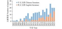
图1
东北森林碳储量遥感估算年度发文数量"
表1
不同研究阶段东北森林碳储量遥感估算的前10位高频关键词"
| 排序 Rank | 2010年以前 Pre-2010 | 2011—2018年 2011—2018 | 2019年至今 Since 2019 |
| 1 | 回归模型 Regression model | 中分辨率成像光谱仪 Moderate resolution imaging spectroradiometer | 随机森林 Random forest |
| 2 | 中分辨率成像光谱仪 Moderate resolution imaging spectroradiometer | 北方生态系统生产力模拟 Boreal ecosystem productivity simulator | 激光雷达 Light detection and ranging |
| 3 | Landsat 卫星专题制图仪 Landsat thematic mapper | 叶面积指数 Leaf area index | 机器学习 Machine learning |
| 4 | 净初级生产力 Net primary productivity | 激光雷达 Light detection and ranging | 集成学习 Ensemble learning |
| 5 | 地形因子 Topographic factors | 碳循环 Carbon cycle | 地基激光雷达 Terrestrial laser scanning |
| 6 | 插值法 Interpolation method | 地球科学激光测高系统 Geoscience laser altimeter system | 哨兵2号多光谱成像仪 Sentinel-2 multispectral instrument |
| 7 | 光能利用率模型 Light use efficiency model | 净初级生产力 Net primary productivity | 地理加权回归 Geographically weighted regression |
| 8 | 神经网络 Neural network | 后向散射系数 Backscattering coefficient | ALOS-2 L波段合成孔径雷达 ALOS-2 L band SAR |
| 9 | 气候变化 Climate change | CASA模型 CASA model | 机载激光雷达 Airborne laser scanning |
| 10 | 模拟 Simulation | 生态过程模型 Ecological process model | 无人机激光雷达 Unmanned aerial vehicle laser scanning |
表2
东北森林碳储量相关遥感估计代表性研究①"
| 年份 Year | 研究区域 Study area | 数据源 Data | 模型 Models | 精度 Accuracy | 面积 Area/ hm2 | 碳密度 Carbon density/ (Mg·hm?2) | 碳储量 Carbon stock/Pg | 参考文献 Reference |
| 1999 | 东北地区 Northeast China | NOAA/AVHRR | 线性回归 Linear regression | R2=0.56 RMSE=13.98 Mg·hm?2 | 4.695× 10⁷ | 46.31 | 2.17 | |
| 2000 | 长白山地区 Changbai Mountains Region | MODIS | 森林景观模型 Forest landscape model | R2=0.89 | 1.571× 10⁷ | 50.29* | 0.79* | |
| 2009 | 凉水自然保护区 Liangshui National Nature Reserve | 航空影像 Aerial image | 支持向量回归 Support vector regression | R2=0.88 rRMSE= 22.31% | 1.14× 10⁴ | 121.34±43.89* | (1.38±0.5) × 10?3* | |
| 2015 | 黑龙江省 Heilongjiang Province | Landsat 8 | 地理加权随机森林 Geographically weighted random forest | R2=0.48 RMSE=59.5 t·hm?2 | 2.012× 10⁷ | 40.88 | 0.82 | |
| 2020 | 东北地区 Northeast China | MODIS、ICESat | 随机森林 Random forest | R2=0.6 RMSE=18.19 Mg·hm?2 | 4.124× 10⁷ | 61.37±15.32 | 2.53±0.63 | |
| 2020 | 吉林省 Jilin Province | ICESat-2、Landsat 8 | 随机森林 Random forest | R2=0.65 | 8.43× 10⁶ | 30.58* | 0.06* | |
| 2022 | 辽宁省 Liaoning Province | UAV-RGB、GEDI、 ICESat-2、Sentinel-2 | 集成学习 Ensemble learning | R2=0.83 rRMSE=8.91% | 5.63× 10⁶ | 17.71* | 0.10±0.04* | |
| 2022 | 大兴安岭 Greater Khingan Mountains | Sentinel-1、Sentinel-2、 PALSAR | XGBoost | R2=0.67 RMSE=22.57 Mg·hm?2 | 6.47× 10⁶ | 39.71* | 0.25* | |
| 2022 | 帽儿山林场 Mao’ershan Forest Farm | Sentinel-1、Sentinel-2 | 回归模型 Regression model | R2=0.66 RMSE=24.95 t·hm?2 | 2.64× 10⁴ | 84.9* | (4.51±0.08)× 10?3* | |
| 2025 | 东北地区 Northeast China | GEDI、Landsat、 ALOS-2 | ForestCarbonNet | R2=0.83 rRMSE=24.02% | 4.145× 10⁷ | 45.39±6.36* | 2.74±0.38* |
| 范文义, 李明泽, 杨金明. 长白山林区森林生物量遥感估测模型. 林业科学, 2011, 47 (10): 16- 20. | |
| Fan W Y, Li M Z, Yang J M. Forest biomass estimation models of remote sensing in Changbai Mountain forests. Scientia Silvae Sinicae, 2011, 47 (10): 16- 20. | |
|
国庆喜, 张 锋. 基于遥感信息估测森林的生物量. 东北林业大学学报, 2003, 31 (2): 13- 16.
doi: 10.3969/j.issn.1000-5382.2003.02.006 |
|
|
Guo Q X, Zhang F. Estimation of forest biomass based on remote sensing. Journal of Northeast Forestry University, 2003, 31 (2): 13- 16.
doi: 10.3969/j.issn.1000-5382.2003.02.006 |
|
| 韩爱惠. 2009. 森林生物量及碳储量遥感监测方法研究. 北京: 北京林业大学. | |
| Han A H. 2009. Study on monitoring method of forest biomass and carbon storage based on remote sensing. Beijing: Beijing Forestry University. [in Chinese] | |
| 郝元朔. 2022. 基于UAV-LiDAR的落叶松人工林生物量多尺度估算. 哈尔滨: 东北林业大学. | |
| Hao Y S. 2022. Mapping larch (Larix olgensis) plantation aboveground biomass using UAV-LiDAR data. Harbin: Northeast Forestry University. [in Chinese] | |
| 黄国胜, 夏朝宗. 基于MODIS的东北地区森林生物量研究. 林业资源管理, 2005 (4): 40- 44. | |
| Huang G S, Xia C Z. MODIS-based estimation of forest biomass in northeast China. Forest Resources Management, 2005 (4): 40- 44. | |
| 雷宇宙, 毛学刚. 结合UAV-LiDAR和Sentinel-2的森林蓄积量估测. 森林工程, 2023, 39 (6): 46- 54. | |
| Lei Y Z, Mao X G. Integrating UAV-LiDAR and sentinel-2 for growing stock volume estimation. Forest Engineering, 2023, 39 (6): 46- 54. | |
| 李明泽. 2010. 东北林区森林生物量遥感估算及分析. 哈尔滨: 东北林业大学. | |
| Li M Z. 2010. Estimation and analysis of forest biomass in northeast forest region using remote sensing technology. Harbin: Northeast Forestry University. [in Chinese] | |
|
李明泽, 王 斌, 范文义, 等. 东北林区净初级生产力及大兴安岭地区林火干扰影响的模拟研究. 植物生态学报, 2015, 39 (4): 322- 332.
doi: 10.17521/cjpe.2015.0031 |
|
|
Li M Z, Wang B, Fan W Y, et al. Simulation of forest net primary production and the effects of fire disturbance in northeast China. Chinese Journal of Plant Ecology, 2015, 39 (4): 322- 332.
doi: 10.17521/cjpe.2015.0031 |
|
|
李明泽, 于欣彤, 高元科, 等. 基于SAR极化分解与Landsat数据的森林生物量遥感估测. 北京林业大学学报, 2018, 40 (2): 1- 10.
doi: 10.13332/j.1000-1522.20170284 |
|
|
Li M Z, Yu X T, Gao Y K, et al. Remote sensing quantification on forest biomass based on SAR polarization decomposition and Landsat data. Journal of Beijing Forestry University, 2018, 40 (2): 1- 10.
doi: 10.13332/j.1000-1522.20170284 |
|
| 梁志锋, 凌飞龙, 汪小钦. L波段SAR与中国东北森林蓄积量的相关性分析. 遥感技术与应用, 2013, 28 (5): 871- 878. | |
| Liang Z F, Ling F L, Wang X Q. Correlation analysis between L-band SAR and forest stem volume in northeast China. Remote Sensing Technology and Application, 2013, 28 (5): 871- 878. | |
|
刘 畅, 李凤日, 贾炜玮, 等. 基于局域统计量的黑龙江省多尺度森林碳储量空间分布变化. 应用生态学报, 2014, 25 (9): 2493- 2500.
doi: 10.13287/j.1001-9332.20140613.005 |
|
|
Liu C, Li F R, Jia W W, et al. Multiple-scale analysis on spatial distribution changes of forest carbon storage in Heilongjiang Province, northeast China based on local statistics. Chinese Journal of Applied Ecology, 2014, 25 (9): 2493- 2500.
doi: 10.13287/j.1001-9332.20140613.005 |
|
| 刘东起, 范文义, 李明泽. 利用小光斑激光雷达估测林分参数和生物量. 东北林业大学学报, 2012, 40 (1): 39- 43. | |
| Liu D Q, Fan W Y, Li M Z. Estimation of forest stand parameters and biomass by small-footprint LiDAR. Journal of Northeast Forestry University, 2012, 40 (1): 39- 43. | |
| 刘浩然, 范伟伟, 徐永胜, 等. 基于无人机激光雷达点云的单木生物量估测. 中南林业科技大学学报, 2021, 41 (8): 92- 99. | |
| Liu H R, Fan W W, Xu Y S, et al. Single tree biomass estimation based on UAV LiDAR point cloud. Journal of Central South University of Forestry & Technology, 2021, 41 (8): 92- 99. | |
| 刘喜云, 孙向阳, 夏朝宗, 等. 东北地区森林植被生产力遥感定量估测. 林业资源管理, 2007 (6): 78- 83. | |
| Liu X Y, Sun X Y, Xia C Z, et al. RS-based monitoring of forest net primary productivity in northeast China. Forest Resources Management, 2007 (6): 78- 83. | |
| 刘正显, 李国春, 罗 琳, 等. 大兴安岭植被净第一性生产力估算与动态分析. 森林工程, 2015, 31 (2): 61- 65, 70. | |
| Liu Z X, Li G C, Luo L, et al. Estimation and dynamic analysis of vegetation net primary productivity in Daxing’an Mountain. Forest Engineering, 2015, 31 (2): 61- 65, 70. | |
|
龙 依, 蒋馥根, 孙 华, 等. 基于HLS数据的森林蓄积量遥感反演. 森林与环境学报, 2021, 41 (6): 620- 628.
doi: 10.13324/j.cnki.jfcf.2021.06.008 |
|
|
Long Y, Jiang F G, Sun H, et al. Remote sensing inversion of forest volume based on HLS data. Journal of Forest and Environment, 2021, 41 (6): 620- 628.
doi: 10.13324/j.cnki.jfcf.2021.06.008 |
|
| 马 野. 2024. 基于深度学习的多尺度森林地上生物量估测及不确定性分析. 哈尔滨: 东北林业大学. | |
| Ma Y. 2024. Multi-scale forest above-ground biomass estimation and uncertainty analysis based on deep learning. Harbin: Northeast Forestry University. [in Chinese] | |
| 毛学刚. 2011. 东北森林碳循环日步长模型与遥感综合应用研究. 哈尔滨: 东北林业大学. | |
| Mao X G. 2011. Study on the model of northeast forest carbon cycle at daily step and the integrated application of remote sensing. Harbin: Northeast Forestry University. [in Chinese] | |
| 毛学刚, 范文义, 李明泽, 等. 2011. 黑龙江长白山森林生物量的时空变化分析. 植物生态学报, 35(4): 371–379. | |
| Mao X G, Fan W Y, Li M Z, et al. 2011. Temporal and spatial analysis of forest biomass in Changbai Mountains, Heilongjiang, China. Chinese Journal of Plant Ecology, 35(4): 371–379. [in Chinese] | |
|
毛学刚, 焦裕欣, 张 颖. 基于BEPS模型的东北三省森林生态系统NPP模拟. 森林工程, 2017a, 33 (1): 22- 27.
doi: 10.3969/j.issn.1006-8023.2017.01.006 |
|
|
Mao X G, Jiao Y X, Zhang Y. NPP simulation of forest ecosystem in three provinces of northeast China based on BEPS model. Forest Engineering, 2017a, 33 (1): 22- 27.
doi: 10.3969/j.issn.1006-8023.2017.01.006 |
|
|
毛学刚, 陈文曲, 胡 屾, 等. 基于生态过程模型的哈尔滨市净初级生产力模拟和分析. 东北林业大学学报, 2017b, 45 (7): 55- 60.
doi: 10.3969/j.issn.1000-5382.2017.07.011 |
|
|
Mao X G, Chen W Q, Hu S, et al. Simulation and analysis of net primary productivity in Harbin with ecological process model. Journal of Northeast Forestry University, 2017b, 45 (7): 55- 60.
doi: 10.3969/j.issn.1000-5382.2017.07.011 |
|
| 梅晓丹. 2017. Biome-BGC模型参数优化及东北森林碳通量估算研究. 哈尔滨: 东北林业大学. | |
| Mei X D. 2017. Study on parameter optimization of Biome-BGC model and estimation of forest carbon flux in northeast China. Harbin: Northeast Forestry University. [in Chinese] | |
| 戚玉娇. 2014. 大兴安岭森林地上碳储量遥感估算与分析. 哈尔滨: 东北林业大学. | |
| Qi Y J. 2014. Estimates of forest above ground carbon storage using remote sensing in Daxing’an Mountains. Harbin: Northeast Forestry University. [in Chinese] | |
|
曲苑婷, 汪 垚, 刘观潮, 等. 基于GLAS激光雷达反演森林生物量. 测绘通报, 2014 (11): 73- 77.
doi: 10.13474/j.cnki.11-2246.2014.0367 |
|
|
Qu Y T, Wang Y, Liu G C, et al. The inversion of forest biomass based on GLAS laser radar. Bulletin of Surveying and Mapping, 2014 (11): 73- 77.
doi: 10.13474/j.cnki.11-2246.2014.0367 |
|
| 全 迎. 2023. 融合无人机LiDAR和高光谱特征的天然次生林树种及林分类型识别. 哈尔滨: 东北林业大学. | |
| Quan Y. 2023. Mapping tree species and forest types in a typical natural secondary forest by fusing UAV-borne LiDAR and hyperspectral features. Harbin: Northeast Forestry University. [in Chinese] | |
|
宋 茜, 范文义. 大兴安岭植被生物量的ALOS PALSAR估算. 应用生态学报, 2011, 22 (2): 303- 308.
doi: 10.13287/j.1001-9332.2011.0074 |
|
|
Song Q, Fan W Y. ALOS PALSAR estimation of vegetation biomass in Daxing’anling region. Chinese Journal of Applied Ecology, 2011, 22 (2): 303- 308.
doi: 10.13287/j.1001-9332.2011.0074 |
|
| 孙维侠, 史学正, 于东升, 等. 我国东北地区土壤有机碳密度和储量的估算研究. 土壤学报, 2004, 41 (2): 298- 300. | |
| Sun W X, Shi X Z, Yu D S, et al. Estimation of soil organic carbon density and storage of northeast China. Acta Pedologica Sinica, 2004, 41 (2): 298- 300. | |
| 孙钰森. 2019a. 基于GWRK模型的帽儿山地区森林碳储量空间分布. 哈尔滨: 东北林业大学. | |
| Sun Y S. 2019. Spatial distribution of forest carbon storage in Mao’ershan region based on GWRK model. Harbin: Northeast Forestry University. [in Chinese] | |
|
孙钰森, 王维芳, 李国春. 基于地理加权回归克里格模型的帽儿山地区森林碳储量空间分布. 应用生态学报, 2019b, 30 (5): 1642- 1650.
doi: 10.13287/j.1001-9332.201905.024 |
|
|
Sun Y S, Wang W F, Li G C. Spatial distribution of forest carbon storage in Mao’ershan region, northeast China based on geographically weighted regression Kriging model. Chinese Journal of Applied Ecology, 2019b, 30 (5): 1642- 1650.
doi: 10.13287/j.1001-9332.201905.024 |
|
| 孙忠秋, 高金萍, 吴发云, 等. 基于机载激光雷达点云和随机森林算法的森林蓄积量估测. 林业科学, 2021, 57 (8): 68- 81. | |
| Sun Z Q, Gao J P, Wu F Y, et al. Estimating forest stock volume via small-footprint LiDAR point cloud data and random forest algorithm. Scientia Silvae Sinicae, 2021, 57 (8): 68- 81. | |
|
王维芳, 吕世颖, 李国春, 等. 黑龙江省植被净第一性生产力动态分析. 东北林业大学学报, 2013, 41 (1): 24- 26.
doi: 10.3969/j.issn.1000-5382.2013.01.007 |
|
|
Wang W F, Lü S Y, Li G C, et al. Dynamic analysis of net primary productivity in Heilongjiang Province, China. Journal of Northeast Forestry University, 2013, 41 (1): 24- 26.
doi: 10.3969/j.issn.1000-5382.2013.01.007 |
|
| 王维芳, 宋丽楠, 隋 欣. 帽儿山林场森林生物量估测及时空动态格局分析. 东北林业大学学报, 2010, 38 (1): 47- 49. | |
| Wang W F, Song L N, Sui X. Estimation of forest biomass and its temporal and spatial distribution patterns in Mao’ershan forest farm, Heilongjiang Province. Journal of Northeast Forestry University, 2010, 38 (1): 47- 49. | |
|
王绪高, 吕晓涛, 郗凤明, 等. 东北陆地生态系统碳汇现状与研究展望. 应用生态学报, 2024, 35 (9): 2322- 2337.
doi: 10.13287/j.1001-9332.202409.006 |
|
|
Wang X G, Lü X T, Xi F M, et al. Current status and research prospects of terrestrial ecosystem carbon sink in northeast China. Chinese Journal of Applied Ecology, 2024, 35 (9): 2322- 2337.
doi: 10.13287/j.1001-9332.202409.006 |
|
|
王 耀, 梁 宇, 刘 波, 等. 东北地区森林地上碳储量动态及固碳潜力预测. 生态学杂志, 2025, 44 (2): 353- 364.
doi: 10.13292/j.1000-4890.202502.038 |
|
|
Wang Y, Liang Y, Liu B, et al. Dynamic assessment and carbon sequestration potential prediction of forest aboveground carbon stock in northeast China. Chinese Journal of Ecology, 2025, 44 (2): 353- 364.
doi: 10.13292/j.1000-4890.202502.038 |
|
|
吴 迪, 范文义. 协同ICESat/GLAS和MISR数据估算小兴安岭地区森林地上生物量. 植物研究, 2015, 35 (3): 397- 405.
doi: 10.7525/j.issn.1673-5102.2015.03.012 |
|
|
Wu D, Fan W Y. Synergistic use of ICESat/GLAS and MISR data for estimating forest aboveground biomass. Bulletin of Botanical Research, 2015, 35 (3): 397- 405.
doi: 10.7525/j.issn.1673-5102.2015.03.012 |
|
|
肖 湘, 王西峰, 范文义, 等. 黑龙江省区小兴安岭森林生态系统碳密度遥感估算. 东北林业大学学报, 2015, 43 (4): 127- 130.
doi: 10.3969/j.issn.1000-5382.2015.04.028 |
|
|
Xiao X, Wang X F, Fan W Y, et al. Forest ecosystem carbon density in Xiaoxing’an Mountains of Heilongjiang Province based on the remote sensing. Journal of Northeast Forestry University, 2015, 43 (4): 127- 130.
doi: 10.3969/j.issn.1000-5382.2015.04.028 |
|
| 邢艳秋. 2005. 基于RS和GIS东北天然林区域森林生物量及碳贮量估测研究. 哈尔滨: 东北林业大学. | |
| Xing Y Q. 2005. Regional forest biomass and carbon storage estimation study for northeast natural forest based on RS and GIS. Harbin: Northeast Forestry University. [in Chinese] | |
| 于 兵. 2010. 大庆地区土地利用/覆被变化对植被和土壤碳氮储量的影响. 哈尔滨: 东北林业大学. | |
| Yu B. 2010. The effect of land use/cover change on vegetation and soil carbon/nitrogen storage in Daqing region. Harbin: Northeast Forestry University. [in Chinese] | |
| 张冬有. 2009. 黑龙江省森林植被净初级生产力遥感估算研究. 北京: 北京林业大学. | |
| Zhang D Y. 2009. Estimation of forest net primary productivity in Heilongjiang Province based on remote sensing. Beijing: Beijing Forestry University. [in Chinese] | |
| 张伟伦, 张延成, 范文义, 等. 干涉水云模型对不同极化方式哨兵数据估测森林生物量的精度比较. 东北林业大学学报, 2020, 48 (11): 27- 32. | |
| Zhang W L, Zhang Y C, Fan W Y, et al. Comparison of biomass accuracy with different polarization data with interferometric water cloud model. Journal of Northeast Forestry University, 2020, 48 (11): 27- 32. | |
| 张元元. 2009. 大兴安岭地区森林生物量遥感模型的研究. 哈尔滨: 东北林业大学. | |
| Zhang Y Y. 2009. The research on the remote sensing model for forest biomass in Daxing’an Mountains. Harbin: Northeast Forestry University. [in Chinese] | |
| 张智洋, 赵颖慧, 甄 贞. 基于LUCC的1986–2022年松花江流域陆地生态系统碳储量动态监测. 植物生态学报, 2024, 48 (10): 1274- 1290. | |
| Zhang Z Y, Zhao Y H, Zhen Z. Dynamic monitoring of carbon storage of the terrestrial ecosystem in Songhua River Basin from 1986 to 2022 based on land use and land cover change. Chinese Journal of Plant Ecology, 2024, 48 (10): 1274- 1290. | |
| 赵国帅, 王军邦, 范文义, 等. 2000—2008年中国东北地区植被净初级生产力的模拟及季节变化. 应用生态学报, 2011, 22 (3): 621- 630. | |
| Zhao G S, Wang J B, Fan W Y, et al. Vegetation net primary productivity in northeast China in 2000—2008: simulation and seasonal change. Chinese Journal of Applied Ecology, 2011, 22 (3): 621- 630. | |
|
赵俊芳, 延晓冬, 贾根锁. 1981—2002年中国东北地区森林生态系统碳储量的模拟. 应用生态学报, 2009, 20 (2): 241- 249.
doi: 10.13287/j.1001-9332.2009.0063 |
|
|
Zhao J F, Yan X D, Jia G S. Simulation of carbon stocks of forest ecosystems in northeast China from 1981 to 2002. Chinese Journal of Applied Ecology, 2009, 20 (2): 241- 249.
doi: 10.13287/j.1001-9332.2009.0063 |
|
|
赵颖慧, 蔡鑫垚, 甄 贞. 基于随机森林偏差校正和多源遥感数据的天然次生林地上生物量估测. 中南林业科技大学学报, 2021, 41 (7): 96- 106, 141.
doi: 10.14067/j.cnki.1673-923x.2021.07.012 |
|
|
Zhao Y H, Cai X Y, Zhen Z. Estimation of aboveground biomass of natural secondary forest based on bias-corrected random forest and multi-source data. Journal of Central South University of Forestry & Technology, 2021, 41 (7): 96- 106, 141.
doi: 10.14067/j.cnki.1673-923x.2021.07.012 |
|
|
赵颖慧, 李思琪, 甄 贞, 等. 黑龙江省黑河地区森林地上生物量和NPP估测及时空格局. 应用生态学报, 2016, 27 (10): 3070- 3080.
doi: 10.13287/j.1001-9332.201610.023 |
|
|
Zhao Y H, Li S Q, Zhen Z, et al. Estimation and spatial-temporal pattern of forest aboveground biomass and NPP in Heihe region, Heilongjiang Province, China. Chinese Journal of Applied Ecology, 2016, 27 (10): 3070- 3080.
doi: 10.13287/j.1001-9332.201610.023 |
|
| 钟 浩. 2024. 联合无人机多源遥感数据单木生物量反演研究. 哈尔滨: 东北林业大学. | |
| Zhong H. 2024. Research on individual tree biomass inversion using multi-source remote sensing data from unmanned aerial vehicles. Harbin: Northeast Forestry University. | |
| 周振宝. 2006. 大兴安岭主要可燃物类型生物量与碳储量的研究. 哈尔滨: 东北林业大学. | |
| Zhou Z B. 2006. Study on biomass and carbon storage of main fuel type in Daxing’anling Mountain. Harbin: Northeast Forestry University. [in Chinese] | |
| 邹为涛. 2024. 面向区域尺度森林植被NPP反演的分布式存储与处理方法研究. 哈尔滨: 东北林业大学. | |
| Zou W T. 2024. Research on distributed storage and processing methods for regional scale forest NPP inversion. Harbin: Northeast Forestry University. [in Chinese] | |
| Albergel E. 2021. Earth observation satellites: Monitoring greenhouse gas emissions under the Paris Agreement. Paris: Sciences Po School of Public Affairs. | |
|
Brede B, Terryn L, Barbier N, et al. Non-destructive estimation of individual tree biomass: Allometric models, terrestrial and UAV laser scanning. Remote Sensing of Environment, 2022, 280, 113180.
doi: 10.1016/j.rse.2022.113180 |
|
|
Canadell J G, Raupach M R. Managing forests for climate change mitigation. Science, 2008, 320 (5882): 1456- 1457.
doi: 10.1126/science.1155458 |
|
|
Chave J, Davies S J, Phillips O L, et al. Ground data are essential for biomass remote sensing missions. Surveys in Geophysics, 2019, 40 (4): 863- 880.
doi: 10.1007/s10712-019-09528-w |
|
|
Chen L F, Gao Y H, Li L, et al. Forest NPP estimation based on MODIS data under cloudless condition. Science in China Series D: Earth Sciences, 2008, 51 (3): 331- 338.
doi: 10.1007/s11430-008-0013-8 |
|
|
Chen L, Ren C Y, Zhang B, et al. Estimation of forest above-ground biomass by geographically weighted regression and machine learning with sentinel imagery. Forests, 2018, 9 (10): 582.
doi: 10.3390/f9100582 |
|
|
Chen L, Wang Y Q, Ren C Y, et al. Assessment of multi-wavelength SAR and multispectral instrument data for forest aboveground biomass mapping using random forest Kriging. Forest Ecology and Management, 2019, 447, 12- 25.
doi: 10.1016/j.foreco.2019.05.057 |
|
|
Chen M J, Qiu X C, Zeng W S, et al. Combining sample plot stratification and machine learning algorithms to improve forest aboveground carbon density estimation in northeast China using airborne LiDAR data. Remote Sensing, 2022, 14 (6): 1477.
doi: 10.3390/rs14061477 |
|
|
Chi H, Sun G Q, Huang J L, et al. Estimation of forest aboveground biomass in Changbai Mountain region using ICESat/GLAS and landsat/TM data. Remote Sensing, 2017, 9 (7): 707.
doi: 10.3390/rs9070707 |
|
|
Coops N C, Irwin L A K, Seely H S, et al. Advances in laser scanning to assess carbon in forests: from ground-based to space-based sensors. Current Forestry Reports, 2025, 11 (1): 11.
doi: 10.1007/s40725-024-00242-4 |
|
|
Dong J R, Kaufmann R K, Myneni R B, et al. Remote sensing estimates of boreal and temperate forest woody biomass: carbon pools, sources, and sinks. Remote Sensing of Environment, 2003, 84 (3): 393- 410.
doi: 10.1016/S0034-4257(02)00130-X |
|
|
Duncanson L, Armston J, Disney M, et al. The importance of consistent global forest aboveground biomass product validation. Surveys in Geophysics, 2019, 40 (4): 979- 999.
doi: 10.1007/s10712-019-09538-8 |
|
|
Fassnacht F E, White J C, Wulder M A, et al. Remote sensing in forestry: current challenges, considerations and directions. Forestry, 2024, 97 (1): 11- 37.
doi: 10.1093/forestry/cpad024 |
|
|
Fu H C, Zhao H Q, Liu G, et al. Forest aboveground carbon storage estimation and uncertainty analysis by coupled multi-source remote sensing data in Liaoning Province. Ecological Indicators, 2025, 176, 113729.
doi: 10.1016/j.ecolind.2025.113729 |
|
|
Fu Y Y, He H S, Hawbaker T J, et al. Evaluating k-nearest neighbor (kNN) imputation models for species-level aboveground forest biomass mapping in northeast China. Remote Sensing, 2019, 11 (17): 2005.
doi: 10.3390/rs11172005 |
|
|
Gao T, Zhu J J, Yan Q L, et al. Mapping growing stock volume and biomass carbon storage of larch plantations in northeast China with L-band ALOS PALSAR backscatter mosaics. International Journal of Remote Sensing, 2018, 39 (22): 7978- 7997.
doi: 10.1080/01431161.2018.1479793 |
|
|
Guan X B, Yang X G, Yu Y, et al. Improved optical phenology estimation contributes to more accurate simulation of forest carbon sink dynamics in northeast China. Ecological Indicators, 2025, 178, 114122.
doi: 10.1016/j.ecolind.2025.114122 |
|
|
Guo Q Y, Du S H, Jiang J B, et al. Combining GEDI and sentinel data to estimate forest canopy mean height and aboveground biomass. Ecological Informatics, 2023, 78, 102348.
doi: 10.1016/j.ecoinf.2023.102348 |
|
|
Hao Y S, Pukkala T, Liu X, et al. Mapping aboveground tree biomass and uncertainty using an upscaling approach: a case study of the larch forests in northeastern China using UAV laser scanning data. ISPRS Journal of Photogrammetry and Remote Sensing, 2026, 231, 595- 607.
doi: 10.1016/j.isprsjprs.2025.11.008 |
|
|
Jiang J, Yu Q Z, Liu Y J, et al. Seasonal variations of canopy spectra and their indications to carbon fluxes in a temperate forest in northeast China. Journal of Applied Remote Sensing, 2022, 16 (4): 048503.
doi: 10.1117/1.jrs.16.048503 |
|
|
Jiang P C, He H, Mao Z K, et al. Canopy properties predominately explain above-ground biomass stock in temperate forests. Journal of Plant Ecology, 2025, 18 (2): rtaf026.
doi: 10.1093/jpe/rtaf026 |
|
|
Jin H, Zhao Y H, Pak U, et al. Assessing the effect of ensemble learning algorithms and validation approach on estimating forest aboveground biomass: a case study of natural secondary forest in northeast China. Geo-spatial Information Science, 2025, 28 (2): 609- 628.
doi: 10.1080/10095020.2024.2311261 |
|
| Li J N, Bao W, Wang X M, et al. Estimating aboveground biomass of boreal forests in northern China using multiple datasets. IEEE Transactions on Geoscience and Remote Sensing, 2024, 62, 4408410. | |
|
Li W, Niu Z, Liang X L, et al. Geostatistical modeling using LiDAR-derived prior knowledge with SPOT-6 data to estimate temperate forest canopy cover and above-ground biomass via stratified random sampling. International Journal of Applied Earth Observation and Geoinformation, 2015, 41, 88- 98.
doi: 10.1016/j.jag.2015.04.020 |
|
|
Liu K L, Wang J D, Zeng W S, et al. Comparison and evaluation of three methods for estimating forest above ground biomass using TM and GLAS data. Remote Sensing, 2017, 9 (4): 341.
doi: 10.3390/rs9040341 |
|
|
Lu D S, Chen Q, Wang G X, et al. A survey of remote sensing-based aboveground biomass estimation methods in forest ecosystems. International Journal of Digital Earth, 2016, 9 (1): 63- 105.
doi: 10.1080/17538947.2014.990526 |
|
|
Lü G T, Wang X Y, Ding X Y, et al. ForestCarbonNet: integrating terrain-corrected GEDI, Landsat, and PALSAR2 for enhanced forest aboveground carbon density estimation. GIScience & Remote Sensing, 2025, 62 (1): 2555024.
doi: 10.1080/15481603.2025.2555024 |
|
|
Lu X M, Zheng G, Miller C, et al. Combining multi-source remotely sensed data and a process-based model for forest aboveground biomass updating. Sensors, 2017, 17 (9): 2062.
doi: 10.3390/s17092062 |
|
|
Luo W X, Kim H S, Zhao X H, et al. New forest biomass carbon stock estimates in northeast Asia based on multisource data. Global Change Biology, 2020, 26 (12): 7045- 7066.
doi: 10.1111/gcb.15376 |
|
|
Ma J, Xiao X M, Qin Y W, et al. Estimating aboveground biomass of broadleaf, needleleaf, and mixed forests in northeastern China through analysis of 25-m ALOS/PALSAR mosaic data. Forest Ecology and Management, 2017, 389, 199- 210.
doi: 10.1016/j.foreco.2016.12.020 |
|
|
Ma Y, Im J, Zhen Z, et al. A framework for upscaling aboveground biomass from an individual tree to landscape level and qualifying the multiscale spatial uncertainties for secondary forests. Geo-Spatial Information Science, 2025, 28 (1): 97- 116.
doi: 10.1080/10095020.2024.2449447 |
|
|
Ma Y, Liu Y T, Wang J Y, et al. Understanding ecosystem services of detailed forest and wetland types using remote sensing and deep learning techniques in northern China. Journal of Environmental Management, 2024, 372, 123410.
doi: 10.1016/j.jenvman.2024.123410 |
|
|
Ma Y, Zhang L J, Im J, et al. Novel features of canopy height distribution for aboveground biomass estimation using machine learning: a case study in natural secondary forests. Remote Sensing, 2023, 15 (18): 4364.
doi: 10.3390/rs15184364 |
|
|
Meng S L, Pang Y, Zhang Z J, et al. Mapping aboveground biomass using texture indices from aerial photos in a temperate forest of northeastern China. Remote Sensing, 2016, 8 (3): 230.
doi: 10.3390/rs8030230 |
|
|
Ni X L, Cao C X, Zhou Y K, et al. Estimation of forest biomass patterns across northeast China based on allometric scale relationship. Forests, 2017, 8 (8): 288.
doi: 10.3390/f8080288 |
|
|
Quegan S, Le Toan T, Chave J, et al. The European Space Agency BIOMASS mission: measuring forest above-ground biomass from space. Remote Sensing of Environment, 2019, 227, 44- 60.
doi: 10.1016/j.rse.2019.03.032 |
|
|
Saatchi S S, Harris N L, Brown S, et al. Benchmark map of forest carbon stocks in tropical regions across three continents. Proceedings of the National Academy of Sciences of the United States of America, 2011, 108 (24): 9899- 9904.
doi: 10.1073/pnas.1019576108 |
|
|
Tan K, Piao S L, Peng C H, et al. Satellite-based estimation of biomass carbon stocks for northeast China’s forests between 1982 and 1999. Forest Ecology and Management, 2007, 240 (1/2/3): 114- 121.
doi: 10.1016/j.foreco.2006.12.018 |
|
| Tang X L, Zhao X, Bai Y F, et al. Carbon pools in China’s terrestrial ecosystems: New estimates based on an intensive field survey. Proceedings of the National Academy of Sciences of the United States of America, 2018, 115 (16): 4021- 4026. | |
|
Wang D J, Xing Y Q, Fu A M, et al. Mapping forest aboveground biomass using multi-source remote sensing data based on the XGBoost algorithm. Forests, 2025, 16 (2): 347.
doi: 10.3390/f16020347 |
|
|
Wang J R, Xiang C Z, Liang A L. Estimation of forest aboveground biomass in China based on GEDI and sentinel-2 data: quantitative analysis of optical remote sensing saturation effect and terrain compensation mechanisms. Remote Sensing, 2025a, 17 (20): 3437.
doi: 10.3390/rs17203437 |
|
|
Wang X C, Shao G F, Chen H, et al. An application of remote sensing data in mapping landscape-level forest biomass for monitoring the effectiveness of forest policies in northeastern China. Environmental Management, 2013, 52 (3): 612- 620.
doi: 10.1007/s00267-013-0089-6 |
|
|
Wang X P, Fang J Y, Zhu B. Forest biomass and root–shoot allocation in northeast China. Forest Ecology and Management, 2008, 255 (12): 4007- 4020.
doi: 10.1016/j.foreco.2008.03.055 |
|
|
Wang X P, Ouyang S, Sun O J, et al. Forest biomass patterns across northeast China are strongly shaped by forest height. Forest Ecology and Management, 2013b, 293, 149- 160.
doi: 10.1016/j.foreco.2013.01.001 |
|
|
Wang Y X, Peng Y N, Hu X D, et al. Fine-resolution forest height estimation by integrating ICESat-2 and landsat 8 OLI data with a spatial downscaling method for aboveground biomass quantification. Forests, 2023, 14 (7): 1414.
doi: 10.3390/f14071414 |
|
|
Wei J, Wu G, Deng H B, et al. Spatial pattern of soil carbon and nutrient storage at the Alpine tundra ecosystem of Changbai Mountain, China. Journal of Forestry Research, 2004, 15 (4): 249- 254.
doi: 10.1007/BF02844947 |
|
|
Wu Z Q, Liu X, Cheng S M, et al. Evaluating the effectiveness of forest type stratification for aboveground biomass inference. International Journal of Applied Earth Observation and Geoinformation, 2025, 143, 104829.
doi: 10.1016/j.jag.2025.104829 |
|
|
Yu Q Z, Wang S Q, Mickler R A, et al. Narrowband bio-indicator monitoring of temperate forest carbon fluxes in northeastern China. Remote Sensing, 2014, 6 (9): 8986- 9013.
doi: 10.3390/rs6098986 |
|
|
Yu Y, Yang X G, Fan W Y. Estimates of forest structure parameters from GLAS data and multi-angle imaging spectrometer data. International Journal of Applied Earth Observation and Geoinformation, 2015, 38, 65- 71.
doi: 10.1016/j.jag.2014.12.013 |
|
|
Zhang D H, Ni H. Inversion of forest biomass based on multi-source remote sensing images. Sensors, 2023a, 23 (23): 9313.
doi: 10.3390/s23239313 |
|
|
Zhang G, Ganguly S, Nemani R R, et al. Estimation of forest aboveground biomass in California using canopy height and leaf area index estimated from satellite data. Remote Sensing of Environment, 2014a, 151, 44- 56.
doi: 10.1016/j.rse.2014.01.025 |
|
| Zhang P, Shao G, Zhao G, et al. China’s forest policy for the 21st century. Science, 2000, 288 (5474): 2135- 2136. | |
|
Zhang Y Z, Li W H, Liang S L. New metrics and the combinations for estimating forest biomass from GLAS data. IEEE Journal of Selected Topics in Applied Earth Observations and Remote Sensing, 2021, 14, 7830- 7839.
doi: 10.1109/JSTARS.2021.3101285 |
|
|
Zhang Y Z, Liang S L, Sun G Q. Forest biomass mapping of northeastern China using GLAS and MODIS data. IEEE Journal of Selected Topics in Applied Earth Observations and Remote Sensing, 2014b, 7 (1): 140- 152.
doi: 10.1109/JSTARS.2013.2256883 |
|
|
Zhang Y Z, Liu J J, Li W H, et al. A proposed ensemble feature selection method for estimating forest aboveground biomass from multiple satellite data. Remote Sensing, 2023b, 15 (4): 1096.
doi: 10.3390/rs15041096 |
|
|
Zhang Y, Wang A Z, Yuan F H, et al. The application of EO-1 Hyperion Hyperspectral data to estimate the GPP of temperate forest in Changbai Mountain, northeast China. Environmental Earth Sciences, 2021b, 80 (9): 353.
doi: 10.1007/s12665-021-09639-x |
|
|
Zhang Z R, Zhao Y T, Zhen Z, et al. Nondestructive individual tree aboveground biomass estimation using a hierarchical Bayesian approach in combination with individual tree competition indices. Plant Phenomics, 2025, 7 (4): 100120.
doi: 10.1016/j.plaphe.2025.100120 |
|
|
Zhao Y T, Im J, Zhen Z, et al. Towards accurate individual tree parameters estimation in dense forest: optimized coarse-to-fine algorithms for registering UAV and terrestrial LiDAR data. GIScience & Remote Sensing, 2023, 60 (1): 2197281.
doi: 10.1080/15481603.2023.2197281 |
|
|
Zhen Z, Li X, Ma Y, et al. A hybrid method for forest aboveground biomass estimation: fusion of individual tree- and area-based approaches over northeast China. GIScience & Remote Sensing, 2025, 62 (1): 2497629.
doi: 10.1080/15481603.2025.2497629 |
|
|
Zhou Y, Wei G R, Wang Y, et al. Estimating regional forest carbon density using remote sensing and geographically weighted random forest models: a case study of mid- to high-latitude forests in China. Forests, 2025, 16 (1): 96.
doi: 10.3390/f16010096 |
| [1] | 田栋元,刘兆刚,姜立春,董灵波. 基于随机森林的大兴安岭中部天然林更新数量影响因素识别[J]. 林业科学, 2026, 62(5): 69-79. |
| [2] | 练一宁,卢昊,淮永建,徐海峰,霍朗宁,王智超. 点云语义引导的无人机激光雷达单木分割与参数估算[J]. 林业科学, 2026, 62(4): 106-117. |
| [3] | 曾伟生,温雪香,付涵,孙乡楠,吕康梅,刘樯漪,王甜. 基于激光雷达的北京市主要林分因子联立模型构建与应用[J]. 林业科学, 2026, 62(4): 68-80. |
| [4] | 范光鹏,许亮亮,蔡会德,徐占勇,孟想,邵亚奎,卢峰. 基于地基激光雷达点云的桉树单木参数提取与地上碳储量测定[J]. 林业科学, 2026, 62(3): 88-99. |
| [5] | 胡兴涛,张怀清,杨廷栋,张京,蒋娴. 林草元宇宙技术体系与应用[J]. 林业科学, 2026, 62(2): 25-39. |
| [6] | 姚宗琦,雷令婷,柴国奇,霍朗宁,田昕,张晓丽. 星载多光谱与SAR协同的地表覆盖及森林类型变化检测方法[J]. 林业科学, 2026, 62(2): 160-172. |
| [7] | 竹万宽,王志超,许宇星,黄润霞,陶怡,钟源源,杜阿朋. 基于机器学习算法的雷州半岛桉树复层混交林土壤呼吸模拟[J]. 林业科学, 2026, 62(1): 67-82. |
| [8] | 郝嘉珩,郭毅超,李浩,朱爱青,石雷. 基于时序遥感指数的中国竹林植被信息提取[J]. 林业科学, 2025, 61(9): 1-11. |
| [9] | 张宇娇,赵恒谦,付含聪,刘哿,皇甫霞丹,刘轩绮. 基于无人机遥感多特征的单木地上生物量反演模型[J]. 林业科学, 2025, 61(8): 129-141. |
| [10] | 熊晓燕,李彩霞,柴国奇,陈龙,贾翔,雷令婷,张晓丽. 联合UAV-LiDAR和GEDI数据的区域森林地上生物量估算[J]. 林业科学, 2025, 61(8): 142-153. |
| [11] | 杨晨辉,程寿民,高谢雨,董利虎,郝元朔. 基于干形拟合的TLS长白落叶松树干参数提取[J]. 林业科学, 2025, 61(8): 154-163. |
| [12] | 谭晶维,张怀清,郭梦蕾,朱学岩,刘洋,杨廷栋. 林草行业大模型构建思路与应用前景[J]. 林业科学, 2025, 61(7): 170-181. |
| [13] | 崔泽宇,张怀清,刘洋,张京,杨廷栋,傅汝饶. 树木三维建模与可视化模拟技术进展与应用[J]. 林业科学, 2025, 61(6): 1-12. |
| [14] | 吴家敏,王亚欣,孙斌,马志杰,孙维娜,洪亮. 基于无人机的柠条锦鸡儿生物量遥感估测[J]. 林业科学, 2025, 61(6): 13-24. |
| [15] | 雷可欣,张怀清,邱汉清,王建森,黎虹薇,于红妍,王贤颖,赵宝伟. 智慧国家公园技术体系构建与应用[J]. 林业科学, 2025, 61(10): 15-25. |
| 阅读次数 | ||||||
|
全文 |
|
|||||
|
摘要 |
|
|||||