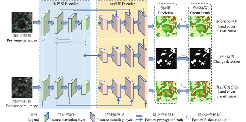
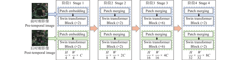
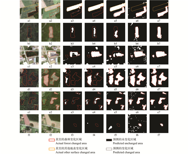
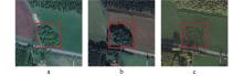
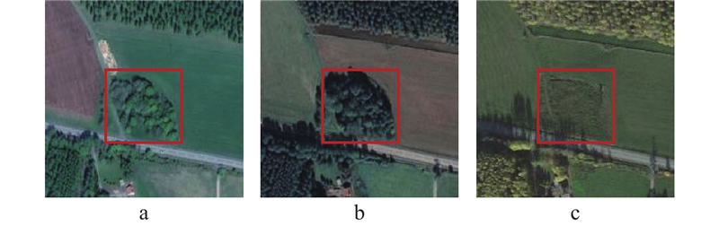
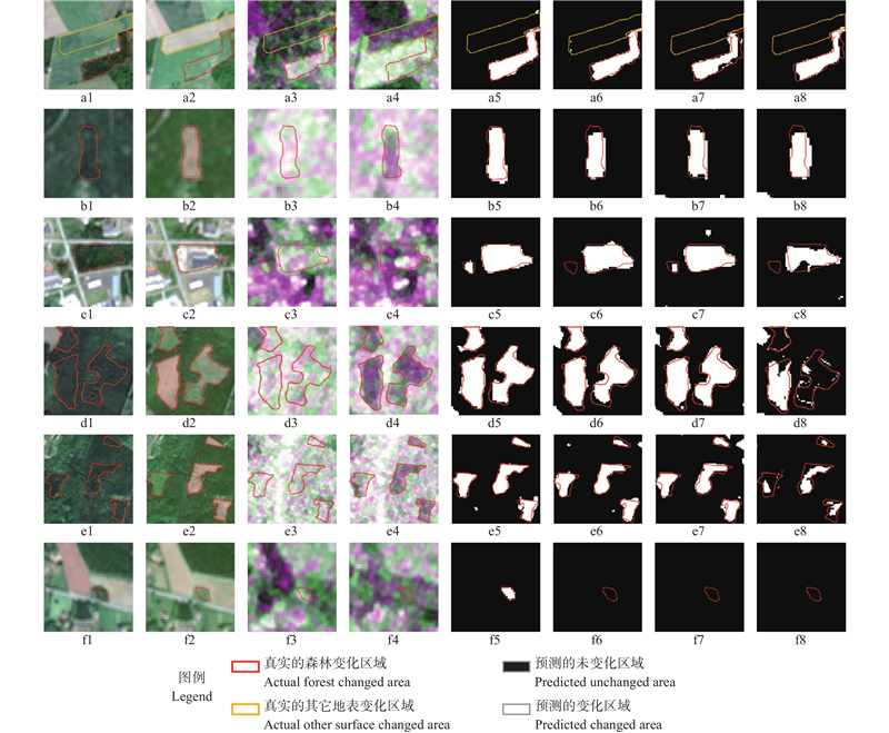
|
冯林艳, 谭炳香, 王晓慧, 等. 基于高分二号影像的森林变化快速检测方法研究. 林业科学研究, 2019, 32 (5): 142- 148.
|
|
Feng L Y, Tan B X, Wang X H, et al. Study on rapid forest change detection method based on GF-2 images. Forest Research, 2019, 32 (5): 142- 148.
|
|
李春干, 代华兵. 基于统计检验的面向对象高分辨率遥感图像森林变化检测. 林业科学, 2017, 53 (5): 74- 81.
|
|
Li C G, Dai H B. Statistical object-based method for forest change detection using high-resolution remote sensing images. Scientia Silvae Sinicae, 2017, 53 (5): 74- 81.
|
|
李德仁. 利用遥感影像进行变化检测. 武汉大学学报(信息科学版), 2003 (S1): 7- 12.
|
|
Li D R. Change detection from remote sensing images. Geomatics and Information Science of Wuhan University, 2003 (S1): 7- 12.
|
|
王崇阳, 田 昕. 基于GF-1 PMS数据的森林覆盖变化检测. 遥感技术与应用, 2021, 36 (1): 208- 216.
|
|
Wang C Y, Tian X. Forest cover change detection based on GF-1 PMS data. Remote Sensing Technology and Application, 2021, 36 (1): 208- 216.
|
|
王晓强. 基于高分辨率遥感影像的厦门市森林资源动态监测与管理方法研究. 测绘与空间地理信息, 2021, 44 (12): 94- 97.
|
|
Wang X Q. Research on dynamic monitoring and management methods of forest resources in Xiamen city based on high-resolution remote sensing images. Geomatics & Spatial Information Technology, 2021, 44 (12): 94- 97.
|
|
张良培, 武 辰. 多时相遥感影像变化检测的现状与展望. 测绘学报, 2017, 46 (10): 1447- 1459.
|
|
Zhang L P, Wu C. Advance and future development of change detection for multi-temporal remote sensing imagery. Acta Geodaetica et Cartographica Sinica, 2017, 46 (10): 1447- 1459.
|
|
Alshehri M, Ouadou A, Scott G J. Deep transformer-based network deforestation detection in the Brazilian Amazon using Sentinel-2 imagery. IEEE Geoscience and Remote Sensing Letters, 2024, 21, 1- 5.
doi: 10.1109/LGRS.2024.3355104
|
|
Bu L J, Zhang J Y, Zhang Z P, et al. Enhancing RABASAR for multi-temporal SAR image despeckling through directional filtering and wavelet transform. Sensors, 2023, 23 (21): 8916.
doi: 10.3390/s23218916
|
|
Chen H, Qi Z P, Shi Z W. Remote sensing image change detection with transformers. IEEE Transactions on Geoscience and Remote Sensing, 2022, 60, 1- 14.
|
|
Cheng J D, Zhang F, Xiang D L, et al. PolSAR image land cover classification based on hierarchical capsule network. Remote Sensing, 2021, 13 (16): 3132.
doi: 10.3390/rs13163132
|
|
Cheng K, Su Y J, Guan H C, et al. Mapping China's planted forests using high resolution imagery and massive amounts of crowdsourced samples. ISPRS Journal of Photogrammetry and Remote Sensing, 2023, 196, 356- 371.
doi: 10.1016/j.isprsjprs.2023.01.005
|
|
Choi H, Jeong J. Speckle noise reduction technique for SAR images using statistical characteristics of speckle noise and discrete wavelet transform. Remote Sensing, 2019, 11 (10): 1184.
doi: 10.3390/rs11101184
|
|
Curtis P G, Slay C M, Harris N L, et al. Classifying drivers of global forest loss. Science, 2018, 361 (6407): 1108- 1111.
doi: 10.1126/science.aau3445
|
|
Deng J S, Wang K, Deng Y H, et al. PCA-based land-use change detection and analysis using multitemporal and multisensor satellite data. International Journal of Remote Sensing, 2008, 29 (16): 4823- 4838.
doi: 10.1080/01431160801950162
|
|
Dosovitskiy A, Beyer L, Kolesnikov A, et al. 2021., An image is worth 16x16 words: transformers for image recognition at scale.. International Conference on Learning Representations, 611−631..
|
|
Hu J R, Zhang Y. Seasonal change of land-use/land-cover (LULC) detection using MODIS data in rapid urbanization regions: a case study of the pearl river delta region (China). IEEE Journal of Selected Topics in Applied Earth Observations and Remote Sensing, 2013, 6 (4): 1913- 1920.
doi: 10.1109/JSTARS.2012.2228469
|
|
Im J, Jensen J R. A change detection model based on neighborhood correlation image analysis and decision tree classification. Remote Sensing of Environment, 2005, 99 (3): 326- 340.
doi: 10.1016/j.rse.2005.09.008
|
|
Isaienkov K, Yushchuk M, Khramtsov V, et al. Deep learning for regular change detection in Ukrainian forest ecosystem with Sentinel-2. IEEE Journal of Selected Topics in Applied Earth Observations and Remote Sensing, 2021, 14, 364- 376.
doi: 10.1109/JSTARS.2020.3034186
|
|
John D, Zhang C. An attention-based U-Net for detecting deforestation within satellite sensor imagery. International Journal of Applied Earth Observation and Geoinformation, 2022, 107, 102685.
doi: 10.1016/j.jag.2022.102685
|
|
Latifi H, Heurich M. Multi-scale remote sensing-assisted forest inventory: a glimpse of the state-of-the-art and future prospects. Remote Sensing, 2019, 11 (11): 1260.
doi: 10.3390/rs11111260
|
|
Liu T, Yang L X, Lunga D. Change detection using deep learning approach with object-based image analysis. Remote Sensing of Environment, 2021a, 256, 112308.
doi: 10.1016/j.rse.2021.112308
|
|
Liu Z, Lin Y T, Cao Y, et al. 2021b. Swin Transformer: hierarchical vision transformer using shifted windows. 2021 IEEE/CVF International Conference on Computer Vision (ICCV), 9992−10002.
|
|
Martone M, Rizzoli P, Wecklich C, et al. The global forest/non-forest map from TanDEM-X interferometric SAR data. Remote Sensing of Environment, 2018, 205, 352- 373.
doi: 10.1016/j.rse.2017.12.002
|
|
Molini A B, Valsesia D, Fracastoro G, et al. Speckle2Void: deep self-supervised SAR despeckling with blind-spot convolutional neural networks. IEEE Transactions on Geoscience and Remote Sensing, 2022, 60, 1- 17.
doi: 10.1109/TGRS.2021.3065461
|
|
Nemmour H, Chibani Y. Multiple support vector machines for land cover change detection: an application for mapping urban extensions. ISPRS Journal of Photogrammetry and Remote Sensing, 2006, 61 (2): 125- 133.
doi: 10.1016/j.isprsjprs.2006.09.004
|
|
Nielsen A A. The regularized iteratively reweighted MAD method for change detection in multi- and hyperspectral data. IEEE Transactions on Image Processing, 2007, 16 (2): 463- 478.
doi: 10.1109/TIP.2006.888195
|
|
Sebastianelli A, Rosso M P D, Ullo S L, et al. A speckle filter for Sentinel-1 SAR ground range detected data based on residual convolutional neural networks. IEEE Journal of Selected Topics in Applied Earth Observations and Remote Sensing, 2022, 15, 5086- 5101.
doi: 10.1109/JSTARS.2022.3184355
|
|
Seidl R, Spies T A, Peterson D L, et al. Searching for resilience: addressing the impacts of changing disturbance regimes on forest ecosystem services. Journal of Applied Ecology, 2016, 53 (1): 120- 129.
doi: 10.1111/1365-2664.12511
|
|
Su H, Zhang X Z, Luo Y Q, et al. Nonlocal feature learning based on a variational graph auto-encoder network for small area change detection using SAR imagery. ISPRS Journal of Photogrammetry and Remote Sensing, 2022, 193, 137- 149.
doi: 10.1016/j.isprsjprs.2022.09.006
|
|
Wittstruck L, Jarmer T, Waske B. Multi-stage feature fusion of multispectral and SAR satellite images for seasonal crop-type mapping at regional scale using an adapted 3D U-Net model. Remote Sensing, 2024, 16 (17): 3115.
doi: 10.3390/rs16173115
|
|
Wessels K J, Van den Bergh F, Roy D P, et al. Rapid land cover map updates using change detection and robust random forest classifiers. Remote Sensing, 2016, 8 (11): 888.
doi: 10.3390/rs8110888
|
|
Xiao P F, Sheng G W, Zhang X L, et al. Direction-dominated change vector analysis for forest change detection. International Journal of Applied Earth Observation and Geoinformation, 2021, 103, 102492.
doi: 10.1016/j.jag.2021.102492
|
|
Zhang C X, Yue P, Tapete D, et al. A deeply supervised image fusion network for change detection in high resolution bi-temporal remote sensing images. ISPRS Journal of Photogrammetry and Remote Sensing, 2020, 166, 183- 200.
doi: 10.1016/j.isprsjprs.2020.06.003
|
|
Zhang C, Wang L J, Cheng S L, et al. SwinSUNet: pure transformer network for remote sensing image change detection. IEEE Transactions on Geoscience and Remote Sensing, 2022, 60, 1- 13.
doi: 10.1109/TGRS.2022.3160007
|
|
Zhang X, Zhao T T, Xu H, et al. GLC_FCS30D: the first global 30 m land-cover dynamics monitoring product with a fine classification system for the period from 1985 to 2022 generated using dense-time-series Landsat imagery and the continuous change-detection method. Earth System Science Data, 2024, 16 (3): 1353- 1381.
doi: 10.5194/essd-16-1353-2024
|
|
Zhao F, Sun R, Zhong L H, et al. Monthly mapping of forest harvesting using dense time series Sentinel-1 SAR imagery and deep learning. Remote Sensing of Environment, 2022, 269, 112822.
doi: 10.1016/j.rse.2021.112822
|

 )
)