
林业科学 ›› 2026, Vol. 62 ›› Issue (4): 68-80.doi: 10.11707/j.1001-7488.LYKX20250309
曾伟生1,*( ),温雪香1,付涵2,孙乡楠1,吕康梅3,刘樯漪1,王甜1
收稿日期:2025-05-14
出版日期:2026-04-15
发布日期:2026-04-11
通讯作者:
曾伟生
E-mail:zengweisheng0928@126.com
基金资助:
Weisheng Zeng1,*(),Xuexiang Wen1,Han Fu2,Xiangnan Sun1,Kangmei Lü3,Qiangyi Liu1,Tian Wang1
Received:2025-05-14
Online:2026-04-15
Published:2026-04-11
Contact:
Weisheng Zeng
E-mail:zengweisheng0928@126.com
摘要:
目的: 探索基于激光雷达数据构建主要林分因子模型估计乔木林小班因子的可行性,为推进激光雷达技术在全国林草综合监测中的应用提供示范。方法: 基于北京市1 966块乔木林样地激光雷达点云参数和地面实测数据,应用误差变量联立方程组方法,分13种森林类型构建林分平均胸径、平均高、优势高、每公顷株数、断面积、蓄积量、生物量和碳储量共8项林分因子预估模型;利用全市乔木林小班范围内按25 m×25 m网格单元提取的激光雷达点云参数,采用所建8项林分因子预估模型完成对所有乔木林小班因子的估计。结果: 1) 对估计主要林分因子贡献最大的激光雷达点云参数为累计高度80%分位数和点云高度中位数,其次为叶面积指数;2) 所建13种森林类型的8项林分因子预估模型,自检和交叉检验的平均预估误差(MPE)均在15%以内;3) 以森林为总体进行评价,8项林分因子预估模型的确定系数(R2)均达0.7以上(每公顷株数除外),MPE均在3%以内,平均百分标准误差(MPSE)均在40%以内,其中平均胸径、平均高和优势高模型的MPSE达15%左右;4) 根据模型反演得出的乔木林小班蓄积量累计值与全市综合监测得到的森林蓄积量相比仅差?1.79%,3个副总体范围内的乔木林小班蓄积量与综合监测结果相比也仅分别相差1.04%、?3.91%和?5.44%,均在抽样调查允许误差范围内。结论: 1) 对估计主要林分因子贡献最大的激光雷达点云参数为累计高度80%分位数和点云高度中位数,其次为叶面积指数,点云强度和密度参数的作用不显著;2) 应用误差变量联立方程组方法构建主要林分因子联立模型,可同时解决不同模型参数的相容性和不同林分因子估计的误差传递问题;3) 所建13种森林类型的8项林分因子预估模型,可用于对全市乔木林小班主要林分因子的估计;4) 基于激光雷达点云参数构建主要林分因子模型,其预估精度能够满足森林资源调查监测技术要求,可在生产实践中推广应用。
中图分类号:
曾伟生,温雪香,付涵,孙乡楠,吕康梅,刘樯漪,王甜. 基于激光雷达的北京市主要林分因子联立模型构建与应用[J]. 林业科学, 2026, 62(4): 68-80.
Weisheng Zeng,Xuexiang Wen,Han Fu,Xiangnan Sun,Kangmei Lü,Qiangyi Liu,Tian Wang. Establishment and Application of Simultaneous Models for Estimating Major Stand Characteristics in Beijing Based on LiDAR Data[J]. Scientia Silvae Sinicae, 2026, 62(4): 68-80.
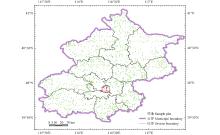
图1
研究区范围及样地分布"
表1
建模样地8项主要林分因子的统计特征数"
| 特征数 Statistics | 平均胸径 Mean diameter at breast height (D)/cm | 平均高 Mean height (H)/m | 优势高 Dominant height (Hd)/m | 株数 Stem number (N)/ (tree·hm?2) | 断面积 Basal area (G)/(m2·hm?2) | 蓄积量 Stock volume (V)/(m3·hm?2) | 生物量 Biomass (B)/(t·hm?2) | 碳储量 Carbon storage (C)/ (t·hm?2) |
| 平均数Mean | 14.0 | 8.8 | 10.3 | 771 | 10.8 | 59.0 | 68.8 | 33.2 |
| 最小值Min. | 5.0 | 1.9 | 2.0 | 15 | 0.1 | 0.1 | 0.1 | 0.1 |
| 最大值Max. | 44.8 | 27.4 | 28.1 | 43.9 | 435.4 | 338.6 | 163.7 | |
| 标准差Standard deviation (SD) | 6.1 | 3.9 | 4.4 | 598 | 7.8 | 57.5 | 54.9 | 26.5 |
| 变动系数Coefficient of variation (CV)(%) | 43.6 | 44.2 | 42.4 | 77.6 | 72.8 | 97.4 | 79.7 | 79.7 |
表2
13种森林类型的联立模型参数估计值①"
| 森林类型 Forest type | 林分因子 Stand factor | 解释变量 Explanatory variable | 参数估计值Parameter estimates | ||||
| a0~g0 | a1~f1 | a2~c2 | a3~c3 | a4~c4 | |||
| 油松林 Pinus tabuliformis forest (n=200) | D | X1、X3、X5 | 10.213 0 | 0.202 2 | 0.187 6 | 0.037 8 | |
| Hd | X1、X3 | 2.238 1 | ?0.099 2 | 0.795 9 | |||
| G | X4、X5 | 2.433 3 | 0.586 0 | 0.663 5 | |||
| V | X1、X3、X5 | 11.427 0 | 0.690 2 | 0.364 9 | 0.682 1 | ||
| H | 0.031 7 | 0.836 1 | |||||
| B | 0.474 7 | 0.988 2 | |||||
| C | 0.509 3 | ||||||
| 侧柏林 Platycladus orientalis forest (n=100) | D | X1、X3、X5 | 4.912 8 | 0.679 5 | 0.271 0 | ?0.097 9 | |
| Hd | X1、X3 | 4.914 1 | 0.441 9 | 0.230 5 | |||
| G | X4、X5 | 0.684 0 | 1.470 0 | 0.473 1 | |||
| V | X4、X5 | 1.612 7 | 1.864 2 | 0.438 7 | |||
| H | ?0.149 7 | 0.861 4 | |||||
| B | 0.981 3 | 1.329 7 | |||||
| C | 0.484 3 | ||||||
| 针叶混交林 Coniferous mixed forest (n=100) | D | X1、X2、X5 | 4.100 4 | 0.396 0 | 0.313 4 | ?0.104 4 | |
| H | X2、X4 | 2.874 4 | 0.111 6 | 0.444 2 | |||
| G | X1、X5 | 2.128 2 | 1.039 6 | 0.472 6 | |||
| V | X1、X5 | 5.514 7 | 1.444 9 | 0.507 1 | |||
| Hd | 0.290 5 | 1.244 1 | |||||
| B | 2.441 4 | 1.180 1 | |||||
| C | 0.489 9 | ||||||
| 栎树林 Quercus spp. forest (n=200) | D | X2、X5 | 4.273 6 | 0.561 0 | ?0.124 6 | ||
| Hd | X2、X4 | 2.878 6 | 0.895 1 | ?0.346 7 | |||
| G | X3、X5 | 8.005 4 | 1.120 4 | 0.081 3 | |||
| V | X3、X4 | 22.55 7 | 1.185 6 | 0.305 7 | |||
| H | 0.345 2 | 0.767 9 | |||||
| B | 3.072 4 | 1.350 2 | |||||
| C | 0.480 3 | ||||||
| 桦木林 Betula spp. forest (n=88) | D | X1、X2 | 1.307 4 | ?0.229 7 | 1.121 6 | ||
| Hd | X2 | 2.197 8 | 0.707 4 | ||||
| G | X3、X4 | 1.013 2 | 0.121 3 | 1.253 8 | |||
| V | X3、X4 | 3.389 6 | 0.380 7 | 1.376 5 | |||
| H | 0.058 6 | 0.817 9 | |||||
| B | 3.776 8 | 1.098 0 | |||||
| C | 0.484 1 | ||||||
| 杨树林 Populus spp. forest (n=200) | D | X1、X2 | 3.925 5 | 0.110 7 | 0.572 5 | ||
| Hd | X2 | 5.228 9 | 0.446 9 | ||||
| G | X2 | 0.558 3 | 1.198 6 | ||||
| V | X2 | 2.066 6 | 1.495 0 | ||||
| H | ?0.582 8 | 0.926 8 | |||||
| B | 1.304 9 | 0.802 5 | |||||
| C | 0.472 5 | ||||||
| 榆树林 Ulmus spp. forest (n=100) | D | X2、X5 | 2.488 9 | 0.806 9 | ?0.031 4 | ||
| Hd | X2 | 2.129 4 | 0.744 5 | ||||
| G | X4、X5 | 0.446 3 | 1.428 0 | 0.161 8 | |||
| V | X4、X5 | 1.055 4 | 1.778 8 | 0.153 7 | |||
| H | ?0.133 1 | 0.871 9 | |||||
| B | 0.895 1 | 1.100 1 | |||||
| C | 0.449 4 | ||||||
| 刺槐林 Robinia pseudoacacia forest (n=100) | D | X2、X5 | 2.774 1 | 0.762 0 | ?0.033 7 | ||
| H | X2 | 2.952 8 | 0.566 8 | ||||
| G | X2 | 0.222 2 | 1.625 1 | ||||
| V | X2 | 0.772 8 | 1.838 0 | ||||
| Hd | 0.125 2 | 1.144 2 | |||||
| B | 1.434 7 | 1.341 0 | |||||
| C | 0.482 9 | ||||||
| 柳树林 Salix spp. forest (n=88) | D | X1、X2 | 1.296 6 | ?0.198 0 | 1.103 0 | ||
| H | X2 | 1.775 8 | 0.713 7 | ||||
| G | X3、X4 | 1.159 0 | 0.262 9 | 1.144 8 | |||
| V | X3、X4 | 4.007 4 | 0.501 8 | 1.259 7 | |||
| Hd | 0.027 6 | 1.216 7 | |||||
| B | 2.998 3 | 1.107 9 | |||||
| C | 0.484 2 | ||||||
| 乔木经济林 Economic forest of trees (n=90) | D | X3、X5 | 13.525 0 | 0.561 5 | ?0.105 3 | ||
| Hd | X3 | 8.457 3 | 0.369 2 | ||||
| G | X3 | 6.283 6 | 1.003 0 | ||||
| V | X3 | 24.672 0 | 1.225 4 | ||||
| H | 0.941 4 | 0.739 9 | |||||
| B | 2.849 4 | 1.782 5 | |||||
| C | 0.483 7 | ||||||
| 其他硬阔林 Other hard broad-leaved forest (n=300) | D | X2、X5 | 3.595 5 | 0.695 9 | ?0.010 3 | ||
| Hd | X2 | 2.870 8 | 0.594 4 | ||||
| G | X2、X4 | 0.389 2 | 0.323 5 | 1.297 2 | |||
| V | X2、X4 | 0.857 8 | 0.542 9 | 1.434 9 | |||
| H | 0.116 4 | 0.878 1 | |||||
| B | 2.198 5 | 1.512 5 | |||||
| C | 0.483 5 | ||||||
| 其他软阔林 Other soft broad-leaved forest (n=100) | D | X1、X2、X4、X5 | 2.268 1 | 0.644 6 | 1.380 1 | ?1.149 3 | ?0.106 3 |
| Hd | X2、X5 | 1.885 4 | 0.774 4 | ?0.071 5 | |||
| G | X2 | 0.102 6 | 2.060 6 | ||||
| V | X2 | 0.202 3 | 2.436 3 | ||||
| H | 0.460 6 | 0.796 8 | |||||
| B | 1.944 9 | 1.259 6 | |||||
| C | 0.480 8 | ||||||
| 阔叶混交林 Broad-leaved mixed forest (n=300) | D | X1、X2、X4、X5 | 2.860 9 | 0.242 6 | 1.044 8 | ?0.583 1 | ?0.131 5 |
| H | X2、X5 | 2.487 6 | 0.593 4 | ?0.037 7 | |||
| G | X1、X3、X5 | 2.400 7 | 0.722 5 | 0.676 3 | 0.225 8 | ||
| V | X1、X3、X5 | 7.772 3 | 0.923 4 | 0.899 9 | 0.206 3 | ||
| Hd | ?0.520 6 | 1.286 7 | |||||
| B | 4.350 3 | 1.181 6 | |||||
| C | 0.478 8 | ||||||
表3
森林、针叶林和阔叶林模型的评价指标①"
| 森林类型 Forest type | 林分因子 Stand factor | 自检结果Self-validation results | 交叉检验结果Cross-validation results | |||||||||||
| R2 | SEE | TRE | ASE | MPE | MPSE | R2 | SEE | TRE | ASE | MPE | MPSE | |||
| 森林 Forest | D | 0.731 | 3.20 | 1.97 | 1.75 | 1.01 | 15.52 | 0.715 | 3.27 | 2.05 | 2.05 | 1.03 | 15.88 | |
| H | 0.773 | 1.87 | 0.13 | ?0.71 | 0.94 | 15.27 | 0.760 | 1.91 | 0.13 | ?0.52 | 0.96 | 15.58 | ||
| Hd | 0.766 | 2.14 | 0.08 | ?0.88 | 0.92 | 15.79 | 0.755 | 2.18 | 0.18 | ?0.60 | 0.93 | 15.94 | ||
| G | 0.726 | 4.14 | 0.40 | 0.47 | 1.70 | 31.50 | 0.708 | 4.30 | 1.10 | 1.94 | 1.73 | 31.64 | ||
| N | 0.536 | 416 | 3.55 | 3.70 | 2.39 | 38.73 | 0.517 | 430 | 4.48 | 5.11 | 2.42 | 39.38 | ||
| V | 0.767 | 28.0 | 1.22 | ?2.43 | 2.10 | 34.28 | 0.752 | 28.9 | 1.61 | ?0.93 | 2.12 | 34.29 | ||
| B | 0.703 | 30.4 | ?0.30 | 0.90 | 1.95 | 34.38 | 0.684 | 31.7 | 0.28 | 2.38 | 1.99 | 34.49 | ||
| C | 0.701 | 14.7 | ?0.35 | 0.98 | 1.96 | 34.42 | 0.682 | 15.4 | 0.23 | 2.46 | 2.00 | 34.53 | ||
| 针叶林 Coniferous forest | D | 0.683 | 2.15 | 1.06 | 1.33 | 1.74 | 13.35 | 0.662 | 2.22 | 1.00 | 1.35 | 1.80 | 13.81 | |
| H | 0.752 | 1.44 | ?0.31 | ?1.55 | 2.01 | 14.19 | 0.733 | 1.49 | ?0.16 | ?1.32 | 2.08 | 14.55 | ||
| Hd | 0.723 | 1.84 | ?0.37 | ?1.81 | 2.12 | 15.80 | 0.705 | 1.89 | ?0.23 | ?1.58 | 2.18 | 16.10 | ||
| G | 0.839 | 3.22 | ?0.98 | 1.05 | 2.79 | 21.42 | 0.832 | 3.29 | ?1.13 | 0.99 | 2.84 | 21.58 | ||
| N | 0.538 | 368 | 2.85 | 4.45 | 3.83 | 31.05 | 0.511 | 379 | 2.83 | 4.81 | 3.95 | 31.83 | ||
| V | 0.837 | 23.6 | 1.49 | ?1.43 | 4.06 | 23.59 | 0.829 | 24.1 | 1.32 | ?1.36 | 4.16 | 23.88 | ||
| B | 0.806 | 22.4 | ?2.77 | 1.23 | 3.61 | 24.62 | 0.792 | 23.2 | ?3.01 | 1.25 | 3.73 | 25.05 | ||
| C | 0.808 | 11.2 | ?2.81 | 1.20 | 3.61 | 24.40 | 0.794 | 11.6 | ?3.05 | 1.22 | 3.74 | 24.82 | ||
| 阔叶林 Broadleaved forest | D | 0.727 | 3.41 | 2.17 | 1.85 | 1.17 | 16.07 | 0.712 | 3.49 | 2.28 | 2.23 | 1.19 | 16.41 | |
| H | 0.762 | 1.96 | 0.21 | ?0.50 | 1.06 | 15.55 | 0.748 | 2.01 | 0.18 | ?0.32 | 1.07 | 15.84 | ||
| Hd | 0.761 | 2.21 | 0.17 | ?0.64 | 1.01 | 15.79 | 0.749 | 2.24 | 0.26 | ?0.35 | 1.02 | 15.90 | ||
| G | 0.696 | 4.34 | 0.78 | 0.33 | 2.03 | 34.07 | 0.676 | 4.52 | 1.71 | 2.18 | 2.05 | 34.21 | ||
| N | 0.524 | 427 | 3.79 | 3.50 | 2.92 | 40.69 | 0.508 | 442 | 5.02 | 5.18 | 2.94 | 41.31 | ||
| V | 0.749 | 29.0 | 1.16 | ?2.68 | 2.42 | 37.01 | 0.732 | 30.0 | 1.68 | ?0.82 | 2.44 | 36.95 | ||
| B | 0.680 | 32.1 | 0.26 | 0.82 | 2.25 | 36.87 | 0.659 | 33.5 | 1.01 | 2.67 | 2.27 | 36.91 | ||
| C | 0.677 | 15.5 | 0.24 | 0.92 | 2.27 | 36.98 | 0.656 | 16.2 | 0.99 | 2.78 | 2.29 | 37.02 | ||
图2
森林蓄积量、生物量和碳储量模型的拟合效果"
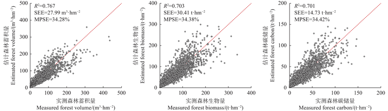
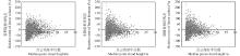
图3
森林三储量模型的相差残差分布"
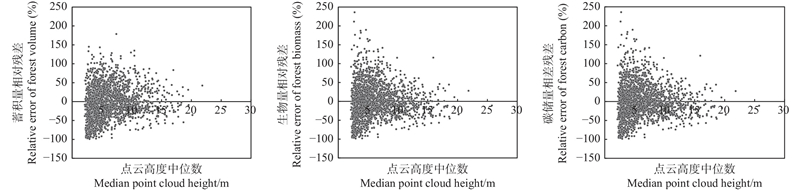

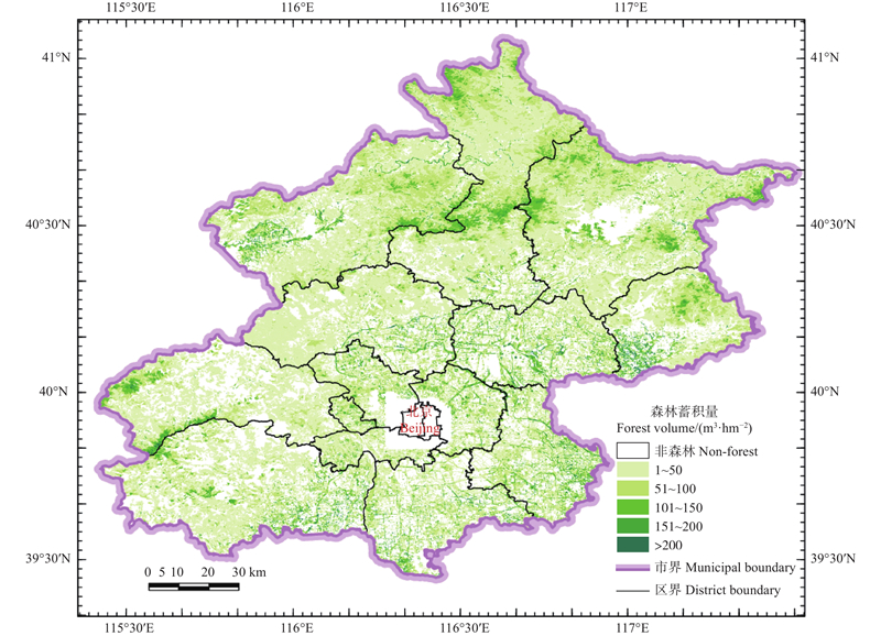
图4
森林蓄积量分布"
| 曹 林, 代劲松, 徐建新, 等. 基于机载小光斑LiDAR技术的亚热带森林参数信息优化提取. 北京林业大学学报, 2014, 36 (5): 13- 21. | |
| Cao L, Dai J S, Xu J X, et al. Optimized extraction of forest parameters in subtropical forests based on airborne small footprint LiDAR technology. Journal of Beijing Forestry University, 2014, 36 (5): 13- 21. | |
|
代华兵, 李春干, 庞 勇, 等. 基于天空地一体化森林资源调查的小班因子设置与信息获取方法. 林业资源管理, 2021, (1): 180- 188.
doi: 10.13466/j.cnki.lyzygl.2021.01.023 |
|
|
Dai H B, Li C G, Pang Y, et al. Method for sub-compartment investigation factors setting and information acquisition based on integrated aerial-space-ground forest inventory system. Forest Resources Management, 2021, (1): 180- 188.
doi: 10.13466/j.cnki.lyzygl.2021.01.023 |
|
|
丁志文, 邢艳秋, 尹伯卿, 等. 融合无人机和地基激光雷达点云数据估测单木结构参数. 森林工程, 2024, 40 (1): 142- 151.
doi: 10.3969/j.issn.1006-8023.2024.01.017 |
|
|
Ding Z W, Xing Y Q, Yin B Q, et al. Fusion of UAV and TLS LiDAR point cloud data for estimating individual tree structure parameters. Forest Engineering, 2024, 40 (1): 142- 151.
doi: 10.3969/j.issn.1006-8023.2024.01.017 |
|
| 范凤云. 2010,. 基于机载LiDAR和极化SAR数据的山区森林蓄积量估测方法研究. 北京: 中国林业科学研究院. | |
| Fan F Y. 2010,. Study on the estimation method of forest volume using airbrone LiDAR and polarimetric SAR over hilly region. Beijing: Chinese Academy of Forestry. [in Chinese] | |
| 付 甜. 2010,. 基于机载激光雷达的亚热带森林参数估测. 合肥: 安徽农业大学. | |
| Fu T. 2010,. Estimation of forest parameters based on airborne laser scanning in subtropical zone. Hefei: Anhui Agricultural University. [in Chinese] | |
|
雷宇宙, 毛学刚. 结合UAV-LiDAR和Sentinel-2的森林蓄积量估测. 森林工程, 2023, 39 (6): 46- 54.
doi: 10.3969/j.issn.1006-8023.2023.06.001 |
|
|
Lei Y Z, Mao X G. Integrating UAV-LiDAR and Sentinel-2 for growing stock volume estimation. Forest Engineering, 2023, 39 (6): 46- 54.
doi: 10.3969/j.issn.1006-8023.2023.06.001 |
|
| 李春干, 李 振. 机载激光雷达大区域亚热带森林参数估测的普适性模型式. 林业科学, 2021, 57 (10): 23- 35. | |
| Li C G, Li Z. Generalizing predictive models of sub-tropical forest inventory attributes using an area-based approach with airborne LiDAR data. Scientia Silvae Sinicae, 2021, 57 (10): 23- 35. | |
| 李苑鑫, 吴楚航, 邢艳秋. 基于地基激光雷达人工蒙古栎削度−二元材积方程的构建. 森林工程, 2025, 41 (1): 162- 173. | |
| Li Y X, Wu C H, Xing Y Q. Construction of a taper-binary volume equation for plantation Mongolian oak based on TLS data. Forest Engineering, 2025, 41 (1): 162- 173. | |
|
李增元, 刘清旺, 庞 勇. 激光雷达森林参数反演研究进展. 遥感学报, 2016, 20 (5): 1138- 1150.
doi: 10.13198/j.issn.1001-6929.2024.11.07 |
|
|
Li Z Y, Liu Q W, Pang Y. Review on forest parameters inversion using LiDAR. Journal of Remote Sensing, 2016, 20 (5): 1138- 1150.
doi: 10.13198/j.issn.1001-6929.2024.11.07 |
|
|
刘鲁霞, 庞 勇. 机载激光雷达和地基激光雷达林业应用现状. 世界林业研究, 2014, 27 (1): 49- 56.
doi: 10.13348/j.cnki.sjlyyj.2014.01.009 |
|
|
Liu L X, Pang Y. Applications of airborne laser scanning and terrestrial laser scanning to forestry. World Forestry Research, 2014, 27 (1): 49- 56.
doi: 10.13348/j.cnki.sjlyyj.2014.01.009 |
|
| 刘清旺, 谭炳香, 胡凯龙, 等. 机载激光雷达和高光谱组合系统的亚热带森林估测遥感试验. 高技术通讯, 2016, 26 (3): 264- 274. | |
| Liu Q W, Tan B X, Hu K L, et al. The remote sensing experiment on airborne LiDAR and hyperspectral integrated system for subtropical forest estimation. Chinese High Technology Letters, 2016, 26 (3): 264- 274. | |
| 庞 勇, 李增元. 基于机载激光雷达的小兴安岭温带森林组分生物量反演. 植物生态学报, 2012, 36 (10): 1095- 1105. | |
| Pang Y, Li Z Y. Inversion of biomass components of the temperate forest using airborne LiDAR technology in Xiaoxing’an Mountains, northeastern of China. Chinese Journal of Plant Ecology, 2012, 36 (10): 1095- 1105. | |
|
庞 勇, 李增元, 陈博伟, 等. 星载激光雷达森林探测进展及趋势. 上海航天, 2019, 36 (3): 20- 28.
doi: 10.19328/j.cnki.1006-1630.2019.03.003 |
|
|
Pang Y, Li Z Y, Chen B W, et al. Status and development of spaceborne LiDAR applications in forestry. Aerospace Shanghai, 2019, 36 (3): 20- 28.
doi: 10.19328/j.cnki.1006-1630.2019.03.003 |
|
| 薛春泉, 陈振雄, 杨加志, 等. 省市县一体化森林碳储量估测技术体系: 以广东省为例. 林业资源管理, 2022, (4): 157- 163. | |
| Xue C Q, Chen Z X, Yang J Z, et al. A provincial-municipal-county integrated forest carbon storage estimating technology system: take Guangdong Province as an example. Forest Resources Management, 2022, (4): 157- 163. | |
| 杨明星, 徐天蜀, 牛晓花, 等. 基于Sentinel-1A雷达影像的思茅松林蓄积量估测. 西部林业科学, 2019, 48 (2): 52- 58. | |
| Yang M X, Xu T S, Niu X H, et al. Estimation of Pinus kesiya var. langbianensis forest stock volume based on Sentinel-1A SAR image. Journal of West China Forestry Science, 2019, 48 (2): 52- 58. | |
|
袁钰娜, 彭道黎, 王 威, 等. 利用机载激光雷达技术估测东北林区典型针叶林的蓄积量. 应用生态学报, 2021, 32 (3): 836- 844.
doi: 10.13287/j.1001-9332.202103.001 |
|
|
Yuan Y N, Peng D L, Wang W, et al. Estimating standing stocks of the typical conifer stands in northeast China based on airborne LiDAR data. Chinese Journal of Applied Ecology, 2021, 32 (3): 836- 844.
doi: 10.13287/j.1001-9332.202103.001 |
|
|
曾伟生, 孙乡楠, 王六如, 等. 基于机载激光雷达数据估计林分蓄积量及平均高和断面积. 林业资源管理, 2020, (2): 79- 86.
doi: 10.13466/j.cnki.lyzygl.2020.02.013 |
|
|
Zeng W S, Sun X N, Wang L R, et al. Estimating forest volume, mean height and basal area based on airborne laser scanning data. Forest Resources Management, 2020, (2): 79- 86.
doi: 10.13466/j.cnki.lyzygl.2020.02.013 |
|
|
曾伟生, 孙乡楠, 王六如, 等. 基于激光雷达数据的东北林区航空林分材积表编制. 林业资源管理, 2021a, (1): 147- 155.
doi: 10.13466/j.cnki.lyzygl.2021.01.019 |
|
|
Zeng W S, Sun X N, Wang L R, et al. Developing aerial stand volume tables based on laser scanning data for forest region of northeast China. Forest Resources Management, 2021a, (1): 147- 155.
doi: 10.13466/j.cnki.lyzygl.2021.01.019 |
|
| 曾伟生, 孙乡楠, 王六如, 等. 基于机载激光雷达数据的森林蓄积量模型研建. 林业科学, 2021b, 57 (2): 31- 38. | |
| Zeng W S, Sun X N, Wang L R, et al. Development of forest stand volume models based on airborne laser scanning data. Scientia Silvae Sinicae, 2021b, 57 (2): 31- 38. | |
|
曾伟生, 孙乡楠, 王六如, 等. 东北林区10种主要森林类型的蓄积量、生物量和碳储量模型研建. 北京林业大学学报, 2021c, 43 (3): 1- 8.
doi: 10.12171/j.1000-1522.20200058 |
|
|
Zeng W S, Sun X N, Wang L R, et al. Developing stand volume, biomass and carbon stock models for ten major forest types in forest region of northeastern China. Journal of Beijing Forestry University, 2021c, 43 (3): 1- 8.
doi: 10.12171/j.1000-1522.20200058 |
|
| 曾伟生, 唐守正. 立木生物量方程的优度评价和精度分析. 林业科学, 2011a, 47 (11): 106- 113. | |
| Zeng W S, Tang S Z. Goodness evaluation and precision analysis of tree biomass equations. Scientia Silvae Sinicae, 2011a, 47 (11): 106- 113. | |
| 曾伟生, 唐守正. 2011b. 非线性模型对数回归的偏差校正及与加权回归的对比分析. 林业科学研究, 24(2): 137-143. | |
| Zeng W S, Tang S Z. 2011b. Bias correction in logarithmic regression and comparison with weighted regression for non-linear models. Forest Research, 24(2): 137-143. [in Chinese] | |
| 曾伟生, 杨学云, 孙乡楠, 等. 森林资源调查监测中各级储量数据的一体化方法研究. 林业资源管理, 2022, (4): 13- 19. | |
| Zeng W S, Yang X Y, Sun X N, et al. A study on integration of forest stock data at different levels in forest inventory and monitoring. Forest Resources Management, 2022, (4): 13- 19. | |
| 周相贝, 李春干, 代华兵, 等. 点云密度对机载激光雷达大区域亚热带森林参数估测精度的影响. 林业科学, 2023, 59 (9): 23- 33. | |
| Zhou X B, Li C G, Dai H B, et al. Effects of point cloud density on the estimation accuracy of large-area subtropical forest inventory attributes using airborne LiDAR data. Scientia Silvae Sinicae, 2023, 59 (9): 23- 33. | |
| 赵 峰, 李增元, 王韵晟, 等. 机载激光雷达(LiDAR)数据在森林资源调查中的应用综述. 遥感信息, 2008, 23 (1): 106- 110, 53. | |
| Zhao F, Li Z Y, Wang Y S, et al. The application of LiDAR data in forest. Remote Sensing Information, 2008, 23 (1): 106- 110, 53. | |
|
邹文涛, 曾伟生, 孙乡楠. 基于机载激光雷达数据估计主要森林参数联立模型. 中南林业调查规划, 2024, 43 (4): 32- 38.
doi: 10.16166/j.cnki.cn43-1095.2024.04.007 |
|
|
Zou W T, Zeng W S, Sun X N. Joint modeling for estimating major forest parameters based on airborne laser scanning data. Central South Forest Inventory and Planning, 2024, 43 (4): 32- 38.
doi: 10.16166/j.cnki.cn43-1095.2024.04.007 |
|
|
Bottalico F, Chirici G, Giannini R, et al. Modeling Mediterranean forest structure using airborne laser scanning data. International Journal of Applied Earth Observation and Geoinformation, 2017, 57, 145- 153.
doi: 10.1016/j.jag.2016.12.013 |
|
| Bouvier M, Durrieu S, Fournier R A, et al. Generalizing predictive models of forest inventory attributes using an area-based approach with airborne LiDAR data. Remote Sensing of Environment, 2015, 156 (1): 322- 334. | |
|
González-Ferreiro E, Diéguez-Aranda U, Miranda D. Estimation of stand variables in Pinus radiata D. Don plantations using different LiDAR pulse densities. Forestry, 2012, 85 (2): 281- 292.
doi: 10.1093/forestry/cps002 |
|
|
Hollaus M, Dorigo W, Wagner W, et al. Operational wide-area stem volume estimation based on airborne laser scanning and national forest inventory data. International Journal of Remote Sensing, 2009, 30 (19): 5159- 5175.
doi: 10.1080/01431160903022894 |
|
|
Holmgren J. Prediction of tree height, basal area and stem volume in forest stands using airborne laser scanning. Scandinavian Journal of Forest Research, 2004, 19 (6): 543- 553.
doi: 10.1080/02827580410019472 |
|
|
Holmgren J, Nilsson M, Olsson H. Estimation of tree height and stem volume on plots using airborne laser scanning. Forest Science, 2003, 49 (3): 419- 428.
doi: 10.1093/forestscience/49.3.419 |
|
|
Hyyppä J, Yu X W, Hyyppä H, et al. Advances in forest inventory using airborne laser scanning. Remote Sensing, 2012, 4 (5): 1190- 1207.
doi: 10.3390/rs4051190 |
|
|
MacLean G A, Krabill W B. Gross-merchantable timber volume estimation using an airborne LiDAR system. Canadian Journal of Remote Sensing, 1986, 12 (1): 7- 18.
doi: 10.1080/07038992.1986.10855092 |
|
|
Næsset E. Estimating timber volume of forest stands using airborne laser scanner data. Remote Sensing of Environment, 1997, 61 (2): 246- 253.
doi: 10.1016/S0034-4257(97)00041-2 |
|
| Penner M, Pitt D, Woods M. Parametric vs. nonparametric LiDAR models for operational forest inventory in boreal Ontario. Canadian Journal of Remote Sensing, 2013, 39 (5): 426- 443. | |
|
White J C, Coops N C, Wulder M A, et al. Remote sensing technologies for enhancing forest inventories: a review. Canadian Journal of Remote Sensing, 2016, 42 (5): 619- 641.
doi: 10.1080/07038992.2016.1207484 |
|
| Zhang Z N, Wang T J, Skidmore A K, et al. An improved area-based approach for estimating plot-level tree DBH from airborne LiDAR data. Forest Ecosystems, 2023, 10 (1): 100089. | |
|
Zörner J, Dymond J R, Shepherd J D, et al. LiDAR-based regional inventory of tall trees: Wellington, New Zealand. Forests, 2018, 9 (11): 702.
doi: 10.3390/f9110702 |
|
|
Zou W T, Zeng W S, Sun X N. Simultaneous models for the estimation of main forest parameters based on airborne LiDAR data. Forests, 2024, 15 (5): 775.
doi: 10.3390/f15050775 |
| [1] | 吴家敏,王亚欣,孙斌,马志杰,孙维娜,洪亮. 基于无人机的柠条锦鸡儿生物量遥感估测[J]. 林业科学, 2025, 61(6): 13-24. |
| [2] | 符庆成,邱尔发,张媛,王慧超,黄岚虹. 北京市银杏古树心腐特征及其影响因素[J]. 林业科学, 2023, 59(6): 130-140. |
| [3] | 仇宽彪,李晓婷,成军锋,贾宝全. 基于形态学空间格局方法的北京市六环内城市林木树冠覆盖斑块动态特征[J]. 林业科学, 2023, 59(5): 11-20. |
| [4] | 郭泽鑫,胡中岳,曹聪,刘萍. 广东主要森林类型林分生物量和碳储量模型研建[J]. 林业科学, 2023, 59(12): 37-50. |
| [5] | 曾赞青,宋涵晴,高俊宏,王淼淼,武耀星,漆良华. 北京市森林植被固碳与能源碳排放时空变化及潜力预测[J]. 林业科学, 2023, 59(12): 51-60. |
| [6] | 刘子赫,贾国栋,刘自强,邓文平. 北京山区侧柏用水来源随水分条件变化的多时间尺度[J]. 林业科学, 2022, 58(3): 40-47. |
| [7] | 李晓婷,李彤,仇宽彪,姜莎莎,贾宝全. 城市森林林木斑块特征与降温效应的关系——以北京市城区为例[J]. 林业科学, 2021, 57(4): 32-42. |
| [8] | 张致义,辛琳,邱尔发,谢晓阳,王新宇,孙振凯,姜莎莎,赵娇. 冬奥快速通道林带四季美景度评价[J]. 林业科学, 2021, 57(12): 43-56. |
| [9] | 牛少锋,邱尔发,张致义,奚露. 北京城市河岸林木本植物种群多样性梯度变化[J]. 林业科学, 2020, 56(11): 198-206. |
| [10] | 马杰, 贾宝全. 北京市六环内城市道路附属绿地木本植物多样性及结构特征[J]. 林业科学, 2019, 55(4): 13-21. |
| [11] | 贾宝全, 仇宽彪. 北京市第二道绿化隔离区林木树冠覆盖特征与景观格局变化[J]. 林业科学, 2019, 55(2): 13-21. |
| [12] | 曾伟生, 贺东北, 蒲莹, 肖前辉. 含地域和起源因子的马尾松立木生物量与材积方程系统[J]. 林业科学, 2019, 55(2): 75-86. |
| [13] | 刘秀萍,贾宝全. 北京城区居住区树冠覆盖变化特征[J]. 林业科学, 2019, 55(12): 12-20. |
| [14] | 曾伟生,陈新云,杨学云. 我国人工杨树生物量建模和生产力分析[J]. 林业科学, 2019, 55(11): 1-8. |
| [15] | 刘自强, 余新晓, 贾国栋, 李瀚之, 路伟伟, 侯贵荣. 北京山区侧柏利用水分来源对降水的响应[J]. 林业科学, 2018, 54(7): 16-23. |
| 阅读次数 | ||||||
|
全文 |
|
|||||
|
摘要 |
|
|||||