|
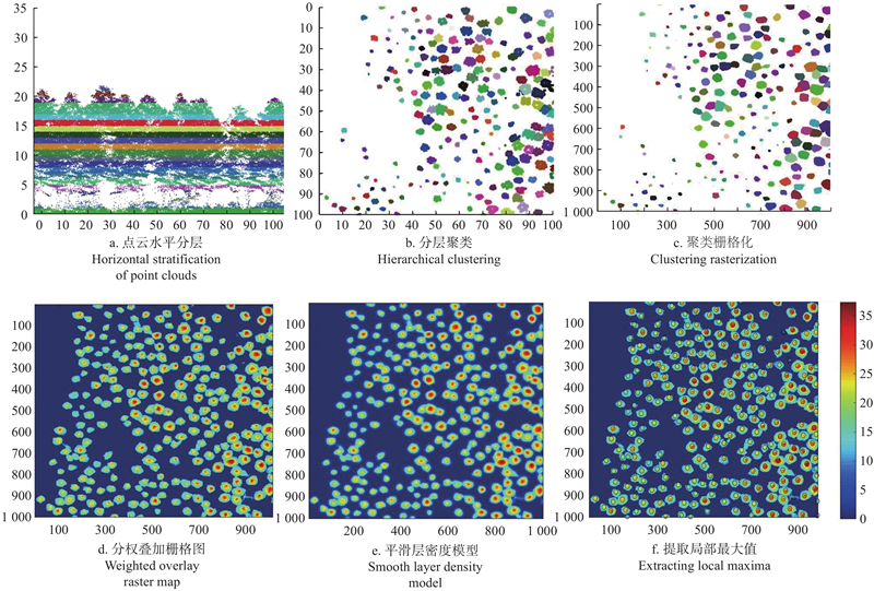
霍朗宁, 张晓丽. 基于机载LiDAR点云多层聚类的单木信息提取及其精度评价. 林业科学, 2021, 57 (1): 85- 94.
|
|
Huo L N, Zhang X L. Individual tree information extraction and accuracy evaluation based on airborne LiDAR point cloud by multilayer clustering method. Scientia Silvae Sinicae, 2021, 57 (1): 85- 94.
|
|
梁晓军, 庞 勇, 陈博伟. 基于地基激光雷达胸径提取的单木位置精确测量. 林业科学研究, 2020, 33 (4): 67- 74.
|
|
Liang X J, Pang Y, Chen B W. Accurate measurement of individual tree position based on DBH extraction of terrestrial laser scanning. Forest Research, 2020, 33 (4): 67- 74.
|
|
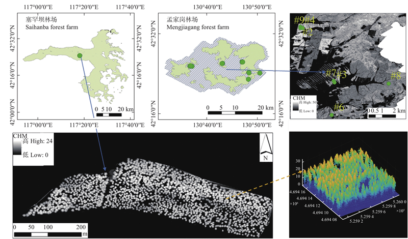
庞 勇, 梁晓军, 荚 文, 等. 塞罕坝林场机载综合遥感试验. 遥感学报, 2021, 25 (4): 904- 917.
doi: 10.11834/jrs.20210222
|
|
Pang Y, Liang X J, Jia W, et al. The comprehensive airborne remote sensing experiment in Saihanba forest farm. National Remote Sensing Bulletin, 2021, 25 (4): 904- 917.
doi: 10.11834/jrs.20210222
|
|
Ayrey E, Fraver S, Kershaw J A Jr, et al. Layer stacking: a novel algorithm for individual forest tree segmentation from LiDAR point clouds. Canadian Journal of Remote Sensing, 2017, 43 (1): 16- 27.
doi: 10.1080/07038992.2017.1252907
|
|
Dong T, Zhang X, Ding Z, et al. Multi-layered tree crown extraction from LiDAR data using graph-based segmentation. Computers and Electronics in Agriculture, 2020, 170, 105213.
doi: 10.1016/j.compag.2020.105213
|
|
Dubayah R, Blair J B, Goetz S, et al. The global ecosystem dynamics investigation: high-resolution laser ranging of the earth’s forests and topography. Science of Remote Sensing, 2020, 1, 100002.
doi: 10.1016/j.srs.2020.100002
|
|
Ferraz A, Bretar F, Jacquemoud S, et al. 3-D mapping of a multi-layered Mediterranean forest using ALS data. Remote Sensing of Environment, 2012, 121, 210.
doi: 10.1016/j.rse.2012.01.020
|
|
Gupta S, Weinacker H, Koch B. Comparative analysis of clustering-based approaches for 3-D single tree detection using airborne fullwave LiDAR data. Remote Sensing, 2010, 2 (4): 968- 989.
doi: 10.3390/rs2040968
|
|
Hamraz H, Contreras M A, Zhang J. Vertical stratification of forest canopy for segmentation of understory trees within small-footprint airborne LiDAR point clouds. ISPRS Journal of Photogrammetry and Remote Sensing, 2017, 130, 385- 392.
doi: 10.1016/j.isprsjprs.2017.07.001
|
|
Hu B, Li J, Jing L, et al. Improving the efficiency and accuracy of individual tree crown delineation from high-density LiDAR data. International Journal of Applied Earth Observation and Geoinformation, 2014, 26, 145- 155.
doi: 10.1016/j.jag.2013.06.003
|
|
Hyyppä J, Hyyppä H, Inkinen M, et al. Accuracy comparison of various remote sensing data sources in the retrieval of forest stand attributes. Forest Ecology and Management, 2000, 128 (1/2): 109- 120.
|
|
Jin S C, Su Y J, Gao S, et al. Deep learning: individual maize segmentation from terrestrial LiDAR data using faster R-CNN and regional growth algorithms. Frontiers in Plant Science, 2018, 22 (9): 866.
|
|
Kandare K, Ørka H O, Chan J C W, et al. Effects of forest structure and airborne laser scanning point cloud density on 3D delineation of individual tree crowns. European Journal of Remote Sensing, 2016, 49 (1): 337- 359.
doi: 10.5721/EuJRS20164919
|
|
Khosravipour A, Skidmore A K, Isenburg M. Generating spike-free digital surface models using LiDAR raw point clouds: a new approach for forestry applications. International Journal of Applied Earth Observation and Geoinformation, 2016, 52, 104- 114.
doi: 10.1016/j.jag.2016.06.005
|
|
Li W K, Guo Q H, Jakubowski M K, et al. A new method for segmenting individual trees from the LiDAR point cloud. Photogrammetric Engineering & Remote Sensing, 2012, 78 (1): 75- 84.
|
|
Lindberg E, Holmgren J. Individual tree crown methods for 3D data from remote sensing. Current Forestry Reports, 2017, 3 (1): 19- 31.
doi: 10.1007/s40725-017-0051-6
|
|
Morsdorf F, Meier E, Kötz B, et al. LIDAR-based geometric reconstruction of boreal type forest stands at single tree level for forest and wildland fire management. Remote Sensing of Environment, 2004, 92 (3): 353- 362.
doi: 10.1016/j.rse.2004.05.013
|
|
Næsset E. Predicting forest stand characteristics with airborne scanning laser using a practical two-stage procedure and field data. Remote Sensing of Environment, 2002, 80 (1): 88- 99.
doi: 10.1016/S0034-4257(01)00290-5
|
|
Pang Y, Li Z, Ju H, et al. LiCHy: The CAF’s LiDAR, CCD and hyperspectral integrated airborne observation system. Remote Sensing, 2016, 8 (5): 398.
doi: 10.3390/rs8050398
|
|
Pang Y, Wang W W, Du L M, et al. Nyström-based spectral clustering using airborne LiDAR point cloud data for individual tree segmentation. International Journal of Digital Earth, 2021, 14 (10): 1452- 1476.
doi: 10.1080/17538947.2021.1943018
|
|
Pitkänen J, Maltamo M, Hyyppä J, et al. 2004. Adaptive methods for individual tree detection on airborne laser based canopy height model. International Archives of Photogrammetry, Remote Sensing and Spatial Information Sciences, XXXVI-8/W2
|
|
Pu S, Rutzinger M, Vosselman G, et al. Recognizing basic structures from mobile laser scanning data for road inventory studies. ISPRS Journal of Photogrammetry and Remote Sensing, 2011, 66 (6): S28- S39.
doi: 10.1016/j.isprsjprs.2011.08.006
|
|
Reitberger J, Schnörr C, Krzystek P, et al. 3D segmentation of single trees exploiting full waveform LiDAR data. ISPRS Journal of Photogrammetry and Remote Sensing, 2009, 64 (6): 561- 574.
doi: 10.1016/j.isprsjprs.2009.04.002
|
|
Soille P. 2004. Morphological image analysis: principles and applications. New York: Springer, 201-204.
|
|
Tang F F, Zhang X H, Liu J N. 2007. Segmentation of tree crown model with complex structure from airborne LiDAR data. Geoinformatics 2007: Remotely Sensed Data and Information. Nanjing, China, SPIE, 6752(1): 67520A- 67520A- 9.
|
|
Wang J, Chen X, Cao L, et al. Individual rubber tree segmentation based on ground-based LiDAR data and faster R-CNN of deep learning. Forests, 2019, 10 (9): 793.
doi: 10.3390/f10090793
|
|
Zhao D, Pang Y, Li Z Y, et al. Isolating individual trees in a closed coniferous forest using small footprint LiDAR data. International Journal of Remote Sensing, 2014, 35 (20): 7199- 7218.
doi: 10.1080/01431161.2014.967886
|
|
Zimble D A, Evans D L, Carlson G C, et al. Characterizing vertical forest structure using small-footprint airborne LiDAR. Remote Sensing of Environment, 2003, 87 (2/3): 171- 182.
|