
Scientia Silvae Sinicae ›› 2026, Vol. 62 ›› Issue (4): 68-80.doi: 10.11707/j.1001-7488.LYKX20250309
• Research papers • Previous Articles Next Articles
Weisheng Zeng1,*( ),Xuexiang Wen1,Han Fu2,Xiangnan Sun1,Kangmei Lü3,Qiangyi Liu1,Tian Wang1
Received:2025-05-14
Online:2026-04-15
Published:2026-04-11
Contact:
Weisheng Zeng
E-mail:zengweisheng0928@126.com
CLC Number:
Weisheng Zeng,Xuexiang Wen,Han Fu,Xiangnan Sun,Kangmei Lü,Qiangyi Liu,Tian Wang. Establishment and Application of Simultaneous Models for Estimating Major Stand Characteristics in Beijing Based on LiDAR Data[J]. Scientia Silvae Sinicae, 2026, 62(4): 68-80.
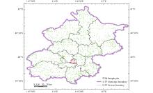
Fig.1
Map of the study area and distribution of sample plots"
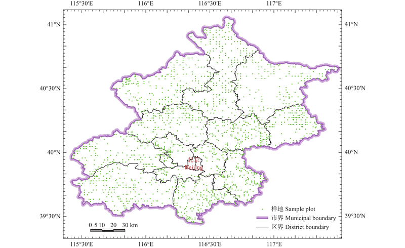
Table 1
Statistics of eight major stand factors for modeling plots"
| 特征数 Statistics | 平均胸径 Mean diameter at breast height (D)/cm | 平均高 Mean height (H)/m | 优势高 Dominant height (Hd)/m | 株数 Stem number (N)/ (tree·hm?2) | 断面积 Basal area (G)/(m2·hm?2) | 蓄积量 Stock volume (V)/(m3·hm?2) | 生物量 Biomass (B)/(t·hm?2) | 碳储量 Carbon storage (C)/ (t·hm?2) |
| 平均数Mean | 14.0 | 8.8 | 10.3 | 771 | 10.8 | 59.0 | 68.8 | 33.2 |
| 最小值Min. | 5.0 | 1.9 | 2.0 | 15 | 0.1 | 0.1 | 0.1 | 0.1 |
| 最大值Max. | 44.8 | 27.4 | 28.1 | 43.9 | 435.4 | 338.6 | 163.7 | |
| 标准差Standard deviation (SD) | 6.1 | 3.9 | 4.4 | 598 | 7.8 | 57.5 | 54.9 | 26.5 |
| 变动系数Coefficient of variation (CV)(%) | 43.6 | 44.2 | 42.4 | 77.6 | 72.8 | 97.4 | 79.7 | 79.7 |
Table 2
Parameter estimates of simultaneous models for 13 forest types"
| 森林类型 Forest type | 林分因子 Stand factor | 解释变量 Explanatory variable | 参数估计值Parameter estimates | ||||
| a0~g0 | a1~f1 | a2~c2 | a3~c3 | a4~c4 | |||
| 油松林 Pinus tabuliformis forest (n=200) | D | X1、X3、X5 | 10.213 0 | 0.202 2 | 0.187 6 | 0.037 8 | |
| Hd | X1、X3 | 2.238 1 | ?0.099 2 | 0.795 9 | |||
| G | X4、X5 | 2.433 3 | 0.586 0 | 0.663 5 | |||
| V | X1、X3、X5 | 11.427 0 | 0.690 2 | 0.364 9 | 0.682 1 | ||
| H | 0.031 7 | 0.836 1 | |||||
| B | 0.474 7 | 0.988 2 | |||||
| C | 0.509 3 | ||||||
| 侧柏林 Platycladus orientalis forest (n=100) | D | X1、X3、X5 | 4.912 8 | 0.679 5 | 0.271 0 | ?0.097 9 | |
| Hd | X1、X3 | 4.914 1 | 0.441 9 | 0.230 5 | |||
| G | X4、X5 | 0.684 0 | 1.470 0 | 0.473 1 | |||
| V | X4、X5 | 1.612 7 | 1.864 2 | 0.438 7 | |||
| H | ?0.149 7 | 0.861 4 | |||||
| B | 0.981 3 | 1.329 7 | |||||
| C | 0.484 3 | ||||||
| 针叶混交林 Coniferous mixed forest (n=100) | D | X1、X2、X5 | 4.100 4 | 0.396 0 | 0.313 4 | ?0.104 4 | |
| H | X2、X4 | 2.874 4 | 0.111 6 | 0.444 2 | |||
| G | X1、X5 | 2.128 2 | 1.039 6 | 0.472 6 | |||
| V | X1、X5 | 5.514 7 | 1.444 9 | 0.507 1 | |||
| Hd | 0.290 5 | 1.244 1 | |||||
| B | 2.441 4 | 1.180 1 | |||||
| C | 0.489 9 | ||||||
| 栎树林 Quercus spp. forest (n=200) | D | X2、X5 | 4.273 6 | 0.561 0 | ?0.124 6 | ||
| Hd | X2、X4 | 2.878 6 | 0.895 1 | ?0.346 7 | |||
| G | X3、X5 | 8.005 4 | 1.120 4 | 0.081 3 | |||
| V | X3、X4 | 22.55 7 | 1.185 6 | 0.305 7 | |||
| H | 0.345 2 | 0.767 9 | |||||
| B | 3.072 4 | 1.350 2 | |||||
| C | 0.480 3 | ||||||
| 桦木林 Betula spp. forest (n=88) | D | X1、X2 | 1.307 4 | ?0.229 7 | 1.121 6 | ||
| Hd | X2 | 2.197 8 | 0.707 4 | ||||
| G | X3、X4 | 1.013 2 | 0.121 3 | 1.253 8 | |||
| V | X3、X4 | 3.389 6 | 0.380 7 | 1.376 5 | |||
| H | 0.058 6 | 0.817 9 | |||||
| B | 3.776 8 | 1.098 0 | |||||
| C | 0.484 1 | ||||||
| 杨树林 Populus spp. forest (n=200) | D | X1、X2 | 3.925 5 | 0.110 7 | 0.572 5 | ||
| Hd | X2 | 5.228 9 | 0.446 9 | ||||
| G | X2 | 0.558 3 | 1.198 6 | ||||
| V | X2 | 2.066 6 | 1.495 0 | ||||
| H | ?0.582 8 | 0.926 8 | |||||
| B | 1.304 9 | 0.802 5 | |||||
| C | 0.472 5 | ||||||
| 榆树林 Ulmus spp. forest (n=100) | D | X2、X5 | 2.488 9 | 0.806 9 | ?0.031 4 | ||
| Hd | X2 | 2.129 4 | 0.744 5 | ||||
| G | X4、X5 | 0.446 3 | 1.428 0 | 0.161 8 | |||
| V | X4、X5 | 1.055 4 | 1.778 8 | 0.153 7 | |||
| H | ?0.133 1 | 0.871 9 | |||||
| B | 0.895 1 | 1.100 1 | |||||
| C | 0.449 4 | ||||||
| 刺槐林 Robinia pseudoacacia forest (n=100) | D | X2、X5 | 2.774 1 | 0.762 0 | ?0.033 7 | ||
| H | X2 | 2.952 8 | 0.566 8 | ||||
| G | X2 | 0.222 2 | 1.625 1 | ||||
| V | X2 | 0.772 8 | 1.838 0 | ||||
| Hd | 0.125 2 | 1.144 2 | |||||
| B | 1.434 7 | 1.341 0 | |||||
| C | 0.482 9 | ||||||
| 柳树林 Salix spp. forest (n=88) | D | X1、X2 | 1.296 6 | ?0.198 0 | 1.103 0 | ||
| H | X2 | 1.775 8 | 0.713 7 | ||||
| G | X3、X4 | 1.159 0 | 0.262 9 | 1.144 8 | |||
| V | X3、X4 | 4.007 4 | 0.501 8 | 1.259 7 | |||
| Hd | 0.027 6 | 1.216 7 | |||||
| B | 2.998 3 | 1.107 9 | |||||
| C | 0.484 2 | ||||||
| 乔木经济林 Economic forest of trees (n=90) | D | X3、X5 | 13.525 0 | 0.561 5 | ?0.105 3 | ||
| Hd | X3 | 8.457 3 | 0.369 2 | ||||
| G | X3 | 6.283 6 | 1.003 0 | ||||
| V | X3 | 24.672 0 | 1.225 4 | ||||
| H | 0.941 4 | 0.739 9 | |||||
| B | 2.849 4 | 1.782 5 | |||||
| C | 0.483 7 | ||||||
| 其他硬阔林 Other hard broad-leaved forest (n=300) | D | X2、X5 | 3.595 5 | 0.695 9 | ?0.010 3 | ||
| Hd | X2 | 2.870 8 | 0.594 4 | ||||
| G | X2、X4 | 0.389 2 | 0.323 5 | 1.297 2 | |||
| V | X2、X4 | 0.857 8 | 0.542 9 | 1.434 9 | |||
| H | 0.116 4 | 0.878 1 | |||||
| B | 2.198 5 | 1.512 5 | |||||
| C | 0.483 5 | ||||||
| 其他软阔林 Other soft broad-leaved forest (n=100) | D | X1、X2、X4、X5 | 2.268 1 | 0.644 6 | 1.380 1 | ?1.149 3 | ?0.106 3 |
| Hd | X2、X5 | 1.885 4 | 0.774 4 | ?0.071 5 | |||
| G | X2 | 0.102 6 | 2.060 6 | ||||
| V | X2 | 0.202 3 | 2.436 3 | ||||
| H | 0.460 6 | 0.796 8 | |||||
| B | 1.944 9 | 1.259 6 | |||||
| C | 0.480 8 | ||||||
| 阔叶混交林 Broad-leaved mixed forest (n=300) | D | X1、X2、X4、X5 | 2.860 9 | 0.242 6 | 1.044 8 | ?0.583 1 | ?0.131 5 |
| H | X2、X5 | 2.487 6 | 0.593 4 | ?0.037 7 | |||
| G | X1、X3、X5 | 2.400 7 | 0.722 5 | 0.676 3 | 0.225 8 | ||
| V | X1、X3、X5 | 7.772 3 | 0.923 4 | 0.899 9 | 0.206 3 | ||
| Hd | ?0.520 6 | 1.286 7 | |||||
| B | 4.350 3 | 1.181 6 | |||||
| C | 0.478 8 | ||||||
Table 3
The evaluation indexes of forest, coniferous forest and broadleaved forest models"
| 森林类型 Forest type | 林分因子 Stand factor | 自检结果Self-validation results | 交叉检验结果Cross-validation results | |||||||||||
| R2 | SEE | TRE | ASE | MPE | MPSE | R2 | SEE | TRE | ASE | MPE | MPSE | |||
| 森林 Forest | D | 0.731 | 3.20 | 1.97 | 1.75 | 1.01 | 15.52 | 0.715 | 3.27 | 2.05 | 2.05 | 1.03 | 15.88 | |
| H | 0.773 | 1.87 | 0.13 | ?0.71 | 0.94 | 15.27 | 0.760 | 1.91 | 0.13 | ?0.52 | 0.96 | 15.58 | ||
| Hd | 0.766 | 2.14 | 0.08 | ?0.88 | 0.92 | 15.79 | 0.755 | 2.18 | 0.18 | ?0.60 | 0.93 | 15.94 | ||
| G | 0.726 | 4.14 | 0.40 | 0.47 | 1.70 | 31.50 | 0.708 | 4.30 | 1.10 | 1.94 | 1.73 | 31.64 | ||
| N | 0.536 | 416 | 3.55 | 3.70 | 2.39 | 38.73 | 0.517 | 430 | 4.48 | 5.11 | 2.42 | 39.38 | ||
| V | 0.767 | 28.0 | 1.22 | ?2.43 | 2.10 | 34.28 | 0.752 | 28.9 | 1.61 | ?0.93 | 2.12 | 34.29 | ||
| B | 0.703 | 30.4 | ?0.30 | 0.90 | 1.95 | 34.38 | 0.684 | 31.7 | 0.28 | 2.38 | 1.99 | 34.49 | ||
| C | 0.701 | 14.7 | ?0.35 | 0.98 | 1.96 | 34.42 | 0.682 | 15.4 | 0.23 | 2.46 | 2.00 | 34.53 | ||
| 针叶林 Coniferous forest | D | 0.683 | 2.15 | 1.06 | 1.33 | 1.74 | 13.35 | 0.662 | 2.22 | 1.00 | 1.35 | 1.80 | 13.81 | |
| H | 0.752 | 1.44 | ?0.31 | ?1.55 | 2.01 | 14.19 | 0.733 | 1.49 | ?0.16 | ?1.32 | 2.08 | 14.55 | ||
| Hd | 0.723 | 1.84 | ?0.37 | ?1.81 | 2.12 | 15.80 | 0.705 | 1.89 | ?0.23 | ?1.58 | 2.18 | 16.10 | ||
| G | 0.839 | 3.22 | ?0.98 | 1.05 | 2.79 | 21.42 | 0.832 | 3.29 | ?1.13 | 0.99 | 2.84 | 21.58 | ||
| N | 0.538 | 368 | 2.85 | 4.45 | 3.83 | 31.05 | 0.511 | 379 | 2.83 | 4.81 | 3.95 | 31.83 | ||
| V | 0.837 | 23.6 | 1.49 | ?1.43 | 4.06 | 23.59 | 0.829 | 24.1 | 1.32 | ?1.36 | 4.16 | 23.88 | ||
| B | 0.806 | 22.4 | ?2.77 | 1.23 | 3.61 | 24.62 | 0.792 | 23.2 | ?3.01 | 1.25 | 3.73 | 25.05 | ||
| C | 0.808 | 11.2 | ?2.81 | 1.20 | 3.61 | 24.40 | 0.794 | 11.6 | ?3.05 | 1.22 | 3.74 | 24.82 | ||
| 阔叶林 Broadleaved forest | D | 0.727 | 3.41 | 2.17 | 1.85 | 1.17 | 16.07 | 0.712 | 3.49 | 2.28 | 2.23 | 1.19 | 16.41 | |
| H | 0.762 | 1.96 | 0.21 | ?0.50 | 1.06 | 15.55 | 0.748 | 2.01 | 0.18 | ?0.32 | 1.07 | 15.84 | ||
| Hd | 0.761 | 2.21 | 0.17 | ?0.64 | 1.01 | 15.79 | 0.749 | 2.24 | 0.26 | ?0.35 | 1.02 | 15.90 | ||
| G | 0.696 | 4.34 | 0.78 | 0.33 | 2.03 | 34.07 | 0.676 | 4.52 | 1.71 | 2.18 | 2.05 | 34.21 | ||
| N | 0.524 | 427 | 3.79 | 3.50 | 2.92 | 40.69 | 0.508 | 442 | 5.02 | 5.18 | 2.94 | 41.31 | ||
| V | 0.749 | 29.0 | 1.16 | ?2.68 | 2.42 | 37.01 | 0.732 | 30.0 | 1.68 | ?0.82 | 2.44 | 36.95 | ||
| B | 0.680 | 32.1 | 0.26 | 0.82 | 2.25 | 36.87 | 0.659 | 33.5 | 1.01 | 2.67 | 2.27 | 36.91 | ||
| C | 0.677 | 15.5 | 0.24 | 0.92 | 2.27 | 36.98 | 0.656 | 16.2 | 0.99 | 2.78 | 2.29 | 37.02 | ||
Fig.2
Fitting performance of forest volume, biomass, and carbon storage models"
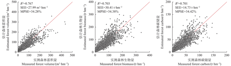
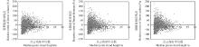
Fig.3
Distribution of relative errors of forest volume, biomass and carbon storage models"
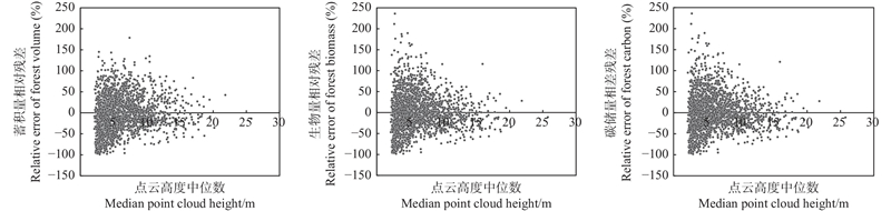

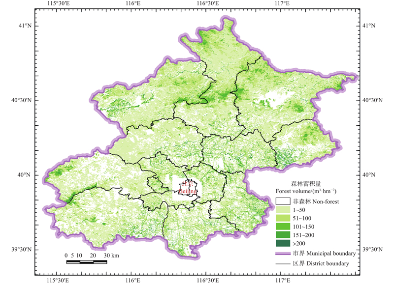
Fig.4
Distribution map of forest volume"
| 曹 林, 代劲松, 徐建新, 等. 基于机载小光斑LiDAR技术的亚热带森林参数信息优化提取. 北京林业大学学报, 2014, 36 (5): 13- 21. | |
| Cao L, Dai J S, Xu J X, et al. Optimized extraction of forest parameters in subtropical forests based on airborne small footprint LiDAR technology. Journal of Beijing Forestry University, 2014, 36 (5): 13- 21. | |
|
代华兵, 李春干, 庞 勇, 等. 基于天空地一体化森林资源调查的小班因子设置与信息获取方法. 林业资源管理, 2021, (1): 180- 188.
doi: 10.13466/j.cnki.lyzygl.2021.01.023 |
|
|
Dai H B, Li C G, Pang Y, et al. Method for sub-compartment investigation factors setting and information acquisition based on integrated aerial-space-ground forest inventory system. Forest Resources Management, 2021, (1): 180- 188.
doi: 10.13466/j.cnki.lyzygl.2021.01.023 |
|
|
丁志文, 邢艳秋, 尹伯卿, 等. 融合无人机和地基激光雷达点云数据估测单木结构参数. 森林工程, 2024, 40 (1): 142- 151.
doi: 10.3969/j.issn.1006-8023.2024.01.017 |
|
|
Ding Z W, Xing Y Q, Yin B Q, et al. Fusion of UAV and TLS LiDAR point cloud data for estimating individual tree structure parameters. Forest Engineering, 2024, 40 (1): 142- 151.
doi: 10.3969/j.issn.1006-8023.2024.01.017 |
|
| 范凤云. 2010,. 基于机载LiDAR和极化SAR数据的山区森林蓄积量估测方法研究. 北京: 中国林业科学研究院. | |
| Fan F Y. 2010,. Study on the estimation method of forest volume using airbrone LiDAR and polarimetric SAR over hilly region. Beijing: Chinese Academy of Forestry. [in Chinese] | |
| 付 甜. 2010,. 基于机载激光雷达的亚热带森林参数估测. 合肥: 安徽农业大学. | |
| Fu T. 2010,. Estimation of forest parameters based on airborne laser scanning in subtropical zone. Hefei: Anhui Agricultural University. [in Chinese] | |
|
雷宇宙, 毛学刚. 结合UAV-LiDAR和Sentinel-2的森林蓄积量估测. 森林工程, 2023, 39 (6): 46- 54.
doi: 10.3969/j.issn.1006-8023.2023.06.001 |
|
|
Lei Y Z, Mao X G. Integrating UAV-LiDAR and Sentinel-2 for growing stock volume estimation. Forest Engineering, 2023, 39 (6): 46- 54.
doi: 10.3969/j.issn.1006-8023.2023.06.001 |
|
| 李春干, 李 振. 机载激光雷达大区域亚热带森林参数估测的普适性模型式. 林业科学, 2021, 57 (10): 23- 35. | |
| Li C G, Li Z. Generalizing predictive models of sub-tropical forest inventory attributes using an area-based approach with airborne LiDAR data. Scientia Silvae Sinicae, 2021, 57 (10): 23- 35. | |
| 李苑鑫, 吴楚航, 邢艳秋. 基于地基激光雷达人工蒙古栎削度−二元材积方程的构建. 森林工程, 2025, 41 (1): 162- 173. | |
| Li Y X, Wu C H, Xing Y Q. Construction of a taper-binary volume equation for plantation Mongolian oak based on TLS data. Forest Engineering, 2025, 41 (1): 162- 173. | |
|
李增元, 刘清旺, 庞 勇. 激光雷达森林参数反演研究进展. 遥感学报, 2016, 20 (5): 1138- 1150.
doi: 10.13198/j.issn.1001-6929.2024.11.07 |
|
|
Li Z Y, Liu Q W, Pang Y. Review on forest parameters inversion using LiDAR. Journal of Remote Sensing, 2016, 20 (5): 1138- 1150.
doi: 10.13198/j.issn.1001-6929.2024.11.07 |
|
|
刘鲁霞, 庞 勇. 机载激光雷达和地基激光雷达林业应用现状. 世界林业研究, 2014, 27 (1): 49- 56.
doi: 10.13348/j.cnki.sjlyyj.2014.01.009 |
|
|
Liu L X, Pang Y. Applications of airborne laser scanning and terrestrial laser scanning to forestry. World Forestry Research, 2014, 27 (1): 49- 56.
doi: 10.13348/j.cnki.sjlyyj.2014.01.009 |
|
| 刘清旺, 谭炳香, 胡凯龙, 等. 机载激光雷达和高光谱组合系统的亚热带森林估测遥感试验. 高技术通讯, 2016, 26 (3): 264- 274. | |
| Liu Q W, Tan B X, Hu K L, et al. The remote sensing experiment on airborne LiDAR and hyperspectral integrated system for subtropical forest estimation. Chinese High Technology Letters, 2016, 26 (3): 264- 274. | |
| 庞 勇, 李增元. 基于机载激光雷达的小兴安岭温带森林组分生物量反演. 植物生态学报, 2012, 36 (10): 1095- 1105. | |
| Pang Y, Li Z Y. Inversion of biomass components of the temperate forest using airborne LiDAR technology in Xiaoxing’an Mountains, northeastern of China. Chinese Journal of Plant Ecology, 2012, 36 (10): 1095- 1105. | |
|
庞 勇, 李增元, 陈博伟, 等. 星载激光雷达森林探测进展及趋势. 上海航天, 2019, 36 (3): 20- 28.
doi: 10.19328/j.cnki.1006-1630.2019.03.003 |
|
|
Pang Y, Li Z Y, Chen B W, et al. Status and development of spaceborne LiDAR applications in forestry. Aerospace Shanghai, 2019, 36 (3): 20- 28.
doi: 10.19328/j.cnki.1006-1630.2019.03.003 |
|
| 薛春泉, 陈振雄, 杨加志, 等. 省市县一体化森林碳储量估测技术体系: 以广东省为例. 林业资源管理, 2022, (4): 157- 163. | |
| Xue C Q, Chen Z X, Yang J Z, et al. A provincial-municipal-county integrated forest carbon storage estimating technology system: take Guangdong Province as an example. Forest Resources Management, 2022, (4): 157- 163. | |
| 杨明星, 徐天蜀, 牛晓花, 等. 基于Sentinel-1A雷达影像的思茅松林蓄积量估测. 西部林业科学, 2019, 48 (2): 52- 58. | |
| Yang M X, Xu T S, Niu X H, et al. Estimation of Pinus kesiya var. langbianensis forest stock volume based on Sentinel-1A SAR image. Journal of West China Forestry Science, 2019, 48 (2): 52- 58. | |
|
袁钰娜, 彭道黎, 王 威, 等. 利用机载激光雷达技术估测东北林区典型针叶林的蓄积量. 应用生态学报, 2021, 32 (3): 836- 844.
doi: 10.13287/j.1001-9332.202103.001 |
|
|
Yuan Y N, Peng D L, Wang W, et al. Estimating standing stocks of the typical conifer stands in northeast China based on airborne LiDAR data. Chinese Journal of Applied Ecology, 2021, 32 (3): 836- 844.
doi: 10.13287/j.1001-9332.202103.001 |
|
|
曾伟生, 孙乡楠, 王六如, 等. 基于机载激光雷达数据估计林分蓄积量及平均高和断面积. 林业资源管理, 2020, (2): 79- 86.
doi: 10.13466/j.cnki.lyzygl.2020.02.013 |
|
|
Zeng W S, Sun X N, Wang L R, et al. Estimating forest volume, mean height and basal area based on airborne laser scanning data. Forest Resources Management, 2020, (2): 79- 86.
doi: 10.13466/j.cnki.lyzygl.2020.02.013 |
|
|
曾伟生, 孙乡楠, 王六如, 等. 基于激光雷达数据的东北林区航空林分材积表编制. 林业资源管理, 2021a, (1): 147- 155.
doi: 10.13466/j.cnki.lyzygl.2021.01.019 |
|
|
Zeng W S, Sun X N, Wang L R, et al. Developing aerial stand volume tables based on laser scanning data for forest region of northeast China. Forest Resources Management, 2021a, (1): 147- 155.
doi: 10.13466/j.cnki.lyzygl.2021.01.019 |
|
| 曾伟生, 孙乡楠, 王六如, 等. 基于机载激光雷达数据的森林蓄积量模型研建. 林业科学, 2021b, 57 (2): 31- 38. | |
| Zeng W S, Sun X N, Wang L R, et al. Development of forest stand volume models based on airborne laser scanning data. Scientia Silvae Sinicae, 2021b, 57 (2): 31- 38. | |
|
曾伟生, 孙乡楠, 王六如, 等. 东北林区10种主要森林类型的蓄积量、生物量和碳储量模型研建. 北京林业大学学报, 2021c, 43 (3): 1- 8.
doi: 10.12171/j.1000-1522.20200058 |
|
|
Zeng W S, Sun X N, Wang L R, et al. Developing stand volume, biomass and carbon stock models for ten major forest types in forest region of northeastern China. Journal of Beijing Forestry University, 2021c, 43 (3): 1- 8.
doi: 10.12171/j.1000-1522.20200058 |
|
| 曾伟生, 唐守正. 立木生物量方程的优度评价和精度分析. 林业科学, 2011a, 47 (11): 106- 113. | |
| Zeng W S, Tang S Z. Goodness evaluation and precision analysis of tree biomass equations. Scientia Silvae Sinicae, 2011a, 47 (11): 106- 113. | |
| 曾伟生, 唐守正. 2011b. 非线性模型对数回归的偏差校正及与加权回归的对比分析. 林业科学研究, 24(2): 137-143. | |
| Zeng W S, Tang S Z. 2011b. Bias correction in logarithmic regression and comparison with weighted regression for non-linear models. Forest Research, 24(2): 137-143. [in Chinese] | |
| 曾伟生, 杨学云, 孙乡楠, 等. 森林资源调查监测中各级储量数据的一体化方法研究. 林业资源管理, 2022, (4): 13- 19. | |
| Zeng W S, Yang X Y, Sun X N, et al. A study on integration of forest stock data at different levels in forest inventory and monitoring. Forest Resources Management, 2022, (4): 13- 19. | |
| 周相贝, 李春干, 代华兵, 等. 点云密度对机载激光雷达大区域亚热带森林参数估测精度的影响. 林业科学, 2023, 59 (9): 23- 33. | |
| Zhou X B, Li C G, Dai H B, et al. Effects of point cloud density on the estimation accuracy of large-area subtropical forest inventory attributes using airborne LiDAR data. Scientia Silvae Sinicae, 2023, 59 (9): 23- 33. | |
| 赵 峰, 李增元, 王韵晟, 等. 机载激光雷达(LiDAR)数据在森林资源调查中的应用综述. 遥感信息, 2008, 23 (1): 106- 110, 53. | |
| Zhao F, Li Z Y, Wang Y S, et al. The application of LiDAR data in forest. Remote Sensing Information, 2008, 23 (1): 106- 110, 53. | |
|
邹文涛, 曾伟生, 孙乡楠. 基于机载激光雷达数据估计主要森林参数联立模型. 中南林业调查规划, 2024, 43 (4): 32- 38.
doi: 10.16166/j.cnki.cn43-1095.2024.04.007 |
|
|
Zou W T, Zeng W S, Sun X N. Joint modeling for estimating major forest parameters based on airborne laser scanning data. Central South Forest Inventory and Planning, 2024, 43 (4): 32- 38.
doi: 10.16166/j.cnki.cn43-1095.2024.04.007 |
|
|
Bottalico F, Chirici G, Giannini R, et al. Modeling Mediterranean forest structure using airborne laser scanning data. International Journal of Applied Earth Observation and Geoinformation, 2017, 57, 145- 153.
doi: 10.1016/j.jag.2016.12.013 |
|
| Bouvier M, Durrieu S, Fournier R A, et al. Generalizing predictive models of forest inventory attributes using an area-based approach with airborne LiDAR data. Remote Sensing of Environment, 2015, 156 (1): 322- 334. | |
|
González-Ferreiro E, Diéguez-Aranda U, Miranda D. Estimation of stand variables in Pinus radiata D. Don plantations using different LiDAR pulse densities. Forestry, 2012, 85 (2): 281- 292.
doi: 10.1093/forestry/cps002 |
|
|
Hollaus M, Dorigo W, Wagner W, et al. Operational wide-area stem volume estimation based on airborne laser scanning and national forest inventory data. International Journal of Remote Sensing, 2009, 30 (19): 5159- 5175.
doi: 10.1080/01431160903022894 |
|
|
Holmgren J. Prediction of tree height, basal area and stem volume in forest stands using airborne laser scanning. Scandinavian Journal of Forest Research, 2004, 19 (6): 543- 553.
doi: 10.1080/02827580410019472 |
|
|
Holmgren J, Nilsson M, Olsson H. Estimation of tree height and stem volume on plots using airborne laser scanning. Forest Science, 2003, 49 (3): 419- 428.
doi: 10.1093/forestscience/49.3.419 |
|
|
Hyyppä J, Yu X W, Hyyppä H, et al. Advances in forest inventory using airborne laser scanning. Remote Sensing, 2012, 4 (5): 1190- 1207.
doi: 10.3390/rs4051190 |
|
|
MacLean G A, Krabill W B. Gross-merchantable timber volume estimation using an airborne LiDAR system. Canadian Journal of Remote Sensing, 1986, 12 (1): 7- 18.
doi: 10.1080/07038992.1986.10855092 |
|
|
Næsset E. Estimating timber volume of forest stands using airborne laser scanner data. Remote Sensing of Environment, 1997, 61 (2): 246- 253.
doi: 10.1016/S0034-4257(97)00041-2 |
|
| Penner M, Pitt D, Woods M. Parametric vs. nonparametric LiDAR models for operational forest inventory in boreal Ontario. Canadian Journal of Remote Sensing, 2013, 39 (5): 426- 443. | |
|
White J C, Coops N C, Wulder M A, et al. Remote sensing technologies for enhancing forest inventories: a review. Canadian Journal of Remote Sensing, 2016, 42 (5): 619- 641.
doi: 10.1080/07038992.2016.1207484 |
|
| Zhang Z N, Wang T J, Skidmore A K, et al. An improved area-based approach for estimating plot-level tree DBH from airborne LiDAR data. Forest Ecosystems, 2023, 10 (1): 100089. | |
|
Zörner J, Dymond J R, Shepherd J D, et al. LiDAR-based regional inventory of tall trees: Wellington, New Zealand. Forests, 2018, 9 (11): 702.
doi: 10.3390/f9110702 |
|
|
Zou W T, Zeng W S, Sun X N. Simultaneous models for the estimation of main forest parameters based on airborne LiDAR data. Forests, 2024, 15 (5): 775.
doi: 10.3390/f15050775 |
| [1] | Qingcheng Fu,Erfa Qiu,Yuan Zhang,Huichao Wang,Lanhong Huang. Characteristics and Influencing Factors of Heart Rot of Ancient Ginkgo biloba Trees in Beijing [J]. Scientia Silvae Sinicae, 2023, 59(6): 130-140. |
| [2] | Kuanbiao Qiu,Xiaoting Li,Junfeng Cheng,Baoquan Jia. Dynamics of Urban Tree Canopy Patches within the 6th Ring Road in Beijing Based on Morphological Spatial Pattern Analysis (MSPA) Method [J]. Scientia Silvae Sinicae, 2023, 59(5): 11-20. |
| [3] | Zexin Guo,Zhongyue Hu,Cong Cao,Ping Liu. Stand-Level Models of Biomass and Carbon Stock for Major Forest Types in Guangdong [J]. Scientia Silvae Sinicae, 2023, 59(12): 37-50. |
| [4] | Zanqing Zeng,Hanqing Song,Junhong Gao,Miaomiao Wang,Yaoxing Wu,Lianghua Qi. Spatial and Temporal Change and Potential Prediction of Carbon Sequestrating and Energy Carbon Emissing of Forest Vegetation in Beijing [J]. Scientia Silvae Sinicae, 2023, 59(12): 51-60. |
| [5] | Zihe Liu,Guodong Jia,Ziqiang Liu,Wenping Deng. Water Source Change of Platycladus orientalis under Different Water Regimes in Beijing Mountainous Area: a Multi-timescale Study [J]. Scientia Silvae Sinicae, 2022, 58(3): 40-47. |
| [6] | Xiaoting Li,Tong Li,Kuanbiao Qiu,Shasha Jiang,Baoquan Jia. Relationship between Patterns of Urban Forest Patches and Their Cooling Effects——A Case Study of Beijing Urban Area [J]. Scientia Silvae Sinicae, 2021, 57(4): 32-42. |
| [7] | Zhiyi Zhang,Lin Xin,Erfa Qiu,Xiaoyang Xie,Xinyu Wang,Zhenkai Sun,Shasha Jiang,Jiao Zhao. Scenic Beauty Estimation in Four Seasons of the Forest Belt along the Winter Olympics Expressway [J]. Scientia Silvae Sinicae, 2021, 57(12): 43-56. |
| [8] | Shaofeng Niu,Erfa Qiu,Zhiyi Zhang,Lu Xi. Changes of Diversity Gradient of Woody Plants Populations in Urban Riparian Forests of Beijing [J]. Scientia Silvae Sinicae, 2020, 56(11): 198-206. |
| [9] | Majie, Jia Baoquan. Diversity and Structural Characteristics of Woody Plants in the Greenbelt Attached to Urban Roads in the Sixth Ring Road of Beijing [J]. Scientia Silvae Sinicae, 2019, 55(4): 13-21. |
| [10] | Jia Baoquan, Qiu Kuanbiao. Urban Tree Canopy(UTC)Dynamics and Changes of Landscape Patterns in the Second Green Belt in Beijing from 2002 to 2013 [J]. Scientia Silvae Sinicae, 2019, 55(2): 13-21. |
| [11] | Zeng Weisheng, He Dongbei, Pu Ying, Xiao Qianhui. Individual Tree Biomass and Volume Equation System with Region and Origin in Variables for Pinus massoniana in China [J]. Scientia Silvae Sinicae, 2019, 55(2): 75-86. |
| [12] | Zhang Yuanchen, Su Shanyu, Liu Ping, Zhang Yuxiao, Zhang Kunpeng, Wang Jingshun. Survey of Natural Enemies in Gall of Trichagalma acutissimae (Hymenoptera: Cynipidae) and Biological of Its Predominant Parasitoids [J]. Scientia Silvae Sinicae, 2019, 55(2): 137-142. |
| [13] | Xiuping Liu,Baoquan Jia. Characterization of Tree Canopy in Urban Residential Areas of Beijing [J]. Scientia Silvae Sinicae, 2019, 55(12): 12-20. |
| [14] | Weisheng Zeng,Xinyun Chen,Xueyun Yang. Biomass Modeling and Productivity Analysis of Planted Populus spp. in China [J]. Scientia Silvae Sinicae, 2019, 55(11): 1-8. |
| [15] | Liu Ziqiang, Yu Xinxiao, Jia Guodong, Li Hanzhi, Lu Weiwei, Hou Guirong. Response to Precipitation in Water Sources for Platycladus orientalis in Beijing Mountain Area [J]. Scientia Silvae Sinicae, 2018, 54(7): 16-23. |
| Viewed | ||||||
|
Full text |
|
|||||
|
Abstract |
|
|||||