
林业科学 ›› 2023, Vol. 59 ›› Issue (12): 1-12.doi: 10.11707/j.1001-7488.LYKX20230172
• 前沿与重点:典型树种空间分布的气候变化响应与适应 • 上一篇 下一篇
王亚1,王军辉1,王福德3,刘逸夫2,谭灿灿2,袁艳超2,聂稳2,刘建锋1,常二梅1,贾子瑞1,*( )
)
收稿日期:2023-04-27
出版日期:2023-12-25
发布日期:2024-01-08
通讯作者:
贾子瑞
E-mail:.jiazirui646@163.com
基金资助:
Ya Wang1,Junhui Wang1,Fude Wang3,Yifu Liu2,Cancan Tan2,Yanchao Yuan2,Wen Nie2,Jianfeng Liu1,Ermei Chang1,Zirui Jia1,*()
Received:2023-04-27
Online:2023-12-25
Published:2024-01-08
Contact:
Zirui Jia
E-mail:.jiazirui646@163.com
摘要:
目的: 探究红皮云杉地理分布格局与气候变化的关系,模拟红皮云杉在不同时期气候变化下的潜在适生分布区,为红皮云杉的资源管理和多样性保护提供科学依据。方法: 基于我国红皮云杉59个现有分布点数据和Worldclim网站下载的19个气候变量,采用最大熵模型(MaxEnt),模拟红皮云杉在现代、末次间冰期(LIG)、末次盛冰期(LGM)、全新世中期(MH)以及未来2个时期(2050s和2070s)2种排放气候场景(RCP4.5和RCP8.5)下的适生分布区,分析限制红皮云杉地理分布的主要环境因子,推测其生物避难所,预测其在未来气候变化情景下的变化趋势。结果: MaxEnt预测结果可靠,训练数据集和测试数据集的平均AUC均大于0.99,具有极高可信度。最暖季度降水量(Bio18)、气温季节性变动系数(Bio4)和降水量季节性变化(Bio15)是限制红皮云杉地理分布的主要变量,贡献率分别为40.6%、28.9%和24.6%。红皮云杉当前适生区包括中国的大兴安岭、小兴安岭、长白山地区;红皮云杉在LIG、LGM和MH时期的适生区面积分别为当前的102.59%,105.20%和100.53%;从末次盛冰期到现代,其分布中心具有向东南、再向东北、再向西南的迁移趋势。未来气候情景下红皮云杉的适生区面积呈减少趋势,RCP4.5-2050s、RCP4.5-2070s、RCP8.5-2050s和RCP8.5-2070s情景下的适生区面积分别为当前时期的99.06%、96.88%、98.05%和95.08%,高适生区边缘呈片段化分布,小兴安岭腹地和长白山腹地的种群较为稳定。结论: 相对于温度,降水对红皮云杉地理分布的影响更重要。红皮云杉在末次盛冰期发生种群扩张,从全新世中期到现代其种群持续收缩。通过种群遗传多样性、适生区预测和孢粉化石等推测长白山腹地和小兴安岭腹地是红皮云杉的间冰期避难所。未来气候情景下,红皮云杉适生区面积缩小,其分布中心有向高海拔和高纬度地区迁移的趋势,应考虑优先保护大兴安岭北部到中部、长白山西部和张广才岭北部等高适生区的边缘种群。
中图分类号:
王亚,王军辉,王福德,刘逸夫,谭灿灿,袁艳超,聂稳,刘建锋,常二梅,贾子瑞. 末次间冰期以来及未来气候情景下红皮云杉适生分布区模拟[J]. 林业科学, 2023, 59(12): 1-12.
Ya Wang,Junhui Wang,Fude Wang,Yifu Liu,Cancan Tan,Yanchao Yuan,Wen Nie,Jianfeng Liu,Ermei Chang,Zirui Jia. Simulation of Suitable Distribution Areas of Picea koraiensis in China Since the Last Interglacial and Under Future Climate Scenarios[J]. Scientia Silvae Sinicae, 2023, 59(12): 1-12.
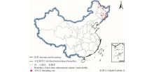
图1
当前红皮云杉在中国的分布记录"
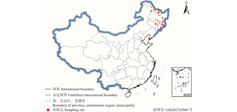
图2
基于MaxEnt模型预测红皮云杉分布的受试者工作特征曲线"
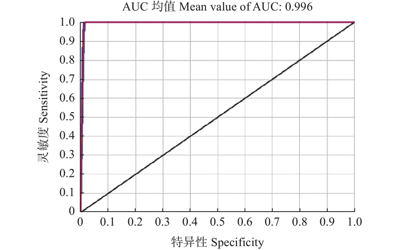
表1
影响红皮云杉适生分布的环境变量贡献百分率"
| 代码 Code | 环境变量 Environmental variable | 贡献率 Percent contribution (%) | 排列重要性 Permutation importance (%) |
| Bio18 | 最暖季度降水量Precipitation of warmest quarter | 40.6 | 36.3 |
| Bio4 | 气温季节性变动系数Temperature seasonality | 28.9 | 5.8 |
| Bio15 | 降水量季节性变化Precipitation seasonality | 24.6 | 0.3 |
| Bio1 | 年均气温Annual mean temperature | 4 | 1.3 |
| Bio17 | 最干季度降水量Precipitation of driest quarter | 1.5 | 55.7 |
| Bio3 | 等温性Isothermality | 0.4 | 0.5 |
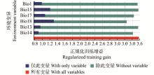
图3
环境变量刀切法检验"


图4
红皮云杉对重要环境变量的响应曲线"
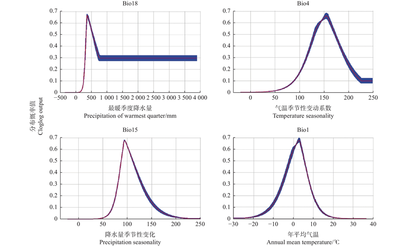
图5
当代、过去和未来气候情景下红皮云杉在中国适生分布区"
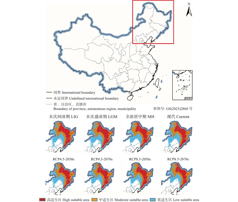
表2
红皮云杉在多种气候条件下的适生面积①"
| 气候情景 Climates scenarios | 总适生区 Total suitable area | 低适生区 Low suitable area | 中适生区 Moderate suitable area | 高适生区 High suitable area | |||||||
| 面积 Area/104 km2 | 比率 Ratio (%) | 面积 Area/104 km2 | 比率 Ratio (%) | 面积 Area/104 km2 | 比率 Ratio (%) | 面积 Area/104 km2 | 比率 Ratio (%) | ||||
| 1970—2000 | 133.58 | 100 | 40.93 | 100 | 42.36 | 100 | 50.29 | 100 | |||
| LIG | 137.04 | 102.59 | 43.40 | 106.03 | 41.20 | 97.26 | 52.44 | 104.28 | |||
| LGM | 140.52 | 105.20 | 46.10 | 112.63 | 40.25 | 95.02 | 54.18 | 107.74 | |||
| MH | 134.29 | 100.53 | 40.71 | 99.46 | 41.17 | 97.19 | 52.40 | 104.20 | |||
| 2050-RCP4.5 | 132.32 | 99.06 | 39.49 | 96.48 | 43.31 | 102.24 | 49.52 | 98.47 | |||
| 2070-RCP4.5 | 129.41 | 96.88 | 38.74 | 94.65 | 42.91 | 101.30 | 47.76 | 94.97 | |||
| 2050-RCP8.5 | 130.98 | 98.05 | 39.52 | 96.56 | 43.19 | 101.96 | 48.27 | 95.98 | |||
| 2070-RCP8.5 | 127.01 | 95.08 | 35.06 | 85.66 | 44.41 | 104.84 | 47.54 | 94.53 | |||
图6
不同时期红皮云杉适生区质心的迁移路线"
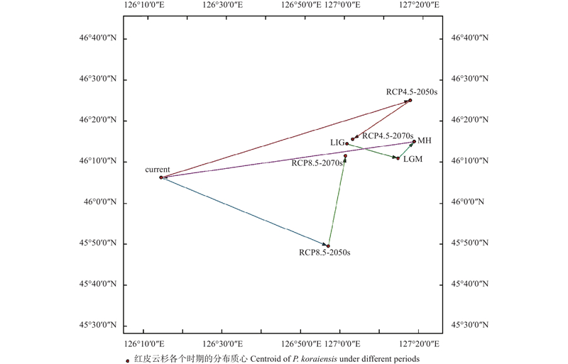
表3
不同时期红皮云杉适生区质心坐标和迁徙距离①"
| 物种 Species | 时期 Period | 经度 Longtitude | 纬度 Latitude | 距离 Distance/km | 方向 Direction |
| 红皮云杉 Picea koraiensis | LIG | 127°1'46.92''E | 46°14'27.38''N | ||
| LGM | 127°14'49.34''E | 46°10'54.01''N | 21.62 | 东南Southeast | |
| MH | 127°18'54.83''E | 46°15'0.44''N | 8.96 | 东北Northeast | |
| CUR | 126°14'28.81''E | 46°6'14.27''N | 104.43 | 西南Southwest | |
| RCP4.5-2050s | 127°17'54.03''E | 46°25'2.47''N | 105.72 | 东北Northeast | |
| RCP4.5-2070s | 127°3'15.60''E | 46°15'33.81''N | 27.40 | 西南Southwest | |
| RCP8.5-2050s | 126°57'0.64''E | 45°49'27.43''N | 72.81 | 东南Southeast | |
| RCP8.5-2070s | 127°1'25.55''E | 46°11'31.04''N | 33.56 | 东北Northeast |
| 安芷生, 艾 莉. 尚未完成的地质年代表: 第四纪悬而未决的前程. 地层学杂志, 2005, 29 (2): 99- 103. | |
| An Z S, Ai L. Imperfect geologic time scale: pending future of the quaternary. Journal of Stratigraphy, 2005, 29 (2): 99- 103. | |
| 戴旻峻, 李鑫玉, 王敏求, 等. 柳杉潜在适生区预测及气候变化对其分布的影响. 西北林学院学报, 2022, 37 (6): 26- 33. | |
| Dai M J, Li X Y, Wang M Q, et al. Potentially suitable area of Cryptomeria japonica var. sinensis and the influence of climate changes on its distribution. Journal of Northwest Forestry University, 2022, 37 (6): 26- 33. | |
| 段国珍. 2019. 沙地云杉及其近缘种的生态位分化与群体遗传学研究. 呼和浩特: 内蒙古农业大学. | |
| Duan G Z. 2019. Ecological divergence and population genetics of Picea mongolica and its related species. Hohhot: Inner Mongolia Agricultural University.[in Chinese] | |
| 段义忠, 鱼 慧, 王海涛, 等. 孑遗濒危植物四合木(Tetraena mongolica)的地理分布与潜在适生区预测. 植物科学学报, 2019, 37 (3): 337- 347. | |
| Duan Y Z, Yu H, Wang H T, et al. Geographical distribution and prediction of potentially suitable regions of endangered relict plant Tetraena mongolica. Plant Science Journal, 2019, 37 (3): 337- 347. | |
| 樊祺诚, 赵勇伟, 陈生生, 等. 2015. 大兴安岭-太行山重力梯度带以西的第四纪火山活动. 矿物岩石地球化学通报, 34(4): 674−681. | |
| Fan Q C, Zhao Y W, Chen S S, et al. 2015. Quaternary volcanic activities in the west of the Daxing'anling-Taihangshan gravity lineament. Bulletin of Mineralogy, Petrology and Geochemistry, 34(4): 674−681.[in Chinese] | |
| 高文强, 王小菲, 江泽平, 等. 气候变化下栓皮栎潜在地理分布格局及其主导气候因子. 生态学报, 2016, 36 (14): 4475- 4484. | |
| Gao W Q, Wang X F, Jiang Z P et al. Impact of climate change on the potential geographical distribution pattern and dominant climatic factors of Quercus variabilis. Acta Ecologica Sinica, 2016, 36 (14): 4475- 4484. | |
| 何 韬. 2019. 末次盛冰期全球冰盖变化的模拟对比与评估. 南京: 南京师范大学. | |
| He T. 2019. A dissertation submitted in partial fulfillment of the requirements for the degree of master of science. Nanjing: Nanjing Normal University.[in Chinese] | |
| 胡忠俊, 张镱锂, 刘林山, 等. 生物避难所及其识别方法评述. 生态学杂志, 2013, 32 (12): 3397- 3406. | |
| Hu Z J, Zhang Y L, Liu L S, et al. Refugia and their identification methods: a review. Chinese Journal of Ecology, 2013, 32 (12): 3397- 3406. | |
| 姜兴林, 高宪林, 李英俊, 等. 红皮云杉群体矿质营养特征的多样性. 东北林业大学学报, 2002, 30 (1): 24- 29. | |
| Jiang X L, Gao X L, Li Y J, et al. Character diversity of mineral nutrition of koyama spruce populations. Journal of Northeast Forestry University, 2002, 30 (1): 24- 29. | |
|
李国庆, 刘长成, 刘玉国, 等. 物种分布模型理论研究进展. 生态学报, 2013, 33 (16): 4827- 4835.
doi: 10.5846/stxb201212031735 |
|
|
Li G Q, Liu C C, Liu Y G, et al. Advances in theoretical issues of species distribution models. Acta Ecologica Sinica, 2013, 33 (16): 4827- 4835.
doi: 10.5846/stxb201212031735 |
|
| 刘 超, 霍宏亮, 田路明, 等. 不同气候情景下木梨潜在地理分布格局变化的预测. 应用生态学报, 2020, 31 (12): 4073- 4079. | |
| Liu C, Huo H L, Tian L M, et al. Prediction of potential geographical distribution patterns of Pyrus xerophila under different climate scenarios. Chinese Journal of Applied Ecology, 2020, 31 (12): 4073- 4079. | |
| 刘建强, 陈立辉, 钟 源, 等. 小兴安岭逊克地区第四纪高镁安山岩的岩石学、K-Ar年代学及火山地质特征. 岩石学报, 2017, 33 (1): 31- 40. | |
| Liu J Q, Chen L H, Zhong Y, et al. Petrological, K-Ar chronological and volcanic geological characteristics of Quaternary Xunke high-Mg# andesites from the Lesser Khingan Range. Acta Petrologica Sinica, 2017, 33 (1): 31- 40. | |
| 刘 想, 龚 熹, 陈思斯, 等. 基于MaxEnt和ArcGIS模拟檫木分布格局及其栖息地的变化. 植物科学学报, 2018, 36 (3): 320- 326. | |
| Liu X, Gong X, Chen S S, et al. Simulation of the distribution pattern of Sassafras tzumu and changes in habitat based on ArcGIS and MaxEnt. Plant Science Journal, 2018, 36 (3): 320- 326. | |
| 石 宁. 上新世-早更新世云杉属和冷杉属在华北地区的发展及其气候指示意义. 第四纪研究, 1996, 16 (4): 319- 328. | |
| Shi N. Development of spruce and fir in North China during the Pliocene and the early Pleistocene: palaeoclimatic implications. Quaternary Sciences, 1996, 16 (4): 319- 328. | |
| 石 甜. 2021. 薤白的遗传分化及地理分布格局形成研究. 贵阳: 贵州大学. | |
| Shi T. 2021. Study on genetic differentiation and formation of geographical distribution pattern of Allium macrostemon. Guiyang: Guizhou University.[in Chinese] | |
|
孙广友, 王海霞, 范 宇. 中国东北第四纪冰川研究新进展: 遗迹厘定、新发现与冰期模式. 地球科学与环境学报, 2012, 34 (1): 55- 65.
doi: 10.3969/j.issn.1672-6561.2012.01.008 |
|
|
Sun G Y, Wang H X, Fan Y. New advance on Quaternary glacier in Northeast China: remains examination, new discovery and ice epoch model. Journal of Earth Sciences and Environment, 2012, 34 (1): 55- 65.
doi: 10.3969/j.issn.1672-6561.2012.01.008 |
|
| 孙荣喜. 2017. 中国枫香树遗传多样性及谱系地理研究. 北京: 中国林业科学研究院. | |
| Sun R X. 2017. Genetic diversity and phylogeography of Liquidambar formosana Hance in China. Beijing: Chinese Academy of Forestry.[in Chinese] | |
| 王东升, 赵 伟, 程蓓蓓, 等. 基于MaxEnt模型的中国山楂潜在适生区. 林业科学, 2022, 58 (7): 43- 50. | |
| Wang D S, Zhao W, Cheng B B, et al. Potential suitable areas of Crataegus pinnatifida in China based on MaxEnt modeling. Scientia Silvae Sinicae, 2022, 58 (7): 43- 50. | |
| 王改妮. 2018. 云杉属四个近缘物种分化的群体遗传学研究. 兰州: 兰州大学. | |
| Wang G N. 2018. Population genetics study on differentiation of four related species of Picea. Lanzhou: Lanzhou University.[in Chinese] | |
|
王 欢, 徐 华, 王锡魁. 小兴安岭与松辽盆地新生代耦合关系. 世界地质, 2018, 37 (3): 804- 812.
doi: 10.3969/j.issn.1004-5589.2018.03.012 |
|
|
Wang H, Xu H, Wang X K. Coupling relationship between lesser khingan range and Songliao Basin in Cenozoic. Global Geology, 2018, 37 (3): 804- 812.
doi: 10.3969/j.issn.1004-5589.2018.03.012 |
|
|
王秋玉, 任旭琴, 姜 静. 红皮云杉地理种源遗传多样性的RAPD分析. 东北林业大学学报, 2004, 32 (6): 1- 3.
doi: 10.3969/j.issn.1000-5382.2004.06.001 |
|
|
Wang Q Y, Ren X Q, Jiang J. Genetic diversity for the provenance of Picea koraiensis by RAPD markers. Journal of Northeast Forestry University, 2004, 32 (6): 1- 3.
doi: 10.3969/j.issn.1000-5382.2004.06.001 |
|
| 王团华. 2006. 长白山区图们江流域新生代火山活动及其构造意义. 北京: 中国地震局地质研究所. | |
| Wang T H. 2006. Genzoic volcanic activity and its tectonic significance in the Tumen river field, Changbai Mountains area, Jilin Province, Northeast China. Beijing: Institute of Geology, China Earthquake Administrator.[in Chinese] | |
| 韦洁敏. 2020. 基于Maxent的附子潜在分布区预测及影响有效成分的环境因子分析. 延安: 延安大学. | |
| Wei J M. 2020. Prediction of potential distribution area of Aconitum carmichaeli Debx. based on Maxent model and analysis of environmental factors affecting effective components. Yan’an: Yan’an University.[in Chinese] | |
| 杨启杰, 李 睿. 桫椤的潜在适生区及其变化. 应用生态学报, 2021, 32 (2): 538- 548. | |
| Yang Q J, Li R. Predicting the potential suitable habitats of Alsophila spinulosa and their changes. Chinese Journal of Applied Ecology, 2021, 32 (2): 538- 548. | |
| 张爱平, 王 毅, 熊勤犁, 等. 末次间冰期以来3种云杉属植物的历史分布变迁及避难所. 应用生态学报, 2018, 29 (7): 2411- 2421. | |
| Zhang A P, Wang Y, Xiong Q L, et al. Distribution changes and refugia of three spruce taxa since the last interglacial. Chinese Journal of Applied Ecology, 2018, 29 (7): 2411- 2421. | |
|
张含国, 孙立夫, 韩继凤, 等. 红皮云杉群体遗传多样的研究. 植物研究, 2003, 23 (2): 224- 229.
doi: 10.3969/j.issn.1673-5102.2003.02.026 |
|
|
Zhang H G, Sun L F, Han J F, et al. Study on the genetic diversity of Picea koraiensis. Bulletin of Botanical Research, 2003, 23 (2): 224- 229.
doi: 10.3969/j.issn.1673-5102.2003.02.026 |
|
| 张文秀. 2020. 濒危植物金钱松核苷酸多样性与适宜分布区研究. 南昌: 江西农业大学. | |
| Zhang W X. 2020. Nucleotide diversity and suitable distribution of an endangered species Pseudolarix amabilis (Nelson) Rehd. (Pinaceae). Nanchang: Jiangxi Agricultural University.[in Chinese] | |
|
赵光华, 崔馨月, 王 智, 等. 气候变化背景下我国酸枣潜在适生区预测. 林业科学, 2021, 57 (6): 158- 168.
doi: 10.11707/j.1001-7488.20210618 |
|
|
Zhao G H, Cui X Y, Wang Z, et al. Prediction of potential distribution of Ziziphus jujuba var. spinosa in China under context of climate change. Scientia Silvae Sinicae, 2021, 57 (6): 158- 168.
doi: 10.11707/j.1001-7488.20210618 |
|
|
朱耿平, 刘国卿, 卜文俊, 等. 生态位模型的基本原理及其在生物多样性保护中的应用. 生物多样性, 2013, 21 (1): 90- 98.
doi: 10.3724/SP.J.1003.2013.09106 |
|
|
Zhu G P, Liu G Q, Bu W J, et al. Ecological niche modeling and its applications in biodiversity conservation. Biodiversity Science, 2013, 21 (1): 90- 98.
doi: 10.3724/SP.J.1003.2013.09106 |
|
|
朱耿平, 乔慧捷. Maxent 模型复杂度对物种潜在分布区预测的影响. 生物多样性, 2016, 24 (10): 1189- 1196.
doi: 10.17520/biods.2016265 |
|
|
Zhu G P, Qiao H J. Effect of the MaxEnt model’s complexity on the prediction of species potential distributions. Biodiversity Science, 2016, 24 (10): 1189- 1196.
doi: 10.17520/biods.2016265 |
|
|
邹 旭, 彭 冶, 王 璐, 等. 末次盛冰期以来气候变化对中国山荆子分布格局的影响. 植物科学学报, 2018, 36 (5): 676- 686.
doi: 10.11913/PSJ.2095-0837.2018.50676 |
|
|
Zou X, Peng Y, Wang L, et al. Impact of climate change on the distribution pattern of Malus baccata (L.) Borkh. in China since the Last Glacial Maximum. Plant Science Journal, 2018, 36 (5): 676- 686.
doi: 10.11913/PSJ.2095-0837.2018.50676 |
|
|
Abdelaal M, Fois M, Fenu G, et al. Using MaxEnt modeling to predict the potential distribution of the endemic plant Rosa Arabica Crép. in Egypt. Ecological Informatics, 2019, 50, 68- 75.
doi: 10.1016/j.ecoinf.2019.01.003 |
|
|
Abeli T, Dalrymple S, Godefroid S, et al. Ex situ collections and their potential for the restoration of extinct plants. Conservation Biology, 2020, 34 (2): 303- 313.
doi: 10.1111/cobi.13391 |
|
| Aguilar-Soto V, Melgoza-Castillo A, Villarreal-Guerrero F, et al. Modeling the potential distribution of Picea chihuahuana martínez, an endangered species at the sierra madre occidental, Mexico. Forests, 2015, 6 (3): 692- 707. | |
|
Allouche O, Tsoar A, Kadmon R. Assessing the accuracy of species distribution models: prevalence, kappa and the true skill statistic (TSS). Journal of Applied Ecology, 2006, 43 (6): 1223- 1232.
doi: 10.1111/j.1365-2664.2006.01214.x |
|
|
An Z S, Kutzbach J E, Prelli W L, et al. Evolution of Asian monsoons and phased uplift of the Himalaya-Tibetan Plateau since Late Miocene times. Nature, 2001, 411 (6833): 62- 66.
doi: 10.1038/35075035 |
|
|
Arar A, Nouidjem Y, Bounar R, et al. Potential future changes of the geographic range size of Juniperus phoenicea in Algeria based on present and future climate change projections. Contemporary Problems of Ecology, 2020, 13 (4): 429- 441.
doi: 10.1134/S1995425520040022 |
|
|
Ashcroft M B, French K O, Chisholm L A. An evaluation of environmental factors affecting species distributions. Ecological Modelling, 2011, 222 (3): 524- 531.
doi: 10.1016/j.ecolmodel.2010.10.003 |
|
| Bannister P, Neuner G. 2001. Frost resistance and the distribution of conifers.Tree Physiology.Dordrecht:Springer Netherlands, 3-21. | |
|
Bertrand B, Boulanger R, Dussert S, et al. Climatic factors directly impact the volatile organic compound fingerprint in green Arabica coffee bean as well as coffee beverage quality. Food Chemistry, 2012, 135 (4): 2575- 2583.
doi: 10.1016/j.foodchem.2012.06.060 |
|
|
Brown J L. SDM toolbox: a python-based GIS toolkit for landscape genetic, biogeographic and species distribution model analyses. Methods in Ecology and Evolution, 2014, 5 (7): 694- 700.
doi: 10.1111/2041-210X.12200 |
|
|
Carnaval A C, Moritz C. Historical climate modelling predicts patterns of current biodiversity in the Brazilian Atlantic forest. Journal of Biogeography, 2008, 35 (7): 1187- 1201.
doi: 10.1111/j.1365-2699.2007.01870.x |
|
|
Cobos M E, Peterson A T, Barve N, et al. Kuenm: an R package for detailed development of ecological niche models using Maxent. PeerJ, 2019, 7, e6281.
doi: 10.7717/peerj.6281 |
|
|
De Cauwer V, Muys B, Revermann R, et al. Potential, realised, future distribution and environmental suitability for Pterocarpus angolensis DC in southern Africa. Forest Ecology and Management, 2014, 315, 211- 226.
doi: 10.1016/j.foreco.2013.12.032 |
|
|
Deng M, Jiang X L, Hipp A L, et al. Phylogeny and biogeography of East Asian evergreen oaks (Quercus Section Cyclobalanopsis; Fagaceae): insights into the Cenozoic history of evergreen broad-leaved forests in subtropical Asia. Molecular Phylogenetics and Evolution, 2018, 119, 170- 181.
doi: 10.1016/j.ympev.2017.11.003 |
|
|
Elith J, Kearney M, Phillips S. The art of modelling range-shifting species. Methods in Ecology and Evolution, 2010, 1 (4): 330- 342.
doi: 10.1111/j.2041-210X.2010.00036.x |
|
|
Faleiro F V, Machado R B, Loyola R D. Defining spatial conservation priorities in the face of land-use and climate change. Biological Conservation, 2013, 158, 248- 257.
doi: 10.1016/j.biocon.2012.09.020 |
|
|
Fick S E, Hijmans R J. WorldClim 2: new 1-km spatial resolution climate surfaces for global land areas. International Journal of Climatology, 2017, 37 (12): 4302- 4315.
doi: 10.1002/joc.5086 |
|
|
Fourcade Y, Besnard A G, Secondi J. Paintings predict the distribution of species, or the challenge of selecting environmental predictors and evaluation statistics. Global Ecology and Biogeography, 2018, 27 (2): 245- 256.
doi: 10.1111/geb.12684 |
|
|
Guo Y L, Wei H Y, Lu C Y, et al. Predictions of potential geographical distribution and quality of Schisandra sphenanthera under climate change. PeerJ, 2016, 4, e2554.
doi: 10.7717/peerj.2554 |
|
|
Li J J, Fan G, He Y. Predicting the current and future distribution of three Coptis herbs in China under climate change conditions, using the MaxEnt model and chemical analysis. Science of the Total Environment, 2020, 698, 134141.
doi: 10.1016/j.scitotenv.2019.134141 |
|
|
Merow C, Smith M J, Silander Jr J A. A practical guide to MaxEnt for modeling species' distributions: what it does, and why inputs and settings matter. Ecography, 2013, 36 (10): 1058- 1069.
doi: 10.1111/j.1600-0587.2013.07872.x |
|
| Parmesan C. 2006. Ecological and evolutionary responses to recent climate change. Annual Review of Ecology, Evolution, and Systematics, 37: 637−669. | |
| Phillips S J, Anderson R P, Schapire R E. Maximum entropy modeling of species geographic distributions. Ecological Modelling, 2006, 190 (3/4): 231- 259. | |
|
Pinedo-Alvarez C, Renteria-Villalobos M, Aguilar-Soto V, et al. Distribution dynamics of Picea chihuahuana Martínez populations under different climate change scenarios in Mexico. Global Ecology and Conservation, 2019, 17, e00559.
doi: 10.1016/j.gecco.2019.e00559 |
|
|
Shao C C, Shen T T, Jin W T, et al. Phylotranscriptomics resolves interspecific relationships and indicates multiple historical out-of-North America dispersals through the Bering Land Bridge for the genus Picea (Pinaceae). Molecular Phylogenetics and Evolution, 2019, 141, 106610.
doi: 10.1016/j.ympev.2019.106610 |
|
|
Shen T T, Ran J H, Wang X Q. Phylogenomics disentangles the evolutionary history of spruces (Picea) in the Qinghai-Tibetan Plateau: implications for the design of population genetic studies and species delimitation of conifers. Molecular Phylogenetics and Evolution, 2019, 141, 106612.
doi: 10.1016/j.ympev.2019.106612 |
|
|
Sillero N. What does ecological modelling model? A proposed classification of ecological niche models based on their underlying methods. Ecological Modelling, 2011, 222 (8): 1343- 1346.
doi: 10.1016/j.ecolmodel.2011.01.018 |
|
|
Stewart J R, Lister A M, Barnes I, et al. Refugia revisited: individualistic responses of species in space and time. Proceedings of the Royal Society B: Biological Sciences, 2010, 277 (1682): 661- 671.
doi: 10.1098/rspb.2009.1272 |
|
|
Sun Y S, Abbott R, Li L L, et al. Evolutionary history of purple cone spruce (Picea purpurea) in the Qinghai-Tibet Plateau: homoploid hybrid origin and Pleistocene expansion. Molecular Ecology, 2014, 23 (2): 343- 359.
doi: 10.1111/mec.12599 |
|
|
Tang C Q, Matsui T, Ohashi H, et al. Identifying long-term stable refugia for relict plant species in East Asia. Nature Communications, 2018, 9 (1): 4488.
doi: 10.1038/s41467-018-06837-3 |
|
|
Verbruggen H, Tyberghein L, Belton G S, et al. Improving transferability of introduced species’ distribution models: new tools to forecast the spread of a highly invasive seaweed. PLoS One, 2013, 8 (6): e68337.
doi: 10.1371/journal.pone.0068337 |
|
|
Walters A D, Brown M A, Cerbie G M, et al. Do hotspots fall within protected areas? A geographic approach to planning analysis of regional freshwater biodiversity. Freshwater Biology, 2019, 64 (11): 2046- 2056.
doi: 10.1111/fwb.13394 |
|
|
Wang G H, Li H, Zhao H W, et al. Detecting climatically driven phylogenetic and morphological divergence among spruce (Picea) species worldwide. Biogeosciences, 2017, 14 (9): 2307- 2319.
doi: 10.5194/bg-14-2307-2017 |
|
|
Wang Y, Jiang Z P, Qin A L, et al. Population structure, genetic diversity and candidate genes for the adaptation to environmental stress in Picea koraiensis. Plants, 2023, 12 (6): 1266.
doi: 10.3390/plants12061266 |
|
| Warren D L, Glor R E, Turelli M. ENMTools: a toolbox for comparative studies of environmental niche models. Ecography, 2010, 33 (3): 607- 611. | |
|
Ying L X, Liu Y, Chen S T, et al. Simulation of the potential range of Pistacia weinmannifolia in southwest China with climate change based on the maximum-entropy (Maxent) model. Biodiversity Science, 2016, 24 (4): 453.
doi: 10.17520/biods.2015246 |
| [1] | 薛盼盼,缪宁,岳喜明,陶琼,张远东,冯秋红,毛康珊. 青藏高原东缘岷江冷杉径向生长对升温响应分异的坡向和海拔差异[J]. 林业科学, 2023, 59(7): 65-77. |
| [2] | 韦雪蕾,张国钢,贾茹,姬云瑞,徐红英,杨泽玉,刘化金,刘宇霖,杨培宇. 黑龙江兴凯湖水鸟多样性变化及其影响因素[J]. 林业科学, 2023, 59(6): 118-129. |
| [3] | 方加兴,王越,邓梅,于春梅,刘福,张苏芳,张真,孔祥波. 红皮云杉主要单萜烯对云杉八齿小蠹的毒力及行为调控作用[J]. 林业科学, 2023, 59(4): 132-138. |
| [4] | 刘怡彤, 郭慧, 裴顺祥, 吴莎, 吴迪, 辛学兵. 基于MaxEnt模型的天然元宝枫在我国的适生区区划及合理性分析[J]. 林业科学, 2023, 59(12): 13-24. |
| [5] | 张淑宁, 陈俊兴, 敖敦, 红梅, 张雅茜, 包福海, 王淋, 乌云塔娜, 白玉娥, 包文泉. 气候变化背景下我国长柄扁桃潜在适生区预测[J]. 林业科学, 2023, 59(12): 25-36. |
| [6] | 司莉青,王明玉,陈锋,舒立福,赵凤君,李伟克. 雷电分布特征与雷击森林火预警[J]. 林业科学, 2023, 59(10): 1-8. |
| [7] | 王东升,赵伟,程蓓蓓,张吉军. 基于MaxEnt模型的中国山楂潜在适生区[J]. 林业科学, 2022, 58(7): 43-50. |
| [8] | 张宇凡,党英侨,王小艺. 基于气候和寄主因素的栗山天牛中国成灾和扩散风险评估[J]. 林业科学, 2022, 58(6): 95-109. |
| [9] | 王爱君,路东晔,张国盛,黄海广,王颖,呼斯楞,敖民. 基于MaxEnt模拟欧亚大陆气候变化下叉子圆柏的潜在分布[J]. 林业科学, 2021, 57(8): 43-55. |
| [10] | 白蕤,李宁,刘少军,陈小敏,邹海平,吕润. 未来气候变化背景下橡胶树白根病在中国的风险分析[J]. 林业科学, 2021, 57(6): 37-45. |
| [11] | 赵光华,崔馨月,王智,荆红利,樊保国. 气候变化背景下我国酸枣潜在适生区预测[J]. 林业科学, 2021, 57(6): 158-168. |
| [12] | 刘济铭,贾黎明,王连春,孙操稳,王昕,郑玉琳,陈仲,翁学煌. 基于MaxEnt的中国无患子属适生区区划及生态特征[J]. 林业科学, 2021, 57(5): 1-12. |
| [13] | 张丹妮,陈西雅,臧传富. 三北防护林体系建设工程区宜林潜力[J]. 林业科学, 2021, 57(5): 184-194. |
| [14] | 李宏群,韩培士,牛常会,袁晓青,邢立刚. 气候变化对我国特有濒危动物褐马鸡潜在生境的影响[J]. 林业科学, 2021, 57(10): 102-110. |
| [15] | 于健,陈佳佳,周光,刘国华,王永平,李俊清,刘琪璟. 横断山脉中部川滇冷杉和丽江云杉径向生长对气象因子的响应[J]. 林业科学, 2020, 56(12): 28-38. |
| 阅读次数 | ||||||
|
全文 |
|
|||||
|
摘要 |
|
|||||