
Scientia Silvae Sinicae ›› 2025, Vol. 61 ›› Issue (8): 142-153.doi: 10.11707/j.1001-7488.LYKX20240818
• Research papers • Previous Articles Next Articles
Xiaoyan Xiong1,2,3,Caixia Li1,2,3,*( ),Guoqi Chai4,Long Chen4,Xiang Jia5,Lingting Lei1,2,3,Xiaoli Zhang1,2,3,*()
Received:2024-12-31
Online:2025-08-25
Published:2025-09-02
Contact:
Caixia Li,Xiaoli Zhang
E-mail:licaixia179@163.com;zhang-xl@263.net
CLC Number:
Xiaoyan Xiong,Caixia Li,Guoqi Chai,Long Chen,Xiang Jia,Lingting Lei,Xiaoli Zhang. Estimation of Aboveground Biomass in Regional Forests by Using Integrating UAV-LiDAR and GEDI Data[J]. Scientia Silvae Sinicae, 2025, 61(8): 142-153.
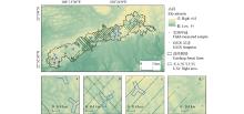
Fig.1
Geographical location of the study area and data distribution"
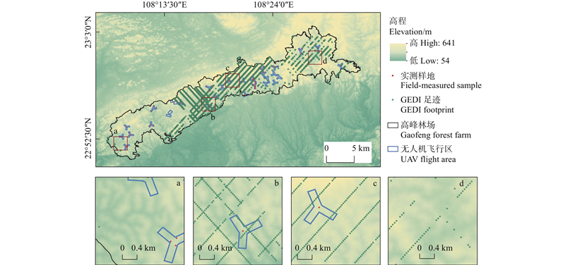
Table 1
Summary of field-measured plots information"
| 样地类别 Plots class | 样地数量 Plots number | 平均胸径 Mean DBH/cm | 平均树高 Average tree height/m | 林分密度 Stand density/ (tree?hm?2) | 异速生长方程 Allometric models | AGB(均值) AGB (mean)/ (Mg?hm?2) |
| 桉树Eucalyptus | 40 | 8.39~28.13 | 10.96~29.06 | 128~ | 34.82~213.30(94.57) | |
| 杉木Cunninghamia lanceolata | 9 | 14.97~26.93 | 11.98~20.16 | 208~ | 36.63~99.95(64.25) | |
| 红锥Castanopsis hystrix | 8 | 15.03~23.00 | 10.47~21.13 | 528~ | 79.90~259.52(180.13) |
Table 2
List of variables extracted from UAV-LiDAR point clouds"
| 类别 Class | 变量 Variable | 描述 Description | 类别 Class | 变量 Variable | 描述 Description | |
| 高度变量 Height variable | HX | 高度百分位 Height percentile | 强度变量 Intensity variable | IX | 强度百分位 Intensity percentile | |
| Hmean | 平均值 Mean | Imean | 平均值 Mean | |||
| Hmax | 最大值 Maximum (max) | Imax | 最大值 Maximum (max) | |||
| Hmin | 最小值 Minimum (min) | Imin | 最小值 Minimum (min) | |||
| Hmedian | 中位数 Median | Imedian | 中位数 Median | |||
| Hstd | 标准差 Standard deviation (std) | Istd | 标准差 Standard deviation (std) | |||
| Hcv | 变异系数 Coefficient of variation (cv) | Icv | 变异系数 Coefficient of variation (cv) | |||
| Hske | 偏斜度 Skewness (ske) | Iske | 偏斜度 Skewness (ske) | |||
| Hkur | 峰度 Kurtosis (kur) | Ikur | 峰度 Kurtosis (kur) | |||
| Hsqrt | 二次幂平均 Quadratic mean (sqrt) | Ivar | 方差 Variance (var) | |||
| Hcur | 三次幂平均 Cubic mean (cur) | — | — | |||
| Hvar | 方差 Variance (var) | — | — | |||
| 密度变量 Density variable | D0, …, D9 | 密度变量Density variable | 冠层特征Canopy feature | CC | 郁闭度 Canopy cover (CC) | |
| GF | 孔隙率 Gap fraction (GF) | |||||
| CRR | 冠层起伏度 Canopy relief ratio (CRR) |
Table 3
List of variables extracted from GEDI footprints"
| 产品 Product | 变量 Variable | 缩写 Abbreviation | 描述 Description |
| L2A | Rh | rh1, rh2, …, rh100 | 相对高度指标,以1%为间隔 Relative height metrics at 1% intervals (m) |
| L2B | Pai | pai | 植物面积指数 Plant area index |
| fhd_normal | fhd | 叶高多样性指数 Leaf-height diversity index | |
| Cover | cover | 总冠层覆盖度 Total canopy cover percentage | |
| modis_treecover | mt | MODIS数据的树木覆盖率 Tree cover fraction from MODIS | |
| modis_nonvegetated | mn | MODIS数据的非植被百分比 Non-Vegetated percentage in MODIS | |
| pgap_theta_aN | ptN | 森林冠层间隙概率 Forest canopy gap probability | |
| height_lastbin | hl | 相对森林冠层间隙误差的地面高度 Ground height relative to canopy gap error | |
| Rg | rgN | 选定波形中地面分量的积分 Integrated ground return energy (of selected waveform) | |
| Rv | rvN | 选定波形中植被分量的积分 Integrated vegetation return energy | |
| rx_energy_aN | reN | 去除平均噪声后接收到的波形总能量 Total waveform energy (noise-corrected) |
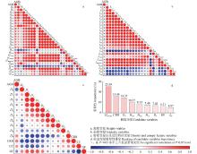
Fig.2
Correlation and importance of UAV-LiDAR point cloud feature variables and sample plot AGB"

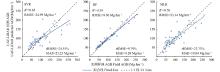
Fig.3
The scatter plots of UAV-LiDAR predicted AGB and field AGB"
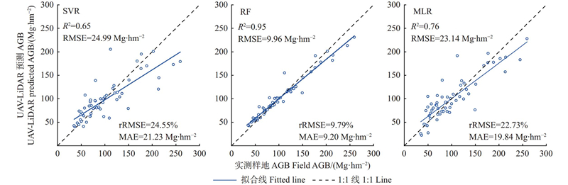
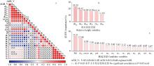
Fig.4
Correlation and Importance of GEDI feature variables with UAV-LiDAR regional AGB"
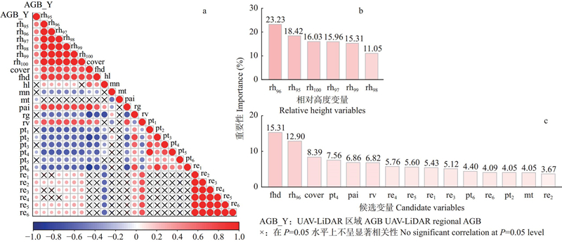
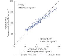
Fig.5
The scatter plot of UAV-LiDAR regional AGB and footprint AGB predicted by the RF model"
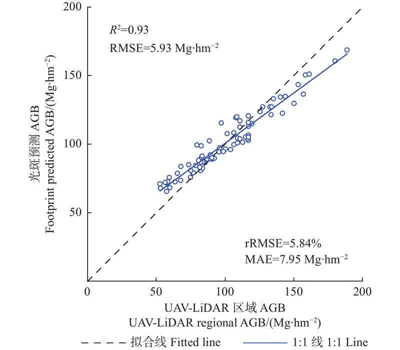
Fig.6
Comparison of forest AGB interpolation results in four local regions a1–a4 interpolation based on UAV-LiDAR regional AGB, b1–b4 interpolation based on GEDI footprint AGB, c1–c4 interpolation based on the combination of UAV-LiDAR regional AGB and GEDI footprint AGB. The four regions from left to right in each row correspond to those in Fig. 1."
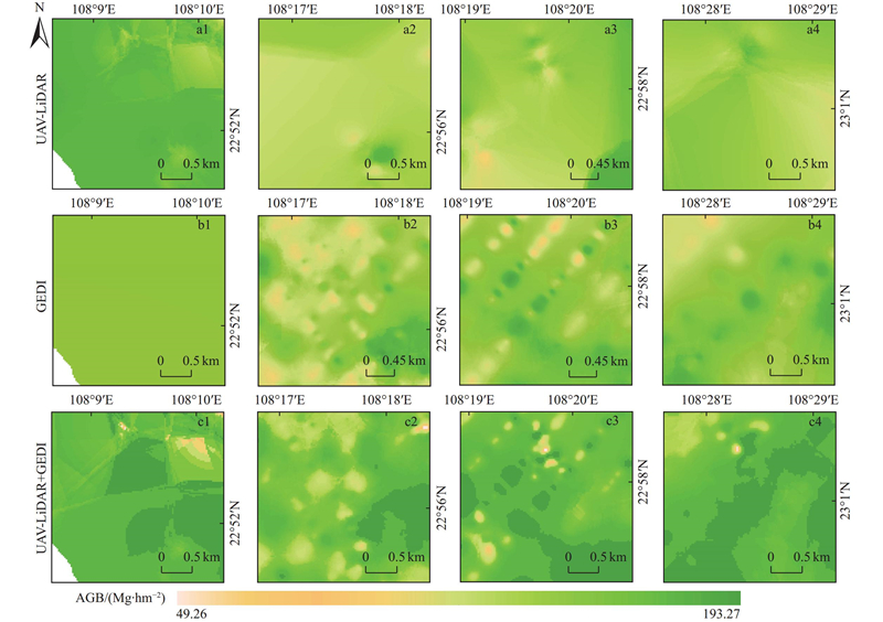
Fig.7
Spatial distribution of AGB in the study area"
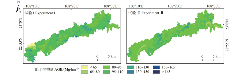
Table 4
Optimized features and evaluation metrics based on EBK interpolation"
| 特征Features | R2 | RMSE | MAE |
| fhd | 0.74 | 0.47 | 0.34 |
| rh96 | 0.80 | 8.00 | 6.38 |
| cover | 0.53 | 0.28 | 0.23 |
| pt4 | 0.59 | 0.28 | 0.24 |
| pai | 0.63 | 1.96 | 1.61 |
Table 5
Validation and Statistics of Estimation Results in the study area"
| 试验 Experiment | 样本类别 Sample class | 样本值Sample value/(Mg?hm?2) | 估算值Estimation results/(Mg?hm?2) | AGB均值 Mean AGB/(Mg?hm?2) | 精度评价Accuracy assessment | ||
| R2 | RMSE/(Mg?hm?2) | MAE/(Mg?hm?2) | |||||
| I | a | 47.17~213.25 | 51.03~174.69 | 101.33 | 0.62 | 27.66 | 21.91 |
| b | 65.42~168.66 | 77.99~130.94 | 98.43 | 0.69 | 15.55 | 10.25 | |
| c | 47.17~213.25 | 49.26~193.27 | 101.03 | 0.78 | 22.30 | 16.99 | |
| Ⅱ | d | 52.71~188.87 | 71.08~161.34 | 91.91 | 0.73 | 15.53 | 13.26 |
| 蔡会德, 卢 峰, 徐占勇, 等. 桉树相容性可加性立木生物量模型系统研建. 林业资源管理, 2023, (1): 87- 93. | |
| Cai H D, Lu F, Xu Z Y, et al. Research and development of compatible and additive individual tree biomass model systems for Eucalyptus. Forest and Grassland Resources Research, 2023, (1): 87- 93. | |
| 蔡会德, 农胜奇, 张 伟, 等. 广西主要树种立木生物量模型的研建. 林业资源管理, 2014, (4): 58- 61. | |
| Cai H D, Nong S Q, Zhang W, et al. Modeling of standing tree biomass for main species of trees in Guangxi Province. Forest and Grassland Resources Research, 2014, (4): 58- 61. | |
| 陈星京, 冯林艳, 张宇超, 等. 基于机载激光雷达的崇礼冬奥核心区林分地上生物量反演. 林业科学, 2022, 58 (10): 35- 46. | |
| Chen X J, Feng L Y, Zhang Y C, et al. Inversion of aboveground biomass in the core area of Chongli winter olympics based on airborne LiDAR. Scientia Silvae Sinicae, 2022, 58 (10): 35- 46. | |
| 高浩然, 周 勇, 刘甲康, 等. 基于EBK插值预测和GDM模型的襄州区耕地土壤重金属时空分布及来源变化分析. 环境科学, 2022, 43 (11): 5180- 5191. | |
| Gao H Y, Zhou Y, Liu J K, et al. Spatial and temporal distribution and source variation of heavy metals in cultivated land soil of Xiangzhou district based on EBK interpolation prediction and GDM model. Environmental Science, 2022, 43 (11): 5180- 5191. | |
| 李德仁, 王长委, 胡月明, 等. 遥感技术估算森林生物量的研究进展. 武汉大学学报(信息科学版), 2012, 37 (6): 631- 635. | |
| Li D R, Wang C W, Hu Y M, et al. General review on remote sensing-based biomass estimation. Geomatics and Information Science of Wuhan University, 2012, 37 (6): 631- 635. | |
|
李 兰, 陈尔学, 李增元, 等. 森林地上生物量的多基线InSAR层析估测方法. 林业科学, 2017, 53 (11): 85- 93.
doi: 10.11707/j.1001-7488.20171110 |
|
|
Li L, Chen E X, Li Z Y, et al. Forest above-ground biomass estimation based on multi-baseline InSAR tomography. Scientia Silvae Sinicae, 2017, 53 (11): 85- 93.
doi: 10.11707/j.1001-7488.20171110 |
|
| 刘立斌, 周运超, 程安云, 等. 利用皆伐法估算黔中喀斯特森林地上生物量. 生态学报, 2020, 40 (13): 4455- 4461. | |
| Liu L B, Zhou Y C, Cheng A Y, et al. Aboveground biomass estimate of a karst forest in central Guizhou Province, southwestern China based on direct harvest method. Acta Ecologica Sinica, 2020, 40 (13): 4455- 4461. | |
|
刘 茜, 杨 乐, 柳钦火, 等. 森林地上生物量遥感反演方法综述. 遥感学报, 2015, 19 (1): 62- 74.
doi: 10.11834/jrs.20154108 |
|
|
Liu Q, Yang L, Liu Q H, et al. Review of forest above ground biomass inversion methods based on remote sensing technology. Journal of Remote Sensing, 2015, 19 (1): 62- 74.
doi: 10.11834/jrs.20154108 |
|
|
刘世荣, 王 晖, 李海奎, 等. 碳中和目标下中国森林碳储量、碳汇变化预估与潜力提升途径. 林业科学, 2024, 60 (4): 157- 172.
doi: 10.11707/j.1001-7488.LYKX20230206 |
|
|
Liu S R, Wang H, Li H K, et al. Projections of China's forest carbon storage and sequestration and ways of their potential capacity enhancement. Scientia Silvae Sinicae, 2024, 60 (4): 157- 172.
doi: 10.11707/j.1001-7488.LYKX20230206 |
|
|
吕梓晴, 段爱国. 不同产区杉木生物量与碳储量模型. 林业科学, 2024, 60 (2): 1- 11.
doi: 10.11707/j.1001-7488.LYKX20220526 |
|
|
Lü Z Q, Duan A G. Biomass and carbon storage model of Cunninghamia lanceolata in different production areas. Scientia Silvae Sinicae, 2024, 60 (2): 1- 11.
doi: 10.11707/j.1001-7488.LYKX20220526 |
|
|
马泉来, 万小强, 杨崇科, 等. 南太行典型区小流域土壤铅含量空间分异及影响因素分析. 农业工程学报, 2023, 39 (18): 226- 233.
doi: 10.11975/j.issn.1002-6819.202306206 |
|
|
Ma Q L, Wan X Q, Yang C K, et al. Spatial differentiation and influencing factors analysis of Pb in soils in the small watershed of typical area in the Southern Taihang Mountains. Transactions of the Chinese Society of Agricultural Engineering, 2023, 39 (18): 226- 233.
doi: 10.11975/j.issn.1002-6819.202306206 |
|
| 孟 鸽, 赵 旦, 许 聪, 等. 联合ICESat-2和GEDI星载激光雷达数据的森林地上生物量估算. 遥感学报, 2024, 28 (6): 1632- 1647. | |
| Meng G, Zhao D, Xu C, et al. Forest aboveground biomass estimation combining ICESat-2 and GEDI spaceborne LiDAR data. National Remote Sensing Bulletin, 2024, 28 (6): 1632- 1647. | |
|
覃 林, 何友均, 李智勇, 等. 南亚热带红椎马尾松纯林及其混交林生物量和生产力分配格局. 林业科学, 2011, 47 (12): 17- 21.
doi: 10.11707/j.1001-7488.20111203 |
|
|
Tan L, He Y J, Li Z Y, et al. Allocation pattern of biomass and productivity for three plantations of Castanopsis hystrix, Pinus massoniana and their mixture in south subtropical area of Guangxi, China. Scientia Silvae Sinicae, 2011, 47 (12): 17- 21.
doi: 10.11707/j.1001-7488.20111203 |
|
| 王崇阳, 田 昕. 基于GF-1 PMS数据的森林覆盖变化检测. 遥感技术与应用, 2021, 36 (1): 208- 216. | |
| Wang C Y, Tian X. Forest cover change detection based on GF-1 PMS data. Remote Sensing Technology and Application, 2021, 36 (1): 208- 216. | |
| 赵厚本, 周光益, 李兆佳, 等. 南亚热带常绿阔叶林4个常见树种的生物量分配特征与异速生长模型. 林业科学, 2022, 58 (2): 23- 31. | |
| Zhao H B, Zhou G Y, Li Z J, et al. Biomass allocation and allometric growth models of four common tree species in southern subtropical evergreen broad-leaved forest. Scientia Silvae Sinicae, 2022, 58 (2): 23- 31. | |
| 周文武, 舒清态, 胥 丽, 等. 滇西北森林郁闭度估测模型——基于全球生态系统动力学调查多波束激光雷达数据. 生态学报, 2024, 44 (8): 3525- 3539. | |
| Zhou W W, Shu Q T, Xu L, et al. Construction of forest canopy closure estimation model in the northwestern Yunnan based on global ecosystem dynamics investigation multi-beam LiDAR data. Acta Ecologica Sinica, 2024, 44 (8): 3525- 3539. | |
| 朱 媛, 王亚鑫, 覃方锉, 等. 不同林龄桉树根际及非根际土壤微生物群落结构及功能研究. 生态学报, 2024, 44 (18): 8409- 8422. | |
| Zhu Y, Wang Y X, Tan F C, et al. Composition and function of soil microbial community in rhizosphere soil and bulk soil of Eucalyptus plantation across different stand ages. Acta Ecologica Sinic, 2024, 44 (18): 8409- 8422. | |
|
Bouvier M, Durrieu S, Fournier R A, et al. Generalizing predictive models of forest inventory attributes using an area-based approach with airborne LiDAR data. Remote Sensing of Environment, 2015, 156, 322- 334.
doi: 10.1016/j.rse.2014.10.004 |
|
|
Campbell M J, Eastburn J F, Dennison P E, et al. Evaluating the performance of airborne and spaceborne lidar for mapping biomass in the United States’ largest dry woodland ecosystem. Remote Sensing of Environment, 2024, 308, 114196.
doi: 10.1016/j.rse.2024.114196 |
|
|
Chen L, Ren C Y, Zhang B, et al. Improved estimation of forest stand volume by the integration of GEDI LiDAR data and multi-sensor imagery in the Changbai Mountains mixed forests ecoregion (CMMFE), northeast China. International Journal of Applied Earth Observations and Geoinformation, 2021, 100, 102326.
doi: 10.1016/j.jag.2021.102326 |
|
|
Chen Y S, Zhang S H, Wang Y D. Spatial distribution patterns and drivers of above- and below- biomass in Chinese terrestrial ecosystems. The Science of the Total Environment, 2024, 944, 173922.
doi: 10.1016/j.scitotenv.2024.173922 |
|
|
Crockett E T. H., Atkins J W., Guo Q F, et al. Structural and species diversity explain aboveground carbon storage in forests across the United States: Evidence from GEDI and forest inventory data. Remote Sensing of Environment, 2023, 295, 113703.
doi: 10.1016/j.rse.2023.113703 |
|
|
Dorado-Roda I, Pascual A, Godinho S, et al. Assessing the accuracy of GEDI data for canopy height and aboveground biomass estimates in Mediterranean forests. Remote Sensing, 2021, 13 (12): 2279.
doi: 10.3390/rs13122279 |
|
|
Dubayah R, Armston J, Healey S P, et al. GEDI launches a new era of biomass inference from space. Environmental Research Letters, 2022, 17 (9): 095001.
doi: 10.1088/1748-9326/ac8694 |
|
|
Duncanson L, Kellner J R, Armston J, et al. Aboveground biomass density models for NASA’s Global Ecosystem Dynamics Investigation (GEDI) lidar mission. Remote Sensing of Environment, 2022, 270, 112845.
doi: 10.1016/j.rse.2021.112845 |
|
|
Duncanson L, Neuenschwander A, Hancock S, et al. Biomass estimation from simulated GEDI, ICESat-2 and NISAR across environmental gradients in Sonoma County, California. Remote Sensing of Environment, 2020, 242, 111779.
doi: 10.1016/j.rse.2020.111779 |
|
|
Liu K, Shen X, Cao L, et al. Estimating forest structural attributes using UAV-LiDAR data in Ginkgo plantations. ISPRS Journal of Photogrammetry and Remote Sensing, 2018, 146, 465- 482.
doi: 10.1016/j.isprsjprs.2018.11.001 |
|
|
Liu X Q, Su Y J, Hu T Y, et al. Neural network guided interpolation for mapping canopy height of China's forests by integrating GEDI and ICESat-2 data. Remote Sensing of Environment, 2022, 269, 112844.
doi: 10.1016/j.rse.2021.112844 |
|
|
Lu D S, Chen Q, Wang G X, et al. A survey of remote sensing-based aboveground biomass estimation methods in forest ecosystems. International Journal of Digital Earth, 2016, 9 (1): 63- 105.
doi: 10.1080/17538947.2014.990526 |
|
|
Lucas R M, Mitchell A L, Armston J. Measurement of forest above-ground biomass using active and passive remote sensing at large (subnational to global) scales. Current Forestry Reports, 2015, 1 (3): 162- 177.
doi: 10.1007/s40725-015-0021-9 |
|
|
Luo H B, Qin S T, Li J, et al. High-density forest AGB estimation in tropical forest integrated with PolInSAR multidimensional features and optimized machine learning algorithms. Ecological Indicators, 2024, 160, 111878.
doi: 10.1016/j.ecolind.2024.111878 |
|
|
Ni-Meister W, Rojas A, Lee S. Direct use of large-footprint lidar waveforms to estimate aboveground biomass. Remote Sensing of Environment, 2022, 280, 113147.
doi: 10.1016/j.rse.2022.113147 |
|
| Padalia H, Prakash A, Watham T. Modelling aboveground biomass of a multistage managed forest through Synergistic Use of Landsat-OLI, ALOS-2 L-band SAR and GEDI metrics. Ecological Informatics, 2023, 77, 102234. | |
|
Pascual A, Neira G A, Santana M E, et al. Old-growth mapping in Patagonia’s evergreen forests must integrate GEDI data to overcome NFI data limitations and to effectively support biodiversity conservation. Forest Ecology and Management, 2024, 568, 122059.
doi: 10.1016/j.foreco.2024.122059 |
|
|
Potapov P, Li X Y, Hernandez-Serna A, et al. Mapping global forest canopy height through integration of GEDI and Landsat data. Remote Sensing of Environment, 2021, 253, 112165.
doi: 10.1016/j.rse.2020.112165 |
|
|
Qi W L, Lee S, Hancock S, et al. Improved forest height estimation by fusion of simulated GEDI LiDAR data and TanDEM-X InSAR data. Remote Sensing of Environment, 2019, 221, 621- 634.
doi: 10.1016/j.rse.2018.11.035 |
|
| Sheridan R D, Popescu S C, Gatziolis D, et al. Modeling forest aboveground biomass and volume using airborne LiDAR metrics and forest inventory and analysis data in the Pacific Northwest. Remote Sensing, 2015, 7 (1): 229- 255. | |
|
Silva C A, Duncanson L, Hancock S, et al. Fusing simulated GEDI, ICESat-2 and NISAR data for regional aboveground biomass mapping. Remote Sensing of Environment, 2021, 253, 112234.
doi: 10.1016/j.rse.2020.112234 |
|
|
Sun B, Rong R, Cui H, et al. How can integrated Space–Air–Ground observation contribute in aboveground biomass of shrub plants estimation in shrub-encroached grasslands?. International Journal of Applied Earth Observation and Geoinformation, 2024, 130, 103856.
doi: 10.1016/j.jag.2024.103856 |
|
|
Wang D Z, Wan B, Liu J, et al. Estimating aboveground biomass of the mangrove forests on northeast Hainan Island in China using an upscaling method from field plots, UAV-LiDAR data and Sentinel-2 imagery. International Journal of Applied Earth Observation and Geoinformation, 2020, 85, 101986.
doi: 10.1016/j.jag.2019.101986 |
|
|
Wang X Y, Liu C X, Lv G T, et al. Integrating multi-source remote sensing to assess forest aboveground biomass in the Khingan mountains of north-eastern China using machine-learning algorithms. Remote Sensing, 2022, 14 (4): 1039.
doi: 10.3390/rs14041039 |
|
| Yang Q L, Niu C Y, Liu X Q, et al. Mapping high-resolution forest aboveground biomass of China using multisource remote sensing data. GIScience and Remote Sensing, 2023, 60 (1): 2203303. | |
|
Zeng N, Jiang K J, Han P F, et al. The Chinese carbon-neutral goal: challenges and prospects. Advances in Atmospheric Sciences, 2022, 39 (8): 1229- 1238.
doi: 10.1007/s00376-021-1313-6 |
|
|
Zhao K G, Suarez J C, Garcia M, et al. Utility of multitemporal lidar for forest and carbon monitoring: tree growth, biomass dynamics, and carbon flux. Remote Sensing of Environment, 2018, 204, 883- 897.
doi: 10.1016/j.rse.2017.09.007 |
|
|
Zhu X X, Nie S, Wang C, et al. Consistency analysis of forest height retrievals between GEDI and ICESat-2. Remote Sensing of Environment, 2022, 281, 113244.
doi: 10.1016/j.rse.2022.113244 |
| [1] | Shihao Zhu,Zhiwei Wu,Zhengjie Li,Shun Li. Moisture Dynamics and Modeling of Ground Surface Fine Dead Combustibles in Pinus massoniana Forest in Southern Jiangxi, China [J]. Scientia Silvae Sinicae, 2024, 60(5): 158-168. |
| [2] | Shoujia Liu,Tuo He,Yang Lu,Lichao Jiao,Juan Guo,Wiedenhoeft Alex C,Yafang Yin. Quantitative Anatomy Analysis on Wood Feature Variability and Wood Identification of Swietenia Species [J]. Scientia Silvae Sinicae, 2024, 60(5): 169-176. |
| [3] | Huiling Tian,Jianhua Zhu,Xiao He,Xinyun Chen,Zunji Jian,Chenyu Li,Xueyuan Guo,Guosheng Huang,Wenfa Xiao. Projected Biomass Carbon Stock of Arbor Forest of Three Provinces in Northeastern China Based on Random Forest Model [J]. Scientia Silvae Sinicae, 2022, 58(4): 40-50. |
| [4] | Xinyuan Liu,Guang Yang,Jibin Ning,Daotong Geng,Hongzhou Yu,Xueying Di. Quality and Influencing Factors of Particulate Matter Released by Surface Fuel Combustion in Korean Pine Plantation [J]. Scientia Silvae Sinicae, 2022, 58(3): 97-106. |
| [5] | Xingjing Chen,Linyan Feng,Yuchao Zhang,Qingwang Liu,Zhaohui Yang,Liyong Fu,Jinhua Bai. Inversion of Aboveground Biomass in the Core Area of Chongli Winter Olympics Based on Airborne LiDAR [J]. Scientia Silvae Sinicae, 2022, 58(10): 35-46. |
| [6] | Xuzhan Guo,Qiao Chen,Xiaofang Zhang,Liang Hong,Yuanyuan You,Shouzheng Tang,Liyong Fu. Extraction of Healthy Canopy of New Afforestation for Pinus tabulaeformis Based on UAV High-Resolution Image [J]. Scientia Silvae Sinicae, 2022, 58(10): 111-120. |
| [7] | Zhongqiu Sun,Jinping Gao,Fayun Wu,Xianlian Gao,Yang Hu,Jianxin Gao. Estimating Forest Stock Volume via Small-Footprint LiDAR Point Cloud Data and Random Forest Algorithm [J]. Scientia Silvae Sinicae, 2021, 57(8): 68-81. |
| [8] | Jiaqi You,Mingze Li,Wenyi Fan,Ying Quan,Bin Wang,Zhukun Mo,Zixiao Zhu. Stand Type Identification Based on Hyperspectral and LiDAR Data [J]. Scientia Silvae Sinicae, 2021, 57(5): 119-129. |
| [9] | Ying Pan,Mingming Ding,Jie Lin,Qiao Dai,Geng Guo,Linlin Cui. Inversion of Forest Leaf Area Index Based on PROSAIL Model and Multi-Angle Remote Sensing Data [J]. Scientia Silvae Sinicae, 2021, 57(4): 90-106. |
| [10] | Wenbo Li,Zhengang Lü,Xuanrui Huang,Zhidong Zhang. Predicting Spatial Distribution of Site Index for Larix principis-rupprechtii Plantations in the Northern Hebei Province [J]. Scientia Silvae Sinicae, 2021, 57(3): 79-89. |
| [11] | Jiaqi Ding,Wenli Huang,Yingchun Liu,Yang Hu. Estimation of Forest Aboveground Biomass in Northwest Hunan Province Based on Machine Learning and Multi-Source Data [J]. Scientia Silvae Sinicae, 2021, 57(10): 36-48. |
| [12] | Lei Zhang, Pengsen Sun, Shirong Liu. Growing-Season Transpiration of Typical Forests in Different Succession Stages in Subalpine Region of Western Sichuan, China [J]. Scientia Silvae Sinicae, 2020, 56(1): 1-9. |
| [13] | Hou Xiaojing, Ming Jinke, Qin Rongshui, Zhu Jiping. Analysis of the Fire Risk in Wildland-Urban Interface with Random Forest Model [J]. Scientia Silvae Sinicae, 2019, 55(8): 194-200. |
| [14] | Jie Lan,Xiangdong Lei,Yutao Zhang. Analysis on Trade-Offs and Synergies of Multiple Functions of Picea schrenkiana Forests in Central Tianshan Mountains [J]. Scientia Silvae Sinicae, 2019, 55(11): 9-18. |
| [15] | Yingkai Zhang,Pengju Liu,Changchun Liu,Yi Ren. Prediction Method of Cunninghamia lanceolata Growth Based on Spatial Clustering [J]. Scientia Silvae Sinicae, 2019, 55(11): 137-144. |
| Viewed | ||||||
|
Full text |
|
|||||
|
Abstract |
|
|||||