
Scientia Silvae Sinicae ›› 2021, Vol. 57 ›› Issue (4): 90-106.doi: 10.11707/j.1001-7488.20210410
Previous Articles Next Articles
Ying Pan1,2,Mingming Ding3,Jie Lin1,*,Qiao Dai1,Geng Guo1,Linlin Cui1
Received:2019-06-18
Online:2021-04-25
Published:2021-05-21
Contact:
Jie Lin
CLC Number:
Ying Pan,Mingming Ding,Jie Lin,Qiao Dai,Geng Guo,Linlin Cui. Inversion of Forest Leaf Area Index Based on PROSAIL Model and Multi-Angle Remote Sensing Data[J]. Scientia Silvae Sinicae, 2021, 57(4): 90-106.
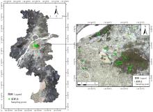
Fig.1
Distribution of sampling points"

Table 1
Descriptive statistics of LAI values of different vegetation types in sampling points"
| 植被类型 Vegetation types | 样点数 Sample number | 最小值 Min. | 最大值 Max. | 平均值 Mean | 偏度 Skewness | 峰度 Kurtosis | 变异系数 Coefficient of variation (%) |
| 阔叶林 Broadleaf forest | 59 | 1.70 | 6.30 | 3.90 | -0.08 | 0.77 | 24.36 |
| 针叶林 Coniferous forest | 18 | 2.28 | 4.61 | 3.62 | -0.38 | -0.74 | 20.58 |
| 针阔混交林 Coniferous-broadleaf forest | 37 | 2.82 | 6.70 | 4.06 | 0.85 | 0.92 | 22.48 |
| 全样本 Full sample | 114 | 1.70 | 6.70 | 3.91 | 0.23 | 0.84 | 23.36 |
Table 2
Multi-angle remote sensing data resources"
| 数据类型 Data type | 成像时间 Imaging time | 波谱范围 Band range | 分辨率 Resolution ratio |
| PROBA/CHRIS | 2015-09-07 | 0.4~1.1 | 17 |
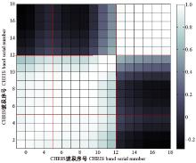
Fig.2
Correlation coefficient matrix between CHRIS image bands"
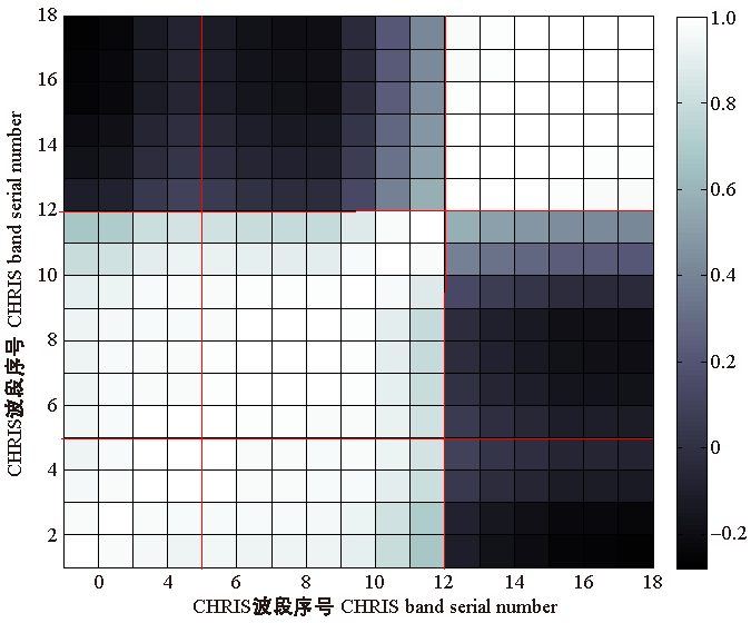
Table 3
Parameter settings of sensitivity analysis"
| 参数设置 Parameter setting | 分析参数 Analysis parameters | |||||
| LAI | N | Cab | Cw | Cm | SL | |
| LAI | 1-0.5-7 | 3.8 | 3.8 | 3.8 | 3.8 | 3.8 |
| N | 1.50 | 1-0.1-2.5 | 1.50 | 1.50 | 1.50 | 1.50 |
| Cab | 44.72 | 44.72 | 20-5-70 | 44.72 | 44.72 | 44.72 |
| Cw | 0.015 3 | 0.015 3 | 0.015 3 | 0.006-0.02-0.06 | 0.015 3 | 0.015 3 |
| Cm | 0.008 3 | 0.008 3 | 0.008 3 | 0.008 3 | 0.004-0.002-0.04 | 0.008 3 |
| SL | 0.15 | 0.15 | 0.15 | 0.15 | 0.15 | 0.01-0.05-0.31 |
| θs | 61.88 | 61.88 | 61.88 | 61.88 | 61.88 | 61.88 |
| θv | 20.18 | 20.18 | 20.18 | 20.18 | 20.18 | 20.18 |
| φ | 214.36 | 214.36 | 214.36 | 214.36 | 214.36 | 214.36 |
Table 4
Vegetation indices and their expressions"
| 植被指数 Vegetation indices | 表达式 Expressions | 参考文献 References |
| 比值植被指数 Ratio vegetation index(RVI) | ρNIR/ρRED | |
| 归一化植被指数Normalized difference vegetation index(NDVI) | (ρNIR-ρRED)/(ρNIR+ρRED) | |
| 垂直植被指数 Perpendicular vegetation index(PVI) | ||
| 差值植被指数 Difference vegetation index(DVI) | ρNIR-ρRED | |
| 土壤调节植被指数 Soil adjusted vegetation index(SAVI) | 1.5(ρNIR-ρRED)/(ρNIR+ρRED+0.5) | |
| 增强型植被指数 Enhanced vegetation index(EVI) | 2.5(ρNIR-ρRED)/(ρNIR+6.0ρRED-7.5ρBLUE+1) | |
| 修正土壤调节植被指数 Modified soil adjusted vegetation index(MSAVI) | ||
| 结构不敏感色素(植被)指数 Structure insensitive pigment (vegetation) index(SIPI) | (ρNIR-ρBLUE)/(ρNIR+ρBLUE) |

Fig.3
Pretreatment flow chart of LAI inversion"
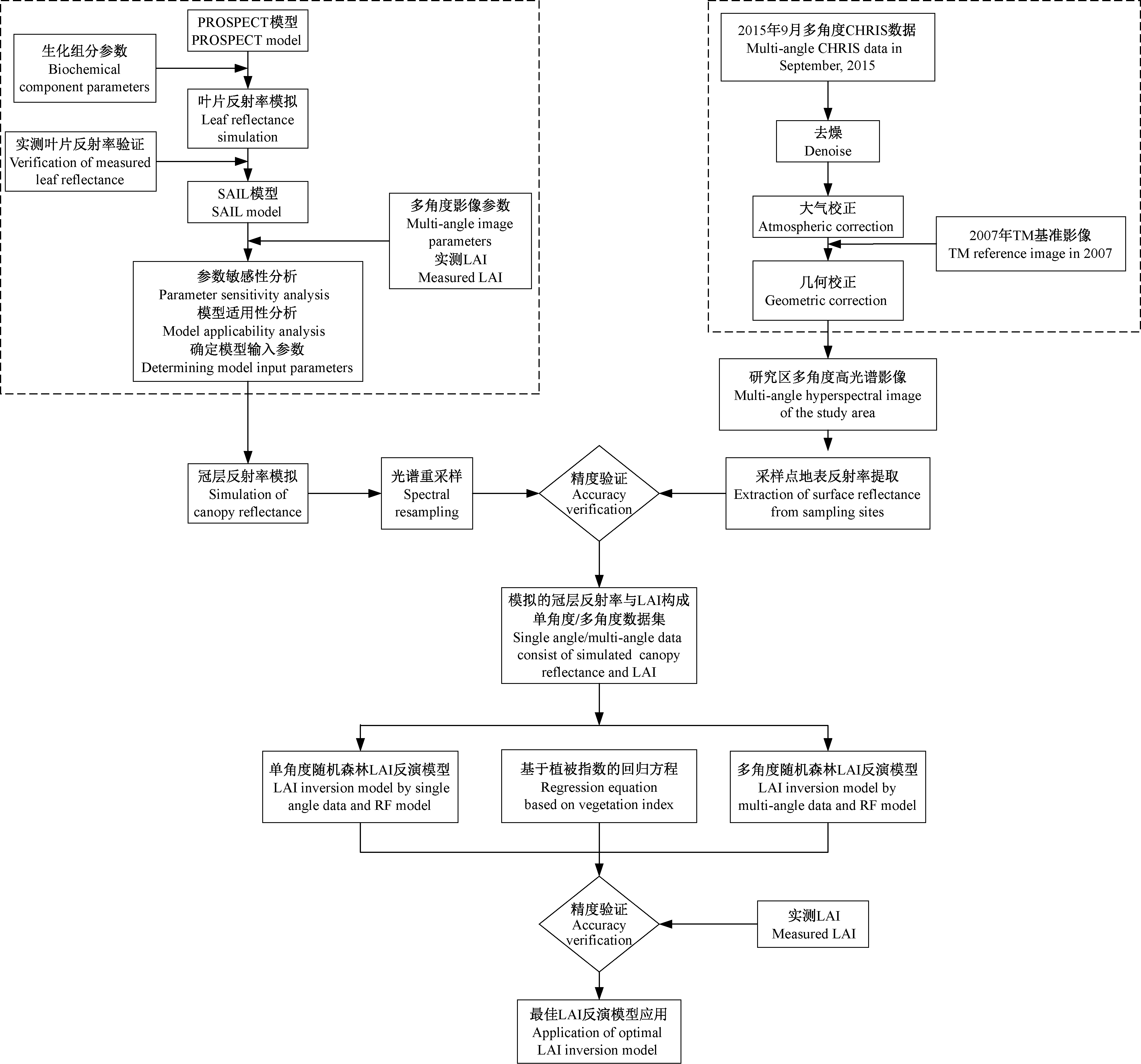
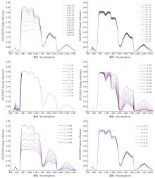
Fig.4
Curve of canopy reflectance with different model parameters"

Table 5
Sensitivity calculation results of each parameter in the PROSAIL model"
| 等级 Level | LAI | N | Cab | Cm | Cw | SL |
| 1 | 0.332 86 | 0.021 60 | 0.261 82 | 0.068 09 | 0.011 88 | 0.023 62 |
| 2 | 0.227 62 | 0.026 81 | 0.085 11 | 0.058 56 | 0.011 42 | 0.021 18 |
| 3 | 0.161 23 | 0.039 96 | 0.034 61 | 0.051 89 | 0.011 00 | 0.017 98 |
| 4 | 0.121 63 | 0.047 22 | 0.023 76 | 0.046 93 | 0.010 61 | 0.015 47 |
| 5 | 0.096 81 | 0.050 54 | 0.016 87 | 0.043 08 | 0.010 26 | 0.013 49 |
| 平均值 Mean | 0.188 03 | 0.037 23 | 0.084 43 | 0.053 71 | 0.011 03 | 0.018 35 |
Table 6
Variable input parameters and ranges of PROSAIL model"
| 变化参数 Variable parameters | 参数描述 Parametric description | 参数值 Parameter values | ||
| 最小值 Min. | 最大值 Max. | 步长 Step | ||
| LAI | 叶面积指数 Leaf area index | 0.5 | 6.5 | 0.02 |
| Cab/(μg·cm-2) | 叶片叶绿素a、b含量 Chlorophyll a and b content | 20 | 70 | 5 |
| θv/(°) | 观测天顶角 Observation zenith angle | 20.18,39.47,37.27,57.65,56.04 | ||
| φ | 太阳-卫星相对方位角 Sun-satellite relative azimuth angle | 214.36,111.77,243.56,103.82,246.91 | ||
Table 7
Constant input parameters of PROSAIL model"
| 常量参数 Constant parameters | 参数描述 Parametric description | 参数值 Parameter values |
| Cw/cm | 叶片等效水厚度 Leaf equivalent water thickness | 0.015 3 |
| Cm/(g·cm-2) | 叶片干物质含量 Leaf dry matter content | 0.008 3 |
| N | 叶片结构参数 Leaf structure parameter | 1.5 |
| θs | 太阳天顶角 Sun zenith angle | 61.88 |
| SL | 热点效应参数 Hot spot effect parameter | 0.15 |
| ALA | 平均叶倾角 Average leaf inclination angle | Spherical |
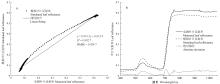
Fig.5
The relationship between the simulated and measured leaf reflectance"

Table 8
Accuracies of simulated canopy reflectance and image reflectance at different angles"
| 指标 Index | -55° | -36° | 0° | 36° | 55° |
| RMSE | 0.127 2 | 0.065 2 | 0.047 3 | 0.054 7 | 0.091 3 |
| MAPE | 0.654 7 | 0.412 5 | 0.376 1 | 0.393 7 | 0.421 7 |
Table 9
Correlation analysis results of LAI and vegetation indices at different angles"
| 植被指数 Vegetation indices | -55° | -36° | 0° | 36° | 55° |
| RVI | 0.191 7 | 0.300 3* | 0.362 2** | 0.287 5** | 0.179 6** |
| NDVI | 0.162 7 | 0.265 5* | 0.327 4** | 0.253 3** | 0.149 9 |
| PVI | 0.903 5** | 0.900 4** | 0.907 6** | 0.900 0** | 0.892 1** |
| DVI | 0.871 1** | 0.883 8** | 0.894 0** | 0.882 6** | 0.862 5** |
| SAVI | 0.760 1** | 0.827 1** | 0.848 8** | 0.821 9** | 0.753 3** |
| EVI | 0.809 6** | 0.852 3** | 0.867 9** | 0.848 9** | 0.803 3** |
| MSAVI | 0.735 5** | 0.832 5** | 0.859 2** | 0.824 7** | 0.721 9** |
| SIPI | 0.567 6** | 0.708 6** | 0.748 7** | 0.699 5** | 0.558 0** |
Table 10
Observation angle combinations of LAI inversion model"
| 角度数目 Angle number | 组合数 Combination number | 角度组合形式 Angle combination forms |
| 单角度 Single angle | 5 | 0°,36°,-36°,55°,-55° |
| 2角度 Two angles | 10 | (0°,36°),(0°,-36°),(0°,55°),(0°,-55°),(36°,-36°),(36°,55°),(36°,-55°),(-36°,55°),(-36°,-55°),(55°,-55°) |
| 3角度 Three angles | 10 | (0°,36°,-36°),(0°,36°,55°),(0°,36°,-55°),(0°,-36°,55°),(0°,-36°,-55°),(0°,55°,-55°),(36°,-36°,55°),(36°,-36°,-55°),(36°,55°,-55°),(-36°,55°,-55°) |
| 4角度 Four angles | 5 | (0°,36°,-36°,55°),(0°,36°,-36°,-55°),(0°,36°,55°,-55°),(0°,-36°,55°,-55°),(36°,-36°,55°,-55°) |
| 5角度 Five angles | 1 | (0°,36°,-36°,55°,-55°) |
Table 11
Accuracies of random forest LAI inversion model based on single angle data"
| 观测角度 Observation angle | R2 | RMSE | MAPE |
| -55° | 0.908 3 | 0.245 8 | 0.046 1 |
| -36° | 0.641 1 | 0.486 2 | 0.060 1 |
| 0° | 0.908 9 | 0.244 9 | 0.044 9 |
| 36° | 0.909 9 | 0.243 6 | 0.043 7 |
| 55° | 0.915 7 | 0.235 7 | 0.042 6 |
Table 12
Accuracies of random forest LAI inversion model based on multi-angle data"
| 角度数目 Angle number | 观测角度组合 Observation angle combination | R2 | RMSE | MAPE |
| 2角度 Two angles | 0°,55° | 0.917 6 | 0.233 0 | 0.042 3 |
| 3角度 Three angles | 0°,36°,55° | 0.918 4 | 0.231 9 | 0.041 5 |
| 4角度 Four angles | 0°,36°,55°,-55° | 0.917 7 | 0.232 9 | 0.041 6 |
| 5角度 Five angles | 0°,36°,-36°,55°,-55° | 0.914 3 | 0.237 6 | 0.043 4 |
Table 13
Summary with the highest accuracies of non-linear regression models based on single and multi-angle data"
| 角度数目 Angle number | 观测角度/角度组合 Observation angle/angle combination | 模型 Models | R2 | RMSE | MAPE |
| 单角度 Single angle | 55° | y = 0.053 9exp(7.875 0PVI) | 0.909 3 | 0.278 6 | 0.048 4 |
| 2角度 Two angles | 0°,36° | y = 0.028 7exp(5.713 1PVI) | 0.910 6 | 0.267 8 | 0.047 4 |
| 3角度 Three angles | 0°,36°,55° | y = 0.045 2exp(8.297 7PVI) | 0.911 2 | 0.248 6 | 0.045 7 |
| 4角度 Four angles | 0°,36°,36°,-55° | y = 0.031 5exp(4.246 4PVI) | 0.904 8 | 0.280 4 | 0.049 0 |
| 5角度 Five angles | 0°,36°,-36°,55°,-55° | y = 0.027 1exp(3.376 0PVI) | 0.901 8 | 0.284 5 | 0.051 3 |
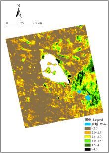
Fig.6
The LAI distribution obtained by using 0°, 36° and 55° based on the PROBA/CHRIS data"


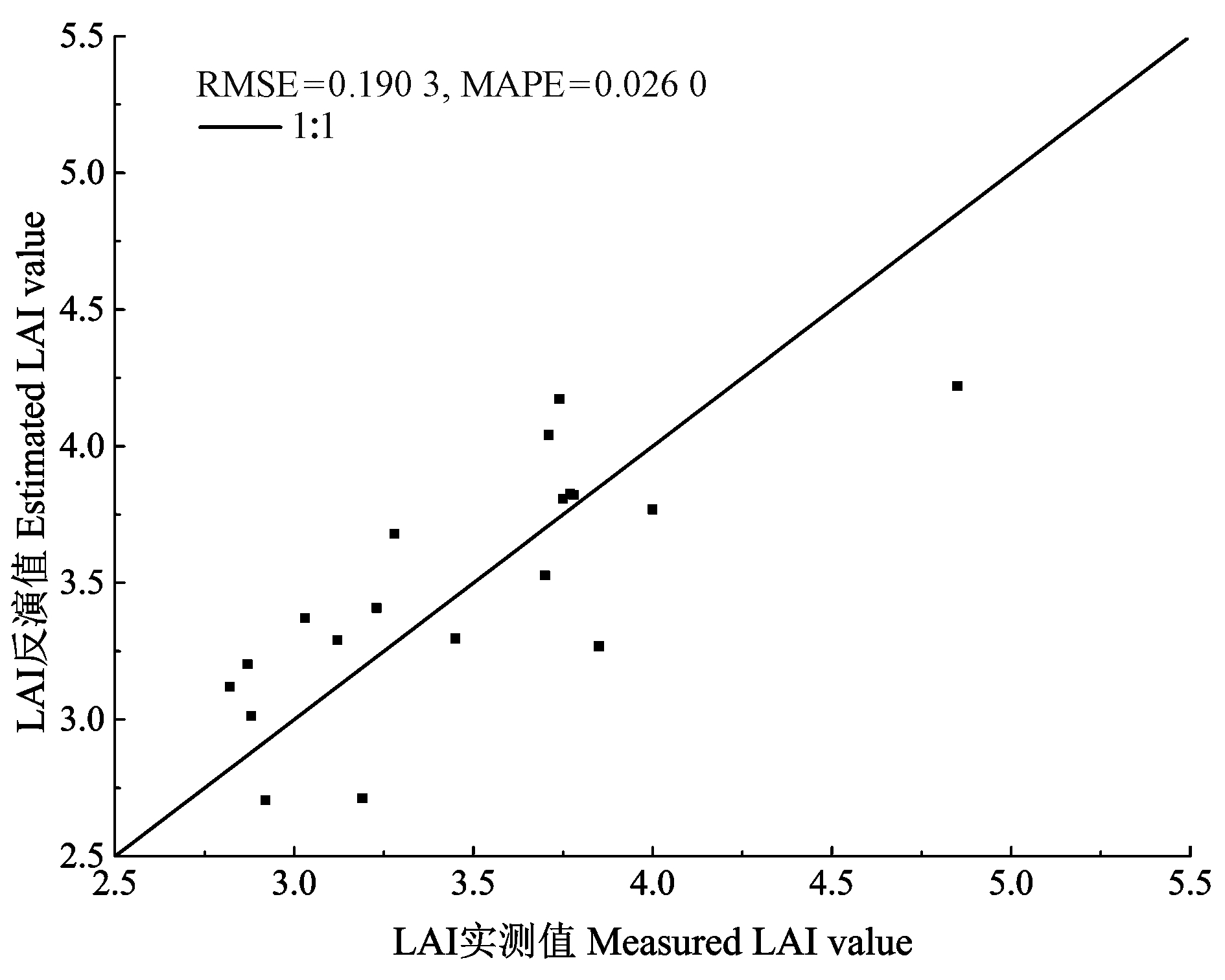
Fig.7
The scatter plot between the measured LAI and estimated LAI"
|
蔡博峰, 绍霞. 基于PROSPECT+SAIL模型的遥感叶面积指数反演. 国土资源遥感, 2007, 72 (2): 39- 43.
doi: 10.3969/j.issn.1001-070X.2007.02.010 |
|
|
Cai B F , Shao X . Remote sensing leaf area index inversion based on PROSPECT+SAIL model. Remote Sensing for Land and Resources, 2007, 72 (2): 39- 43.
doi: 10.3969/j.issn.1001-070X.2007.02.010 |
|
|
曹建军, 顾祝军, 徐建华, 等. 基于CHRIS/PROBA的植被叶面积指数估算模型研究. 安徽农业科学, 2013, 41 (2): 907- 910.
doi: 10.3969/j.issn.0517-6611.2013.02.156 |
|
|
Cao J J , Gu Z J , Xu J H , et al. Estimation models of leaf area index (LAI) based on remote sensing image of CHRIS/PROBA. Journal of Anhui Agriculture Science, 2013, 41 (2): 907- 910.
doi: 10.3969/j.issn.0517-6611.2013.02.156 |
|
| 陈添兴. 2012. 南京紫金山大型菌物多样性研究. 南京: 南京师范大学硕士学位论文. | |
| Chen T X. 2012. Study on the diversity of large bacteria in Mt. Zijin of Nanjing city. Nanjing: MS thesis of Nanjing Normal University. [in Chinese] | |
| 杜育璋, 姜小光, 张雨泽, 等. 基于Landsat-8遥感数据和PROSAIL辐射传输模型反演叶面积指数. 干旱区地理, 2016, 39 (5): 1096- 1103. | |
| Du Y Z , Jiang X G , Zhang Y Z , et al. Retrieving leaf area index using PROSAIL radiative transfer model based on Landsat-8 image. Arid Land Geography, 2016, 39 (5): 1096- 1103. | |
| 谷成燕, 杜华强, 周国模, 等. 基于PROSAIL辐射传输模型的毛竹林叶面积指数遥感反演. 应用生态学报, 2013, 24 (8): 2248- 2256. | |
| Gu C Y , Du H Q , Zhou G M , et al. Retrieval of leaf area index of moso bamboo forest with Landsat Thematic Mapper image based on PROSAIL canopy radiative transfer model. Chinese Journal of Applied Ecology, 2013, 24 (8): 2248- 2256. | |
| 韩兆迎, 朱西存, 房贤一, 等. 基于SVM与RF的苹果树冠LAI高光谱估测. 光谱学与光谱分析, 2016, 36 (3): 800- 805. | |
| Han Z Y , Zhu X C , Fang X Y , et al. Hyperspectral estimation of apple crown LAI based on SVM and RF. Spectroscopy and Spectral Analysis, 2016, 36 (3): 800- 805. | |
| 李粉玲, 王力, 刘京, 等. 基于高分一号卫星数据的冬小麦叶片SPAD值遥感估算. 农业机械学报, 2015, 46 (9): 273- 281. | |
| Li F L , Wang L , Liu J , et al. Remote sensing estimation of SPAD value for wheat leaf based on GF-1 data. Journal of Agricultural Machinery, 2015, 46 (9): 273- 281. | |
| 李林. 2004. 南京幕府山植物区系及其野生观赏植物资源应用研究. 南京: 南京林业大学硕士学位论文. | |
| Li L. 2004. Studies on flora of Mt. Mufu, Nanjing and the application of the wild ornamental plant resources. Nanjing: MS thesis of Nanjing Forestry University. [in Chinese] | |
| 李新辉, 宋小宁, 冷佩. 利用CHRIS/PROBA数据定量反演草地LAI方法研究. 国土资源遥感, 2011, 90 (3): 61- 66. | |
| Li X H , Song X N , Leng P . A quantitative method for grassland LAI inversion based on CHRIS/PROBA data. Remote Sensing for Land and Resources, 2011, 90 (3): 61- 66. | |
|
李映雪, 朱艳, 戴廷波, 等. 小麦叶面积指数与冠层反射光谱的定量关系. 应用生态学报, 2006, 17 (8): 1443- 1447.
doi: 10.3321/j.issn:1001-9332.2006.08.017 |
|
|
Li Y X , Zhu Y , Dai T B , et al. Quantitative relationship between leaf area index and canopy reflectance spectrum in wheat. Journal of Applied Ecology, 2006, 17 (8): 1443- 1447.
doi: 10.3321/j.issn:1001-9332.2006.08.017 |
|
|
林文鹏, 赵敏, 张翼飞, 等. 基于SPOT5遥感影像的城市森林叶面积指数反演. 测绘科学, 2008, 33 (2): 57- 59.
doi: 10.3771/j.issn.1009-2307.2008.02.020 |
|
|
Lin W P , Zhao M , Zhang Y F , et al. Study on estimation of urban forest LAI model based on SPOT5. Science of Surveying and Mapping, 2008, 33 (2): 57- 59.
doi: 10.3771/j.issn.1009-2307.2008.02.020 |
|
| 刘国华. 2004. 南京幕府山构树种群生态学及矿区废弃地植被恢复技术研究. 南京: 南京林业大学博士学位论文. | |
| Liu G H. 2004. Studies on flora of Mt. Mufu, Nanjing and the application of the wild ornamental plant resources. Nanjing: PhD thesis of Nanjing Forestry University. [in Chinese] | |
| 刘天凤. 2014. 基于PROSAIL模型的干旱半干旱地区LAI遥感反演建模. 兰州: 兰州大学硕士学位论文. | |
| Liu T F. 2014. Remote sensing modeling of leaf area index in arid and semi-arid region based on PROSAIL model. Lanzhou: MS thesis of Lanzhou University. [in Chinese] | |
| 柳艺博, 居为民, 陈镜明, 等. 2000~2010年中国森林叶面积指数时空变化特征. 科学通报, 2012, 57 (16): 1435- 1445. | |
| Liu Y B , Ju W M , Chen J M , et al. Temporal and spatial variation characteristics of forest leaf area index in China from 2000 to 2010. Science China Press, 2012, 57 (16): 1435- 1445. | |
| 吕杰. 2012. 基于机器学习和辐射传输模型的农作物叶绿素含量高光谱反演模型. 北京: 中国地质大学博士学位论文. | |
| Lü J. 2012. Hyperspectral remote sensing inversion model of crop chlorophyll content based on machine learning and radiative transfer models. Beijing: PhD thesis of China University of Geosciences. [in Chinese] | |
| 石锋. 2012. 基于HJ-1B星影像和PROSAIL模型相思树LAI反演. 福州: 福建师范大学硕士学位论文. | |
| Shi F. 2012. LAI inversion of A. richii based on HJ-1B satellite imagery data and PROSAIL model. Fuzhou: MS thesis of Fujian Normal University. [in Chinese] | |
|
宋开山, 张柏, 王宗明, 等. 基于人工神经网络的大豆叶面积高光谱反演研究. 中国农业科学, 2006, 39 (6): 1138- 1145.
doi: 10.3321/j.issn:0578-1752.2006.06.007 |
|
|
Song K S , Zhang B , Wang Z M , et al. Study on hyperspectral inversion of soybean leaf area based on artificial neural network. Chinese Agricultural Science, 2006, 39 (6): 1138- 1145.
doi: 10.3321/j.issn:0578-1752.2006.06.007 |
|
| 王春. 2009. 南京紫金山植物区系与植物资源研究. 南京: 南京林业大学硕士学位论文. | |
| Wang C. 2009. Studies on flora of Mt. Zijin vascular plants and studies of wild resource plants. Nanjing: MS thesis of Nanjing Forestry University. [in Chinese] | |
| 王李娟, 牛铮. PROSAIL模型的参数敏感性研究. 遥感技术与应用, 2014, 29 (2): 219- 223. | |
| Wang L J , Niu Z . Sensitivity analysis of vegetation parameters based on PROSAIL model. Remote Sensing Technology and Application, 2014, 29 (2): 219- 223. | |
| 吴伶, 刘湘南, 周博天, 等. 利用PROSPECT+SAIL模型反演植物生化参数的植被指数优化模拟. 应用生态学报, 2012, 23 (12): 3250- 3256. | |
| Wu L , Liu X N , Zhou B T , et al. Simulation of vegetation indices optimizing under retrieval of vegetation biochemical parameters based on PROSPECT + SAIL model. Chinese Journal of Applied Ecology, 2012, 23 (12): 3250- 3256. | |
| 吴志明, 李建超, 王睿, 等. 基于随机森林的内陆湖泊水体有色可溶性有机物(CDOM)浓度遥感估算. 湖泊科学, 2018, 30 (4): 979- 991. | |
| Wu Z M , Li J C , Wang R , et al. Estimation of CDOM concentration in inland lake based on random forest using Sentine-3A OLCI. Journal of Lake Sciences, 2018, 30 (4): 979- 991. | |
| 邢著荣. 2010. 基于辐射传输模型和CHRIS数据反演春小麦LAI. 青岛: 山东科技大学硕士学位论文. | |
| Xing Z R. 2010. Inversion of leaf area index of spring wheat based on radiative transfer model and CHRIS data. Qingdao: MS thesis of Shandong University of Science and Technology. [in Chinese] | |
| 杨福芹, 冯海宽, 李振海, 等. 基于赤池信息量准则的冬小麦叶面积指数高光谱估测. 农业工程学报, 2016, 32 (3): 163- 168. | |
| Yang F Q , Feng H K , Li Z H , et al. Hyperspectral estimation of leaf area index of winter wheat based on Chichi information criterion. Journal of Agricultural Engineering, 2016, 32 (3): 163- 168. | |
|
杨贵军, 赵春江, 邢著荣, 等. 基于PROBA/CHRIS遥感数据和PROSAIL模型的春小麦LAI反演. 农业工程学报, 2011, 27 (10): 88- 94.
doi: 10.3969/j.issn.1002-6819.2011.10.016 |
|
|
Yang G J , Zhao C J , Xing Z R , et al. LAI inversion of spring wheat based on PROBA/CHRIS hyperspectral multi-angular data and PROSAIL model. Transactions of the Chinese Society of Agricultural Engineering, 2011, 27 (10): 88- 94.
doi: 10.3969/j.issn.1002-6819.2011.10.016 |
|
|
杨慧乔, 冯仲科, 葛忠强, 等. 崂山林场森林冠层叶面积指数反演研究. 山东林业科技, 2014, 44 (2): 7- 10.
doi: 10.3969/j.issn.1002-2724.2014.02.002 |
|
|
Yang H Q , Feng Z K , Ge Z Q , et al. Study on leaf area index of Laoshan forest canopy. Shangdong Forestry Science and Technology, 2014, 44 (2): 7- 10.
doi: 10.3969/j.issn.1002-2724.2014.02.002 |
|
|
杨敏, 林杰, 顾哲衍, 等. 基于Landsat 8 OLI多光谱影像数据和BP神经网络的叶面积指数反演. 中国水土保持科学, 2015, 13 (4): 86- 93.
doi: 10.3969/j.issn.1672-3007.2015.04.013 |
|
|
Yang M , Lin J , Gu Z Y , et al. Leaf area index retrieval based on Landsat 8 OLI multi-spectral image data and BP neural network. Science of Soil and Water Conservation, 2015, 13 (4): 86- 93.
doi: 10.3969/j.issn.1672-3007.2015.04.013 |
|
|
杨勤科, 罗万勤, 马宏斌, 等. 区域水土流失植被因子的遥感提取. 水土保持研究, 2006, 13 (5): 267- 268.
doi: 10.3969/j.issn.1005-3409.2006.05.085 |
|
|
Yang Q K , Luo W Q , Ma H B , et al. NDVI extraction of regional soil erosion based on remote sensing. Research of Soil and Water Conservation, 2006, 13 (5): 267- 268.
doi: 10.3969/j.issn.1005-3409.2006.05.085 |
|
| 姚雄, 余坤勇, 杨玉洁, 等. 基于随机森林模型的林地叶面积指数遥感估算. 农业机械学报, 2017, 48 (5): 164- 171. | |
| Yao X , Yu K Y , Yang Y J , et al. Estimation of forest leaf area index based on random forest model and remote sensing data. Journal of Agricultural Machinery, 2017, 48 (5): 164- 171. | |
| 余金林. 2014. 基于PROSAIL模型的青海湖流域草地叶面积指数反演. 西宁: 青海师范大学硕士学位论文. | |
| Yu J L. 2014. Leaf area index inversion of grass in Qinghai Lake basin based PROSAIL model. Xining: MS thesis of Qinghai Normal University. [in Chinese] | |
|
张海波, 李峰. ASD地物光谱仪测量技术及使用方法. 山东气象, 2014, 34 (1): 46- 48.
doi: 10.3969/j.issn.1005-0582.2014.01.009 |
|
|
Zhang H B , Li F . Measurement technology and application method of ASD ground object spectrometer. Shandong Meteorology, 2014, 34 (1): 46- 48.
doi: 10.3969/j.issn.1005-0582.2014.01.009 |
|
| 张清林, 陈文惠, 张永贺, 等. 基于红边位置的台湾相思树叶片叶绿素含量估测模型研究. 亚热带资源与环境学报, 2011, 6 (3): 9- 17. | |
| Zhang Q L , Chen W H , Zhang Y H , et al. Estimation models of chlorophyll contents in leaves of Acacia confusa based on the red edge position. Journal of Subtropical Resources and Environment, 2011, 6 (3): 9- 17. | |
| 赵虹, 鲁蕾, 颉耀文. 基于PROSPECT+SAIL模型反演叶面积指数的较强适用性植被指数的筛选. 兰州大学学报: 自然科学版, 2014, 50 (1): 89- 100. | |
| Zhao H , Lu L , Jie Y W . Screening a suitable vegetation index for retrieval of leaf area index based on PROSPECT+SAIL models. Journal of Lanzhou University: Natural Sciences, 2014, 50 (1): 89- 100. | |
| 赵妍, 范文义, 王鹤霖, 等. 利用MISR遥感数据反演小兴安岭地区森林叶面积指数. 森林工程, 2013, 29 (4): 8- 17. | |
| Zhao Y , Fan W Y , Wang H L , et al. Retrieval of leaf area index in Xiaoxing'an Mountain by using remote sensing data MISR. Forest Engineering, 2013, 29 (4): 8- 17. | |
|
Breiman L . Random forests. Machine Learning, 2001, 45 (1): 5- 32.
doi: 10.1023/A:1010933404324 |
|
|
Broge N H , Leblanc R E . Comparing prediction power and stability of broadband and hyperspectral vegetation indices for estimation of green leaf area index and canopy chlorophyll density. Remote Sensing of Environment, 2001, 76 (2): 156- 172.
doi: 10.1016/S0034-4257(00)00197-8 |
|
| Chen J M , Cihlar J . Retrieving leaf area index of boreal conifer forests using Landsat TM images. Remote Sensing of Environment, 1996, 55 (2): 153- 162. | |
| Clevers J G P W . The application of a vegetation index in correcting the infrared reflectance for soil background. International Archives of Photogrammetry and Remote Sensing, Balkema, Rotterdam, Boston, 1986, 26 (1): 221- 226. | |
| Darvishzadeh R , Skidmore A , Schlerf M , et al. Inversion of a radiative transfer model for estimating vegetation LAI and chlorophyll in a heterogeneous grassland. Remote Sensing of Environment, 2008, 112 (5): 2592- 2604. | |
| Fan W , Xu X , Liu X , et al. Accurate LAI retrieval method based on PROBA/CHRIS data. Hydrology and Earth System Sciences Discussions, 2009, 6 (6): 7001- 7024. | |
| Huete A R . A soil-adjusted vegetation index (SAVI). Remote Sensing of Environment, 1988, 25 (3): 295- 309. | |
| Huete A , Justice C , Liu H . Development of vegetation and soil indices for MODIS-EOS. Remote Sensing of Environment, 1994, 49 (3): 224- 234. | |
| Jackson R D , Pinter P , Paul J , et al. Hand-held radiometry. USDA-SEA, Agric Rev and Manuals, 1980, 66. | |
| Jacquemoud S , Baret F . PROSPECT: a model of leaf optical properties spectra. Remote Sensing of Environment, 1990, 34 (2): 75- 91. | |
| Jacquemoud S , Verhoef W , Baret F , et al. PROSPECT+SAIL models: a review of use for vegetation characterization. Remote Sensing of Environment, 2009, 113 (1): 56- 66. | |
| Liang L , Di L , Zhang L , et al. Estimation of crop LAI using hyperspectral vegetation indices and a hybrid inversion method. Remote Sensing of Environment, 2015, 165, 123- 134. | |
| Lin J , Zhang J , Gu Z , et al. A new approach of assessing soil erosion using the remotely sensed leaf area index and its application in the hilly area. Vegetos-An International Journal of Plant Research, 2014, 27 (2): 1- 12. | |
| Liu J , Pattey E , Guillaume J . Assessment of vegetation indices for regional crop green LAI estimation from Landsat images over multiple growing seasons. Remote Sensing of Environment, 2012, 123 (3): 347- 358. | |
| Myneni R B , Hoffman S , Knyazikhin Y , et al. Global products of vegetation leaf area and fraction absorbed PAR from year one of MODIS data. Remote Sensing of Environment, 2002, 83 (1/2): 214- 231. | |
| Pearson R L , Miller L D . Remote mapping of standing crop biomass for estimation of the productivity of the shortgrass prairie. Proceedings of the Eighth International Symposium on Remote Sensing of the Environment, Ⅷ, 1972, 1355- 1379. | |
| Peñuelas J , Baret F , Filella I . Semi-empirical indices to assess carotenoids/chlorophyll a ratio from leaf spectral reflectance. Photosynthetica, 1995, 31 (2): 221- 230. | |
| Qi J , Chehbouni A , Huete A R , et al. A modified soil adjusted vegetation index. Remote Sensing of Environment, 1994, 48 (2): 119- 126. | |
| Qi J , Marsett R , Heilman P , et al. RANGES improves satellite-based information and land cover assessments in southwest United States. EOS Transactions American Geophysical Union, 2013, 83 (51): 601- 606. | |
| Rouse J W . Monitoring the vernal advancement and retrogradation (greenwave effect) of natural vegetation. NASA/GSFCT Type Report, 1974, 1- 12. | |
| Schlerf M , Atzberger C . Inversion of a forest reflectance model to estimate structural canopy variables from hyperspectral remote sensing data. Remote Sensing of Environment, 2006, 100 (3): 281- 294. | |
| Sonnentag O , Talbot J , Chen J M , et al. Using direct and indirect measurements of leaf area index to characterize the shrub canopy in an ombrotrophic peatland. Agricultural and Forest Meteorology, 2007, 144 (3/4): 200- 212. | |
| Verhoef W . Light scattering by leaf layers with application to canopy reflectance modeling: the SAIL model. Remote Sensing of Environment, 1984, 16 (2): 125- 141. | |
| Wang L , Zhang G , Lin H , et al. Estimation of leaf area index using an angular vegetation index based on in situ measurements and CHRIS/PROBA data. ISPRS-International Archives of the Photogrammetry, Remote Sensing and Spatial Information Sciences, 2016, XLI-B7, 121- 128. |
| [1] | You Haotian, Xing Yanqiu, Peng Tao, Ding Jianhua. Research on the Effect of Side-Overlap between Airborne LiDAR Adjacent Swaths on the Coniferous Forest Structural Parameters Estimation [J]. Scientia Silvae Sinicae, 2018, 54(6): 109-118. |
| [2] | Lin Jie;Zhang Jinchi;Gu Zheyan;Wu Yümin. Quantitative Assessment of Vegetation Cover and Management Factor Based on Leaf Area Index and Remote Sensing [J]. , 2013, 49(2): 86-92. |
| [3] | Li Haiyang;Fan Wenyi;Yu Ying;Yang Xiguang. Leaf Area Index Retrieval Based on Prospect,Liberty and Geosail Models [J]. Scientia Silvae Sinicae, 2011, 47(9): 75-81. |
| Viewed | ||||||
|
Full text |
|
|||||
|
Abstract |
|
|||||