
Scientia Silvae Sinicae ›› 2021, Vol. 57 ›› Issue (5): 119-129.doi: 10.11707/j.1001-7488.20210511
Previous Articles Next Articles
Jiaqi You,Mingze Li*,Wenyi Fan,Ying Quan,Bin Wang,Zhukun Mo,Zixiao Zhu
Received:2020-04-10
Online:2021-05-25
Published:2021-07-09
Contact:
Mingze Li
CLC Number:
Jiaqi You,Mingze Li,Wenyi Fan,Ying Quan,Bin Wang,Zhukun Mo,Zixiao Zhu. Stand Type Identification Based on Hyperspectral and LiDAR Data[J]. Scientia Silvae Sinicae, 2021, 57(5): 119-129.

Fig.1
Stand type distribution"
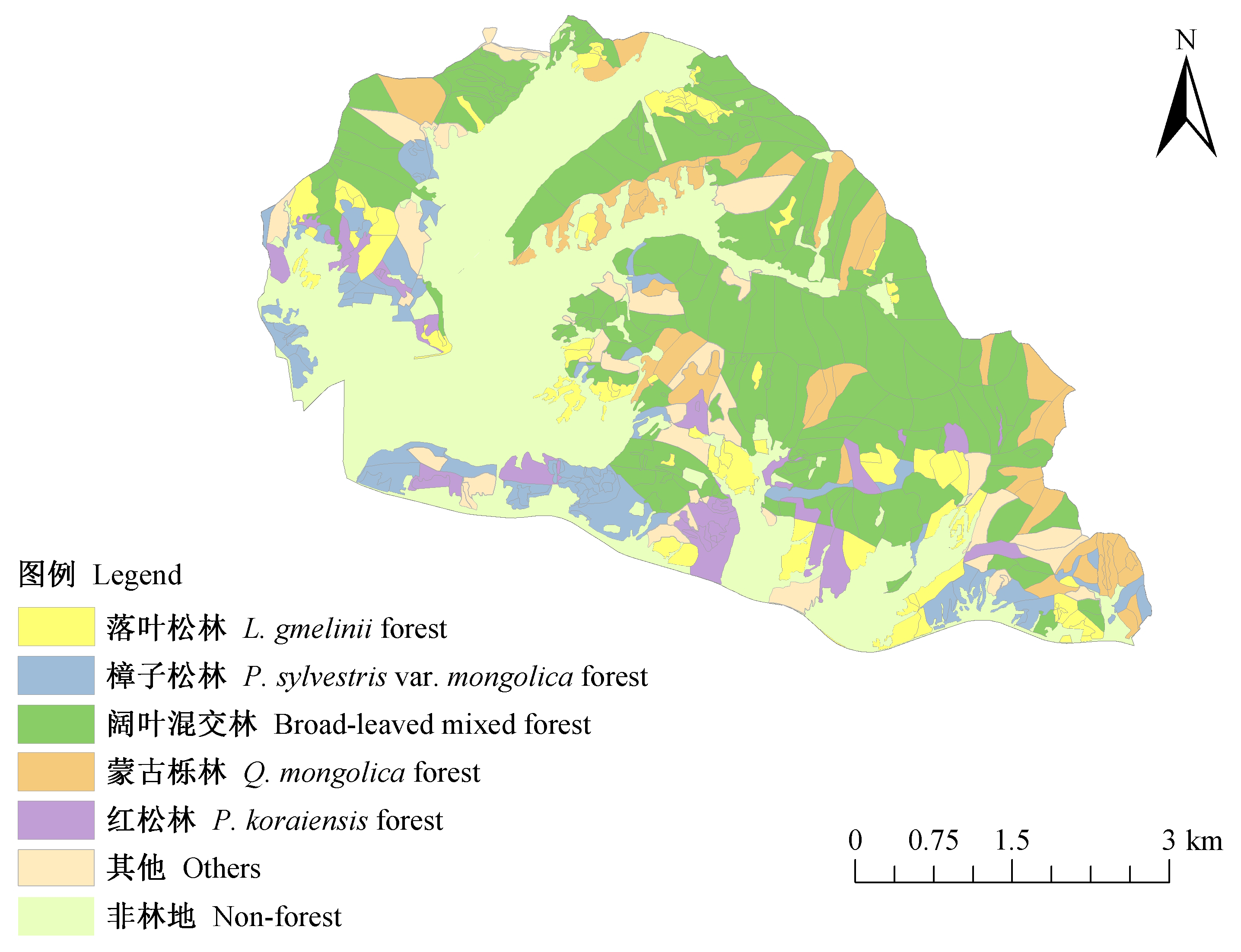
Table 1
Calculation formula of hyperspectral data extraction features"
| 特征类型 Feature type | 特征名称 Feature name | 描述或公式 Description or formula |
| 植被指数 Vegetation index | 归一化植被指数 Normalized differential vegetation index | 式中:ρNIR为近红外波段反射率,ρRED为红光波段反射率 In the formula: ρNIR is the reflectance of near-infrared band, ρRED is the reflectance of RED band |
| 增强型植被指数 Enhanced vegetation index | 式中:ρBLUE为蓝光波段反射率 In the formula: ρBLUE is the reflectance of BLUE band | |
| 比值植被指数 Ratio vegetation index | ||
| 大气阻抗植被指数 Atmospherically resistant vegetation index | ||
| 改进红边归一化植被指数 Modified red edge NDVI | 式中:ρ750为750波段反射率,ρ705为705波段反射率,ρ445为445波段反射率 In the formula: ρ750 is the reflectance of 750 band, ρ705 is the reflectance of 705 band, and ρ445 is the reflectance of 445 band | |
| 红边归一化植被指数 Red edge NDVI | ||
| 光化学反射指数 Photochemical reflectance index | 式中:ρ531为531波段反射率,ρ570为570波段反射率 In the formula: ρ531 is the reflectance of 531 band, ρ570 is the reflectance of 570 band | |
| 植物衰老反射指数 Plant senescence reflectance index | 式中:ρ680为680波段反射率,ρ500为500波段反射率 In the formula: ρ680 is the reflectance of 680 band, ρ500 is the reflectance of 500 band | |
| Vogelmann红边指数1 Vogelmann red edge index 1 | 式中:ρ740为740波段反射率,ρ720为720波段反射率 In the formula: ρ740 is the reflectance of 740 band, ρ720 is the reflectance of 720 band | |
| 水波段指数 Water band index | 式中:ρ900为900波段反射率,ρ970为970波段反射率 In the formula: ρ900 is the reflectance of 900 band, ρ970 is the reflectance of 970 band | |
| 叶绿素指数 Chlorophyll index | MERIS陆地叶绿素指数 MERIS terrestrial chlorophyll index | 式中:ρ753.75为753.75波段反射率,ρ708.75为708.75波段反射率,ρ681.25为681.25波段反射率 In the formula: ρ753.75 is the reflectance of the 753.75 band, ρ708.75 is the reflectance of the 708.75 band, and ρ681.25 is the reflectance of the 681.25 band |
| 改进的MERIS陆地叶绿素指数 Modified MTCI | 式中:ρ750为750波段反射率,ρ710为710波段反射率,ρ680为680波段反射率 In the formula: ρ750 is the reflectance of the 750 band, ρ710 is the reflectance of the 710 band, and ρ680 is the reflectance of the 680 band |
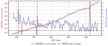
Fig.2
Rate of change of local variance"
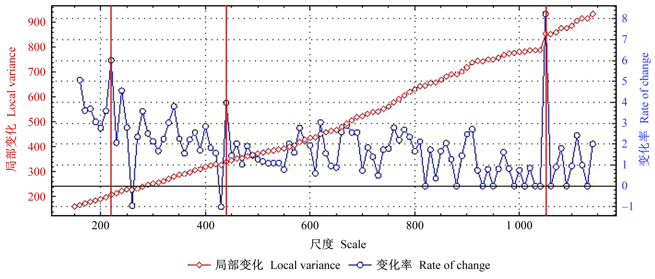
Fig.3
Image segmentation of three segmentation schemes when scale are 220 (a), 440 (b) and 1 050 (c)"
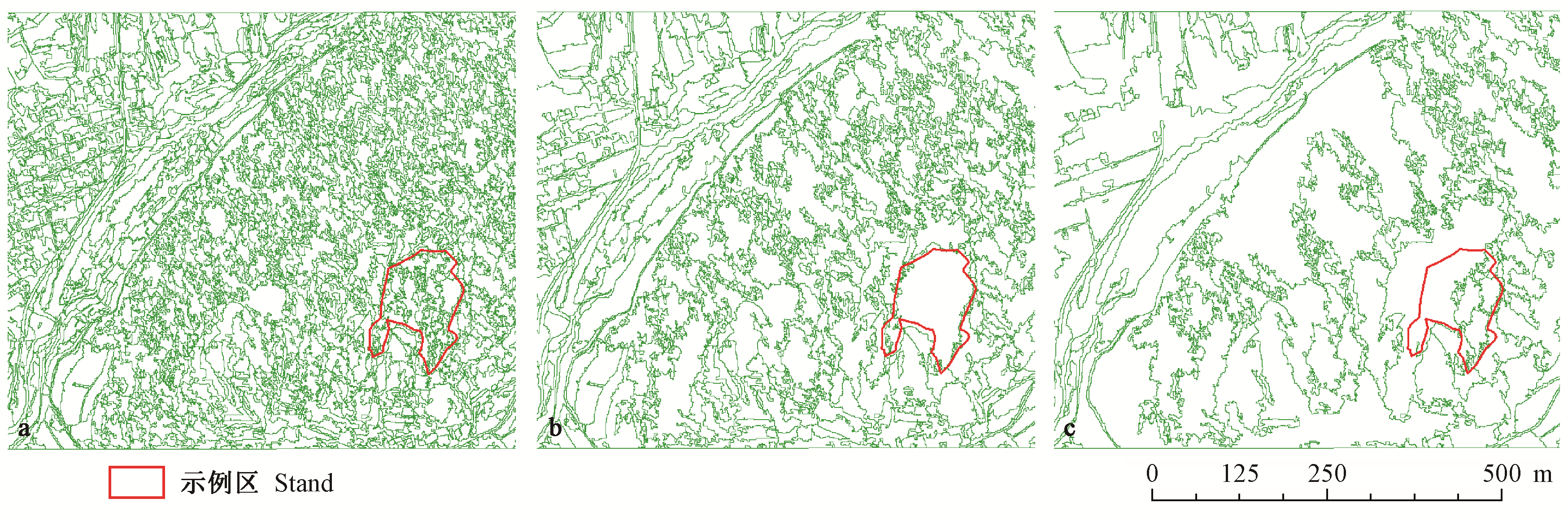
Table 2
Sample size of each stands"
| 项目 Item | 阔叶混交林 Broad-leaved mixed forest | 樟子松林 P. sylvestris var. mongolica forest | 落叶松林 L. gmelinii forest | 红松林 P. koraiensis forest | 蒙古栎林 Q. mongolica forest | 总计 Total |
| 训练样本Training sample | 1 358 | 374 | 224 | 74 | 47 | 2 077 |
| 检验样本Validation sample | 453 | 125 | 75 | 25 | 16 | 692 |
| 样本量Sample size | 1 810 | 499 | 299 | 98 | 63 | 2 769 |
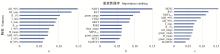
Fig.4
Importance ranking of selected features a, b and c are the characteristic variables reserved by LiDAR, hyperspectral and LiDAR+ hyperspectral respectively. AII_90% is 90% of the cumulative intensity of all echoes; H1_max is the maximum value of the first echo height; I1_1% is 1% of the first echo intensity; I_min is the minimum value of all echo intensities; I_max is the maximum value of all echo intensities; I1_cv is the deviation of the first echo intensity; I_90% is 90% of all echo intensities; H_mean is the average of all echo heights; AIH_99% is 99% of the cumulative height of all echoes; I_95% is 95% of all echo intensities; H_95% is 95% of all echo heights; green_range is the average gray value range within the convolution kernel of green band; blue_mean is the gray value of convolution kernel range in blue band; green_mean is the gray value of convolution kernel range in green band; red_range is the average gray value range within the convolution kernel of red band."
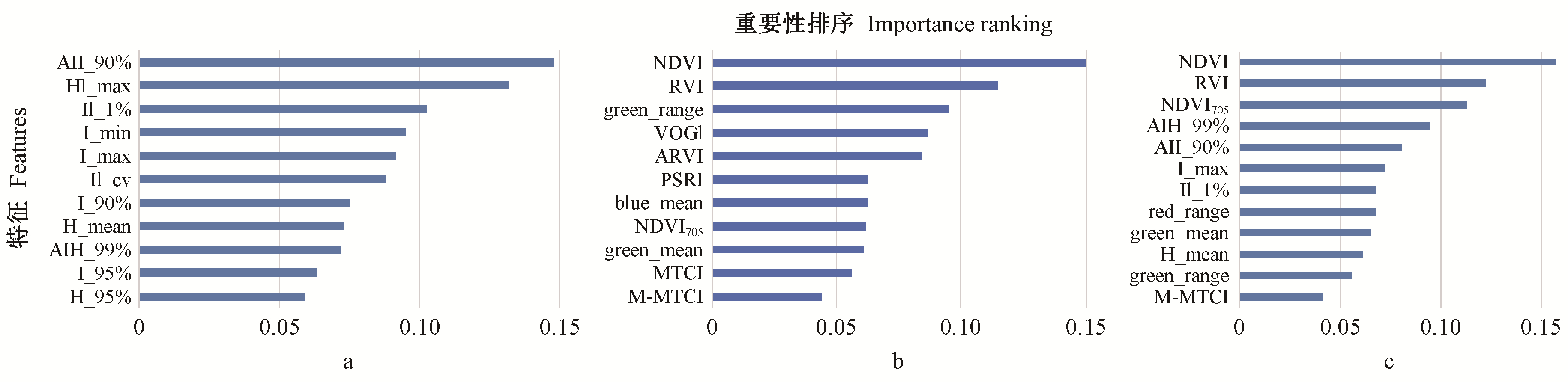
Table 3
Classification results of RF and SVM classifiers"
| 指标Indicator | 随机森林RF | 支持向量机SVM | ||||||
| 高光谱影像+激光雷达点云 Hyperspectral+ LiDAR | 高光谱影像 Hyperspectral | 激光雷达点 云LiDAR | 高光谱影像+激光雷达点云 Hyperspectral+ LiDAR | 高光谱影像 Hyperspectral | 激光雷达 点云LiDAR | |||
| 总体精度OA(%) | 88.02 | 84.13 | 76.62 | 84.42 | 82.97 | 76.19 | ||
| Kappa系数Kappa coefficient | 0.77 | 0.69 | 0.52 | 0.71 | 0.68 | 0.53 | ||
| 阔叶混交林 Broad-leaved mixed forest | 生产者精度PA (%) | 95.32 | 93.60 | 85.89 | 94.13 | 93.78 | 85.68 | |
| 用户精度UA (%) | 94.07 | 92.78 | 92.51 | 92.05 | 93.16 | 91.17 | ||
| 落叶松林 L. gmelinii forest | 生产者精度PA (%) | 76.81 | 61.54 | 52.31 | 71.67 | 62.50 | 56.36 | |
| 用户精度UA (%) | 70.67 | 46.38 | 45.33 | 57.33 | 53.33 | 41.33 | ||
| 樟子松林 P. sylvestris var. mongolica forest | 生产者精度PA (%) | 73.29 | 66.04 | 50.88 | 65.82 | 66.67 | 55.37 | |
| 用户精度UA (%) | 85.60 | 80.77 | 46.03 | 83.20 | 75.20 | 53.60 | ||
| 红松林 P. koraiensis forest | 生产者精度PA (%) | 72.22 | 66.67 | 70.59 | 76.47 | 52.38 | 45.45 | |
| 用户精度UA (%) | 54.17 | 52.17 | 50.00 | 54.17 | 45.83 | 41.67 | ||
| 蒙古栎林 Q.mongolicaforest | 生产者精度PA (%) | 81.82 | 90.91 | 87.50 | 53.33 | 47.06 | 53.85 | |
| 用户精度UA (%) | 64.29 | 71.43 | 50.00 | 50.00 | 50.00 | 43.75 | ||
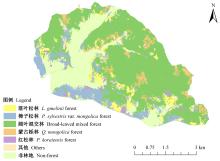
Fig.5
Classification results of multi-source data under random forest classifier"

Table 4
Effect of chlorophyll on classification results"
| 指标 Indicator | 试验组 Experimental group | 对照组 Control group |
| 总体精度Overall accuracy | 88.02 | 84.70 |
| Kappa系数Kappa coefficient | 0.77 | 0.70 |
| 陈永健. 2014. 半监督支持向量机分类方法研究. 西安: 陕西师范大学硕士学位论文. | |
| Chen Y J. 2014. Research on classification methods of semi-supervised support vector machines. Xi'an: MS thesis of Shaanxi Normal University. [in Chinese] | |
|
丁壮, 姚余君, 宋日清. 帽儿山实验林场老山地区森林资源的历史变迁. 东北林业大学学报, 2006, 34 (3): 87- 89.
doi: 10.3969/j.issn.1000-5382.2006.03.035 |
|
|
Ding Z , Yao Y J , Song R Q . Historical changes of forest resources in Laoshan area of Mao'ershan experimental forest farm. Journal of Northeast Forestry University, 2006, 34 (3): 87- 89.
doi: 10.3969/j.issn.1000-5382.2006.03.035 |
|
| 董恒, 孟庆野, 王金梁, 等. 一种改进的叶绿素提取植被指数. 红外与毫米波学报, 2012, 31 (4): 336- 341. | |
| Dong H , Meng Q Y , Wang J L , et al. An improved chlorophyll extraction vegetation index. Journal of Infrared and Millimeter Wave, 2012, 31 (4): 336- 341. | |
| 樊雪. 2016. 机载PHI高光谱数据的森林类型精细识别方法研究. 北京: 中国林业科学研究院硕士学位论文. | |
| Fan X. 2016. Research on fine recognition method of forest types based on airborne PHI hyperspectral data. Beijing: MS thesis of Chinese Academy of Forestry. [in Chinese] | |
| 皋厦, 申鑫, 代劲松, 等. 结合LiDAR单木分割和高光谱特征提取的城市森林树种分类. 遥感技术与应用, 2018, 33 (6): 1073- 1083. | |
| Gao S , Shen X , Dai J S , et al. Classification of urban forest tree species combined with LiDAR single tree segmentation and hyperspectral feature extraction. Remote Sensing Technology and Application, 2018, 33 (6): 1073- 1083. | |
|
黄衍, 查伟雄. 随机森林与支持向量机分类性能比较. 软件, 2012, 33 (6): 107- 110.
doi: 10.3969/j.issn.1003-6970.2012.06.038 |
|
|
Huang Y , Zha W X . Comparison of classification performance between random forests and support vector machine. Software, 2012, 33 (6): 107- 110.
doi: 10.3969/j.issn.1003-6970.2012.06.038 |
|
| 李波. 2017. 机载激光点云和高光谱影像融合的城市地物分类研究. 武汉: 武汉大学硕士学位论文. | |
| Li B. 2017. Classification of urban ground objects based on fusion of airborne laser point clouds and hyperspectral images. Wuhan: MS thesis of Wuhan University. [in Chinese] | |
| 李明泽, 付瑜, 于颖, 等. 基于多时相SAR数据和SPOT数据的盘古林场林分类型识别. 植物研究, 2016, 36 (4): 613- 619, 626. | |
| Li M Z , Fu Y , Yu Y , et al. Stand type identification of Pangu forest farm based on multi-temporal SAR data and SPOT data. Plant Research, 2016, 36 (4): 613- 619, 626. | |
| 刘丽娟, 庞勇, 范文义, 等. 机载LiDAR和高光谱融合实现温带天然林树种识别. 遥感学报, 2013, 17 (3): 679- 695. | |
| Liu L J , Pang Y , Fan W Y , et al. Airborne LiDAR and hyperspectral fusion for tree species identification in temperate natural forests. Journal of Remote Sensing, 2013, 17 (3): 679- 695. | |
| 刘舒, 姜琦刚, 马玥, 等. 基于多目标遗传随机森林特征选择的面向对象湿地分类. 农业机械学报, 2017, 48 (1): 119- 127. | |
| Liu S , Jiang Q G , Ma Y , et al. Object-oriented wetland classification based on multi-objective genetic random forest feature selection. Journal of Agricultural Machinery, 2017, 48 (1): 119- 127. | |
| 刘思涵, 尚夏明, 马婷. 基于随机森林特征选择的森林类型分类. 北京测绘, 2019, 33 (12): 1518- 1522. | |
| Liu S H , Shang X M , Ma T . Classification of forest types based on random forest feature selection. Beijing Mapping, 2019, 33 (12): 1518- 1522. | |
| 刘毅, 杜培军, 郑辉, 等. 基于随机森林的国产小卫星遥感影像分类研究. 测绘科学, 2012, 37 (4): 194- 196. | |
| Liu Y , Du P J , Zheng H , et al. Classification of domestic small satellite remote sensing images based on random forests. Surveying and Mapping Science, 2012, 37 (4): 194- 196. | |
|
刘怡君, 庞勇, 廖声熙, 等. 机载LiDAR和高光谱融合实现普洱山区树种分类. 林业科学研究, 2016, 29 (3): 407- 412.
doi: 10.3969/j.issn.1001-1498.2016.03.015 |
|
|
Liu Y J , Pang Y , Liao S X , et al. Airborne LiDAR and hyperspectral fusion to realize tree species classification in Pu'er mountain area. Forest Research, 2016, 29 (3): 407- 412.
doi: 10.3969/j.issn.1001-1498.2016.03.015 |
|
| 鲁续坤. 2018. 机载LiDAR和高光谱数据的树种分类及三维显示. 成都: 电子科技大学硕士学位论文. | |
| Lu X K. 2018. Tree species classification and 3D display of airborne LiDAR and hyperspectral data. Chengdu: MS thesis of University of Electronic Science and Technology. [in Chinese] | |
| 毛学刚, 魏晶昱. 基于多源遥感数据的面向对象林分类型识别. 应用生态学报, 2017, 28 (11): 3711- 3719. | |
| Mao X G , Wei J Y . Object-oriented stand type identification based on multi-source remote sensing data. Journal of Applied Ecology, 2017, 28 (11): 3711- 3719. | |
| 王婷. 2017. 高光谱遥感图像数据降维和分类算法研究. 银川: 北方民族大学硕士学位论文. | |
| Wang T. 2017. Research on dimension reduction and classification algorithms for hyperspectral remote sensing image data. Yinchuan: MS thesis of Northern University for Nationalities. [in Chinese] | |
|
温小乐, 钟奥, 胡秀娟. 基于随机森林特征选择的城市绿化乔木树种分类. 地球信息科学学报, 2018, 20 (12): 1777- 1786.
doi: 10.12082/dqxxkx.2018.180310 |
|
|
Wen X L , Zhong A , Hu X J . Classification of urban greening tree species based on random forest feature selection. Journal of Geoscience, 2018, 20 (12): 1777- 1786.
doi: 10.12082/dqxxkx.2018.180310 |
|
| 谢珠利. 2019. 基于多源高分辨率遥感数据的人工林树种分类研究. 杭州: 浙江农林大学硕士学位论文. | |
| Xie Z L. 2019. Classification of plantation tree species based on multi-source and high-resolution remote sensing data. Hangzhou: MS thesis of Zhejiang Agriculture and Forestry University. [in Chinese] | |
| 熊艳, 高仁强, 徐战亚. 机载LiDAR点云数据降维与分类的随机森林方法. 测绘学报, 2018, 47 (4): 508- 518. | |
| Xiong Y , Gao R Q , Xu Z Y . Random forest method for dimension reduction and classification of airborne LiDAR point cloud data. Acta Surveying and Mapping Sinica, 2018, 47 (4): 508- 518. | |
| 颜春燕, 牛铮, 王纪华, 等. 光谱指数用于叶绿素含量提取的评价及一种改进的农作物冠层叶绿素含量提取模型. 遥感学报, 2005, 9 (6): 742- 750. | |
| Yan C Y , Niu Z , Wang J H , et al. Spectral index for evaluation of chlorophyll content extraction and an improved model for extraction of chlorophyll content in crop canopy. Journal of Remote Sensing, 2005, 9 (6): 742- 750. | |
| 杨珺雯, 张锦水, 朱秀芳, 等. 随机森林在高光谱遥感数据中降维与分类的应用. 北京师范大学学报: 自然科学版, 2015, 51 (S1): 82- 88. | |
| Yang J W , Zhang J S , Zhu X F , et al. Application of random forests in dimension reduction and classification of hyperspectral remote sensing data. Journal of Beijing Normal University: Natural Science Edition, 2015, 51 (S1): 82- 88. | |
| 姚明煌. 2014. 随机森林及其在遥感图像分类中的应用. 厦门: 华侨大学硕士学位论文. | |
| Yao M H. 2014. Random forest and its application in remote sensing image classification. Xiamen: MS thesis of Overseas Chinese University. [in Chinese] | |
| 钟舒怡, 李向新, 柏叶辉, 等. 基于多尺度分割与光谱特征提取建成区的方法. 软件导刊, 2018, 17 (9): 180- 184. | |
| Zhong S Y , Li X X , Bai Y H , et al. A method for extracting built-up regions based on multiscale segmentation and spectral features. Software Guide, 2018, 17 (9): 180- 184. | |
|
朱凌红, 周澎, 王忠民, 等. 高光谱数据与叶绿素含量及植被指数的相关性研究进展. 内蒙古民族大学学报: 自然科学版, 2014, 29 (1): 41- 44.
doi: 10.3969/j.issn.1671-0185.2014.01.014 |
|
|
Zhu L H , Zhou P , Wang Z M , et al. Research progress on correlation of hyperspectral data with chlorophyll content and vegetation index. Journal of Inner Mongolia University for Nationalities: Natural Science Edition, 2014, 29 (1): 41- 44.
doi: 10.3969/j.issn.1671-0185.2014.01.014 |
|
|
Andersen H E , Mcgaughey R J , Reutebuch S E . Estimating forest canopy fuel parameters using LiDAR data. Remote Sensing of Environment, 2005, 94 (4): 441- 449.
doi: 10.1016/j.rse.2004.10.013 |
|
|
Asner G P , Martin R E . Canopy phylogenetic, chemical and spectral assembly in a lowland Amazonian forest. New Phytol, 2011, 189 (4): 999- 1012.
doi: 10.1111/j.1469-8137.2010.03549.x |
|
| Clément D , Clément M , Arnaud L B , et al. Semantic segmentation of forest stands of pure species combining airborne LiDAR data and very high resolution multispectral imagery. ISPRS Journal of Photogrammetry and Remote Sensing, 2018, 126, 129- 145. | |
| Cortes C , Vapnik V . Support-vector networks. Machine Learning, 1955, 20, 273- 297. | |
| Dash J , Curran P J . The MERIS terrestrial chlorophyll index. International Journal of Remote Sensing, 2004, 25 (23): 5003- 5013. | |
|
Lefsky M A , Cohen W B , Parker G G , et al. LiDAR remote sensing for ecosystem studies. BioScience, 2002, 52 (1): 19- 30.
doi: 10.1641/0006-3568(2002)052[0019:LRSFES]2.0.CO;2 |
|
|
Mountrakis M J , Ogole C . Support vector machines in remote sensing: a review. ISPRS Journal of Photogrammetry and Remote Sensing, 2011, 66 (3): 247- 259.
doi: 10.1016/j.isprsjprs.2010.11.001 |
|
|
Shi Y F , Andrew K S , Tiejun W , et al. Tree species classification using plant functional traits from LiDAR and hyperspectral data. International Journal of Applied Earth Observation and Geoinformation, 2018, 73, 207- 219.
doi: 10.1016/j.jag.2018.06.018 |
|
|
Wulder M A , Hall R J , Coops N C , et al. High spatial resolution remotely sensed data for ecosystem characterization. BioScience, 2004, 54 (6): 511- 521.
doi: 10.1641/0006-3568(2004)054[0511:HSRRSD]2.0.CO;2 |
|
|
Zhao Y J , Zeng Y , Zheng Z J , et al. Forest species diversity mapping using airborne LiDAR and hyperspectral data in a subtropical forest in China. Remote Sensing of Environment, 2018, 213, 104- 114.
doi: 10.1016/j.rse.2018.05.014 |
| [1] | Ying Pan,Mingming Ding,Jie Lin,Qiao Dai,Geng Guo,Linlin Cui. Inversion of Forest Leaf Area Index Based on PROSAIL Model and Multi-Angle Remote Sensing Data [J]. Scientia Silvae Sinicae, 2021, 57(4): 90-106. |
| [2] | Langning Huo,Xiaoli Zhang. Individual Tree Information Extraction and Accuracy Evaluation Based on Airborne LiDAR Point Cloud by Multilayer Clustering Method [J]. Scientia Silvae Sinicae, 2021, 57(1): 85-94. |
| [3] | Fang Chen,Xianbao Cheng,Anmin Huang,Xueshun Wang. Elastic Modulus Prediction of Cunninghamia lanceolata Based on Artificial Bee Colony Algorithm SVM and NIR [J]. Scientia Silvae Sinicae, 2021, 57(1): 161-168. |
| [4] | Dakun Lin,Shiguo Huang,Feiping Zhang,Guanghong Liang,Songqing Wu,xia Hu,Rong Wang. Method of Image Recognition for Lepidopteran Insects Based on Improved Differential Evolution Algorithm [J]. Scientia Silvae Sinicae, 2020, 56(3): 73-81. |
| [5] | Lin Zhao,Xiaoli Zhang,Yanshuang Wu,Bin Zhang. Subtropical Forest Tree Species Classification Based on 3D-CNN for Airborne Hyperspectral Data [J]. Scientia Silvae Sinicae, 2020, 56(11): 97-107. |
| [6] | Chuan Jin,Tianshan Zha,Xin Jia,Yun Tian,Wenjun Zhou,Tengzhou Wei. Light Energy Partitioning, Photoprotection and Influencing Factors of PhotosystemⅡ in an Exotic Species (Salix psammophila) in Mu Us Sandy Land [J]. Scientia Silvae Sinicae, 2020, 56(10): 34-44. |
| [7] | Xusheng Li,Hu Li,Donghua Chen,Yufeng Liu,Saisai Liu,Congfang Liu,Guoqing Hu. Multiple Classifiers Combination Method for Tree Species Identification Based on GF-5 and GF-6 [J]. Scientia Silvae Sinicae, 2020, 56(10): 93-104. |
| [8] | Xiangqian Wu,Lin Cao,Xin Shen,Guibin Wang,Fuliang Cao. Estimation of Effective Leaf Area Index Using UAV-Based LiDAR in Ginkgo Plantations [J]. Scientia Silvae Sinicae, 2020, 56(1): 74-86. |
| [9] | Xia Yongjie, Pang Yong, Liu Luxia, Chen Bowei, Dong Bin, Huang Qingfeng. Forest Height Growth Monitoring of Cunninghamia lanceolata Plantation Using Multi-Temporal Aerial Photography with the Support of High Accuracy DEM [J]. Scientia Silvae Sinicae, 2019, 55(4): 108-121. |
| [10] | Liu Junxiang, Yu Yongchang, Lang Pengpeng, Sun Zhenyuan. Radical Heterogeneity of Photochemical Characteristics of Chloroplasts in Current-year Twigs of Salix matsudana [J]. Scientia Silvae Sinicae, 2019, 55(3): 36-42. |
| [11] | Wang Haoyun, Wu Feng, Zhu Xiaokun, Xie Weibin. Effects of Leaf Types on Growth and Chlorophyll Fluorescence Characteristics in Pinus massoniana Seedlings [J]. Scientia Silvae Sinicae, 2019, 55(3): 183-192. |
| [12] | Lingyan Chen,Dejin Xie,Jundong Rong,Jinli Lai,Xueling Lin,Yushan Zheng. Effects of Photosynthetic Pigment Content on Photosynthetic Characteristics of Different Leaf Color Phenotypes of Sinobambusa tootsik f. luteoloalbostriata [J]. Scientia Silvae Sinicae, 2019, 55(12): 21-31. |
| [13] | Han Zongtao, Jiang Hong, Wang Wei, Li Zengyuan, Chen Erxue, Yan Min, Tian Xin. Forest Above-Ground Biomass Estimation Using KNN-FIFS Method Based on Multi-Source Remote Sensing Data [J]. Scientia Silvae Sinicae, 2018, 54(9): 70-79. |
| [14] | Geng Lin, Li Mingze, Fan Wenyi, Wang Bin. Individual Tree Structure Parameters and Effective Crown of the Stand Extraction Base on Airborn LiDAR Data [J]. Scientia Silvae Sinicae, 2018, 54(7): 62-72. |
| [15] | You Haotian, Xing Yanqiu, Peng Tao, Ding Jianhua. Research on the Effect of Side-Overlap between Airborne LiDAR Adjacent Swaths on the Coniferous Forest Structural Parameters Estimation [J]. Scientia Silvae Sinicae, 2018, 54(6): 109-118. |
| Viewed | ||||||
|
Full text |
|
|||||
|
Abstract |
|
|||||