
Scientia Silvae Sinicae ›› 2025, Vol. 61 ›› Issue (6): 13-24.doi: 10.11707/j.1001-7488.LYKX20240525
• Special subject: Smart forestry • Previous Articles Next Articles
Jiamin Wu1,2,3,Yaxin Wang2,3,Bin Sun2,3,*( ),Zhijie Ma4,Weina Sun5,Liang Hong1
Received:2024-09-09
Online:2025-06-10
Published:2025-06-26
Contact:
Bin Sun
E-mail:sunbin@ifrit.ac.cn
CLC Number:
Jiamin Wu,Yaxin Wang,Bin Sun,Zhijie Ma,Weina Sun,Liang Hong. Remote Sensing Estimation of Biomass of Caragana korshinskii with UAV[J]. Scientia Silvae Sinicae, 2025, 61(6): 13-24.

Fig.1
Research area plot distribution and UAV flight zone"
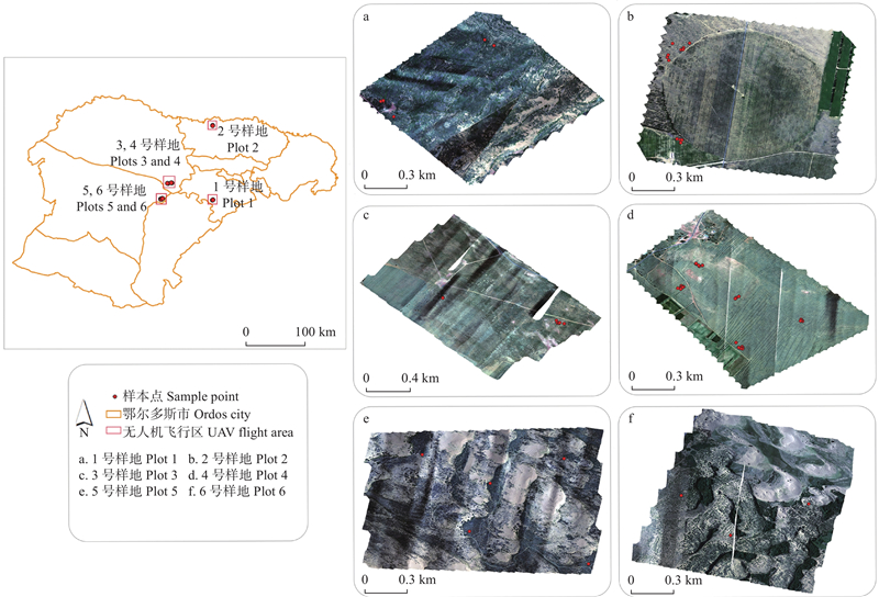
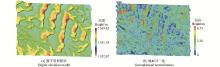
Fig.2
Preprocessing of LiDAR point cloud data"
Table 1
Feature variables involved in the selection process"
| 变量类型 Variable type | 变量名称 Variable name | 变量描述 Variable description |
| 平面特征 Planar features | Area | 面积 Area |
| Perimeter | 周长 Perimeter | |
| 高度变量 Height variable | H_aad_z | 高度平均绝对偏差 Average absolute deviation of height |
| H_canopy_ relief_ratio | 冠层起伏率 Canopy height fluctuation rate | |
| H_AIH_1st...99th | 累积高度百分位数(AIH,15个) Cumulative height percentile (AIH,15) | |
| H_AIH_IQ | 累积高度百分位数(AIH) 四分位数间距 Cumulative height percentile quartile spacing | |
| H_curt_mean_cube | 三次幂平均 Average height of cubic power | |
| H_cv_z | 二次幂平均 Average value of height quadratic power | |
| H_IQ | 高度百分位数四分位数间距 Height percentile quartile spacing | |
| H_kurtosis | 峰度 Height kurtosis | |
| H_madmedian | 中位数绝对偏差的中位数 Median of absolute deviation of height median | |
| H_max | 最大值 Maximum | |
| H_min | 最小值 Minimum | |
| H_mean | 平均值 Average | |
| H_median_z | 中位数 Median | |
| H_percentile_ 1st...99th | 高度百分位数(15个) Height percentile (15) | |
| H_skewness | 偏斜度(偏态) Height skewness (skewness) | |
| H_sqrt_mean_sq | 标准差 Standard deviation | |
| H_stddev | 方差 Variance | |
| H_variance | 变异系数 Coefficient of variation | |
| 密度变量 Density variable | density_ metrics[0]-[9] | 密度变量(10个) Density variable (10) |
| 强度变量 Intensive variable | int_aad | 平均绝对偏差 Average absolute deviation of intension |
| int_cv | 标准差 Standard deviation | |
| int_AII_1st...99th | 累积强度百分位数(AII,15个) Cumulative intension percentiles (AII,15) | |
| int_kurtosis | 峰值 Peak intension | |
| int_madmedian | 中位数绝对偏差的中位数 Median of absolute deviation of median intension | |
| int_max | 最大值 Maximum | |
| int_min | 最小值 Minimum | |
| int_mean | 平均值 Average | |
| int_median_z | 中位数 Median | |
| int_skewness | 偏斜度 Skewness | |
| int_variance | 变异系数 Coefficient of variation | |
| int_stddev | 方差 Variance | |
| int_percentile_ 1st...99th | 强度百分位数(15个) Intension percentiles (15) | |
| int_con_iq | 强度百分位数四分位数间距 Intension percentile quartile spacing |

Fig.3
Extraction of C.korshinskii"
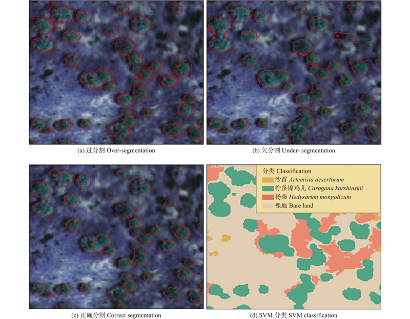
Table 2
Extraction accuracy of individual plant segmentation based on LSMS"
| 样方号 Quadrat number | 灌木数 Number of shrubs | 正确分割 Correctly segmented | 过分割 Over-segmented | 欠分割 Under-segmented | 准确率 Accuracy rate (%) | 过分割误差 Commission error (%) | 欠分割误差 Omission error (%) |
| A1 | 331 | 306 | 11 | 14 | 92.45 | 3.32 | 4.23 |
| 2 | 141 | 122 | 8 | 11 | 86.52 | 5.67 | 7.80 |
| 3 | 106 | 96 | 3 | 7 | 90.57 | 2.83 | 6.60 |
| 4 | 366 | 338 | 15 | 13 | 92.35 | 4.10 | 3.55 |
| 5 | 111 | 98 | 8 | 5 | 88.29 | 7.21 | 4.50 |
| 6 | 265 | 236 | 9 | 20 | 89.06 | 3.40 | 7.55 |
| 总样方 Total samples | A1320 | 54 | 70 | 90.61 | 4.09 | 5.30 |
Table 3
Verification of classification accuracy based on SVM"
| 类别 Class | 制图精度 Mapping accuracy(%) | 用户精度 User accuracy(%) | 总体精度 Overall accuracy(%) | Kappa 系数 Kappa coefficient |
| 沙蒿 Artemisia desertorum | 90.42 | 91.64 | 91.51 | 0.86 |
| 沙柳 Salix psammophila | 82.50 | 74.85 | ||
| 柠条锦鸡儿 Caragana korshinskii | 95.07 | 98.46 | ||
| 杨柴 Hedysarum mongolicum | 87.53 | 86.67 | ||
| 裸地 Bare land | 99.32 | 100 |
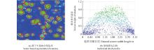
Fig.4
Extraction of point cloud information from individual shrub"
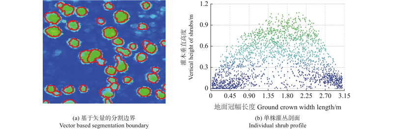
Fig.5
Extraction of individual shrub height percentile and cumulative height percentile"
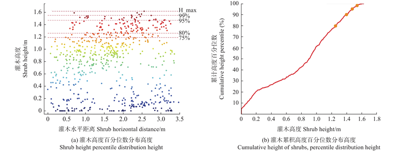
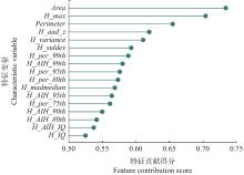
Fig.6
Contribution score of screening results to biomass modeling"
Table 4
RF, SVR and XGBoost model inversion accuracy"
| 模型 Model | 决定系数 R2 | 均方根误差 RMSE/g | 平均绝对误差 MAE/g |
| RF | 0.83 | 479.59 | 390.48 |
| SVR | 0.88 | 403.73 | 313.77 |
| XGBoost | 0.95 | 259.57 | 157.51 |
Fig.7
Residual comparison of RF, SVR, and XGBoost models"
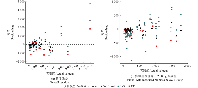
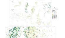
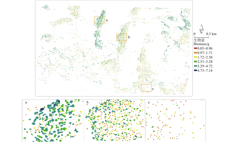
Fig.8
XGBoost model’s biomass prediction and partial enlargement of plot No. 5"
| 鲍莉莉, 李锦荣, 韩兆恩, 等. 基于无人机多源数据的梭梭(Holoxylon ammodendron)地上生物量估算. 中国沙漠, 2024, 44 (5): 50- 59. | |
| Bao L L, Li J R, Han Z E, et al. Estimation of aboveground biomass of Haloxylon ammodendron based on UAV multi-source data. Journal of Desert Research, 2024, 44 (5): 50- 59. | |
|
包栎炀, 王祥军, 李少达, 等. 基于无人机LiDAR的橡胶树单木地上生物量估测. 热带作物学报, 2023, 44 (6): 1266- 1275.
doi: 10.3969/j.issn.1000-2561.2023.06.020 |
|
|
Bao L Y, Wang X J, Li S D, et al. Estimation of individual tree above-ground biomass of rubber tree based on UAV-LiDAR. Chinese Journal of Tropical Crops, 2023, 44 (6): 1266- 1275.
doi: 10.3969/j.issn.1000-2561.2023.06.020 |
|
|
陈日强, 李长春, 杨贵军, 等. 无人机机载激光雷达提取果树单木树冠信息. 农业工程学报, 2020, 36 (22): 50- 59.
doi: 10.11975/j.issn.1002-6819.2020.22.006 |
|
|
Chen R Q, Li C C, Yang G J, et al. Extraction of crown information from individual fruit tree by UAV LiDAR. Transactions of the Chinese Society of Agricultural Engineering, 2020, 36 (22): 50- 59.
doi: 10.11975/j.issn.1002-6819.2020.22.006 |
|
| 陈星京, 冯林艳, 张宇超, 等. 基于机载激光雷达的崇礼冬奥核心区林分地上生物量反演. 林业科学, 2022, 58 (10): 35- 46. | |
| Chen X J, Feng L Y, Zhang Y C, et al. Inversion of aboveground biomass in the core area of Chongli winter olympics based on airborne LiDAR. Scientia Silvae Sinicae, 2022, 58 (10): 35- 46. | |
|
党晓宏, 高 永, 蒙仲举, 等. 西鄂尔多斯地区5种荒漠优势灌丛生物量分配格局及预测模型. 中国沙漠, 2017, 37 (1): 100- 108.
doi: 10.7522/j.issn.1000-694X.2015.00201 |
|
|
Dang X H, Gao Y, Meng Z J, et al. Biomass allocation patterns and estimation model of five desert shrub species in West Ordos Region. Journal of Desert Research, 2017, 37 (1): 100- 108.
doi: 10.7522/j.issn.1000-694X.2015.00201 |
|
|
丁家祺, 黄文丽, 刘迎春, 等. 基于机器学习和多源数据的湘西北森林地上生物量估测. 林业科学, 2021, 57 (10): 36- 48.
doi: 10.11707/j.1001-7488.20211004 |
|
|
Ding J Q, Huang W L, Liu Y C, et al. Estimation of forest aboveground biomass in northwest Hunan Province based on machine learning and multi-source data. Scientia Silvae Sinicae, 2021, 57 (10): 36- 48.
doi: 10.11707/j.1001-7488.20211004 |
|
| 杜中曼, 马文明, 周青平, 等. 基于遥感技术的植被识别方法研究进展. 生态科学, 2022, 41 (6): 222- 229. | |
| Du Z M, Ma W M, Zhou Q P, et al. Research progress of vegetation recognition methods based on remote sensing technology. Ecological Science, 2022, 41 (6): 222- 229. | |
| 高宏元, 侯蒙京, 葛 静, 等. 基于随机森林的高寒草地地上生物量高光谱估算. 草地学报, 2021, 29 (8): 1757- 1768. | |
| Gao H Y, Hou M J, Ge J, et al. Hyperspectral estimation of aboveground biomass of alpine grassland based on random forest algorithm. Acta Agrestia Sinica, 2021, 29 (8): 1757- 1768. | |
| 郭玉东, 张秋良, 陈晓燕, 等. 库布齐沙漠地区人工灌木林生物量模型构建. 西北农林科技大学学报(自然科学版), 2022, 50 (4): 74- 82. | |
| Guo Y D, Zhang Q L, Chen X Y, et al. Establishment of biomass models for artificial shrubbery in the Kubuqi desert area. Journal of Northwest A& F University (Natural Science Edition), 2022, 50 (4): 74- 82. | |
| 郝 君, 吕康婷, 胡天祺, 等. 基于机器学习的红树林生物量遥感反演研究. 林草资源研究, 2024, (1): 65- 72. | |
| Hao J, Lü K T, Hu T Q, et al. Remote sensing inversion of mangrove biomass based on machine learning. Forest and Grassland Resources Research, 2024, (1): 65- 72. | |
|
胡中洋, 陕 亮, 陈翔宇, 等. CHM与DSM相结合的无人机激光雷达单木分割. 林业科学, 2024, 60 (8): 14- 24.
doi: 10.11707/j.1001-7488.LYKX20230079 |
|
|
Hu Z Y, Shan L, Chen X Y, et al. Individual tree segmentation of UAV-LiDAR based on the combination of CHM and DSM. Scientia Silvae Sinicae, 2024, 60 (8): 14- 24.
doi: 10.11707/j.1001-7488.LYKX20230079 |
|
| 黄毅豪. 2023. 基于机器学习的珠江口CDOM反演模型研究. 南昌: 江西师范大学. | |
| Huang Y H. 2023. Investigation on remote sensing algorithm of Chromophoric Dissolved Organic Matter (CDOM) in the pearl river estuary with machine learning methodology. Nanchang: Jiangxi Normal University. [in Chinese] | |
| 金学娟. 2023. 基于非线性联立方程系统的柠条生物量动态模型研究. 银川: 宁夏大学. | |
| Jin X J. 2023. Study on dynamic models for Caragana korshinskii biomass based on nonlinear simultaneous equation system. Yinchuan: Ningxia University. [in Chinese] | |
| 李增元, 刘清旺, 庞 勇. 激光雷达森林参数反演研究进展. 遥感学报, 2016, 20 (5): 1138- 1150. | |
| Li Z Y, Liu Q W, Pang Y. Review on forest parameters inversion using LiDAR. Journal of Remote Sensing, 2016, 20 (5): 1138- 1150. | |
| 李志杰, 黄 兵, 雷建国. 2019. 影响机载激光雷达点云密度的因素分析. 测绘科学, 44(6): 204-211. | |
| Li Z J, Huang B, Lei J G, 2019. Analysis of the factors affecting point cloud density of airborne LiDAR. Science of Surveying and Mapping, 44(6): 204-211. [in Chinese] | |
| 刘晓亮, 隋立春, 白永飞, 等. 地基激光雷达灌丛化草原小叶锦鸡儿生物量估算. 遥感学报, 2020, 24 (7): 894- 903. | |
| Liu X L, Sui L C, Bai Y F, et al. Biomass estimation of Caragana microphylla in the shrub encroached grassland based on terrestrial laser scanning. Journal of Remote Sensing, 2020, 24 (7): 894- 903. | |
|
吕梓晴, 段爱国. 不同产区杉木生物量与碳储量模型. 林业科学, 2024, 60 (2): 1- 11.
doi: 10.11707/j.1001-7488.LYKX20220526 |
|
|
Lü Z Q, Duan A G. Biomass and carbon storage model of Cunninghamia lanceolata in different production areas. Scientia Silvae Sinicae, 2024, 60 (2): 1- 11.
doi: 10.11707/j.1001-7488.LYKX20220526 |
|
| 马 强, 张 梁, 宋俊峰, 等. 关于鄂尔多斯市鄂托克旗林草生态建设“先建后补”合同制管理模式的调研与思考. 内蒙古林业, 2024, (1): 7- 10. | |
| Ma Q, Zhang L, Song J F, et al. Research and reflection on the contract management model of “Build First, Supplement Later” for ecological construction of forests and grasslands in Etuoke Banner, Ordos City. Inner Mongolia Forestry, 2024, (1): 7- 10. | |
| 马 苏, 刘军会, 康玉麟, 等. 鄂尔多斯市防风固沙功能时空变化及驱动因素分析. 环境科学研究, 2022, 35 (11): 2477- 2485. | |
| Ma S, Liu J H, Kang Y L, et al. Spatio-temporal changes of sand-fixing function and its driving factors in the Ordos. Research of Environmental Sciences, 2022, 35 (11): 2477- 2485. | |
| 毛英伍, 郭 颖 , 张王菲, 等. 联合LiDAR、高光谱数据及3D-CNN方法的树种分类. 林业科学, 2023, 59 (3): 73- 83. | |
| Mao Y W, Guo Y, Zhang W F, et al. Tree species classification by combining LiDAR, hyperspectral data and 3D-CNN method. Scientia Silvae Sinicae, 2023, 59 (3): 73- 83. | |
| 潘 霞. 2022. 基于Google Earth Engine云平台下地物覆被类型的遥感影像智能分类方法研究. 呼和浩特: 内蒙古农业大学. | |
| Pan X. 2022. Research on intelligent classification method of remote sensing image for land cover types based on Google Earth Engine cloud platform. Huhehaote: Inner Mongolia Agriculture University. [in Chinese] | |
| 戎 荣. 2023. 锡林郭勒草原小叶锦鸡儿灌丛地上生物量遥感估算研究. 太原: 山西大学. | |
| Rong R. 2023. Study on above-ground biomass estimation of Caragana microphylla shrub in Xilingol grassland by remote sensing. Taiyuan: Shanxi University. [in Chinese] | |
| 谭雨欣, 田义超, 黄卓梅, 等. 基于XGBoost机器学习算法的北部湾茅尾海无瓣海桑红树林地上生物量反演. 生态学报, 2023, 43 (11): 1- 15. | |
| Tan Y X, Tian Y C, Huang Z M, et al. Aboveground biomass of Sonneratia apetala mangroves in Mawei Sea of Beibu Gulf based on XGBoost machine leaming algorithm. Acta Fcologica Sinica, 2023, 43 (11): 1- 15. | |
| 王 婷, 周 伟, 肖洁芸, 等. 基于遥感数据和机器学习算法的草地地上生物量估算研究. 冰川冻土, 2023, 45 (2): 753- 762. | |
| Wang T, Zhou W, Xiao J Y, et al. Estimating the grassland aboveground biomass based on remote sensing data and machine learning algorithm. Journal of Glaciology and Geocryology, 2023, 45 (2): 753- 762. | |
| 杨爱霞, 丁建丽, 2015. 新疆艾比湖湿地土壤有机碳含量的光谱测定方法对比. 农业工程学报, 31(18): 162−168. | |
| Yang A X, Ding J L, 2015. Comparative assessment of two methods for estimation of soil organic carbon content by Vis-NIR spectra in Xinjiang Ebinur Lake Wetland. Transactions of the Chinese Society of Agricultural Engineering, 31(18): 162−168. [in Chinese] | |
|
张亦然, 刘廷玺, 童 新, 等. 基于XGBoost算法的草甸地上生物量的高光谱遥感反演. 草业学报, 2021, 30 (4): 1- 12.
doi: 10.11686/cyxb2020190 |
|
|
Zhang Y R, Liu T X, Tong X, et al. Hyperspectral remote sensing inversion of meadow aboveground biomass based on an XGBoost algorithm. Acta Prataculturae Sinica, 2021, 30 (4): 1- 12.
doi: 10.11686/cyxb2020190 |
|
| 张振西, 林扎西尖措, 华旦仁青, 等. 天峻县草地地上生物量遥感监测模型. 草原与草坪, 2023, 43 (3): 39- 45. | |
| Zhang Z X, Lin Z X J Z, Hua D R Q, et al. Remote sensing monitoring model for above ground biomass of grassland in Tianjun County. Grassland and Turf, 2023, 43 (3): 39- 45. | |
|
Anderson K E, Glenn N F, Spaete L P, et al. Estimating vegetation biomass and cover across large plots in shrub and grass dominated drylands using terrestrial lidar and machine learning. Ecological Indicators, 2018, 84, 793- 802.
doi: 10.1016/j.ecolind.2017.09.034 |
|
| Bar-On Y M, Phillips R, Milo R. The biomass distribution on Earth. Proceedings of the National Academy of Sciences of the United States of America, 2018, 115 (25): 6506- 6511. | |
|
Chen L, Xing M F, He B B, et al. Estimating soil moisture over winter wheat fields during growing season using machine-learning methods. IEEE Journal of Selected Topics in Applied Earth Observations and Remote Sensing, 2021, 14, 3706- 3718.
doi: 10.1109/JSTARS.2021.3067890 |
|
|
Du L M, Pang Y, Wang Q, et al. A LiDAR biomass index-based approach for tree- and plot-level biomass mapping over forest farms using 3D point clouds. Remote Sensing of Environment, 2023, 290, 113543.
doi: 10.1016/j.rse.2023.113543 |
|
|
Estornell J, Ruiz L A, Velázquez-Martí B, et al. Estimation of shrub biomass by airborne LiDAR data in small forest stands. Forest Ecology and Management, 2011, 262 (9): 1697- 1703.
doi: 10.1016/j.foreco.2011.07.026 |
|
|
Jia Z Y, Zhang Z H, Cheng Y X, et al. Grassland biomass spatiotemporal patterns and response to climate change in eastern Inner Mongolia based on XGBoost model estimates. Ecological Indicators, 2024, 158, 111554.
doi: 10.1016/j.ecolind.2024.111554 |
|
| Li Z, Ding J, Zhang H, et al, 2021. Classifying individual shrub species in UAV images—a case study of the Gobi Region of Northwest China. Remote Sensing, 13(24): 4995. | |
|
Mitra A, Sengupta K, Banerjee K. Standing biomass and carbon storage of above-ground structures in dominant mangrove trees in the Sundarbans. Forest Ecology and Management, 2011, 261 (7): 1325- 1335.
doi: 10.1016/j.foreco.2011.01.012 |
|
|
Morais T G, Teixeira R F M, Figueiredo M, et al. The use of machine learning methods to estimate aboveground biomass of grasslands: a review. Ecological Indicators, 2021, 130, 108081.
doi: 10.1016/j.ecolind.2021.108081 |
|
|
Pang Y, Wang W W, Du L M, et al. Nyström-based spectral clustering using airborne LiDAR point cloud data for individual tree segmentation. International Journal of Digital Earth, 2021, 14 (10): 1452- 1476.
doi: 10.1080/17538947.2021.1943018 |
|
|
Prošek J, Petra Š. UAV for mapping shrubland vegetation: does fusion of spectral and vertical information derived from a single sensor increase the classification accuracy?. International Journal of Applied Earth Observation and Geoinformation, 2019, 75, 151- 162.
doi: 10.1016/j.jag.2018.10.009 |
|
| Tamiminia H, Salehi B, Mahdianpari M, et al. 2021. Random forest outperformed convolutional neural networks for shrub willow above ground biomass estimation using multi-spectral UAS imagery. 2021 IEEE International Geoscience and Remote Sensing Symposium IGARSS, 8269-8272. | |
|
Teshome F T, Bayabil H K, Hoogenboom G, et al. Unmanned aerial vehicle (UAV) imaging and machine learning applications for plant phenotyping. Computers and Electronics in Agriculture, 2023, 212, 108064.
doi: 10.1016/j.compag.2023.108064 |
|
| Vapnik V, Golowich S, Smola A. 1996. Support vector method for function approximation, regression estimation and signal processing. Proceedings of the 9th International Conference on Neural Information Processing Systems. Cambridge, MA, USA: MIT Press: 281-287. | |
|
Xu H, Wang Z J, Li Y, et al. Dynamic growth models for Caragana korshinskii shrub biomass in China. Journal of Environmental Management, 2020, 269, 110675.
doi: 10.1016/j.jenvman.2020.110675 |
|
|
Xu Y H, Ghamisi P. Consistency-regularized region-growing network for semantic segmentation of urban scenes with point-level Annotations. IEEE Transactions on Image Processing, 2022, 31, 5038- 5051.
doi: 10.1109/TIP.2022.3189825 |
|
|
Yao X L, Yang G J, Wu B, et al. Biomass estimation models for six shrub species in Hunshandake Sandy Land in Inner Mongolia, Northern China. Forests, 2021, 12 (2): 167.
doi: 10.3390/f12020167 |
|
|
Yue W, Gao Z H, Sun B, et al. Sample plot design can affect the efficiency and accuracy of shrub coverage measurements in shrub-encroached grasslands. CATENA, 2023, 233, 107533.
doi: 10.1016/j.catena.2023.107533 |
| [1] | Ying Quan,Guofan Shao,Mingze Li. From Empirical Models to Intelligent Estimation: An Innovation Pathway of Remote Sensing Technology in Monitoring Forest Carbon Stocks in Northeast China [J]. Scientia Silvae Sinicae, 2026, 62(6): 236-248. |
| [2] | Yunhe Li,Sirong Wang,Yisa Li,Dengsheng Lu. Comparative Analysis of Individual Tree Parameter Extraction Accuracy Using Integrated Data Collected by Airborne and Handheld LiDAR in Subtropical Typical Forests [J]. Scientia Silvae Sinicae, 2026, 62(6): 82-95. |
| [3] | Shimei Xiong,Bingxiang Tan,Wenqiang Xu,Xiaoyao Li,Lifeng Pang,Bing Hu. Estimation of Aboveground Biomass in Desert Haloxylon ammodendron Shrubland Based on UAV Multispectral and LiDAR Data [J]. Scientia Silvae Sinicae, 2026, 62(6): 96-108. |
| [4] | Qun Zheng,Yipu Li,Zhongyuan Su,Yonglin Zheng,Yunqi Wang. Acid Deposition Intensifies the Impacts of Land Use Change on the Spatiotemporal Heterogeneity of Soil Retention in the Chongqing Section of the Three Gorges Reservoir [J]. Scientia Silvae Sinicae, 2026, 62(5): 40-53. |
| [5] | Yining Lian,Hao Lu,Yongjian Huai,Haifeng Xu,Langning Huo,Zhichao Wang. Point Cloud Semantic-Guided Individual Tree Segmentation and Parameter Estimation Using UAV Laser Scanning [J]. Scientia Silvae Sinicae, 2026, 62(4): 106-117. |
| [6] | Wenqiang Gao,Xiangdong Lei,Xiao He,Yutang Li. Variability in Tree Species Diversity-Aboveground Biomass Relationship in Temperate Forest Types and Developmental Stages in Northeast China [J]. Scientia Silvae Sinicae, 2026, 62(4): 55-67. |
| [7] | Weisheng Zeng,Xuexiang Wen,Han Fu,Xiangnan Sun,Kangmei Lü,Qiangyi Liu,Tian Wang. Establishment and Application of Simultaneous Models for Estimating Major Stand Characteristics in Beijing Based on LiDAR Data [J]. Scientia Silvae Sinicae, 2026, 62(4): 68-80. |
| [8] | Min Deng,Huaijiang He,Xiangju Wu,Xinna Zhang,Chunyu Zhang,Xiuhai Zhao. Effects of Biomass Allocation Trade-Offs and Traits of Temperate Forests in Northeast China on Seedling Growth [J]. Scientia Silvae Sinicae, 2026, 62(3): 48-60. |
| [9] | Sheng Zhou,Fugen Jiang,Shuai Chen,Yi Long,Binbin Wang,Zige Song,Hua Sun. Estimation of Forest Aboveground Biomass Using Joint Spaceborne-UAV LiDAR and Sentinel-2 Data [J]. Scientia Silvae Sinicae, 2026, 62(3): 74-87. |
| [10] | Yuwei Zhang,Mengting Mo,Bo Shu,Jiajia Yao,Zhilin Yuan. Fungal Elicitors Promote Flavonoid Biosynthesis in Sanghuangporus vaninii and the Underlying Mechanisms [J]. Scientia Silvae Sinicae, 2026, 62(3): 146-160. |
| [11] | Xiahui Hua,Xianyin Ding,Shaoze Wu,Qinyun Huang,Shu Diao,Yadi Wu,Qifu Luan. Aboveground Biomass Models for Young Pinus elliottii Plantations Based on Various Growth Factors [J]. Scientia Silvae Sinicae, 2026, 62(3): 211-222. |
| [12] | Liuyuan Huang,Yan Zheng,Xinjie Cheng,Weisheng Zeng,Qing Xu,Zhengyang Hou. Estimation of Forest Aboveground Biomass Based on Non-Wall-to-Wall Remote Sensing Auxiliary Data [J]. Scientia Silvae Sinicae, 2025, 61(9): 22-38. |
| [13] | Zhiyong Wang,Mengyan Zhou,Wenyi Chen,Wenjun Ma,Junhui Wang,Yi Zhang,Chuangye Wu,Zhibin Luo,Jing Zhou. Selection of Catalpa bungei Clones with High Productivity and High Nitrogen Utilization Efficiency and Analysis of G × E Interaction [J]. Scientia Silvae Sinicae, 2025, 61(8): 96-105. |
| [14] | Yujiao Zhang,Hengqian Zhao,Hancong Fu,Ge Liu,Xiadan Huangfu,Xuanqi Liu. Inversion Model of Aboveground Biomass at Individual Tree Scale Based on the Multiple Features of UAV Remote Sensing [J]. Scientia Silvae Sinicae, 2025, 61(8): 129-141. |
| [15] | Xiaoyan Xiong,Caixia Li,Guoqi Chai,Long Chen,Xiang Jia,Lingting Lei,Xiaoli Zhang. Estimation of Aboveground Biomass in Regional Forests by Using Integrating UAV-LiDAR and GEDI Data [J]. Scientia Silvae Sinicae, 2025, 61(8): 142-153. |
| Viewed | ||||||
|
Full text |
|
|||||
|
Abstract |
|
|||||