
Scientia Silvae Sinicae ›› 2023, Vol. 59 ›› Issue (8): 12-21.doi: 10.11707/j.1001-7488.LYKX20210955
Previous Articles Next Articles
Xiaohui Yang1,Jinzhuo Wu2,Haoran Liu1,Hao Zhong1,Wenshu Lin1,*
Received:2021-12-28
Online:2023-08-25
Published:2023-10-16
Contact:
Wenshu Lin
CLC Number:
Xiaohui Yang,Jinzhuo Wu,Haoran Liu,Hao Zhong,Wenshu Lin. Estimation on Canopy Closure for Plantation Forests Based on UAV-LiDAR[J]. Scientia Silvae Sinicae, 2023, 59(8): 12-21.

Fig.1
Geographical location of the study area and spatial distribution of the sample plots"
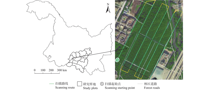
Table 1
Basic information of five kinds of plantation in the sample plots"
| 森林类型 Forest type | 林龄 Age/a | 平均树高 Average height/m | 平均胸径 Average DBH/cm | 林分密度 Stand density/(tree·hm?2) | 蓄积量 Volume/(m3·hm?2) |
| 白桦Betula platyphylla | 61 | 19.1 | 18.1 | 986 | 82.9 |
| 蒙古栎Quercus mongolica | 60 | 14.7 | 17.2 | 2 690 | 181.0 |
| 兴安落叶松Larix gmelinii | 62 | 18.0 | 19.8 | 1 120 | 160.8 |
| 樟子松Pinus sylvestris var. mongolica | 64 | 17.8 | 22.1 | 1 140 | 195.6 |
| 黑皮油松Pinus tabuliformis | 69 | 17.6 | 20.6 | 954 | 146.2 |
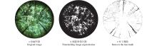
Fig.2
Image binarization"
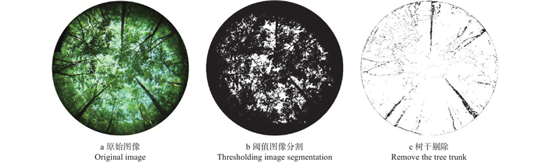
Table 2
Measured value of canopy closure of each quadrate"
| 样方编号 Sample plot No. | 1 | 2 | 3 | 4 | 5 | 6 | 7 | 8 | 9 | 10 |
| 针叶林 Coniferous forest | 0.86 | 0.86 | 0.84 | 0.84 | 0.86 | 0.86 | 0.86 | 0.86 | 0.84 | 0.86 |
| 阔叶林 Broad-leaved forest | 0.84 | 0.84 | 0.86 | 0.84 | 0.84 | 0.85 | 0.85 | 0.85 | 0.84 | 0.84 |
| 样方编号 Sample plot No. | 11 | 12 | 13 | 14 | 15 | 16 | 17 | 18 | 19 | 20 |
| 针叶林 Coniferous forest | 0.84 | 0.84 | 0.86 | 0.84 | 0.84 | 0.85 | 0.85 | 0.85 | 0.84 | 0.84 |
| 阔叶林 Broad-leaved forest | 0.83 | 0.83 | 0.83 | 0.84 | 0.84 | 0.82 | 0.81 | 0.83 | 0.84 | 0.84 |
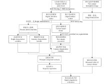
Fig.3
Technical flow chart"
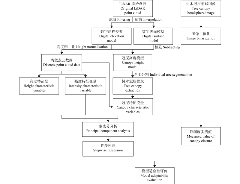
Fig.4
Canopy volume model"
Table 3
LiDAR characteristic variables and descriptions"
| 特征变量 Characteristic variable | 变量描述 Variable description |
| elev_asd | 归一化点云平均绝对偏差:总差异与给定点之间的总差值 Mean absolute deviation of normalized point cloud:the difference between the total difference and given points |
| elev_AIH_25th | 归一化点云累计高程百分数的25分位数 The 25th quantile of normalized point cloud cumulative elevation percentage |
| elev_aihInterDis | 归一化累计高程四分位数间距 Normalized cumulative elevation interquartile spacing |
| elev_cv | 首次回波归一化点云变异系数 Coefficient of variation of first echo normalized point cloud |
| elev_interDis | 归一化四分位数间距 Normalized interquartile spacing |
| elev_mad | 归一化绝对偏差中值 Median value of normalized absolute deviation |
| elev_mean | 归一化平均值 Normalized mean |
| elev_median | 归一化中值 Normalized median |
| elev_std | 归一化标准差 Normalized standard deviation |
| elev_crr | 归一化冠层起伏比率 Normalized canopy fluctuation ratio |
| int_asd | 首次回波平均绝对偏差 Mean absolute deviation of first echo |
| int_cv | 首次回波归一化点云强度的变异系数 Variation coefficient of normalized point cloud intensity of first echo |
| int_interDis | 首次回波四分位数间距 Interquartile interval of first echo |
| int_mad | 首次回波绝对偏差中值 Median absolute deviation of first echo |
| int_mean | 首次回波平均值 Mean of first echo |
| int_median | 首次回波中值 Median of first echo |
| int_std | 首次回波标准差 Standard deviation of first echo |
| int_percentile_25th | 首次回波强度百分数 First echo intensity percentage |
| int_AII_25th | 首次回波累计强度百分数 Cumulative intensity percentage of first echo |
| int_Skewness/kurtosis | 首次回波所有激光雷达点强度分布的偏度/峭度 Skewness/kurtosis of intensity distribution of all LiDAR points in the first echo |
| Open/closed | 在冠层容积模型中无体元区域的上层/下层 In the canopy volume model, the upper/lower layer of the region without voxel of free region |
| Euphotic/oligophotic | 在冠层容积模型中有体元区域的上65%区域和下35%区域的比值 The ratio of upper 65% and lower 35% of voxel regions in the canopy volume model |
| elev_density_30th、elev_density_60th | 冠层密度参数 Canopy closure parameters |
| Hskewness/Hkurtosis | 冠层首次回波的偏度/峭度 Skewness/kurtosis of canopy first echo point |
| CC2m | 首次回波中高于2 m的激光返回点占所有返回点的比例 The first return points above 2 m accounts for the percentage of all return points |
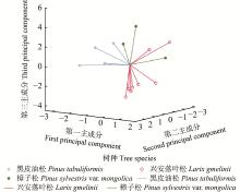
Fig.5
Principal component score of height characteristic variables for coniferous forests"
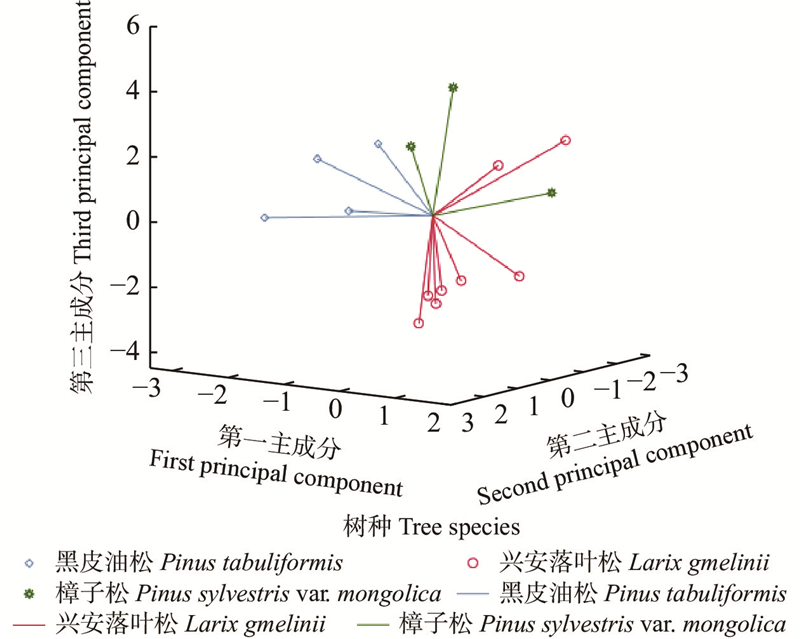
Table 4
Accuracy of regression equation"
| 植被类型 Vegetation types | 精度指标 Precision index | ||||
| R2 | Adj R2 | RMSE | rRMSE(%) | P | |
| 针叶林 Coniferous forest | 0.782 | 0.722 | 0.007 | 0.83 | 0.000 6 |
| 阔叶林 Broad-leaved forest | 0.784 | 0.725 | 0.005 | 0.59 | 0.000 6 |
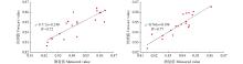
Fig.6
Cross validation results of forest canopy closure prediction model"
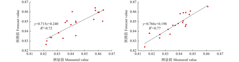

Fig.7
Measurement and estimation of forest canopy closure The red dots represent the known points of canopy closure for modeling. The 10 white points to be verified are evenly distributed in 6 rectangular plots with ground measured canopy closure data. The canopy closure points predicted by the regression equations are expressed as white triangles."
| 范伟伟, 刘浩然, 徐永胜, 等. 基于地基激光雷达和手持式移动激光雷达的单木结构参数提取精度对比. 中南林业科技大学学报, 2020, 40 (8): 63- 74. | |
| Fan W W, Liu H R, Xu Y S, et al. Comparison of extraction precision of individual tree structure parameters based on terrestrial laser scanning and hand-held mobile laser scanning. Journal of Central South University of Forestry & Technology, 2020, 40 (8): 63- 74. | |
| 谷金英, 冯仲科, 葛忠强, 等. 基于TM影像数据的林分冠层郁闭度反演技术研究. 山东林业科技, 2014, 44 (1): 9- 12. | |
| Gu J Y, Feng Z K, Ge Z Q, et al. Study on the inversion technology of forest canopy closure based on TM image data. Journal of Shandong Forestry Science and Technology, 2014, 44 (1): 9- 12. | |
| 洪奕丰, 张守攻, 陈 伟, 等. 基于机载激光雷达的落叶松组分生物量反演. 林业科学研究, 2019, 32 (5): 83- 90. | |
| Hong Y F, Zhang S G, Chen W, et al. Inversion of biomass components for Larix olgensis plantation using airborne LiDAR . Forest Research, 2019, 32 (5): 83- 90. | |
| 李 丹. 2012. 基于地基扫描与机载成像激光雷达的森林参数反演研究. 昆明: 西南林业大学. | |
| Li D. 2012. Forest parameters estimation using TLS and airborne imaging LiDAR. Kunming: Southwest Forestry University.[in Chinese] | |
| 李 擎, 王振锡, 王雅佩, 等. 基于GF-2号遥感影像的天山云杉林郁闭度估测研究. 中南林业科技大学学报, 2019, 39 (8): 48- 54. | |
| Li Q, Wang Z X, Wang Y P, et al. Study on canopy density inversion of Picea schrenkianaforest based on GF-2 remote sensing image . Journal of Central South University of Forestry & Technology, 2019, 39 (8): 48- 54. | |
| 刘 浩, 张峥男, 曹 林. 机载激光雷达森林垂直结构剖面参数的沿海平原人工林林分特征反演. 遥感学报, 2018, 22 (5): 872- 888. | |
| Liu H, Zhang Z N, Cao L. Estimating forest stand characteristics in a coastal plain forest plantation based on vertical structure profile parameters derived from ALS data. Journal of Remote Sensing, 2018, 22 (5): 872- 888. | |
| 刘浩然, 范伟伟, 徐永胜, 等. 基于无人机激光雷达点云的单木生物量估测. 中南林业科技大学学报, 2021, 41 (8): 92- 99. | |
| Liu H R, Fan W W, Xu Y S, et al. Single tree biomass estimation based on UAV LiDAR point cloud. Journal of Central South University of Forestry & Technology, 2021, 41 (8): 92- 99. | |
|
穆喜云, 张秋良, 刘清旺, 等. 基于机载LiDAR数据的林分平均高及郁闭度反演. 东北林业大学学报, 2015, 43 (9): 84- 89.
doi: 10.3969/j.issn.1000-5382.2015.09.017 |
|
|
Mu X Y, Zhang Q L, Liu Q W, et al. Inversion of forest height and canopy closure using airborne LiDAR data. Journal of Northeast Forestry University, 2015, 43 (9): 84- 89.
doi: 10.3969/j.issn.1000-5382.2015.09.017 |
|
| 瞿 帅, 张晓丽, 朱程浩, 等. 机载激光雷达森林资源调查系统的设计与试验. 西北林学院学报, 2018, 33 (4): 175- 182. | |
| Qu S, Zhang X L, Zhu C H, et al. Design and test of airborne LiDAR system for forest resources survey. Journal of Northwest Forestry University, 2018, 33 (4): 175- 182. | |
| 孙 钊, 潘 磊, 孙玉军. 基于无人机影像的高郁闭度杉木纯林树冠参数提取. 北京林业大学学报, 2020, 42 (10): 20- 26. | |
| Sun Z, Pan L, Sun Y J. Extraction of tree crown parameters from high-density pure Chinese fir plantations based on UAV images. Journal of Beijing Forestry University, 2020, 42 (10): 20- 26. | |
| 王 娟, 陈永富, 陈 巧, 等. 基于无人机遥感的森林参数信息提取研究进展. 林业资源管理, 2020, (5): 144- 151. | |
| Wang J, Chen Y F, Chen Q, et al. Research on forest parameter information extraction progress driven by UAV remote sensing technology. Forest Resources Management, 2020, (5): 144- 151. | |
| 汪 霖, 李明阳, 方子涵, 等. 基于无人机数据的人工林森林参数估测. 林业资源管理, 2019, (5): 61- 67. | |
| Wang L, Li M Y, Fang Z H, et al. Plantation forest parameter estimation based on UAV data. Forest Resources Management, 2019, (5): 61- 67. | |
| 吴项乾, 曹 林, 申 鑫, 等. 基于无人机激光雷达的银杏人工林有效叶面积指数估测. 林业科学, 2020, 56 (1): 74- 86. | |
| Wu X Q, Cao L, Shen X, et al. Estimation of effective leaf area index using UAV-based LiDAR in Ginkgo plantations . Scientia Silvae Sinicae, 2020, 56 (1): 74- 86. | |
| 吴项乾. 2018. 基于无人机激光雷达的银杏人工林有效叶面积指数及郁闭度估测研究. 南京: 南京林业大学. | |
| Wu X Q. 2018. The estimation of effective leaf area index and canopy closure using UAV-based LiDAR in ginkgo plantations abstract. Nanjing: Nanjing Forestry University.[in Chinese] | |
| 吴 飏, 张登荣, 张汉奎, 等. 结合图像纹理特征的森林郁闭度遥感估测. 林业科学, 2012, 48 (2): 48- 53. | |
| Wu Y, Zhang D R, Zhang H K, et al. Remote sensing estimation of forest canopy density combined with texture features. Scientia Silvae Sinicae, 2012, 48 (2): 48- 53. | |
|
银彬吾, 刘奇林, 陆滟灵, 等. 2种更新方式4年生尾巨桉人工林碳储量及其分布特征. 广西林业科学, 2019, 48 (4): 466- 471.
doi: 10.3969/j.issn.1006-1126.2019.04.008 |
|
|
Yin B W, Liu Q L, Lu Y L, et al. Carbon storage and distribution of 4-year-old Eucalyptus urophylla × E. grandis plantation in two regeneration modes . Guangxi Forestry Science, 2019, 48 (4): 466- 471.
doi: 10.3969/j.issn.1006-1126.2019.04.008 |
|
| 尤号田, 戚大伟, 邢艳秋. 基于机载LiDAR数据森林关键结构参数估测研究. 测绘学报, 2020, 49 (12): 1644. | |
| You H T, Qi D W, Xing Y Q. Research on forest key structural parameters estimation based on airborne LiDAR data. Acta Geodaetica et Cartographica Sinica, 2020, 49 (12): 1644. | |
| 艾萨迪拉·玉苏甫, 玉米提·哈力克, 阿不都拉·阿不力孜, 等. 基于地面LiDAR数据的塔里木河下游胡杨林结构参数反演. 生态学报, 2020, 40 (13): 4555- 4565. | |
| Yusup A, Halik Ü, Abliz A, et al. Terrestrial laser scanning for retrieving the structural parameters of Populus euphratica riparian forests in the lower reaches of the Tarim River, China . Acta Ecologica Sinica, 2020, 40 (13): 4555- 4565. | |
|
张瑞英, 庞 勇, 李增元, 等. 结合机载LiDAR和LANDSAT ETM+数据的温带森林郁闭度估测. 植物生态学报, 2016, 40 (2): 102- 115.
doi: 10.17521/cjpe.2014.0366 |
|
|
Zhang R Y, Pang Y, Li Z Y, et al. Canopy closure estimation in a temperate forest using airborne LiDAR and LANDSAT ETM+ data. Chinese Journal of Plant Ecology, 2016, 40 (2): 102- 115.
doi: 10.17521/cjpe.2014.0366 |
|
| 赵 勋, 岳彩荣, 李春干, 等. 基于机载LiDAR点云数据森林郁闭度估测. 遥感技术与应用, 2020, 35 (5): 1136- 1145. | |
| Zhao X, Yue C R, Li C G, et al. Estimation of forest canopy density based on airborne LiDAR point cloud data. Remote Sensing Technology and Application, 2020, 35 (5): 1136- 1145. | |
|
Aicardi I, Dabove P, Lingua A M, et al. Integration between TLS and UAV photogrammetry techniques for forestry applications. iForest - Biogeosciences and Forestry, 2017, 10 (1): 41- 47.
doi: 10.3832/ifor1780-009 |
|
|
Arumäe T, Lang M. Estimation of canopy cover in dense mixed-species forests using airborne lidar data. European Journal of Remote Sensing, 2018, 51 (1): 132- 141.
doi: 10.1080/22797254.2017.1411169 |
|
| Davies A B, Asner G P. Advances in animal ecology from 3D-LiDAR ecosystem mapping. Trends in Ecology & Evolution, 2014, 29 (12): 681- 691. | |
|
García M, Popescu S, Riaño D, et al. Characterization of canopy fuels using ICESat/GLAS data. Remote Sensing of Environment, 2012, 123, 81- 89.
doi: 10.1016/j.rse.2012.03.018 |
|
|
Lefsky M A, Cohen W B, Parker G G, et al. Lidar remote sensing for ecosystem studies. BioScience, 2002, 52 (1): 19- 30.
doi: 10.1641/0006-3568(2002)052[0019:LRSFES]2.0.CO;2 |
|
|
Salamí E, Barrado C, Pastor E. UAV flight experiments applied to the remote sensing of vegetated areas. Remote Sensing, 2014, 6 (11): 11051- 11081.
doi: 10.3390/rs61111051 |
|
|
Vose J M, Clinton B D, Sullivan N H, et al. Vertical leaf area distribution, light transmittance, and application of the Beer-Lambert Law in four mature hardwood stands in the southern Appalachians. Canadian Journal of Forest Research, 1995, 25 (6): 1036- 1043.
doi: 10.1139/x95-113 |
| Viewed | ||||||
|
Full text |
|
|||||
|
Abstract |
|
|||||