
Scientia Silvae Sinicae ›› 2025, Vol. 61 ›› Issue (8): 129-141.doi: 10.11707/j.1001-7488.LYKX20240390
• Research papers • Previous Articles Next Articles
Yujiao Zhang1,Hengqian Zhao1,2,*( ),Hancong Fu1,Ge Liu1,Xiadan Huangfu1,Xuanqi Liu1
Received:2024-06-24
Online:2025-08-25
Published:2025-09-02
Contact:
Hengqian Zhao
E-mail:zhaohq@cumtb.edu.cn
CLC Number:
Yujiao Zhang,Hengqian Zhao,Hancong Fu,Ge Liu,Xiadan Huangfu,Xuanqi Liu. Inversion Model of Aboveground Biomass at Individual Tree Scale Based on the Multiple Features of UAV Remote Sensing[J]. Scientia Silvae Sinicae, 2025, 61(8): 129-141.
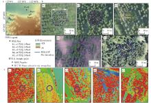
Fig.1
Location of sample plots and distribution of sample points a: Geographic location of the sample plots; b1?b5: DOM images corresponding to the sample plots; c1?c5: Normalized point cloud data corresponding to the sample plots (displayed by elevation)."

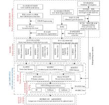
Fig.2
Flowchart of inversion model construction of the aboveground biomass at individual tree scale"
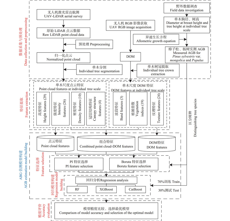
Table 1
Summary of the sample plots in the study area"
| 样地编号 Plot code | 树种 Tree species | 株数 Plant number | 平均胸径 Mean DBH/cm | 平均树高 Mean height/m |
| 1 | 樟子松 Pinus sylvestris var. mongolica | 33 | 22.6 | 9.4 |
| 2 | 樟子松 Pinus sylvestris var. mongolica | 76 | 16.8 | 9.4 |
| 3 | 杨树 Populus | 24 | 21.1 | 13.9 |
| 4 | 杨树 Populus | 36 | 24.2 | 14.1 |
| 5 | 樟子松 Pinus sylvestris var. mongolica | 41 | 17.5 | 7.5 |
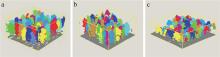
Fig.3
The results of individual tree segmentation by the point cloud-based cluster segmentation algorithm a: Populus forest with low canopy density; b: Populus forest with medium canopy density; c: Pinus sylvestris var. mongolica forest with high canopy density."
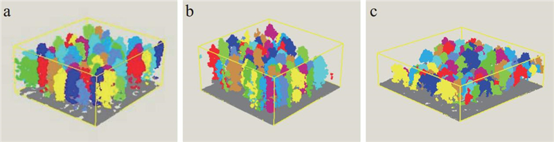
Table 2
Features extracted from point cloud data based on UAV-LiDAR"
| 特征 类型 Feature type | 特征缩写 Feature abbreviation | 描述 Description | 特征 类型 Feature type | 特征缩写 Feature abbreviation | 描述 Description | |
| 点云 高度 特征 Point cloud height feature | H_P01-95th | 点云高度百分位数Height percentiles | 点云 强度 特征 Point cloud intensity feature | I_P01-95th | 点云强度百分位数Intensity percentiles | |
| H_CRR | 冠层起伏率Canopy relief rate | I_IQ | 点云强度百分位数四分位数间距Intensity percentile interquartile range | |||
| H_IQ | 点云高度百分位数四分位数间距 Height percentile interquartile range | I_AAD | 点云强度平均绝对偏差Mean absolute deviation | |||
| H_CV | 点云高度变异系数Variable coefficient | I_CV | 点云强度变异系数Variable coefficient | |||
| H_KURT | 点云高度峰度Kurtosis | I_KURT | 点云强度峰度Kurtosis | |||
| H_SKE | 点云高度偏斜度Skewness | I_SKE | 点云强度偏斜度Skewness | |||
| H_MAX | 点云高度最大值Max. | I_MAX | 点云强度最大值Max. | |||
| H_MIN | 点云高度最小值Min. | I_MIN | 点云强度最小值Min. | |||
| H_MEAN | 点云高度平均值Mean | I_MEAN | 点云强度平均值Mean | |||
| H_ MEDIAN | 点云高度中位数Median | I_ MEDIAN | 点云强度中位数Median | |||
| H_STD | 点云高度标准差Standard deviation | I_STD | 点云强度标准差 Standard deviation | |||
| H_V | 点云高度方差Variance | I_V | 点云强度方差Variance | |||
| H_MAD | 点云高度中位数绝对偏差 Median absolute deviation | I_MAD | 点云强度中位数绝对偏差Median absolute deviation | |||
| H_SQRT | 点云高度2次幂平均2nd power average | 点云冠层 结构特征 Canopy structure feature of point cloud | TH | 树高Tree height | ||
| H_CURT | 点云高度3次幂平均3nd power average | CD | 冠径Canopy diameter | |||
| H_AIH_IQ | 点云累积高度百分位数四分位数间距 Interquartile range of accumulate height percentile | |||||
| 点云密 度特征 Point cloud density feature | D_1-10 | 将点云数据从低到高分成10个相同高度的切片,每层回波数的比例就是相应的密度特征Divide the point cloud data into 10 slices of the same height from low to high, and the proportion of echoes in each layer is the corresponding density feature | CA | 树冠面积Canopy area | ||
| CV | 树冠体积Canopy volume |
Table 3
Range of hyperparameter tuning for the three machine learning regression models used in this study"
| 模型 Model | 缩写 Abbreviations | 超参数 Hyperparameter | 数值范围 Range of values |
| 随机森林 Random forest | RF | n_estimators max_depth min_samples_split | [50, 300, 10] [3,10,1] [2, 10, 1] |
| 极端梯度提升树 Extreme gradient boosting | XGBoost | learning_rate max_depth min_child_weight | [0.01, 0.1, 0.01] [2,10,1] [1,10,1] |
| 分类提升算法 Categorical features gradient boosting | CatBoost | iterations learning_rate depth | [20,300, 10] [0.01,0.2,0.01] [2,10,1] |
Table 4
Accuracy analysis of individual tree segmentation"
| 样地编号 Plot code | 正确分割数量 Number of correct segments/plant | 欠分割数量 Number of under segments/plant | 过分割数量 Number of false segments/plant | 召回率 Recall(r) | 准确率 Precision(p) | 调和值 F-score(F) |
| 1 | 21 | 6 | 6 | 0.78 | 0.78 | 0.78 |
| 2 | 38 | 29 | 8 | 0.57 | 0.82 | 0.67 |
| 3 | 24 | 0 | 0 | 1 | 1 | 1 |
| 4 | 27 | 7 | 2 | 0.79 | 0.93 | 0.85 |
| 5 | 25 | 7 | 9 | 0.78 | 0.73 | 0.75 |
Fig.4
The results of the individual tree segmentation for plot 4 a: the results of the individual tree crown boundary extracted based on DOM data; b: the results of the individual tree crown segmentation based on point cloud; c: the matching results of canopy after individual tree segmentation based on point cloud; d: the post-processing results of not-matched canopy after individual tree segmentation based on point cloud."
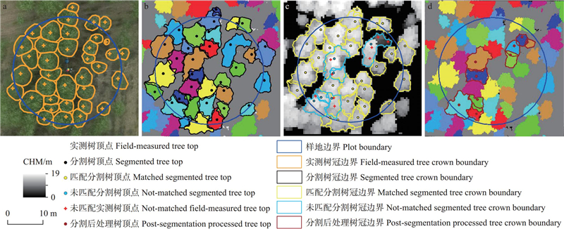
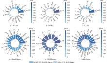
Fig.5
The results of feature selection for Pinus sylvestris var. mongolica PIM: permutation importance mean; FISM: feature importance score mean. a, b, and c represent the feature selection results using the PI method for LiDAR, DOM, and ALL, respectively; d, e, and f represent the feature selection results using the Boruta method for LiDAR, DOM, and ALL, respectively."
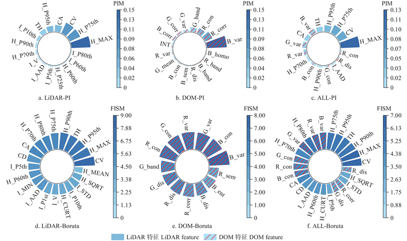
Fig.6
The results of feature selection for Populus PIM: permutation importance mean;FISM: feature importance score mean. a, b, and c represent the feature selection results using the PI method for LiDAR, DOM, and ALL, respectively; d, e, and f represent the feature selection results using the Boruta method for LiDAR, DOM, and ALL, respectively."
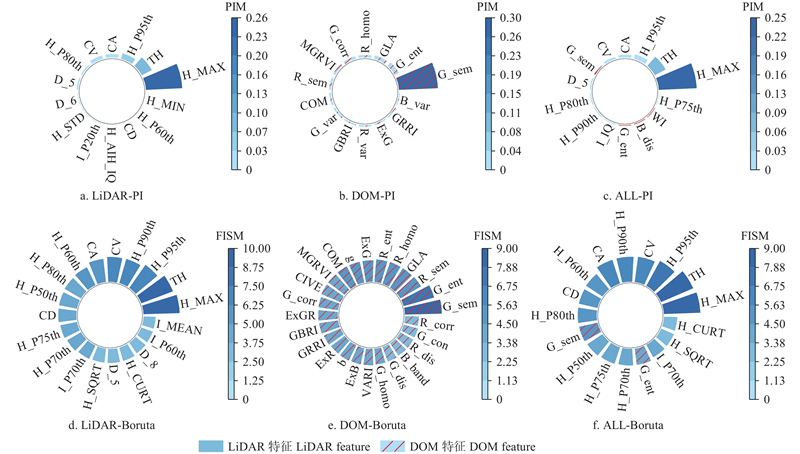
Table 5
The statistics of the accuracy of various modeling algorithms based on different datasets RMSE kg·plant?1"
| 树种 Tree species | 模型 Model | 数据Data | ||||||||||||||||
| LiDAR | DOM | ALL(LiDAR+DOM) | ||||||||||||||||
| 训练集 Training set | 测试集 Test set | 训练集 Training set | 测试集 Test set | 训练集 Training set | 测试集 Test set | |||||||||||||
| R2 | RMSE | R2 | RMSE | R2 | RMSE | R2 | RMSE | R2 | RMSE | R2 | RMSE | |||||||
| 樟子松 Pinus sylvestris var. mongolica | PI- RF | 0.94 | 6.25 | 0.67 | 13.24 | 0.77 | 12.17 | 0.67** | 13.16 | 0.90 | 7.97 | 0.76 | 11.09 | |||||
| Boruta-RF | 0.91 | 7.42 | 0.68 | 12.91 | 0.74 | 12.90 | 0.66 | 13.21 | 0.91 | 7.63 | 0.76 | 11.27 | ||||||
| PI-CatBoost | 0.81 | 11.21 | 0.63 | 13.99 | 0.86 | 9.49 | 0.64 | 13.61 | 0.90 | 7.74 | 0.69 | 12.80 | ||||||
| Boruta-CatBoost | 0.83 | 10.55 | 0.68 | 12.92 | 0.87 | 9.01 | 0.60 | 14.53 | 0.86 | 9.47 | 0.69 | 12.74 | ||||||
| PI-XGBoost | 0.99* | 2.62 | 0.69* | 12.75 | 0.99** | 1.27 | 0.44 | 17.13 | 0.95 | 5.58 | 0.77*** | 10.94 | ||||||
| Boruta-XGBoost | 0.96 | 4.97 | 0.63 | 13.88 | 0.93 | 6.41 | 0.52 | 15.84 | 0.95*** | 5.44 | 0.72 | 12.29 | ||||||
| 杨树 Populus | PI- RF | 0.95 | 8.31 | 0.83 | 18.81 | 0.94 | 8.94 | 0.52 | 31.15 | 0.94 | 8.99 | 0.82 | 19.18 | |||||
| Boruta-RF | 0.89 | 12.26 | 0.81 | 19.64 | 0.93 | 9.85 | 0.54 | 30.65 | 0.88 | 12.62 | 0.82 | 18.90 | ||||||
| PI-CatBoost | 0.94 | 8.83 | 0.80 | 19.85 | 0.99 | 3.42 | 0.48 | 32.60 | 0.99 | 2.04 | 0.84 | 17.81 | ||||||
| Boruta-CatBoost | 0.95* | 8.16 | 0.75 | 22.37 | 0.99** | 0.47 | 0.59** | 28.99 | 0.99*** | 0.01 | 0.64 | 26.99 | ||||||
| PI-XGBoost | 0.94 | 8.55 | 0.81 | 19.58 | 0.99 | 3.24 | 0.55 | 30.16 | 0.97 | 5.78 | 0.85*** | 17.63 | ||||||
| Boruta-XGBoost | 0.94 | 8.40 | 0.85* | 17.11 | 0.98 | 4.71 | 0.54 | 30.52 | 0.91 | 10.85 | 0.82 | 19.05 | ||||||
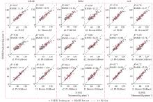
Fig.7
Scatter plot of AGB for feature optimization treatments of three datasets and three regression model inversions(Pinus sylvestris var. mongolica)"
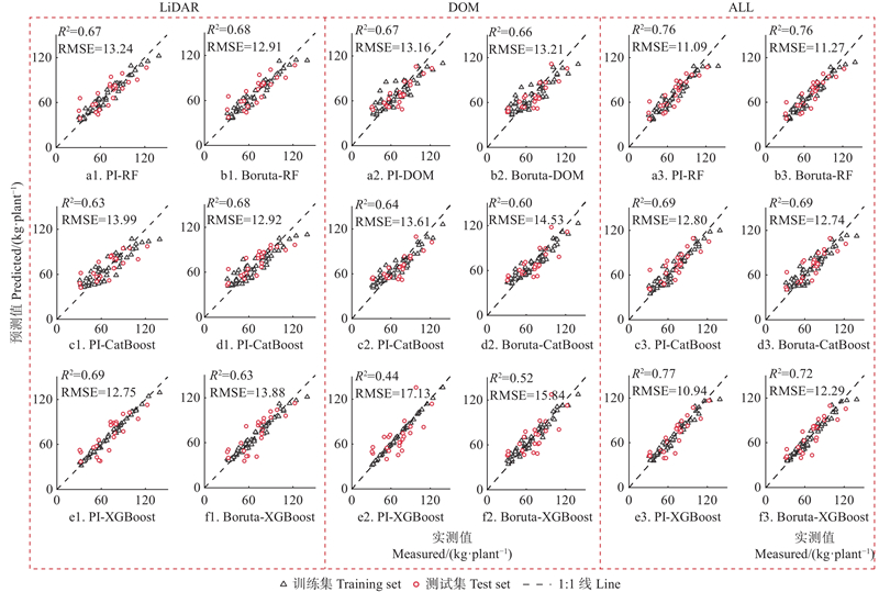
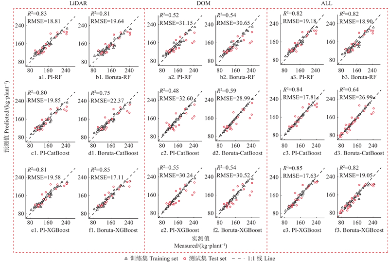
Fig.8
Scatter plot of AGB for feature optimization treatments of three datasets and three regression model inversions(Populus)"
|
包栎炀, 王祥军, 李少达, 等. 基于无人机LiDAR的橡胶树单木地上生物量估测. 热带作物学报, 2023, 44 (6): 1266- 1275.
doi: 10.3969/j.issn.1000-2561.2023.06.020 |
|
|
Bao L Y, Wang X J, Li S D, et al. Estimation of individual tree above-ground biomass of rubber tree based on UAV-LiDAR. Chinese Journal of Tropical Crops, 2023, 44 (6): 1266- 1275.
doi: 10.3969/j.issn.1000-2561.2023.06.020 |
|
| 戴莉莉, 李海涛, 顾海燕, 等. 特征优选下的遥感影像面向对象分类规则构建. 测绘科学, 2019, 44 (2): 26- 32. | |
| Dai L L, Li H T, Gu H Y, et al. Construction of object-based image classification rules for remote sensing images supported by feature optimization. Science of Surveying and Mapping, 2019, 44 (2): 26- 32. | |
|
耿 林, 李明泽, 范文义, 等. 基于机载LiDAR的单木结构参数及林分有效冠的提取. 林业科学, 2018, 54 (7): 62- 72.
doi: 10.11707/j.1001-7488.20180707 |
|
|
Geng L, Li M Z, Fan W Y, et al. Individual tree structure parameters and effective crown of the stand extraction base on airborn LiDAR data. Scientia Silvae Sinicae, 2018, 54 (7): 62- 72.
doi: 10.11707/j.1001-7488.20180707 |
|
|
黄金龙, 居为民, 郑 光, 等. 基于高分辨率遥感影像的森林地上生物量估算. 生态学报, 2013, 33 (20): 6497- 6508.
doi: 10.5846/stxb201212211841 |
|
|
Huang J L, Ju W M, Zheng G, et al. Estimation of forest aboveground biomass using high spatial resolution remote sensing imagery. Acta Ecologica Sinica, 2013, 33 (20): 6497- 6508.
doi: 10.5846/stxb201212211841 |
|
| 菅永峰, 韩泽民, 黄光体, 等. 基于高分辨率遥感影像的北亚热带森林生物量反演. 生态学报, 2021, 41 (6): 2161- 2169. | |
| Jian Y F, Han Z M, Huang G T, et al. Estimation of forest biomass using high spatial resolution remote sensing imagery in north subtropical forests. Acta Ecologica Sinica, 2021, 41 (6): 2161- 2169. | |
| 蒋馥根, 孙 华, 李成杰, 等. 联合GF-6和Sentinel-2红边波段的森林地上生物量反演. 生态学报, 2021, 41 (20): 8222- 8236. | |
| Jiang F G, Sun H, Li C J, et al. Retrieving the forest aboveground biomass by combining the red edge bands of Sentinel-2 and GF-6. Acta Ecologica Sinica, 2021, 41 (20): 8222- 8236. | |
| 李 丹. 2018. 基于数字航空摄影数据的森林参数反演估测研究. 北京: 中国科学院大学(中国科学院遥感与数字地球研究所). | |
| Li D. 2018. Retrieval and estimation research of forest parameters based on digital aerial photograph data. Beijing: University of Chinese Academy of Sciences(Institute of Remote Sensing and Digital Earth Chinese Academy of Sciences. [in Chinese ] | |
| 李 旺, 牛 铮, 王 成, 等. 机载LiDAR数据估算样地和单木尺度森林地上生物量. 遥感学报, 2015, 19 (4): 669- 679. | |
| Li W, Niu Z, Wang C, et al. Forest above-ground biomass estimation at plot and tree levels using airborne Li DAR data. Journal of Remote Sensing, 2015, 19 (4): 669- 679. | |
|
孙 钊, 谢运鸿, 王宝莹, 等. 基于无人机多维数据集的森林地上生物量估测模型研究. 农业机械学报, 2024, 55 (6): 186- 195,236.
doi: 10.6041/j.issn.1000-1298.2024.06.019 |
|
|
Sun Z, Xie Y H, Wang B Y, et al. Development of forest aboveground biomass estimation model based on multidimensional dataset of UAV. Transactions of the Chinese Society for Agricultural Machinery, 2024, 55 (6): 186- 195,236.
doi: 10.6041/j.issn.1000-1298.2024.06.019 |
|
| 王 嫚. 2023. 基于贝叶斯方法和多源遥感的落叶松人工林多尺度地上生物量估算. 哈尔滨: 东北林业大学. | |
| Wang M. 2023. The estimation of aboveground biomass of larix olgensis plantation based on Bayesian approach and multi-source remote sensing data. Harbin: Northeast Forestry University.[in Chinese] | |
| 武晓康. 2023. 基于UAV LiDAR的单木生物量反演研究. 桂林: 桂林理工大学. | |
| Wu X K. 2023. Research on individual tree biomass extraction based on UAV LiDAR. Guilin: Guilin University of Technology. [ in Chinese]. | |
|
武晓康, 王浩宇, 冯宝坤, 等. 基于无人机LiDAR的单木生物量估测. 科学技术与工程, 2022, 22 (34): 15028- 15035.
doi: 10.3969/j.issn.1671-1815.2022.34.006 |
|
|
Wu X K, Wang H Y, Feng B K, et al. Individual tree biomass estimation based on UAV airborne LiDAR. Science Technology and Engineering, 2022, 22 (34): 15028- 15035.
doi: 10.3969/j.issn.1671-1815.2022.34.006 |
|
|
徐 婷, 曹 林, 申 鑫, 等. 基于机载激光雷达与Landsat 8 OLI数据的亚热带森林生物量估算. 植物生态学报, 2015, 39 (4): 309- 321.
doi: 10.17521/cjpe.2015.0030 |
|
|
Xu T, Cao L, Shen X, et al. Estimates of subtropical forest biomass based on airborne LiDAR and Landsat 8 OLI data. Chinese Journal of Plant Ecology, 2015, 39 (4): 309- 321.
doi: 10.17521/cjpe.2015.0030 |
|
|
杨晓慧, 吴金卓, 刘浩然, 等. 基于UAV-LiDAR的人工林林分郁闭度估测. 林业科学, 2023, 59 (8): 12- 21.
doi: 10.11707/j.1001-7488.LYKX20210955 |
|
|
Yang X H, Wu J Z, Liu H R, et al. Estimation on canopy closure for plantation forests based on UAV-LiDAR. Scientia Silvae Sinicae, 2023, 59 (8): 12- 21.
doi: 10.11707/j.1001-7488.LYKX20210955 |
|
| 于海洋, 谢赛飞, 郭灵辉, 等. 融合光谱和空间特征的土壤重金属含量极端随机树估算. 农业机械学报, 2022, 53 (8): 231- 239. | |
| Yu H Y, Xie S F, Guo L H, et al. Extremely randomized trees estimation of soil heavy metal content by fusing spectra and spatial features. Transactions of the Chinese Society for Agricultural Machinery, 2022, 53 (8): 231- 239. | |
| 钟 浩. 2024. 联合无人机多源遥感数据单木生物量反演研究. 哈尔滨: 东北林业大学. | |
| Zhong H. 2024. Study on biomass inversion of single tree from multi-source remote sensing data of UAV. Harbin: Northeast Forestry University. [in Chinese]. | |
| 周 榕. 2023. 机载与地基激光点云融合及林木参数提取研究. 长沙: 中南林业科技大学. | |
| Zhou R. 2023. Study on fusion of airborne and ground-based laser point clouds and extraction of forest parameters. Changsha: Central South University of Forestry & Technology. [in Chinese]. | |
|
Dalla Corte A P, Souza D V, Rex F E, et al. Forest inventory with high-density UAV-lidar: machine learning approaches for predicting individual tree attributes. Computers and Electronics in Agriculture, 2020, 179, 105815.
doi: 10.1016/j.compag.2020.105815 |
|
|
Dalponte M, Frizzera L, Orka HO, et al. Predicting stem diameters and aboveground biomass of individual trees using remote sensing data. Ecological Indicators, 2018, 85, 367- 376.
doi: 10.1016/j.ecolind.2017.10.066 |
|
|
Jin S C, Su Y J, Gao S, et al. The transferability of random forest in canopy height estimation from multi-source remote sensing data. Remote Sensing, 2018, 10 (8): 1183.
doi: 10.3390/rs10081183 |
|
|
Juan-Ovejero R, Elghouat A, Navarro C J, et al. Estimation of aboveground biomass and carbon stocks of Quercus ilex L. saplings using UAV-derived RGB imagery. Annals of Forest Science, 2023, 80 (1): 44.
doi: 10.1186/s13595-023-01210-x |
|
|
Jucker T, Caspersen J, Chave J, et al. Allometric equations for integrating remote sensing imagery into forest monitoring programmes. Global Change Biology, 2017, 23 (1): 177- 190.
doi: 10.1111/gcb.13388 |
|
|
Liang Y Y, Kou W L, Lai H Y, et al. Improved estimation of aboveground biomass in rubber plantations by fusing spectral and textural information from UAV-based RGB imagery. Ecological Indicators, 2022, 142, 109286.
doi: 10.1016/j.ecolind.2022.109286 |
|
| Lin J Y, Chen D C, Wu W J, et al. Estimating aboveground biomass of urban forest trees with dual-source UAV acquired point clouds. Urban Forestry & Urban Greening, 2022, 69, 127521. | |
|
Liu Y, Lei P, You Q X, et al. Individual tree aboveground biomass estimation based on UAV stereo images in a Eucalyptus plantation. Forests, 2023, 14 (9): 1748.
doi: 10.3390/f14091748 |
|
|
Malek S, Miglietta F, Gobakken T, et al. Prediction of stem diameter and biomass at individual tree crown level with advanced machine learning techniques. IForest - Biogeosciences and Forestry, 2019, 12 (3): 323- 329.
doi: 10.3832/ifor2980-012 |
|
| Mao Z H, Lu Z, Wu Y J, et al. 2023. DBH estimation for individual tree: two-dimensional images or three-dimensional point clouds? Remote Sensing, 15(16): 4116. | |
|
Sun Z, Wang Y F, Ding Z D, et al. Individual tree segmentation and biomass estimation based on UAV Digital aerial photograph. Journal of Mountain Science, 2023, 20 (3): 724- 737.
doi: 10.1007/s11629-022-7563-7 |
|
|
Tian Y C, Huang H, Zhou G Q, et al. Aboveground mangrove biomass estimation in Beibu Gulf using machine learning and UAV remote sensing. Science of the Total Environment, 2021, 781, 146816.
doi: 10.1016/j.scitotenv.2021.146816 |
|
|
Xu D D, Wang H B, Xu W X, et al. LiDAR applications to estimate forest biomass at individual tree scale: opportunities, challenges and future perspectives. Forests, 2021, 12 (5): 550.
doi: 10.3390/f12050550 |
|
|
Yan M, Xia Y H, Yang X Y, et al. Biomass estimation of subtropical arboreal forest at single tree scale based on feature fusion of airborne LiDAR data and aerial images. Sustainability, 2023, 15 (2): 1676.
doi: 10.3390/su15021676 |
| [1] | Xiong Xiaoyan, Li Caixia, Chai Guoqi, Chen Long, Jia Xiang, Lei Lingting, Zhang Xiaoli. Estimation of Aboveground Biomass in Regional Forests by Using Integrating UAV-LiDAR and GEDI Data [J]. Scientia Silvae Sinicae, 2025, 61(8): 142-153. |
| [2] | Zeyu Yuan,Hang Xu,Yi Ren,Yang Xu,Jianzhuang Pang,Xiaoyun Wu,Hanyao Zhang,Zhiqiang Zhang. Distribution Characteristics of Vegetation Resilience and its Driving Factors in the Three-North Shelterbelt Forest Program Region from 2001 to 2021 [J]. Scientia Silvae Sinicae, 2025, 61(7): 182-191. |
| [3] | Feifei Yang,Wangfei Zhang,Lei Zhao,Han Zhao,Yongjie Ji,Mengjin Wang. Two-Stage Remote Sensing Feature Optimization and GF-1 Data-Supported Forest Above-Ground Biomass Inversion [J]. Scientia Silvae Sinicae, 2025, 61(4): 9-19. |
| [4] | Xiaoning Ge,Xinqiao Xu,Huaiqing Zhang,Jing Zhang,Jie Yang,Zeyu Cui,Rurao Fu,Jinjie Liang,Tianhua Zou,Linlong Wang,Yang Liu. Progress and Reflection on Genotype-Environment Interaction Algorithms in Forest Tree Breeding [J]. Scientia Silvae Sinicae, 2025, 61(3): 1-15. |
| [5] | Dan Pan,Luyi Luo,Kaiwen Ji,Fanbin Kong. Impact of Rural E-Commerce Development on Intra-Regional Income Gap and Shared Prosperity in Forested Areas [J]. Scientia Silvae Sinicae, 2024, 60(5): 35-50. |
| [6] | Chenchen Shen,Wenfa Xiao,Jianhua Zhu,Lixiong Zeng,Jizhen Chen,Zhilin Huang. Characterization of Soil Organic Carbon and Key Influencing Factors of Natural Forests in Central China Based on Machine Learning Algorithms [J]. Scientia Silvae Sinicae, 2024, 60(3): 65-77. |
| [7] | Xiaohui Yang,Jinzhuo Wu,Haoran Liu,Hao Zhong,Wenshu Lin. Estimation on Canopy Closure for Plantation Forests Based on UAV-LiDAR [J]. Scientia Silvae Sinicae, 2023, 59(8): 12-21. |
| [8] | Qiangying Jiao,Zongfu Han,Weiye Wang,Di Liu,Pengxu Pan,Bo Li,Nianci Zhang,Ping Wang,Jinhua Tao,Meng Fan. Driving Factors and Forecasting Model of Lightning-Caused Forest Fires in Daxing’ anling Mountains Based on Multi-Sources Data and Machine Learning Method [J]. Scientia Silvae Sinicae, 2023, 59(6): 74-87. |
| [9] | Nannan Yang,Yan Bai,Suyi Jiang,Chunmei Yang,Kaihong Xu. Recognition Method of Plate and Wood Based on ALexNet Optimaization [J]. Scientia Silvae Sinicae, 2022, 58(3): 149-158. |
| Viewed | ||||||
|
Full text |
|
|||||
|
Abstract |
|
|||||