
林业科学 ›› 2026, Vol. 62 ›› Issue (3): 74-87.doi: 10.11707/j.1001-7488.LYKX20250054
周晟,蒋馥根,陈帅,龙依,王彬彬,宋子戈,孙华*( )
)
收稿日期:2025-02-05
修回日期:2025-04-19
出版日期:2026-03-15
发布日期:2026-03-12
通讯作者:
孙华
E-mail:sunhua@csuft.edu.cn
基金资助:
Sheng Zhou,Fugen Jiang,Shuai Chen,Yi Long,Binbin Wang,Zige Song,Hua Sun*()
Received:2025-02-05
Revised:2025-04-19
Online:2026-03-15
Published:2026-03-12
Contact:
Hua Sun
E-mail:sunhua@csuft.edu.cn
摘要:
目的: 探索新一代冰、云和陆地高程卫星(ICESat-2)与机载激光雷达及Sentinel-2多源数据联合反演区域森林地上生物量(AGB)的适配性,为大范围森林资源管理和动态监测提供科学依据。方法: 以内蒙古赤峰市旺业甸林场为研究区,基于机载激光雷达数据和样地实测数据建立高精度AGB估测模型,将样地AGB由离散的“点”状数据扩展到连续的“面”状数据,以克服样地点与星载点之间难以匹配的问题;在此基础上,联合ICESat-2与Sentinel-2遥感数据进行AGB反演,并基于最佳特征变量组合与最优反演模型,绘制研究区森林地上生物量空间分布图。结果: 1) 基于机载激光雷达提取的三维结构信息与森林AGB高度相关,随机森林模型反演结果精度最高,相关系数为0.91,均方根误差(RMSE)为17.00 t·hm?2, 估测精度(EA)为88.90%。2) 在Sentinel-2基础上引入ICESat-2变量后,可进一步提升模型反演精度(R2=0.74, RMSE=27.44 t·hm?2, EA=69.32%),R2和EA分别提高30.26%和14.18%。3) 研究区森林AGB空间分布结果显示,东南部森林AGB分布较低(平均为97.13t·hm?2),中东部和东北部森林AGB分布较高(平均为117.03 t·hm?2),与实际分布一致。结论: 基于机载激光雷达数据反演的森林AGB精度较高,可作为连接样地实测数据和星载数据的中间参数。结合机载激光雷达、Sentinel-2及ICESat-2数据,不仅可提升森林AGB估测精度,也可为区域范围的森林资源管理和动态监测提供新的方法参考。
中图分类号:
周晟,蒋馥根,陈帅,龙依,王彬彬,宋子戈,孙华. 联合星−空激光雷达和Sentinel-2数据的森林地上生物量估测方法[J]. 林业科学, 2026, 62(3): 74-87.
Sheng Zhou,Fugen Jiang,Shuai Chen,Yi Long,Binbin Wang,Zige Song,Hua Sun. Estimation of Forest Aboveground Biomass Using Joint Spaceborne-UAV LiDAR and Sentinel-2 Data[J]. Scientia Silvae Sinicae, 2026, 62(3): 74-87.
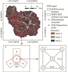
图1
研究区位置、遥感数据及样地设置示意 a:样地点、星载点和无人机区域分布;b:无人机飞行条带;c:样地设置示意,A、B、C、D表示分别样地的4个角点,E表示样地中心点。a: Distribution map of sample sites, spaceborne points and UAV areas; b: UAV flight strips; c: Schematic diagram of the sample site settings. A, B, C, D irepresent the four corner points of the sample plots, and E represents the center point of the sample plot."

表1
研究使用的机载和星载激光雷达特征变量"
| 数据类型 Data type | 变量名称 Variable name | 缩写 Abbreviation |
| 无人机激光雷达 UAV LiDAR | 密度特征变量Density metrics | den |
| 高度特征变量Elevation metrics | ele | |
| 强度特征变量Intensity metrics | int | |
| 星载激光雷达 Spaceborne LiDAR | 表观地表反射率Apparent surface reflectance | asr |
| 最小冠层高度Minimum height | h_min | |
| 平均冠层高度Mean height | h_mean | |
| 中位数冠层高度Median height | h_mid | |
| 最大冠层高度Maximum height | h_max | |
| 地形最合适高度Terrain height best fit | h_dem | |
| 冠层高度百分位数Canopy height percentile | h_p (p=25, 50, 60, 70, 75, 80, 85, 90, 95, 98) |
表2
研究使用的光谱遥感变量①"
| 变量名称 Variable name | 计算公式 Calculation formula | 变量名称 Variable name | 计算公式 Calculation formula | |
| 大气阻抗植被指数 Atmospherically resistant vegetation index (ARVI) | 绿色归一化差异植被指数 Green normalized difference vegetation index (GNDVI) | |||
| 差异植被指数 Difference vegetation index (DVI) | 绿色比值植被指数 Green ratio vegetation index (GRVI) | |||
| 增强植被指数 Enhanced vegetation index (EVI) | 归一化植被指数 Normalized difference vegetation index (NDVI) | |||
| 绿色大气阻力指数 Green atmospherically resistant index (GARI) | 红边简单比值 Red edge simple ratio (RESR) | |||
| 绿差植被指数 Green difference vegetation index (GDVI) | 红边叶绿素指数 Red edge chlorophyll index (RECI) | |||
| 红边归一化差值植被指数a Red edge normalized difference vegetation index a (RENDVI_a) | 红边归一化差值植被指数b Red edge normalized difference vegetation index b (RENDVI_b) | |||
| 单波段反射率 Original band reflectance | 灰度差分向量 Gray level difference vector (GLDV) | |||
| 灰度共生矩阵 Gray level co-occurrence matrix (GLCM) | 和差直方图 Sum and difference histogram (SADH) |
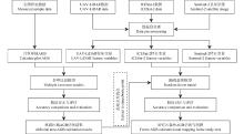
图2
数据处理与森林地上生物量估测框架"
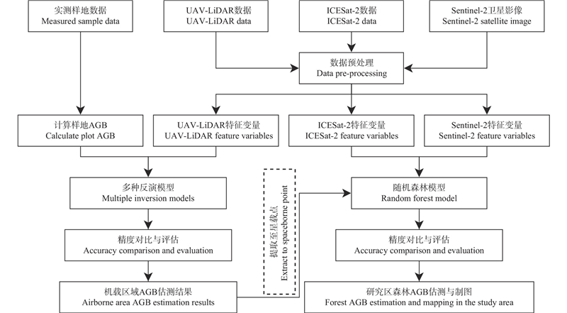
图3
机载LiDAR变量与样地AGB相关系数矩阵 ele表示高度相关变量,int表示强度相关变量,den表示密度相关变量。ele represents height-related variables, int represents intensity-related variables, and den represents density-related variables."
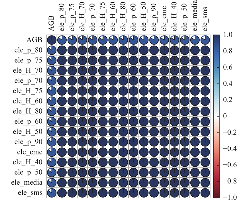
表3
逐步线性回归模型信息①"
| 参数 Parameters | 系数 Coefficient | 显著性 Significance |
| 常数Constant | –30.49 | 0.03 |
| ele_p_80 | 8.88 | 0 |
| ele_kurto | –8.94 | 0 |
| ele_crr | 134.37 | 0.01 |
图4
基于不同反演模型的AGB拟合结果"
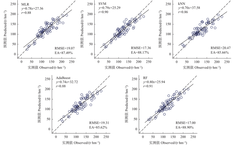
表4
不同变量组合的随机森林模型精度验证结果①"
| 数据源 Data source | 组合 Combination | 变量 Variables | 决定 系数 R2 | 均方根 误差 RMSE/ ( t?hm?2) | 相对均方 根误差 rRMSE (%) | 估测精度 EA (%) |
| Sentinel-2 | 变量组合1 Combination 1 | b2, EVI, b3, GDVI, b4 | 0.44 | 35.21 | 36.88 | 59.26 |
| 变量组合2 Combination 2 | b2, GLCM_3_ent, b3, GLCM_2_sec, GLCM_3_sec, GLCM_2_ent, GLCM_7_var, GLCM_5_ent, GLCM_1_var, GLCM_7_con | 0.53 | 34.37 | 35.99 | 59.20 | |
| 变量组合3 Combination 3 | b2, GLDV_8_sec, b3, GLDV_5_ent, GLDV_2_var, GLDV_2_ent, GLDV_4_ent, GLDV_2_mea, GLDV_7_var, GLDV_2_con, GLDV_4_sec | 0.51 | 33.74 | 35.33 | 61.46 | |
| 变量组合4 Combination 4 | b2, SADH_8_cor, SADH_1_sec, b3, SADH_6_var, SADH_7_con, SADH_3_sec, SADH_2_sec, SADH_4_cor, SADH_7_var, SADH_7_hom, SADH_4_mea | 0.54 | 33.46 | 35.04 | 60.78 | |
| 变量组合5 Combination 5 | b2, GLDV_8_var, GLCM_4_mea, GLDV_8_ent, GLCM_7_dis, b3, GLCM_2_ent, GLDV_8_sec, GLDV_2_var | 0.56 | 33.02 | 34.58 | 60.71 | |
| Sentinel-2+ ICESat-2 | 变量组合6 Combination 6 | h_85, NDVI, h_max, GLCM_3_ent, h_dem, GLCM_3_cor, GLCM_6_ent, GLDV_1_ent, h_70, h_mean, RENDVI_a, ARVI, GLCM_1_cor | 0.74 | 27.44 | 28.74 | 69.32 |
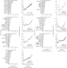
图5
变量重要性排序和RMSE变化 ARVI:大气阻抗植被指数 Atmospherically resistant vegetation index;DVI:差值植被指数 Difference vegetation index;EVI:增强植被指数 Enhanced vegetation index;GARI:绿色大气阻力指数 Green atmospherically resistant index;GDVI:绿差植被指数 Green difference vegetation index;GNDVI:绿色归一化差异植被指数 Green normalized difference vegetation index;RECI:红边叶绿素指数 Red edge chlorophyll index;RENDVI_a:红边归一化差值植被指数a Red edge normalized difference vegetation index a;RENDVI_b:红边归一化差值植被指数b Red edge normalized difference vegetation index b;RESR:红边简单比值 Red edge simple ratio;$ B_i=\mathrm{Band}_i,\ i= $1、2、…、8:单波段反射率 Single band reflectivity;$ \text{GLCM}\_ i\_ j $:灰度共生矩阵 Gray level co-occurrence matrix;$ \mathrm{G}\text{LDV}\_ i\_ j $:灰度差分向量 Gray level difference vector;$ \text{SADH}\_ i\_ j $:和差直方图 Sum and difference histogram;RMSE:均方根误差 Root mean square error."
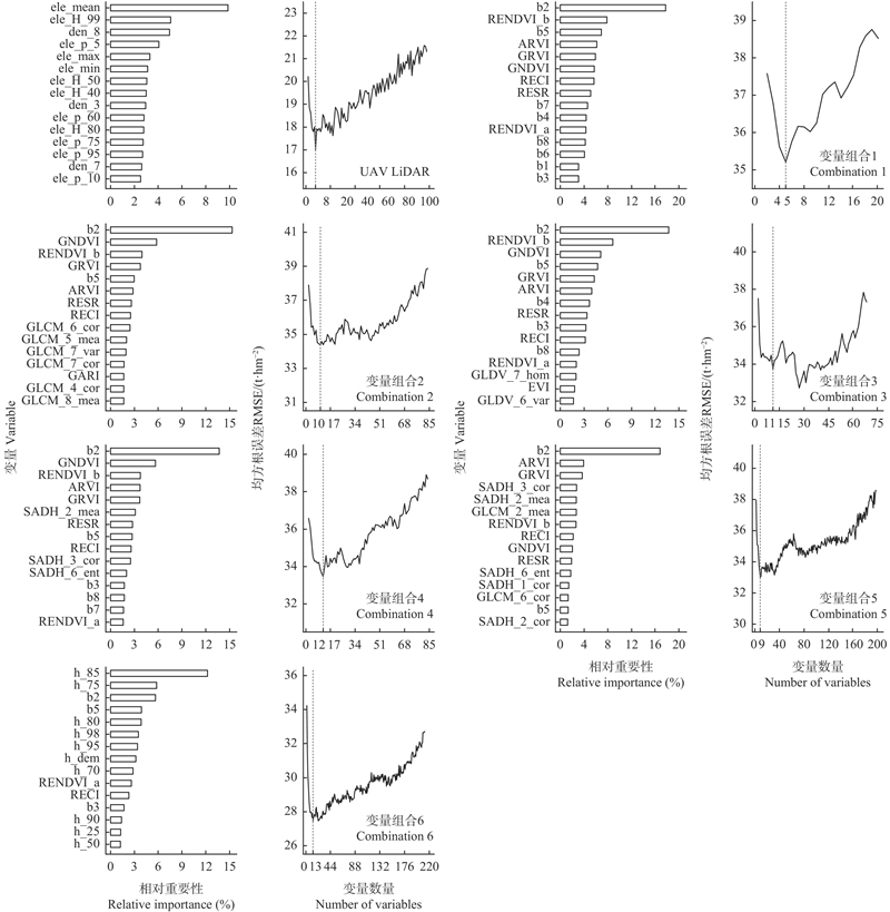
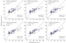
图6
基于不同变量组合的森林AGB拟合结果"
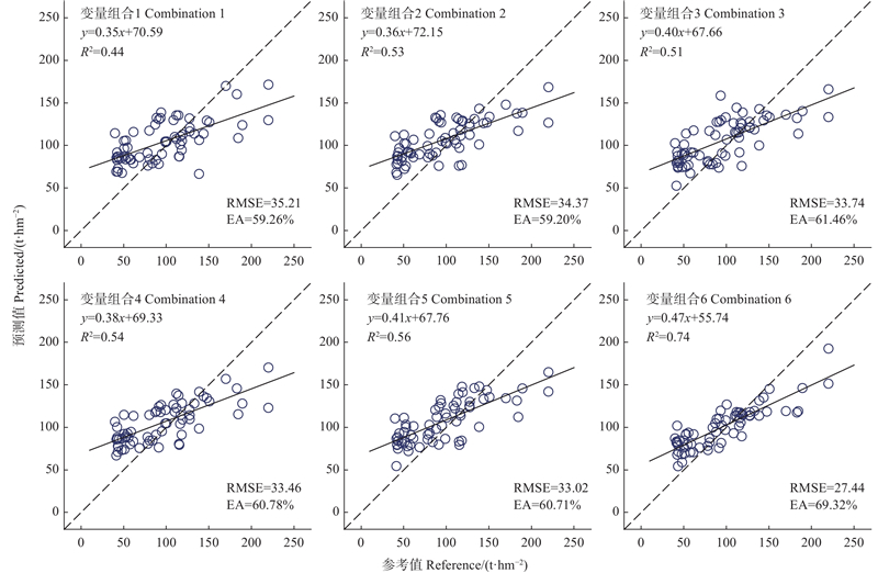
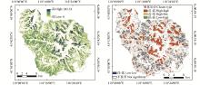
图7
研究区森林AGB空间分布(a)和聚集分布(b)"
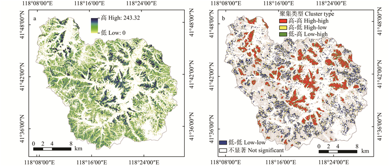
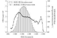
图8
研究区森林生物量与海拔的关系"

图9
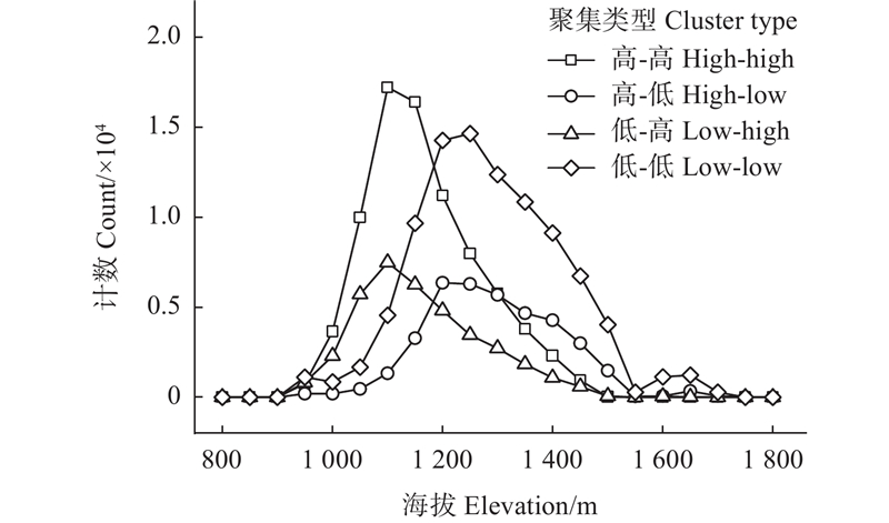
研究区聚集类型与海拔的关系"
|
曹海翊, 邱心怡, 贺 涛. 森林生物量遥感卫星发展综述. 光学学报, 2022, 42 (17): 402- 409.
doi: 10.3788/AOS202242.1728001 |
|
|
Cao H Y, Qiu X Y, He T. Review on development of forest biomass remote sensing satellites. Acta Optica Sinica, 2022, 42 (17): 402- 409.
doi: 10.3788/AOS202242.1728001 |
|
|
杜 洁, 史 硕, 刘晨曦. 基于ICESat-2光斑尺度外推建模的不同森林类型地上生物量反演. 测绘通报, 2024, 62 (10): 32- 38.
doi: 10.13474/j.cnki.11-2246.2024.1006 |
|
|
Du J, Shi S, Liu C X. Extrapolation modeling of aboveground biomass for different forest types based on ICESat-2 footprint scale. Bulletin of Surveying and Mapping, 2024, 62 (10): 32- 38.
doi: 10.13474/j.cnki.11-2246.2024.1006 |
|
|
何钊全, 尚 雪, 张铜会, 等. 近20年陕北黄土丘陵区景观生态风险时空变化及其冷热点格局. 生态学杂志, 2023, 42 (10): 2514- 2525.
doi: 10.13292/j.1000-4890.202310.007 |
|
|
He Z Q, Shang X, Zhang T H, et al. Spatiotemporal variations of landscape ecological risk and its cold-hot spot pattern in the loess hills of northern Shaanxi over the past 20 years. Chinese Journal of Ecology, 2023, 42 (10): 2514- 2525.
doi: 10.13292/j.1000-4890.202310.007 |
|
|
姬永杰, 张王菲. 森林地上生物量合成孔径雷达技术反演研究综述. 世界林业研究, 2022, 35 (3): 32- 39.
doi: 10.13348/j.cnki.sjlyyj.2021.0113.y |
|
|
Ji Y J, Zhang W F. Research on retrieval of forest aboveground biomass by SAR technology. World Forestry Research, 2022, 35 (3): 32- 39.
doi: 10.13348/j.cnki.sjlyyj.2021.0113.y |
|
| 蒋馥根, 孙 华, 李成杰, 等. 联合GF-6和Sentinel-2红边波段的森林地上生物量反演. 生态学报, 2021, 41 (20): 8222- 8236. | |
| Jiang F G, Sun H, Li C J, et al. Retrieving the forest aboveground biomass by combining the red edge bands of Sentinel-2 and GF-6. Acta Ecologica Sinica, 2021, 41 (20): 8222- 8236. | |
| 雷宇宙, 毛学刚. 结合UAV-LiDAR和Sentinel-2的森林蓄积量估测. 森林工程, 2023, 39 (6): 46- 54. | |
| Lei Y Z, Mao X G. Integrating UAV-LiDAR and Sentinel-2 for growing stock volume estimation. Forest Engineering, 2023, 39 (6): 46- 54. | |
|
李 梅, 刘清旺, 冯益明, 等. 无人机激光雷达人工林林分高估测模型分析. 遥感学报, 2022, 26 (12): 2665- 2678.
doi: 10.11834/jrs.20210246 |
|
|
Li M, Liu Q W, Feng Y M, et al. Analysis of estimation models of plantation stand heights using UAV LiDAR. National Remote Sensing Bulletin, 2022, 26 (12): 2665- 2678.
doi: 10.11834/jrs.20210246 |
|
|
刘美艳, 聂 胜, 王 成, 等. 基于ICESat-2和Sentinel-2A数据的森林蓄积量反演. 自然资源遥感, 2024, 36 (1): 210- 216.
doi: 10.6046/zrzyyg.2022478 |
|
|
Liu M Y, Nie S, Wang C, et al. Forest stock volume inversion based on ICESat-2 and Sentinel-2A data. Remote Sensing for Natural Resources, 2024, 36 (1): 210- 216.
doi: 10.6046/zrzyyg.2022478 |
|
|
刘清旺, 李世明, 李增元, 等. 无人机激光雷达与摄影测量林业应用研究进展. 林业科学, 2017, 53 (7): 134- 148.
doi: 10.11707/j.1001-7488.20170714 |
|
|
Liu Q W, Li S M, Li Z Y, et al. Review on the applications of UAV-Based LiDAR and photogrammetry in forestry. Scientia Silvae Sinicae, 2017, 53 (7): 134- 148.
doi: 10.11707/j.1001-7488.20170714 |
|
|
蒙诗栎, 庞 勇, 张钟军, 等. WorldView-2纹理的森林地上生物量反演. 遥感学报, 2017, 21 (5): 812- 824.
doi: 10.11834/jrs.20176083 |
|
|
Meng S L, Pang Y, Zhang Z J, et al. Estimation of aboveground biomass in a temperate forest using texture information from WorldView-2. National Remote Sensing Bulletin, 2017, 21 (5): 812- 824.
doi: 10.11834/jrs.20176083 |
|
|
孟 鸽, 赵 旦, 许 聪, 等. 联合ICESat-2和GEDI星载激光雷达数据的森林地上生物量估算. 遥感学报, 2024, 28 (6): 1632- 1647.
doi: 10.11834/jrs.20222120 |
|
|
Meng G, Zhao D, Xu C, et al. Forest aboveground biomass estimation combining ICESat-2 and GEDI spaceborne LiDAR data. National Remote Sensing Bulletin, 2024, 28 (6): 1632- 1647.
doi: 10.11834/jrs.20222120 |
|
|
庞 勇, 李增元, 陈博伟, 等. 星载激光雷达森林探测进展及趋势. 上海航天, 2019, 36 (3): 20- 28.
doi: 10.19328/j.cnki.1006-1630.2019.03.003 |
|
|
Pang Y, Li Z Y, Chen B W, et al. Status and development of spaceborne LiDAR applications in forestry. Aerospace Shanghai, 2019, 36 (3): 20- 28.
doi: 10.19328/j.cnki.1006-1630.2019.03.003 |
|
| 全国森林资源标准化技术委员会. 2024,. 主要树种立木生物量模型与碳计量参数(GB/T 43648—2024,). 北京: 中国标准出版社. | |
| National Forest Resources Standardization Technical Committee. 2024,. Tree biomass models and related parameters to carbon accounting for major tree species(GB/T 43648—2024,). Beijing: Standards Press of China. [in Chinese] | |
|
饶 昕, 舒清态, 王继雄, 等. 基于ICESat-2/ATLAS的景东彝族自治县森林生物量估测研究. 西南林业大学学报, 2025, 45 (2): 159- 168.
doi: 10.11929/j.swfu.202401017 |
|
|
Rao X, Shu Q T, Wang J X, et al. Estimation of forest biomass based on ICESat-2/ATLAS data in Jingdong Yi Autonomous County. Journal of Southwest Forestry University, 2025, 45 (2): 159- 168.
doi: 10.11929/j.swfu.202401017 |
|
|
宋涵玥, 舒清态, 席 磊, 等. 基于星载ICESat-2/ATLAS数据的森林地上生物量估测. 农业工程学报, 2022, 38 (10): 191- 199.
doi: 10.11975/j.issn.1002-6819.2022.10.023 |
|
|
Song H Y, Shu Q T, Xi L, et al. Remote sensing estimation of forest above-ground biomass based on spaceborne LiDAR ICESat-2/ATLAS data. Transactions of the Chinese Society of Agricultural Engineering, 2022, 38 (10): 191- 199.
doi: 10.11975/j.issn.1002-6819.2022.10.023 |
|
|
宋柯馨, 蒋馥根, 胡宗达, 等. 西藏自治区草地地上生物量遥感反演研究. 生态学报, 2023, 43 (13): 5600- 5613.
doi: 10.5846/stxb202206061593 |
|
|
Song K X, Jiang F G, Hu Z D, et al. Remote sensing inversion of above-ground biomass of grassland in the Tibet Autonomous Region. Acta Ecologica Sinica, 2023, 43 (13): 5600- 5613.
doi: 10.5846/stxb202206061593 |
|
| 田晓敏, 张晓丽. 森林地上生物量遥感估算方法. 北京林业大学学报, 2021, 43 (8): 137- 148. | |
| Tian X M, Zhang X L. Estimation of forest aboveground biomass by remote sensing. Journal of Beijing Forestry University, 2021, 43 (8): 137- 148. | |
|
杨泽至, 舒清态, 邱 霜, 等. 基于ICESat-2/ATLAS数据结合克里格插值进行区域尺度森林LAI估测. 云南大学学报, 2023, 45 (5): 1157- 1170.
doi: 10.7540/j.ynu.20220509 |
|
|
Yang Z Z, Shu Q T, Qiu S, et al. Regional-scale forest LAI estimation based on ICESat-2/ATLAS data combined with Kriging interpolation. Journal of Yunnan University, 2023, 45 (5): 1157- 1170.
doi: 10.7540/j.ynu.20220509 |
|
| 竹 亮. 2022,. 结合无人机LiDAR与Sentinel-2B影像的郁闭度估测. 哈尔滨: 东北林业大学. | |
| Zhu L. 2022,. Canopy cover estimation combined with UAV LiDAR and Sentinel-2B images. Harbin: Northeast Forestry University. [in Chinese] | |
|
周文武, 舒清态, 胥 丽, 等. 基于星载光子计数雷达数据的森林郁闭度估测模型优化. 中南林业科技大学学报, 2024, 44 (4): 84- 95, 105.
doi: 10.14067/j.cnki.1673-923x.2024.04.010 |
|
|
Zhou W W, Shu Q T, Xu L, et al. Optimization of forest canopy closure estimation model based on spaceborne photon counting LiDAR data. Journal of Central South University of Forestry & Technology, 2024, 44 (4): 84- 95, 105.
doi: 10.14067/j.cnki.1673-923x.2024.04.010 |
|
|
朱笑笑, 王 成, 习晓环, 等. ICESat-2星载光子计数激光雷达数据处理与应用研究进展. 红外与激光工程, 2020, 49 (11): 76- 85.
doi: 10.3788/IRLA20200259 |
|
|
Zhu X X, Wang C, Xi X H, et al. Research progress of ICESat-2/ATLAS data processing and applications. Infrared and Laser Engineering, 2020, 49 (11): 76- 85.
doi: 10.3788/IRLA20200259 |
|
|
Bhandari K, Srinet R, Nandy S. Forest height and aboveground biomass mapping by synergistic use of GEDI and Sentinel data using random forest algorithm in the Indian Himalayan region. Journal of the Indian Society of Remote Sensing, 2024, 52 (4): 857- 869.
doi: 10.1007/s12524-023-01792-z |
|
|
Chen L, Ren C, Bao G, et al. Improved object-based estimation of forest aboveground biomass by integrating LiDAR data from GEDI and ICESat-2 with multi-sensor images in a heterogeneous mountainous region. Remote Sensing, 2022, 14 (12): 2743.
doi: 10.3390/rs14122743 |
|
|
Jiang F, Sun H, Chen E, et al. Above-ground biomass estimation for coniferous forests in northern China using regression Kriging and Landsat 9 images. Remote Sensing, 2022a, 14 (22): 5734.
doi: 10.3390/rs14225734 |
|
|
Jiang F, Sun H, Ma K, et al. Improving aboveground biomass estimation of natural forests on the Tibetan Plateau using spaceborne LiDAR and machine learning algorithms. Ecological Indicators, 2022b, 143, 109365.
doi: 10.1016/j.ecolind.2022.109365 |
|
|
Khan M N, Tan Y, He L, et al. From air to space: a comprehensive approach to optimizing aboveground biomass estimation on UAV-based datasets. Forests, 2025, 16 (2): 214.
doi: 10.3390/f16020214 |
|
|
Li W, Niu Z, Shang R, et al. High-resolution mapping of forest canopy height using machine learning by coupling ICESat-2 LiDAR with Sentinel-1, Sentinel-2 and Landsat-8 data. International Journal of Applied Earth Observation and Geoinformation, 2020, 92, 102163.
doi: 10.1016/j.jag.2020.102163 |
|
|
Li X, Lin H, Long J, et al. Mapping the growing stem volume of the coniferous plantations in north China using multispectral data from integrated GF-2 and Sentinel-2 images and an optimized feature variable selection method. Remote Sensing, 2021, 13 (14): 2740.
doi: 10.3390/rs13142740 |
|
|
Luo Y C, Qi S H, Liao K T, et al. Mapping the forest height by fusion of ICESat-2 and multi-source remote sensing imagery and topographic information: a case study in Jiangxi Province, China. Forests, 2023, 14 (3): 454.
doi: 10.3390/f14030454 |
|
|
Markus T, Neumann T, Martino A, et al. The ice, cloud, and land elevation Satellite-2 (ICESat-2): science requirements, concept, and implementation. Remote Sensing of Environment, 2017, 190, 260- 273.
doi: 10.1016/j.rse.2016.12.029 |
|
|
Narine L L, Popescu S C, Malambo L. Using ICESat-2 to estimate and map forest aboveground biomass: a first example. Remote Sensing, 2020, 12 (11): 1824.
doi: 10.3390/rs12111824 |
|
|
Neuenschwander A L, Magruder L A. Canopy and terrain height retrievals with ICESat-2: a first look. Remote Sensing, 2019, 11 (14): 1721.
doi: 10.3390/rs11141721 |
|
|
Ou G L, Lü Y Y, Xu H, et al. Improving forest aboveground biomass estimation of Pinus densata forest in Yunnan of southwest China by spatial regression using Landsat 8 images. Remote Sensing, 2019, 11 (23): 2750.
doi: 10.3390/rs11232750 |
|
|
Queinnec M, White J C, Coops N C. Comparing airborne and spaceborne photon-counting LiDAR canopy structural estimates across different boreal forest types. Remote Sensing of Environment, 2021, 262, 112510.
doi: 10.1016/j.rse.2021.112510 |
|
| Rai N, Ma Q, Poudel K P, et al. 2024,. Evaluating the uncertainties in forest canopy height measurements using ICESat-2 Data. Journal of Remote Sensing, 2024,, 4: 0160. | |
|
Tamiminia H, Salehi B, Mahdianpari M, et al. State-wide forest canopy height and aboveground biomass map for New York with 10 m resolution, integrating GEDI, Sentinel-1, and Sentinel-2 data. Ecological Informatics, 2024, 79, 102404.
doi: 10.1016/j.ecoinf.2023.102404 |
|
| Unser M. Sum and difference histograms for texture classification. IEEE Transactions on Pattern Analysis and Machine Intelligence, 1986, 8 (1): 118- 125. | |
|
Wang Y, Jia X, Chai G, et al. Improved estimation of aboveground biomass of regional coniferous forests integrating UAV-LiDAR strip data, Sentinel-1 and Sentinel-2 imageries. Plant Methods, 2023, 19 (1): 65.
doi: 10.1186/s13007-023-01043-9 |
|
|
Wang Y, Wang H, Wang C, et al. Co-Kriging-Guided interpolation for mapping forest aboveground biomass by integrating global ecosystem dynamics investigation and Sentinel-2 data. Remote Sensing, 2024, 16 (16): 2913.
doi: 10.3390/rs16162913 |
|
|
Xie Z, Chen Y, Lu D, et al. Classification of land cover, forest, and tree species classes with Ziyuan-3 multispectral and stereo data. Remote Sensing, 2019, 11 (2): 164.
doi: 10.3390/rs11020164 |
|
| Zhen Z, Li X, Ma Y, et al. A hybrid method for forest aboveground biomass estimation: fusion of individual tree-and area-based approaches over northeast China. GIScience & Remote Sensing, 2025, 62 (1): 2497629. |
| [1] | 王天璨,格根塔娜,李晓松,月亮高可,沈通,陈超超,智育博,赵立成,姬翠翠. 基于Sentinel-2卫星影像与梯度提升树回归模型的疏林郁闭度精准监测——以内蒙古退耕还林工程为例[J]. 林业科学, 2026, 62(2): 173-185. |
| [2] | 黄柳源,郑炎,程欣杰,曾伟生,徐晴,侯正阳. 面向非全覆盖遥感辅助数据的森林地上生物量估算[J]. 林业科学, 2025, 61(9): 22-38. |
| [3] | 施正煌,侯方淼,张浩昆,黄国星. 新一轮集体林权制度改革对中国木质林产品出口边际增长的影响分析[J]. 林业科学, 2025, 61(9): 211-222. |
| [4] | 张宇娇,赵恒谦,付含聪,刘哿,皇甫霞丹,刘轩绮. 基于无人机遥感多特征的单木地上生物量反演模型[J]. 林业科学, 2025, 61(8): 129-141. |
| [5] | 熊晓燕,李彩霞,柴国奇,陈龙,贾翔,雷令婷,张晓丽. 联合UAV-LiDAR和GEDI数据的区域森林地上生物量估算[J]. 林业科学, 2025, 61(8): 142-153. |
| [6] | 袁泽雨,许行,任怡,许杨,庞建壮,吴小云,张翰遥,张志强. 2001—2021年“三北”工程区植被韧性分布特征及其驱动因素[J]. 林业科学, 2025, 61(7): 182-191. |
| [7] | 杨菲菲,张王菲,赵磊,赵含,姬永杰,王梦金. 基于GF-1数据的二阶段遥感特征优选与森林地上生物量反演模型[J]. 林业科学, 2025, 61(4): 9-19. |
| [8] | 葛晓宁,许新桥,张怀清,张京,杨杰,崔泽宇,傅汝饶,梁金洁,邹添华,王林龙,刘洋. 林木基因型-环境互作算法研究进展与思考[J]. 林业科学, 2025, 61(3): 1-15. |
| [9] | 李倩,张帆,孟祥雪,吴小云,庞建壮,许行,张志强. 基于分解重构与机器学习的华北平原杨树人工林净碳交换模拟[J]. 林业科学, 2025, 61(12): 72-82. |
| [10] | 潘丹,罗璐薏,季凯文,孔凡斌. 农村电子商务发展对林区内部收入差距与共同富裕的影响[J]. 林业科学, 2024, 60(5): 35-50. |
| [11] | 沈琛琛,肖文发,朱建华,曾立雄,陈吉臻,黄志霖. 基于机器学习算法的华中天然林土壤有机碳特征与关键影响因子[J]. 林业科学, 2024, 60(3): 65-77. |
| [12] | 李美琪,刘美玲,王璇,刘湘南,吴伶,李军集. 八角林病虫害遥感识别模型[J]. 林业科学, 2024, 60(11): 128-138. |
| [13] | 焦强英,韩宗甫,王炜烨,刘迪,潘鹏旭,李博,张念慈,王萍,陶金花,范萌. 基于多源数据和机器学习方法的大兴安岭地区雷击火驱动因子及火险预测模型[J]. 林业科学, 2023, 59(6): 74-87. |
| [14] | 杨楠楠,白岩,姜苏译,杨春梅,徐凯宏. 基于AlexNet优化的板材材种识别方法[J]. 林业科学, 2022, 58(3): 149-158. |
| [15] | 黄翀,张晨晨,刘庆生,李贺,杨晓梅,刘高焕. 结合光学与雷达影像多特征的热带典型人工林树种精细识别[J]. 林业科学, 2021, 57(7): 80-91. |
| 阅读次数 | ||||||
|
全文 |
|
|||||
|
摘要 |
|
|||||