
林业科学 ›› 2021, Vol. 57 ›› Issue (7): 80-91.doi: 10.11707/j.1001-7488.20210709
黄翀1,张晨晨1,2,刘庆生1,李贺1,杨晓梅1,刘高焕1
收稿日期:2020-01-19
出版日期:2021-07-25
发布日期:2021-09-02
基金资助:Chong Huang1,Chenchen Zhang1,2,Qingsheng Liu1,He Li1,Xiaomei Yang1,Gaohuan Liu1
Received:2020-01-19
Online:2021-07-25
Published:2021-09-02
摘要:
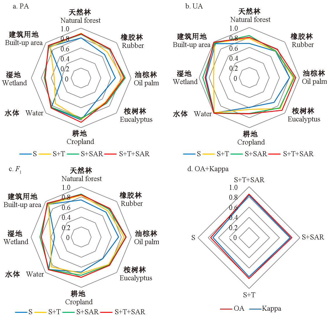
目的: 结合Sentinel-2光谱特征、纹理特征和Sentinel-1雷达后向散射特征,开展光学与雷达影像协同人工林树种分类研究,评价不同数据源和不同特征在树种分类中的作用,获取最优分类策略,为热带典型人工林树种精细识别提供新的技术途径。方法: 获取Sentinel-2光学影像43个光谱特征,将优选的Sentinel-2光谱特征与Sentinel-2纹理特征、Sentinel-1雷达后向散射特征组合,采用随机森林分类算法对研究区橡胶林、油棕林和桉树林进行精细提取,并评价不同特征对人工林树种识别的贡献。结果: 1)选择重要性排名前17的Sentinel-2光谱特征参与分类时,OOB score达最高值0.947 2,其中Sentinel-2的蓝波段、红边和近红外波段及其相应的植被指数在树种识别中重要性较高;2)Sentinel-2纹理特征和Sentinel-1雷达后向散射特征对于不同树种均具有一定差异性,可作为树种分类的有效特征;3)仅利用Sentinel-2光谱特征对橡胶林、油棕林和桉树林的区分度有限,生产者精度和用户精度的调和平均值(F1)分别为0.70、0.74和0.61;结合光谱特征、纹理特征和后向散射特征,3种人工林的分类精度达到最高,F1均大于0.80,同时其他地物的分类精度也有较大提高,总体分类精度为0.85,Kappa系数为0.83。结论: Sentinel-2光学影像的光谱特征是树种识别的重要基础,Sentinel-2光学影像派生的纹理特征及由Sentinel-1雷达影像提取的后向散射特征可为不同人工林树种识别提供有益补充。考虑到Sentinel-2和Sentinel-1较高的时间分辨率和空间分辨率,同时结合其光谱特征、纹理特征和后向散射特征对热带典型人工林树种进行精细识别具有极大潜力。
中图分类号:
黄翀,张晨晨,刘庆生,李贺,杨晓梅,刘高焕. 结合光学与雷达影像多特征的热带典型人工林树种精细识别[J]. 林业科学, 2021, 57(7): 80-91.
Chong Huang,Chenchen Zhang,Qingsheng Liu,He Li,Xiaomei Yang,Gaohuan Liu. Multi-Feature Classification of Optical and SAR Remote Sensing Images for Typical Tropical Plantation Species[J]. Scientia Silvae Sinicae, 2021, 57(7): 80-91.

图1
研究区位置及影像"

表1
基于Sentinel-2影像的光谱指数"
| 参考光谱指数 Reference spectral indices | 参考文献 References | 红边指数 Red-edge spectral indices | 参考文献 References |
| 归一化植被指数 Normalized difference vegetation index(NDVI) | 叶绿素绿指数 Chlorophyll green index(Chlorgreen) | ||
| 差值植被指数 Difference vegetation index(DVI) | 叶片花青素含量 Leaf anthocyanin content(LAnthoC) | ||
| 增强型植被指数 Enhanced vegetation index(EVI) | 叶片类胡萝卜素含量 Leaf carotenoid content(LCaroC) | ||
| 建成区指数 Built-up area index(BAI) | 叶片叶绿素含量 Leaf chlorophyll content(LChloC) | ||
| 绿度指数 Greenness index(GI) | 红边-短波红外归一化差异 Normalized difference of red-edge and SWIR2(NDrededgeSWIR) | ||
| 水分胁迫指数 Moisture stress index(MSI) | 红边归一化植被指数1 Red-edge normalized difference vegetation index 1(NDVIre1) | ||
| 归一化耕作指数 Normalized difference tillage index(NDTI) | 红边归一化植被指数2 Red-edge normalized difference vegetation index 2(NDVIre2) | ||
| 归一化绿波 Normalized green(Norm-G) | 红边归一化植被指数3 Red-edge normalized difference vegetation index 3(NDVIre3) | ||
| 归一化近红外 Normalized near infra-red(Norm-NIR) | 红边峰面积 Red-edge peak area(RededgePeakArea) | ||
| 归一化红波 Normalized red(Norm-R) | 简单蓝-红边1比值 Simple blue and red-edge 1 ratio (SR-BlueRededge1) | ||
| 归一化水体指数1 Normalized difference water index 1(NDWI1) | 简单蓝-红边2比值 Simple blue and red-edge 2 ratio (SR-BlueRededge2) | ||
| 归一化水体指数2 Normalized difference water index 2(NDWI2) | 简单蓝-红边3比值 Simple blue and red-edge 3 ratio (SR-BlueRededge3) | ||
| 归一化湿度指数 Normalized humidity index(NHI) | 归一化红边1 Normalized difference red-edge 1 (NDre1) | ||
| 土壤调节植被指数 Soil adjusted vegetation index(SAVI) | 归一化红边2 Normalized difference red-edge 2(NDre2) | ||
| 红-短波红外波段差值 Red-SWIR bands difference(RedSWIR1) | 归一化红边3 Chlorophyll index red-edge(CIre) | ||
| 比值植被指数 Ratio vegetation index(RVI) | |||
| 水体指数 Water body index(WBI) | |||
| 土壤耕作指数 Soil tillage index(STI) |
表2
分类特征组合"
| 序号 Number | 组合特征 Feature combinations | 描述 Description |
| 1 | S | Sentinel-2光谱特征 Sentinel-2 spectral features(S) |
| 2 | S+T | Sentinel-2光谱特征+Sentinel-2纹理特征 Sentinel-2 spectral features(S)+Sentinel-2 textural features(T) |
| 3 | S+SAR | Sentinel-2光谱特征+Sentinel-1雷达后向散射特征 Sentinel-2 spectural features(S)+Sentinel-1 SAR backscattering features(SAR) |
| 4 | S+T+SAR | Sentinel-2光谱特征+Sentinel-2纹理特征+Sentinel-1后向散射特征 Sentinel-2 spectural features(S)+Sentinel-2 textural features(T)+sentinel-1 SAR backscattering features(SAR) |

图2
Sentinel-2光谱特征重要性排序"
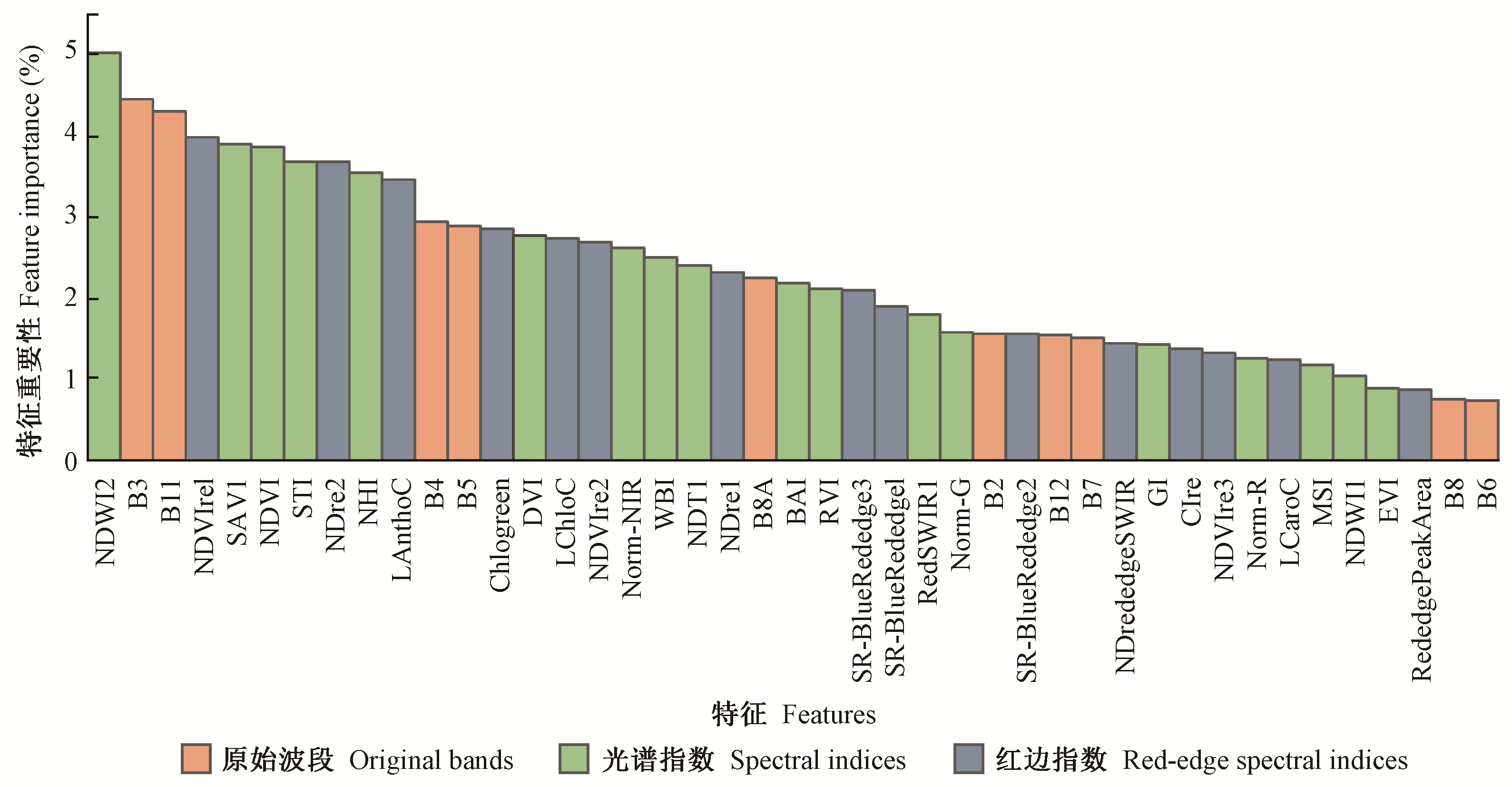

图3
Sentinel-2不同光谱特征组合模型的OOB score"
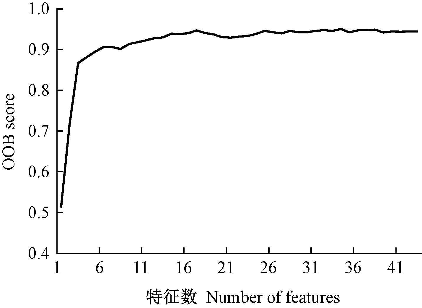

图4
重要特征波段统计"
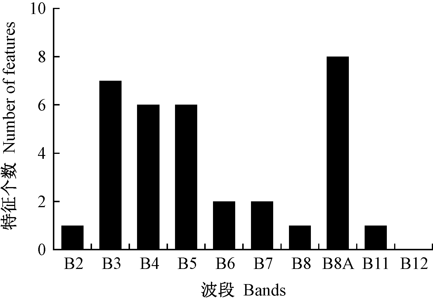
图5
天然林和不同人工林在纹理特征(a)和后向散射特征(b)上的特征值(均值±标准差) 图 5a的主坐标轴表示ASM、CON和COR特征值,次坐标轴表示ENT特征值;图 5b的主坐标轴表示VV、VH和Diff特征值,次坐标轴表示Ratio特征值。"
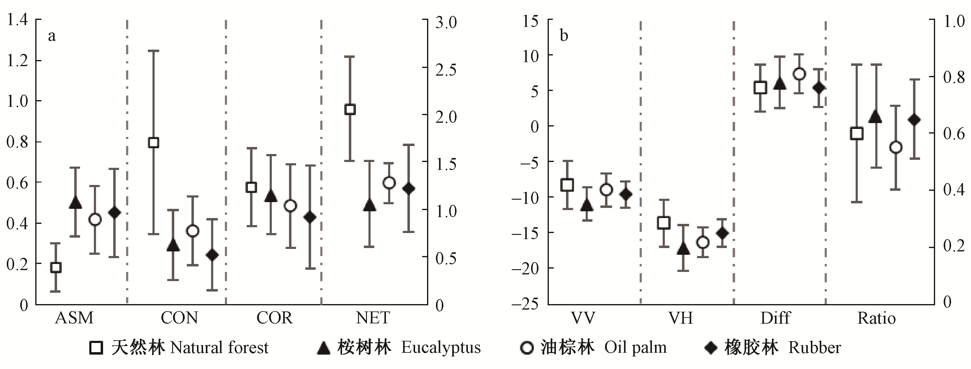
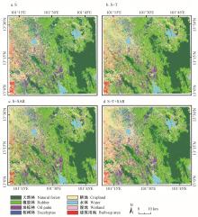
图6
不同特征组合的分类结果"

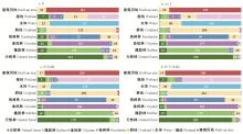
图7
不同特征组合分类结果的混淆矩阵"

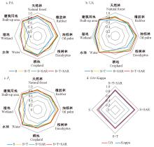
图8
不同特征组合分类精度对比"
| 韩涛, 潘剑君, 罗川, 等. 多时相Sentinel-2A与SPOT-7影像在油菜识别中的差异. 南京农业大学学报, 2018, 41 (4): 691- 700. | |
| Han T , Pan J J , Luo C , et al. Differences between multi-temporal Sentinel-2A and SPOT-7 imagery in rape identification. Journal of Nanjing Agricultural University, 2018, 41 (4): 691- 700. | |
| 何云, 黄翀, 李贺, 等. 基于Sentinel-2A影像特征优选的随机森林土地覆盖分类. 资源科学, 2019, 41 (5): 992- 1001. | |
| He Y , Huang C , Li H , et al. Land-cover classification of random forest based on Sentinel-2A image feature optimization. Resources Science, 2019, 41 (5): 992- 1001. | |
| 魏晶昱, 毛学刚, 方本煜, 等. 基于Landsat 8 OLI辅助的亚米级遥感影像树种识别. 北京林业大学学报, 2016, 38 (11): 23- 33. | |
| Wei J Y , Mao X G , Fang B Y , et al. Submeter remote sensing image recognition of trees based on Landsat 8 OLI support. Journal of Beijing Forestry University, 2016, 38 (11): 23- 33. | |
| 尹凌宇, 覃先林, 孙桂芬, 等. 基于高分二号多光谱数据的树种识别方法. 林业资源管理, 2016, (4): 121- 127. | |
| Yi L Y , Qin X L , Sun G F , et al. Tree species identification method based on GF-2 images. Forest Resources Management, 2016, (4): 121- 127. | |
|
Basiron Y . Palm oil production through sustainable plantations. European Journal of Lipid Science and Technology, 2007, 109 (4): 289- 295.
doi: 10.1002/ejlt.200600223 |
|
|
Baumann M , Ozdogan M , Kuemmerle T , et al. Using the Landsat record to detect forest-cover changes during and after the collapse of the Soviet Union in the temperate zone of European Russia. Remote Sensing of Environment, 2012, 124, 174- 184.
doi: 10.1016/j.rse.2012.05.001 |
|
| Bolyn C , Michez A , Gaucher P , et al. Forest mapping and species composition using supervised per pixel classification of Sentinel-2 imagery. Biotechnologie, Agronomie, Société et Environnement, 2018, 22 (3): 1- 16. | |
|
Breiman L . Random forests. Machine Learning, 2001, 45 (1): 5- 32.
doi: 10.1023/A:1010933404324 |
|
|
Broge N H , Mortensen J V . Deriving green crop area index and canopy chlorophyll density of winter wheat from spectral reflectance data. Remote Sensing of Environment, 2002, 81 (1): 45- 57.
doi: 10.1016/S0034-4257(01)00332-7 |
|
|
Broich M , Hansen M C , Potapov P , et al. Time-series analysis of multi-resolution optical imagery for quantifying forest cover loss in Sumatra and Kalimantan, Indonesia. International Journal of Applied Earth Observation and Geoinformation, 2011, 13 (2): 277- 291.
doi: 10.1016/j.jag.2010.11.004 |
|
|
Chatziantoniou A , Psomiadis E , Petropoulos G P . Co-orbital Sentinel 1 and 2 for LULC mapping with emphasis on wetlands in a mediterranean setting based on machine learning. Remote Sensing, 2017, 9 (12): 1259.
doi: 10.3390/rs9121259 |
|
|
Desclee B , Simonetti D , Mayaux P , et al. Multi-sensor monitoring system for forest cover change assessment in central Africa. IEEE Journal of Selected Topics in Applied Earth Observations and Remote Sensing, 2013, 6 (1): 110- 120.
doi: 10.1109/JSTARS.2013.2240263 |
|
|
Dian Y , Li Z , Pang Y . Spectral and texture features combined for forest tree species classification with airborne hyperspectral imagery. Journal of the Indian Society of Remote Sensing, 2015, 43 (1): 101- 107.
doi: 10.1007/s12524-014-0392-6 |
|
|
Dong J , Xiao X , Chen B , et al. Mapping deciduous rubber plantations through integration of PALSAR and multi-temporal Landsat imagery. Remote Sensing of Environment, 2013, 134, 392- 402.
doi: 10.1016/j.rse.2013.03.014 |
|
|
Dong J , Xiao X , Sheldon S , et al. A comparison of forest cover maps in mainland southeast Asia from multiple sources: PALSAR, MERIS, MODIS and FRA. Remote Sensing of Environment, 2012, 127, 60- 73.
doi: 10.1016/j.rse.2012.08.022 |
|
|
Dube T , Mutanga O , Adam E , et al. Intra-and-inter species biomass prediction in a plantation forest: testing the utility of high spatial resolution spaceborne multispectral rapideye sensor and advanced machine learning algorithms. Sensors, 2014, 14 (8): 15348- 15370.
doi: 10.3390/s140815348 |
|
| Féret J B , Asner G P . Tree species discrimination in tropical forests using airborne imaging spectroscopy. IEEE Transactions on Geoscience and Remote Sensing, 2012, 51 (1): 73- 84. | |
|
Fernández-Manso A , Fernández-Manso O , Quintano C . SENTINEL-2A red-edge spectral indices suitability for discriminating burn severity. International Journal of Applied Earth Observation and Geoinformation, 2016, 50, 170- 175.
doi: 10.1016/j.jag.2016.03.005 |
|
|
Gao B C . NDWI-a normalized difference water index for remote sensing of vegetation liquid water from space. Remote Sensing of Environment, 1996, 58 (3): 257- 266.
doi: 10.1016/S0034-4257(96)00067-3 |
|
|
George R , Padalia H , Kushwaha S . Forest tree species discrimination in western Himalaya using EO-1 Hyperion. International Journal of Applied Earth Observation and Geoinformation, 2014, 28, 140- 149.
doi: 10.1016/j.jag.2013.11.011 |
|
| Gessner U , Machwitz M , Conrad C , et al. Estimating the fractional cover of growth forms and bare surface in savannas. A multi-resolution approach based on regression tree ensembles. Remote Sensing of Environment, 2013, 129, 90- 102. | |
| Gitelson A A , Merzlyak M N . Spectral reflectance changes associated with autumn senescence of Aesculus hippocastanum L. and Acer platanoides L. leaves. Spectral Features and Relation to Chlorophyll Estimation. Journal of Plant Physiology, 1994, 143 (3): 286- 292. | |
|
Gitelson A A , Gritz Y , Merzlyak M N . Relationships between leaf chlorophyll content and spectral reflectance and algorithms for non-destructive chlorophyll assessment in higher plant leaves. Journal of Plant Physiology, 2003, 160 (3): 271- 282.
doi: 10.1078/0176-1617-00887 |
|
|
Gutiérrez-Vélez V H , DeFries R . Annual multi-resolution detection of land cover conversion to oil palm in the Peruvian Amazon. Remote Sensing of Environment, 2013, 129, 154- 167.
doi: 10.1016/j.rse.2012.10.033 |
|
|
Haralick R M . Statistical and structural approaches to texture. Proceedings of the IEEE, 1979, 67 (5): 786- 804.
doi: 10.1109/PROC.1979.11328 |
|
| Hojas-Gascon L , Belward A , Eva H , et al. Potential improvement for forest cover and forest degradation mapping with the forthcoming Sentinel-2 program. The International Archives of Photogrammetry, Remote Sensing and Spatial Information Sciences, 2015, 40 (7): 417- 421. | |
| Hyde P , Dubayah R , Walker W , et al. Mapping forest structure for wildlife habitat analysis using multi-sensor(LiDAR, SAR/InSAR, ETM+, QuickBird)synergy. Remote Sensing of Environment, 2006, 102 (1/2): 63- 73. | |
|
Immitzer M , Vuolo F , Atzberger C . First experience with Sentinel-2 data for crop and tree species classifications in central Europe. Remote Sensing, 2016, 8 (3): 166.
doi: 10.3390/rs8030166 |
|
|
Koh L P , Miettinen J , Liew S C , et al. Remotely sensed evidence of tropical peatland conversion to oil palm. Proceedings of the National Academy of Sciences, 2011, 108 (12): 5127- 5132.
doi: 10.1073/pnas.1018776108 |
|
|
Le Maire G , Francois C , Dufrene E . Towards universal broad leaf chlorophyll indices using PROSPECT simulated database and hyperspectral reflectance measurements. Remote Sensing of Environment, 2004, 89 (1): 1- 28.
doi: 10.1016/j.rse.2003.09.004 |
|
|
Li Z , Fox J M . Mapping rubber tree growth in mainland southeast Asia using time-series MODIS 250 m NDVI and statistical data. Applied Geography, 2012, 32 (2): 420- 432.
doi: 10.1016/j.apgeog.2011.06.018 |
|
|
Lichtenthaler H , Lang M , Sowinska M , et al. Detection of vegetation stress via a new high resolution fluorescence imaging system. Journal of Plant Physiology, 1996, 148 (5): 599- 612.
doi: 10.1016/S0176-1617(96)80081-2 |
|
|
Liu H Q , Huete A . A feedback based modification of the NDVI to minimize canopy background and atmospheric noise. IEEE Transactions on Geoscience and Remote Sensing, 1995, 33 (2): 457- 465.
doi: 10.1109/TGRS.1995.8746027 |
|
|
Locatelli B , Catterall C P , Imbach P , et al. Tropical reforestation and climate change: beyond carbon. Restoration Ecology, 2015, 23 (4): 337- 343.
doi: 10.1111/rec.12209 |
|
| Mngadi M , Odindi J , Peerbhay K , et al. Examining the effectiveness of Sentinel-1 and 2 imagery for commercial forest species mapping. Geocarto International, 2019, 36 (1): 1- 12. | |
|
Nooni I K , Duker A A , Van Duren I , et al. Support vector machine to map oil palm in a heterogeneous environment. International Journal of Remote Sensing, 2014, 35 (13): 4778- 4794.
doi: 10.1080/01431161.2014.930201 |
|
| Oon A , Ngo K D , Azhar R , et al. Assessment of ALOS-2 PALSAR-2 L-band and Sentinel-1 C-band SAR backscatter for discriminating between large-scale oil palm plantations and smallholdings on tropical peatlands. Remote Sensing Applications: Society and Environment, 2018, 13, 183- 190. | |
|
Payn T , Carnus J M , Freer-Smith P , et al. Changes in planted forests and future global implications. Forest Ecology and Management, 2015, 352, 57- 67.
doi: 10.1016/j.foreco.2015.06.021 |
|
|
Peerbhay K Y , Mutanga O , Ismail R . Investigating the capability of few strategically placed Worldview-2 multispectral bands to discriminate forest species in KwaZulu-Natal, south Africa. IEEE Journal of Selected Topics in Applied Earth Observations and Remote Sensing, 2014, 7 (1): 307- 316.
doi: 10.1109/JSTARS.2013.2262634 |
|
|
Radoux J , Chomé G , Jacques D , et al. Sentinel-2's potential for sub-pixel landscape feature detection. Remote Sensing, 2016, 8 (6): 488.
doi: 10.3390/rs8060488 |
|
| Ramoelo A , Cho M , Mathieu R , et al. Potential of Sentinel-2 spectral configuration to assess rangeland quality. Journal of Applied Remote Sensing, 2015, 9 (1): 94- 96. | |
|
Rodriguez-Galiano V F , Ghimire B , Rogan J , et al. An assessment of the effectiveness of a random forest classifier for land-cover classification. ISPRS Journal of Photogrammetry and Remote Sensing, 2012, 67, 93- 104.
doi: 10.1016/j.isprsjprs.2011.11.002 |
|
|
Shi Y , Skidmore A K , Wang T , et al. Tree species classification using plant functional traits from LiDAR and hyperspectral data. International Journal of Applied Earth Observation and Geoinformation, 2018, 73, 207- 219.
doi: 10.1016/j.jag.2018.06.018 |
|
|
Somers B , Verbesselt J , Ampe E M , et al. Spectral mixture analysis to monitor defoliation in mixed-aged Eucalyptus globulus Labill plantations in southern Australia using Landsat5-TM and EO-1 Hyperion data. International Journal of Applied Earth Observation and Geoinformation, 2010, 12 (4): 270- 277.
doi: 10.1016/j.jag.2010.03.005 |
|
|
Sothe C , Almeida C , Liesenberg V , et al. Evaluating Sentinel-2 and Landsat-8 data to map sucessional forest stages in a subtropical forest in southern Brazil. Remote Sensing, 2017, 9 (8): 838.
doi: 10.3390/rs9080838 |
|
|
Sripada R P , Heiniger R W , White J G , et al. Aerial color infrared photography for determining early in-season nitrogen requirements in corn. Agronomy Journal, 2006, 98 (4): 968- 977.
doi: 10.2134/agronj2005.0200 |
|
|
Torbick N , Ledoux L , Salas W , et al. Regional mapping of plantation extent using multisensor imagery. Remote Sensing, 2016, 8 (3): 236.
doi: 10.3390/rs8030236 |
|
| Van Deventer A , Ward A , Gowda P , et al. Using Thematic Mapper data to identify contrasting soil plains and tillage practices. Photogrammetric Engineering and Remote Sensing, 1997, 63, 87- 93. | |
|
Wu H , Li Z L . Scale issues in remote sensing: a review on analysis, processing and modeling. Sensors, 2009, 9 (3): 1768- 1793.
doi: 10.3390/s90301768 |
|
| Wulf H, Stuhler S. 2015. Sentinel-2: land cover, preliminary user feedback on Sentinel-2A data. In Proceedings of the Sentinel-2A expert users technical meeting, 29-30 September 2015, Frascati, Italy. | |
|
Wurm M , Taubenb ck H , Weigand M , et al. Slum mapping in polarimetric SAR data using spatial features. Remote Sensing of Environment, 2017, 194, 190- 204.
doi: 10.1016/j.rse.2017.03.030 |
|
|
Zhang Y , Zhang H , Lin H . Improving the impervious surface estimation with combined use of optical and SAR remote sensing images. Remote Sensing of Environment, 2014, 141, 155- 167.
doi: 10.1016/j.rse.2013.10.028 |
| [1] | 房焕英,肖胜生,余小芳,熊永,欧阳勋志,秦晓蕾. 湿地松人工林土壤呼吸及其组分对模拟酸雨的响应[J]. 林业科学, 2021, 57(7): 20-31. |
| [2] | 王金池,黄清麟,严铭海,黄如楚,郑群瑞. 由邓恩桉人工林转型的7年生丝栗栲天然林特征[J]. 林业科学, 2021, 57(1): 12-19. |
| [3] | 侯文军,邹明,李宝福,俞元春. 施用草甘膦对桉树人工林土壤理化性质的影响[J]. 林业科学, 2020, 56(8): 20-26. |
| [4] | 竹万宽,许宇星,王志超,杜阿朋. 中国桉树人工林生物量估算系数及影响要素[J]. 林业科学, 2020, 56(5): 1-11. |
| [5] | 冯鑫炜,张志强,许行,律江,张海泉,孟祥雪. 欧美杨人工林生态系统净碳交换对环境因子响应的时滞[J]. 林业科学, 2020, 56(2): 12-23. |
| [6] | 沈玉林,王哲,平立娟,李美玲,刘小燕,王喜明. 不同干燥方法对人工林樟子松木材干燥特性的影响[J]. 林业科学, 2020, 56(11): 151-158. |
| [7] | 刘辉,牟长城,吴彬,张悦,井立杰. 黑龙江帽儿山温带森林类型土壤非生长季温室气体排放特征[J]. 林业科学, 2020, 56(10): 11-25. |
| [8] | 栗旭升,李虎,陈冬花,刘玉锋,刘赛赛,刘聪芳,胡国庆. 联合GF-5与GF-6卫星数据的多分类器组合亚热带树种识别[J]. 林业科学, 2020, 56(10): 93-104. |
| [9] | 张雷, 孙鹏森, 刘世荣. 川西亚高山森林不同恢复阶段生长季蒸腾特征[J]. 林业科学, 2020, 56(1): 1-9. |
| [10] | 吴项乾,曹林,申鑫,汪贵斌,曹福亮. 基于无人机激光雷达的银杏人工林有效叶面积指数估测[J]. 林业科学, 2020, 56(1): 74-86. |
| [11] | 陈栋,吴保国,王姗姗,苏晓慧,陈玉玲,李宜瑾. 面向人工林经营的模型库和方法库服务平台[J]. 林业科学, 2020, 56(1): 87-102. |
| [12] | 韩新生, 王彦辉, 李振华, 王艳兵, 于澎涛, 熊伟. 六盘山半干旱区华北落叶松人工林林下日蒸散特征及其影响因子[J]. 林业科学, 2019, 55(9): 11-21. |
| [13] | 陈东升, 李凤日, 孙晓梅, 张守攻. 基于节子分析技术构建落叶松人工林树冠基部高动态模型[J]. 林业科学, 2019, 55(9): 103-110. |
| [14] | 叶钰倩, 赵家豪, 刘畅, 关庆伟. 间伐强度对马尾松人工林根际与非根际土壤中性糖特征的影响[J]. 林业科学, 2019, 55(8): 28-35. |
| [15] | 陈秀波, 朱德全, 赵晨晨, 张路路, 陈立新, 段文标. 凉水国家自然保护区不同林型红松林土壤nosZ型反硝化微生物群落组成和多样性分析[J]. 林业科学, 2019, 55(8): 106-117. |
| 阅读次数 | ||||||
|
全文 |
|
|||||
|
摘要 |
|
|||||