
林业科学 ›› 2025, Vol. 61 ›› Issue (2): 50-61.doi: 10.11707/j.1001-7488.LYKX20220728
单博文1( ),李祎1,覃钧1,石雷1,2,*()
收稿日期:2022-10-26
出版日期:2025-02-25
发布日期:2025-03-03
通讯作者:
石雷
E-mail:15532212038@163.com;leishi@icbr.ac.cn
基金资助:
Bowen Shan1(),Yi Li1,Jun Qin1,Lei Shi1,2,*()
Received:2022-10-26
Online:2025-02-25
Published:2025-03-03
Contact:
Lei Shi
E-mail:15532212038@163.com;leishi@icbr.ac.cn
摘要:
目的: 探究中国竹林分布区极端气候的时空变化,揭示极端气候事件发生的空间分异及其时间变化规律,为未来不同竹林分布区应对极端气候事件提供参考。方法: 基于1960—2020年气象数据,利用中国天气发生器(NCC/GU-WG Version 2.0)对2021—2050年的气象数据进行预测,借助RClimDex软件计算与竹林生长相关的10个极端气候指标,采用累积距平、Sen趋势、Mann-Kendall检验和克里金插值法研究1960—2050年中国竹林分布区极端气候的时空分布及其变化规律。结果: 90年来,中国竹林区的夏季高温日数、日最高温的极高值、日最低温的极高值、日最高温的极低值和日最低温的极低值每10年分别上升3.52天、0.15 ℃、0.21 ℃、0.26 ℃和0.4 ℃,霜冻日数每10 年减少1.79天,上述极端温度指标大约在2000年前后存在突变点;单日最大降水量、连续5日最大降水量、强降水量和年均日降水强度每10年分别上升1.58 mm、2.13 mm、12.99 mm和0.2 mm?d?1,上述极端降水指标在1994年前后存在突变点。从空间上来看,日最高温和日最低温的极高值在整个竹林区域都较大,而夏季高温日数的高值区则位于低纬度的竹林区;日最高温和日最低温的极低值的低值区,以及霜冻日数的高值区主要位于内陆高纬度的散生竹区。表征极端降水的单日最大降水量、连续5日最大降水量、强降水量和年均日降水强度的高值区位于南方以及沿海区域,而四川混生竹区具有较高的极端降水指标和极低的极端低温指标。结论: 在中国竹林分布区发生的极端温度和降水事件都具有明显的增加趋势,且大部分极端温度指标和极端降水指标分别在2000年前后和1994年前后存在突变点。内陆高纬度区域的散生竹区易遭受极端低温事件的影响,低纬度竹林区可能会遭受旱涝两极灾害的影响,而四川混生竹区遭受极端温度和极端降水事件的风险均相对较高。
中图分类号:
单博文,李祎,覃钧,石雷. 1960—2050年中国竹林区极端气候的时空变化[J]. 林业科学, 2025, 61(2): 50-61.
Bowen Shan,Yi Li,Jun Qin,Lei Shi. Spatiotemporal Change of the Extreme Climate in China’s Bamboo Forest during 1960—2050[J]. Scientia Silvae Sinicae, 2025, 61(2): 50-61.
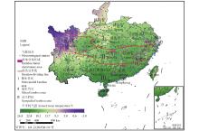
图1
中国竹林分布"

表1
所选极端气候指标的含义"
| 类型 Type | 名称 Name | 定义 Definition |
| 温度指标 Temperature indices | 夏季高温日数 Number of high temperature days in summer /d | 每年内日最高温度>25 ℃的日数 Annual count when daily maximum temperature larger than 25 ℃ |
| 日最高温的极高值 Maximum values of daily maximum temperatures/℃ | 每年内日最高温度的最大值 Maximum value of daily maximum temperature in a year | |
| 日最高温的极低值 Minimum values of daily maximum temperatures/℃ | 每年内日最高温度的最小值 Minimum value of daily maximum temperature in a year | |
| 日最低温的极高值 Maximum values of daily minimum temperatures/℃ | 每年内日最低温度的最大值 Maximum value of daily minimum temperature in a year | |
| 日最低温的极低值 Minimum values of daily minimum temperatures/℃ | 每年内日最低温度的最小值 Minimum value of daily minimum temperature in a year | |
| 霜冻日数 Frost days/d | 每年内日最低温度<0 ℃的日数 Annual count when daily minimum temperature below 0 ℃ | |
| 降水指标 Precipitation indices | 单日最大降水量 Maximum daily precipitation/mm | 每年内最大1日降水量 Maximum 1-day precipitation in a year |
| 连续5日最大降水量 Maximum five-day precipitation/mm | 每年内连续5日最大降水量 Maximum consecutive 5-day precipitation in a year | |
| 强降水量 Heavy precipitation/mm | 每年内日降水量大于第95%分位值的降水量之和 Annual total precipitation when daily precipitation larger than 95th percentile | |
| 年均日降水强度 Mean annual daily precipitation intensity/(mm?d?1) | 每年内日降水量≥1 mm的总量与总日数之比 Annual total precipitation divided by the number of wet days (defined as precipitation no smaller than 1 mm) in a year |
表2
各极端气候指标克里金插值结果的交叉验证"
| 指标 Index | 均方根预测误差 Root-mean-square prediction error | 标准平均值 Standardized average value | 标准均方根预测误差 Standardized root-mean-square prediction error | 平均标准误差 Standard error of the mean |
| 夏季高温日数 Number of high temperature days in summer/d | 33.73 | ?0.005 3 | 0.99 | 33.84 |
| 日最高温的极高值 Maximum values of daily maximum temperatures/℃ | 2.56 | ?0.006 3 | 1.00 | 2.56 |
| 日最高温的极低值 Minimum values of daily maximum temperatures/℃ | 2.21 | ?0.002 2 | 1.02 | 2.17 |
| 日最低温的极高值 Maximum values of daily minimum temperatures/℃ | 1.97 | ?0.000 4 | 1.02 | 1.94 |
| 日最低温的极低值 Minimum values of daily minimum temperatures/℃ | 2.57 | 0.001 0 | 1.06 | 2.42 |
| 霜冻日数 Frost days/d | 20.40 | 0.001 1 | 1.085 | 18.77 |
| 单日最大降水量 Maximum daily precipitation/mm | 12.04 | 0.001 2 | 0.93 | 13.14 |
| 连续5日最大降水量 Maximum five-day precipitation/mm | 23.02 | ? | 0.95 | 24.75 |
| 强降水量 Heavy precipitation/mm | 59.99 | ?0.002 8 | 1.00 | 59.48 |
| 年均日降水强度 Mean annual daily precipitation intensity/(mm?d?1) | 0.85 | ?0.001 2 | 0.85 | 1.01 |
图2
日最高温、日最低温和日降水量的模拟与实测结果分布及拟合线"
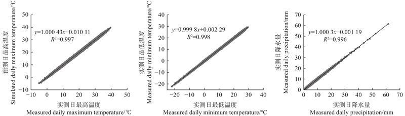
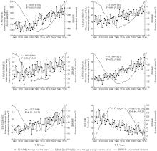
图3
中国竹林区极端温度的时间变化趋势"


图4
中国竹林区极端温度的空间分布"


图5
中国竹林区极端降水的时间变化趋势"
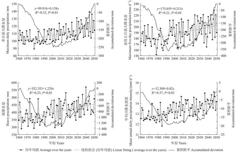

图6
中国竹林区极端降水的空间分布"

| 曹 晴, 郝振纯, 傅晓洁, 等. 1960—2017年中国极端气候要素时空变化分析. 人民黄河, 2020, 42 (2): 11- 17. | |
| Cao Q, Hao Z C, Fu X J, et al. Analysis of spatial-temporal changes of extreme climatic elements in China from 1960 to 2017. Yellow River, 2020, 42 (2): 11- 17. | |
|
丁一汇, 王会军. 近百年中国气候变化科学问题的新认识. 科学通报, 2016, 61 (10): 1029- 1041.
doi: 10.1360/N972015-00638 |
|
|
Ding Y H, Wang H J. Newly acquired knowledge on the scientific issues related to climate change over the recent 100 years in China. Chinese Science Bulletin, 2016, 61 (10): 1029- 1041.
doi: 10.1360/N972015-00638 |
|
| 高 滢, 孙 虎, 徐崟尧, 等. 陕西省植被覆盖时空变化及其对极端气候的响应. 生态学报, 2022, 42 (3): 1022- 1033. | |
| Gao Y, Sun H, Xu Y Y, et al. Temporal and spatial variation of vegetation cover and its response to extreme climate in Shaanxi Province. Acta Ecologica Sinica, 2022, 42 (3): 1022- 1033. | |
| 胡超宗. 紫竹笋期生长规律的研究. 竹子研究汇刊, 1982, 1 (1): 57- 69. | |
| Hu C Z. A preliminary study on the growth of bamboo shoots of Phyllostachys nigra. Journal of Bamboo Research, 1982, 1 (1): 57- 69. | |
| 胡宜昌, 董文杰, 何 勇. 21世纪初极端天气气候事件研究进展. 地球科学进展, 2007, 22 (10): 1066- 1075. | |
| Hu Y C, Dong W J, He Y. Progress of the study of extreme weather and climate events at the beginning of the twenty first century. Advances in Earth Science, 2007, 22 (10): 1066- 1075. | |
| 姜勇强, 张维桓, 周祖刚, 等. 不等距分层中尺度η坐标暴雨模式的设计及数值试验. 热带气象学报, 2001, 17 (3): 301- 307. | |
| Jiang Y Q, Zhang W H, Zhou Z G, et al. Design of eta-coordinate mesoscale rainstorm model and numerical simulation. Journal of Tropical Meteorology, 2001, 17 (3): 301- 307. | |
| 孔 锋, 史培军, 方 建, 等. 全球变化背景下极端降水时空格局变化及其影响因素研究进展和展望. 灾害学, 2017, 32 (2): 165- 174. | |
| Kong F, Shi P J, Fang J, et al. Advances and prospects of spatiotemporal pattern variation of extreme precipitation and its affecting factors under the background of global climate change. Journal of Catastrophology, 2017, 32 (2): 165- 174. | |
| 李俊晓, 李朝奎, 殷智慧. 基于ArcGIS的克里金插值方法及其应用. 测绘通报, 2013, (9): 87- 90, 97. | |
| Li J X, Li C K, Yin Z H. ArcGIS based Kriging interpolation method and its application. Bulletin of Surveying and Mapping, 2013, (9): 87- 90, 97. | |
| 李龙有, 张培新. 干旱和高温危害毛竹竹笋—幼竹生长初报. 竹子研究汇刊, 1987, 6 (4): 55- 59. | |
| Li L Y, Zhang P X. First report on high temperature and drought damage shoots and young bamboos(ph. pubescens). Journal of Bamboo Research, 1987, 6 (4): 55- 59. | |
| 李 应, 陈双林, 李迎春, 等, 2011. 气候因子对竹子生长的影响研究综述. 竹子研究汇刊, 30(3): 9−12, 17. | |
| Li Y, Chen S L, Li Y C, et al. 2011. Research review in the effects of climate factors on bamboo growth. Journal of Bamboo Research, 30(3): 9−12, 17. [in Chinese] | |
| 李迎春, 杨清平, 郭子武, 等, 2015. 毛竹林持续高温干旱灾害特征及影响因素分析. 林业科学研究, 28(5): 646−653. | |
| Li Y C, Yang Q P, Guo Z W, et al. 2015. Damage characteristics of Phyllostachys edulis stands under continuous high temperature and drought. Forest Research, 28(5): 646−653. [in Chinese] | |
| 廖要明, 陈德亮, 高 歌, 等. 中国天气发生器降水模拟参数的气候变化特征. 地理学报, 2009, 64 (7): 871- 878. | |
| Liao Y M, Chen D L, Gao G, et al. Impacts of climate changes on parameters of a weather generator for daily precipitation in China. Acta Geographica Sinica, 2009, 64 (7): 871- 878. | |
|
廖要明, 刘绿柳, 陈德亮, 等. 中国天气发生器模拟非降水变量的效果评估. 气象学报, 2011, 69 (2): 310- 319.
doi: 10.11676/qxxb2011.026 |
|
|
Liao Y M, Liu L L, Chen D L, et al. An evaluation of the BCC/RC-WG’s performance in simulating dailynon-precipitation variables in China. Acta Meteorologica Sinica, 2011, 69 (2): 310- 319.
doi: 10.11676/qxxb2011.026 |
|
|
廖要明, 张 强, 陈德亮. 中国天气发生器的降水模拟. 地理学报, 2004, 59 (5): 689- 698.
doi: 10.11821/xb200405006 |
|
|
Liao Y M, Zhang Q, Chen D L. Precipitation simulation in China with a weather generator. Acta Geographica Sinica, 2004, 59 (5): 689- 698.
doi: 10.11821/xb200405006 |
|
| 刘 琳, 徐宗学. 西南5省市极端气候指数时空分布规律研究. 长江流域资源与环境, 2014, 23 (2): 294- 301. | |
| Liu L, Xu Z X. Spatiotemporal distribution of the extreme climate indices in the five southwestern provinces of China. Resources and Environment in the Yangtze Basin, 2014, 23 (2): 294- 301. | |
|
刘学华, 季致建, 吴洪宝, 等. 中国近40年极端气温和降水的分布特征及年代际差异. 热带气象学报, 2006, 22 (6): 618- 624.
doi: 10.3969/j.issn.1004-4965.2006.06.015 |
|
|
Liu X H, Ji Z J, Wu H B, et al. Distributing characteristics and interdecadal difference of daily temperature and precipitation extremes in China for latest 40 years. Journal of Tropical Meteorology, 2006, 22 (6): 618- 624.
doi: 10.3969/j.issn.1004-4965.2006.06.015 |
|
| 罗 玉, 陈 超, 马振峰, 等. 1961—2015年四川省汛期极端降水指数时空变化研究. 西南大学学报(自然科学版), 2018, 40 (9): 133- 141. | |
| Luo Y, Chen C, Ma Z F, et al. Spatial-temporal variation of extreme precipitation indices during the main flood season in 1961—2015 in Sichuan. Journal of Southwest University (Natural Science Edition), 2018, 40 (9): 133- 141. | |
| 马齐云, 张继权, 来 全, 等. 1960—2014年松嫩草地极端气候事件的时空变化. 应用生态学报, 2017, 28 (6): 1769- 1778. | |
| Ma Q Y, Zhang J Q, Lai Q, et al. Temporal and spatial variations of extreme climatic events in Songnen Grassland, Northeast China during 1960—2014. Chinese Journal of Applied Ecology, 2017, 28 (6): 1769- 1778. | |
| 穆兴民, 李 靖, 王 飞, 等. 黄河天然径流量年际变化过程分析. 干旱区资源与环境, 2003, 17 (2): 1- 5. | |
| Mu X M, Li J, Wang F, et al. Analysis on the annual natural runoff variety process of the Yellow River. Journal of Arid Land Resources & Environment, 2003, 17 (2): 1- 5. | |
| 潘晓华. 2002. 近五十年中国极端温度和降水事件变化规律的研究. 北京: 中国气象科学研究院. | |
| Pan X H. 2002. The spatial and temporal characteristics of change of temperature and precipitation extremes over China during the second half of the 20-(Th). Beijing: Chinese Academy of Meteorological Sciences | |
| 裴晶晶. 2017. 毛竹林受高温干旱影响的特征及其自恢复能力研究. 杭州: 浙江农林大学. | |
| Pei J J. 2017. Study on the characteristics and self-recovery ability of moso bamboo forest by high temperature and drought. Hangzhou: Zhejiang A & F University | |
| 齐庆华, 蔡榕硕, 郭海峡. 中国东部气温极端特性及其气候特征. 地理科学, 2019, 39 (8): 1340- 1350. | |
| Qi Q H, Cai R S, Guo H X. The climatic variations of temperature extremes in the eastern of China. Scientia Geographica Sinica, 2019, 39 (8): 1340- 1350. | |
|
钱维宏, 符娇兰, 张玮玮, 等. 近40年中国平均气候与极值气候变化的概述. 地球科学进展, 2007, 22 (7): 673- 684.
doi: 10.3321/j.issn:1001-8166.2007.07.003 |
|
|
Qian W H, Fu J L, Zhang W W, et al. Changes in mean climate and extreme cliamte in China during the last 40 years. Advances in Earth Science, 2007, 22 (7): 673- 684.
doi: 10.3321/j.issn:1001-8166.2007.07.003 |
|
| 任国玉, 封国林, 严中伟. 中国极端气候变化观测研究回顾与展望. 气候与环境研究, 2010, 15 (4): 337- 353. | |
| Ren G Y, Feng G L, Yan Z W. Progresses in observation studies of climate extremes and changes in China’s mainland. Climatic and Environmental Research, 2010, 15 (4): 337- 353. | |
| 时明芝. 2011. 全球气候变化对中国森林影响的研究进展. 中国人口·资源与环境, 21(7): 68-72. | |
| Shi M Z. 2011. The influence of the global climate change on forests in China. China Population, Resources and Environment, 21(7): 68-72. [in Chinese] | |
| 苏文会, 范少辉, 张文元, 等. 灾后补救措施对雪压毛竹林恢复效果研究. 林业科学研究, 2010, 23 (1): 89- 92. | |
| Su W H, Fan S H, Zhang W Y, et al. Study on the recover effect of remedial measures on moso bamboo stands after frost and snow disaster. Forest Research, 2010, 23 (1): 89- 92. | |
| 陶诗言, 卫 捷. 2008年1月我国南方严重冰雪灾害过程分析. 气候与环境研究, 2008, 13 (4): 337- 350. | |
| Tao S Y, Wei J. Severe snow and freezing-rain in January 2008 in the Southern China. Climatic and Environmental Research, 2008, 13 (4): 337- 350. | |
| 汪宝龙, 张明军, 魏军林, 等. 西北地区近50a气温和降水极端事件的变化特征. 自然资源学报, 2012, 27 (10): 1720- 1733. | |
| Wang B L, Zhang M J, Wei J L, et al. The change in extreme events of temperature and precipitation over Northwest China in recent 50 years. Journal of Natural Resources, 2012, 27 (10): 1720- 1733. | |
| 王晓利. 2017. 中国沿海极端气候变化及其对NDVI的影响特征研究. 烟台: 中国科学院烟台海岸带研究所. | |
| Wang X L. 2017. Variation of extreme climate and its impact on NDVI in the coastal area of China. Yantai: Yantai Institute of Coastal Zone Research, Chinese Academy of Sciences. | |
| 王志福, 钱永甫. 中国极端降水事件的频数和强度特征. 水科学进展, 2009, 20 (1): 1- 9. | |
| Wang Z F, Qian Y F. Frequency and intensity of extreme precipitation events in China. Advances in Water Science, 2009, 20 (1): 1- 9. | |
| 武金翠, 周 军, 张 宇, 等. 毛竹林固碳增汇价值的动态变化: 以福建省为例. 林业科学, 2020, 56 (4): 181- 187. | |
| Wu J C, Zhou J, Zhang Y, et al. Carbon sequestration value and its change of Phyllostachys edulis forest: a case study of Fujian Province. Scientia Silvae Sinicae, 2020, 56 (4): 181- 187. | |
| 雅 茹, 丽 娜, 银 山, 等. 1960—2015年内蒙古极端气候事件的时空变化特征. 水土保持研究, 2020, 27 (3): 106- 112. | |
| Ya R, Li N, Yin S, et al. Characteristics of temporal and spatial variation of extreme climate events in Inner Mongolia during the period 1960—2015. Research of Soil and Water Conservation, 2020, 27 (3): 106- 112. | |
| 杨方兴. 2012. 内蒙古地区极端气候事件时空变化及其与NDVI的相关性. 西安: 长安大学. | |
| Yang F X. 2012. Trends of extreme daily precipitation and temperature and the correlation with NDVI in Inner Mongolia. Xi’an: Chang’an University. | |
| 杨 萍, 侯 威, 封国林. 中国极端气候事件的群发性规律研究. 气候与环境研究, 2010, 15 (4): 365- 370. | |
| Yang P, Hou W, Feng G L. A study of the characteristics of the cluster extreme events in China. Climatic and Environmental Research, 2010, 15 (4): 365- 370. | |
| 张 宇, 岳祥华, 漆良华, 等. 利用异速生长关系和地统计方法估算武夷山南麓毛竹林生物量. 生态学杂志, 2016, 35 (7): 1957- 1962. | |
| Zhang Y, Yue X H, Qi L H, et al. Estimation of Phyllostachys edulis forest biomass in southern Wuyishan Mountain using allometric equation and geostatistical technique. Chinese Journal of Ecology, 2016, 35 (7): 1957- 1962. | |
| 张志达. 中国竹子资源的现状及展望. 国土绿化, 1998, (4): 12- 13. | |
| Zhang Z D. Present situation and prospect of bamboo resources in China. Land Greening, 1998, (4): 12- 13. | |
|
赵 煊, 卞 韬, 任国玉, 等. 地理因子在北疆极端气温趋势变化中的作用. 地理科学进展, 2021, 40 (4): 681- 692.
doi: 10.18306/dlkxjz.2021.04.012 |
|
|
Zhao X, Bian T, Ren G Y, et al. Possible impacts of geographical factors on long-term trends of extreme temperature indices over northern Xinjiang, China. Progress in Geography, 2021, 40 (4): 681- 692.
doi: 10.18306/dlkxjz.2021.04.012 |
|
| 甄 英, 季 薇, 李传辉, 等. 四川省地表温度变化特征及气象因素影响分析. 内江师范学院学报, 2021, 36 (6): 44- 49. | |
| Zhen Y, Ji W, Li C H, et al. Spatio-temporal variation characteristics of land surface temperature and analysis of meteorological factors in Sichuan Province. Journal of Neijiang Normal University, 2021, 36 (6): 44- 49. | |
| 周芳纯. 1998. 竹林培育学. 北京: 中国林业出版社. | |
| Zhou F C. 1998. Bamboo forest cultivation. Beijing: China Forestry Publishing House. [in Chinese] | |
| Alexander L V, Zhang X, Peterson T C, et al. 2006. Global observed changes in daily climate extremes of temperature and precipitation. Journal of Geophysical Research: Atmospheres, 111(D5): e2005jd006290. | |
|
Allen C D, Macalady A K, Chenchouni H, et al. A global overview of drought and heat-induced tree mortality reveals emerging climate change risks for forests. Forest Ecology and Management, 2010, 259 (4): 660- 684.
doi: 10.1016/j.foreco.2009.09.001 |
|
|
Cohen J M, Fink D, Zuckerberg B. Avian responses to extreme weather across functional traits and temporal scales. Global Change Biology, 2020, 26 (8): 4240- 4250.
doi: 10.1111/gcb.15133 |
|
|
Deng H J, Chen Y N, Shi X, et al. Dynamics of temperature and precipitation extremes and their spatial variation in the arid region of Northwest China. Atmospheric Research, 2014, 138, 346- 355.
doi: 10.1016/j.atmosres.2013.12.001 |
|
| Dong D Y, Hui A, Duan H, et al. Changes in climate factors and extreme climate events in south China during 1961—2010. Advances in Climate Change Research, 2013, 4 (1): 1- 11. | |
| Heino R, Brázdil R, Førland E, et al. 1999. Progress in the study of climatic extremes in northern and central Europe. Weather and Climate Extremes. Dordrecht: Springer Netherlands, 151−181. | |
|
Insua-Costa D, Senande-Rivera M, Llasat M C, et al. A global perspective on western Mediterranean precipitation extremes. NPJ Climate and Atmospheric Science, 2022, 5, 9.
doi: 10.1038/s41612-022-00234-w |
|
| IPCC. 2021. Climate change 2021: the physical science basis. Contribution of working group i to the sixth assessment report of the intergovernmental panel on climate change. Cambridge, United Kingdom and New York, USA: Cambridge University Press. | |
| Karl T R, Nicholls N, Ghazi A. 1999. CLIVAR/GCOS/WMO workshop on indices and indicators for climate extremes workshop summary// Karl T R, Nicholls N, Ghazi A. Weather and Climate Extremes. Dordrecht: Springer Netherlands, 3−7. | |
| Li Z L, Zhang X L, Clarke K C, et al. An automatic variogram modeling method with high reliability fitness and estimates. Computers & Geosciences, 2018, 120, 48- 59. | |
|
Pei F S, Zhou Y, Xia Y. Assessing the impacts of extreme precipitation change on vegetation activity. Agriculture, 2021, 11 (6): 487.
doi: 10.3390/agriculture11060487 |
|
|
Sen P K. Estimates of the regression coefficient based on Kendall’s tau. Journal of the American Statistical Association, 1968, 63 (324): 1379- 1389.
doi: 10.1080/01621459.1968.10480934 |
|
|
Su B D, Gemmer M, Jiang T. Spatial and temporal variation of extreme precipitation over the Yangtze River Basin. Quaternary International, 2008, 186 (1): 22- 31.
doi: 10.1016/j.quaint.2007.09.001 |
|
| You Q L, Kang S C, Aguilar E, et al. Changes in daily climate extremes in China and their connection to the large scale atmospheric circulation during 1961–2003. Climate Dynamics, 2011, 36 (11): 2399- 2417. | |
| Zhou B Z, Li Z C, Wang X M, et al. Impact of the 2008 ice storm on moso bamboo plantations in southeast China. Journal of Geophysical Research, 2011, 116, G00H06. |
| [1] | 包广道,刘婷,张忠辉,任志彬,翟畅,丁铭铭,姜雪菲. 长白山区4种针叶林有效叶面积指数遥感精细反演及空间分布规律[J]. 林业科学, 2024, 60(5): 127-138. |
| [2] | 艾萨迪拉·玉苏甫,玉米提·哈力克,巴比尔江·迪力夏提,雷诚,魏建新,阿不都拉·阿不力孜,崔健泺,何熙祥. 基于激光雷达数据的塔里木河下游胡杨种群空间分布格局和种内竞争关系[J]. 林业科学, 2024, 60(4): 31-39. |
| [3] | 沈琛琛,肖文发,朱建华,曾立雄,陈吉臻,黄志霖. 基于机器学习算法的华中天然林土壤有机碳特征与关键影响因子[J]. 林业科学, 2024, 60(3): 65-77. |
| [4] | 陈睿,汤孟平. 天目山针阔混交林与常绿阔叶林的空间结构比较[J]. 林业科学, 2023, 59(5): 21-31. |
| [5] | 于帅,蔡体久,张丕德,任铭磊,张海宇,琚存勇. 边缘校正方法对空间结构参数影响的尺度效应[J]. 林业科学, 2023, 59(10): 57-65. |
| [6] | 李林,魏识广,叶万辉,练琚愉,温智峰,周景钢. 南亚热带常绿阔叶林优势种组的空间分布格局及组间关联[J]. 林业科学, 2022, 58(9): 16-24. |
| [7] | 粟佳琳,王娟,范春雨,张春雨,赵秀海. 吉林蛟河针阔混交林群落邻体竞争效应[J]. 林业科学, 2022, 58(5): 187-194. |
| [8] | 王丞,李海波,杨朝辉,毕兴,樊涵,粟海军,胡灿实,张明明. 梵净山东北部同域黔金丝猴与藏酋猴的时空分布格局[J]. 林业科学, 2022, 58(3): 117-128. |
| [9] | 夏虹,夏春燕,宋海燕,杜羽,陶建平. 重庆金佛山3种喀斯特森林群落木本植物种子雨、土壤种子库与幼苗更新[J]. 林业科学, 2022, 58(1): 1-11. |
| [10] | 胡璇,徐瑞晶,商泽安,舒琪,漆良华. 海南岛甘什岭无耳藤竹和响子竹空间格局[J]. 林业科学, 2021, 57(8): 189-194. |
| [11] | 赵中华,惠刚盈. 林分结构多样性研究进展[J]. 林业科学, 2020, 56(9): 143-152. |
| [12] | 袁秀锦, 肖文发, 雷静品, 潘磊, 王晓荣, 崔鸿侠, 胡文杰. 三峡库区马尾松林穿透雨和树干茎流空间变异特征[J]. 林业科学, 2020, 56(1): 10-19. |
| [13] | 刘帅, 李建军, 李丹, 朱凯文, 郭瑞, 文益君, 马振燕. 林木空间分布格局分析方法比较及其适应性[J]. 林业科学, 2019, 55(11): 73-84. |
| [14] | 邱霓, 徐颂军, 邱彭华, 杨文槐, 杨秀, 杨倩. 珠海淇澳岛红树林群落分布与景观格局[J]. 林业科学, 2019, 55(1): 1-10. |
| [15] | 周伟, 王文杰, 何兴元, 张波, 肖路, 王琼, 吕海亮, 魏晨辉. 哈尔滨城市绿地土壤肥力及其空间特征[J]. 林业科学, 2018, 54(9): 9-17. |
| 阅读次数 | ||||||
|
全文 |
|
|||||
|
摘要 |
|
|||||