
Scientia Silvae Sinicae ›› 2023, Vol. 59 ›› Issue (6): 74-87.doi: 10.11707/j.1001-7488.LYKX20220553
Previous Articles Next Articles
Qiangying Jiao1,2( ),Zongfu Han2,Weiye Wang3,Di Liu4,Pengxu Pan5,Bo Li6,Nianci Zhang7,Ping Wang1,Jinhua Tao2,Meng Fan2,*
Received:2022-08-10
Online:2023-06-25
Published:2023-08-08
Contact:
Meng Fan
E-mail:jqy19971110@163.com
CLC Number:
Qiangying Jiao,Zongfu Han,Weiye Wang,Di Liu,Pengxu Pan,Bo Li,Nianci Zhang,Ping Wang,Jinhua Tao,Meng Fan. Driving Factors and Forecasting Model of Lightning-Caused Forest Fires in Daxing’ anling Mountains Based on Multi-Sources Data and Machine Learning Method[J]. Scientia Silvae Sinicae, 2023, 59(6): 74-87.
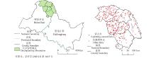
Fig.1
Spatial distribution of lightning-caused forest fires in the region of Daxing’ anling Mountains from 2010 to 2020"
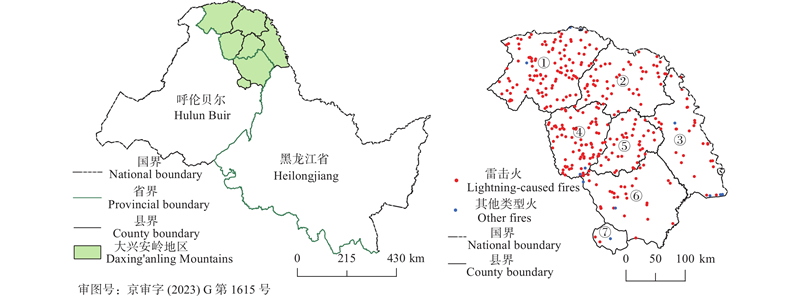
Table 1
Attribute table of lightning-caused fire risk drivers"
| 类别 Type | 风险驱动因子 Risk factor | 符号 Symbol | 单位 Unit | 时间分辨率 Temporal resolution | 空间分辨率 Spatial resolution | 数据源 Data source | 是否参与建模 Whether used in modeling |
| 闪电 Lightning | 引起雷击火的闪电总个数 Lightning-caused fire number | Frq_5 | 次times | 1 d | — | ADTD | 是Y |
| Frq_10 | 次times | 1 d | — | ADTD | 否N | ||
| 引起雷击火的闪电强度均值 Averaged lightning intensity | I_5 | kA | 1 d | — | ADTD | 是Y | |
| I_10 | kA | 1 d | — | ADTD | 否N | ||
| 引起雷击火的闪电陡度均值 Averaged lightning steep | Steep_5 | kA·μs?1 | 1 d | — | ADTD | 否N | |
| Steep_10 | kA·μs?1 | 1 d | — | ADTD | 是Y | ||
| 气象 Meteorology | 相对湿度Relative humidity | Rh | % | 1 h | 0.1° | ERA5 | 是Y |
| 总降水量 Total precipitation | Tp | m | 1 h | 0.1° | ERA5 | 是Y | |
| 气温 Temperature | Tm | K | 1 h | 0.1° | ERA5 | 是Y | |
| 气压 Air pressure | Sp | Pa | 1 h | 0.1° | ERA5 | 是Y | |
| 风速 Wind speed | Ws | m·s–1 | 1 h | 0.1° | ERA5 | 是Y | |
| 植被 Vegetation | 归一化植被指数均值 Normalized difference vegetation index | NDVI | — | 16 d | 250 m | MODIS | 是Y |
| 总初级生产力Gross primary productivity | GPP | g·m?2 | 8 d | 500 m | MODIS | 是Y | |
| 净初级生产力Net primary productivity | NPP | g·m?2 | 1 a | 1 km | MODIS | 否N | |
| 蒸散量Evapotranspiration | Et | kg·m?2 | 8 d | 0.04° | MODIS | 是Y | |
| 地形 Terrain | 高程 Elevation | Ele | m | — | 30 m | SRTM | 否N |
| 坡度 Slope | Slope | ° | — | 30 m | SRTM | 是Y | |
| 坡向 Aspect | Aspect | — | — | 30 m | SRTM | 是Y |
Table 2
Binary confusion matrix"
| 真实情况 True | 预测结果 Prediction results | |
| 反例Counter example | 正例Positive example | |
| 反例Counter example | | |
| 正例Positive example | | |
Table 3
AUC judgment classification model standard"
| AUC取值 AUC value | 模型效果 Model effect |
| [0.95,1] | 接近完美 Nearly perfect |
| [0.85,0.95] | 效果很好 Well effect |
| [0.7,0.85] | 效果一般 Common effect |
| [0.5,0.7] | 效果较差 Poor effect |
| 0.5 | 近似随机猜测 Approximate random guess |
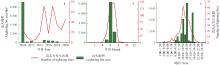
Fig.2
Temporal variation of lightning-caused fires in Daxing’ anling Mountains from 2010 to 2020(a. annual variation;b. monthly variation;c. hourly variation)"
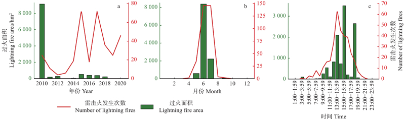
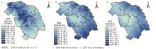
Fig.3
Spatial distribution of annual averaged lightning density (a) , intensity (b) and steepness (c) in Daxing’anling Mountains from 2010 to 2020"
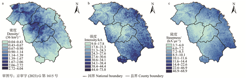
Table 4
Lighting frequency of different intensities in Daxing’ an Mountains from 2010 to 2020"
| 闪电强度 Lightning intensity/kA | 总闪次数 Total lightning frequency | 负闪次数 Negative lightning frequency | 正闪次数 Positive lightning frequency |
| 0~20 | 477 015(59.20%) | 455 961(60.52%) | 21 054(40.21%) |
| 20~40 | 224 000(27.80%) | 207 937(27.60%) | 16 063(30.68%) |
| 40~60 | 64 507(8.01%) | 56 857(7.55%) | 7 650(14.61%) |
| 60~80 | 21 546(2.67%) | 18 016(2.39%) | 3 530(6.74%) |
| >80 | 18 658(2.32%) | 14 590(1.94%) | 4 068(7.77%) |
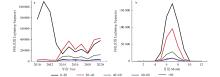
Fig.4
Year (a) and monthly (b) variation of lightning frequency with different intensities in Daxing’ anling Mountains from 2010 to 2020"
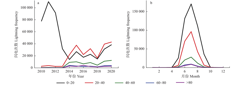
Fig.5
Number of lightning-caused fires caused by different lightning intensities (a) and steepness (b) in Daxing’ anling Mountains from 2010 to 2020"
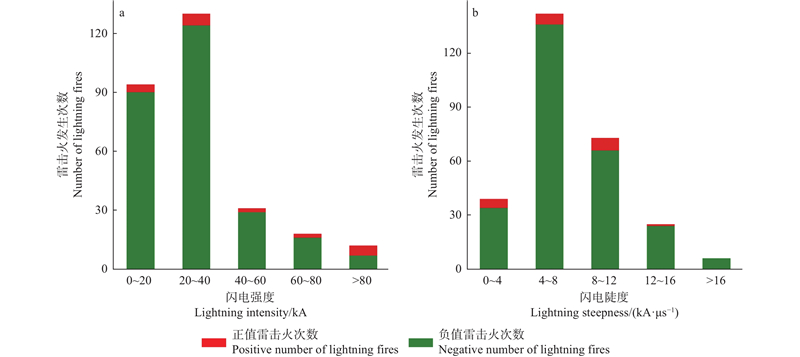
Table 5
Correlation between meteorological factors and lightning-caused fires occurrence in Daxing’ anling Mountains from 2010 to 2020"
| 指标 Index | 雷击火发生次数 Number of lightning fires | Rh | Tp | t2m | Sp | Ws | NDVI | GPP | NPP | Et |
| 雷击火发生次数 Number of lightning fires | 1 | |||||||||
| Rh | ?0.412 | 1 | ||||||||
| Tp | ?0.200 | 0.659 | 1 | |||||||
| Tm | 0.456 | ?0.319 | ?0.386 | 1 | ||||||
| Sp | 0.003 | ?0.133 | 0.022 | ?0.114 | 1 | |||||
| Ws | ?0.095 | ?0.074 | 0.299 | ?0.114 | 0.019 | 1 | ||||
| NDVI | 0.372 | 0.347 | 0.183 | 0.518 | ?0.350 | ?0.315 | 1 | |||
| GPP | 0.355 | ?0.091 | ?0.083 | 0.443 | ?0.069 | ?0.262 | 0.548 | 1 | ||
| NPP | 0.266 | ?0.052 | 0.102 | ?0.036 | ?0.048 | 0.011 | 0.134 | 0.498 | 1 | |
| Et | 0.022 | 0.270 | 0.245 | 0.339 | 0.285 | ?0.070 | 0.320 | 0.066 | ?0.107 | 1 |
Fig.6
Number of lightning-caused fires within the range of different meteorological and vegetation factors in Daxing’ anling Mountains from 2010 to 2020"
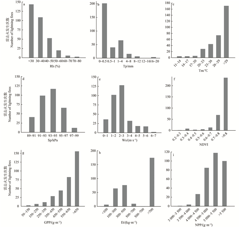
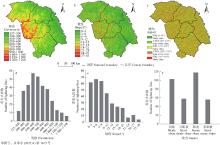
Fig.7
Spatial distribution and number of lightning-caused fires in different ranges of altitudes (a), slopes (b), aspect (c)"
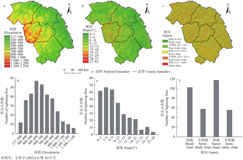
Fig.8
Feature importance comparison"
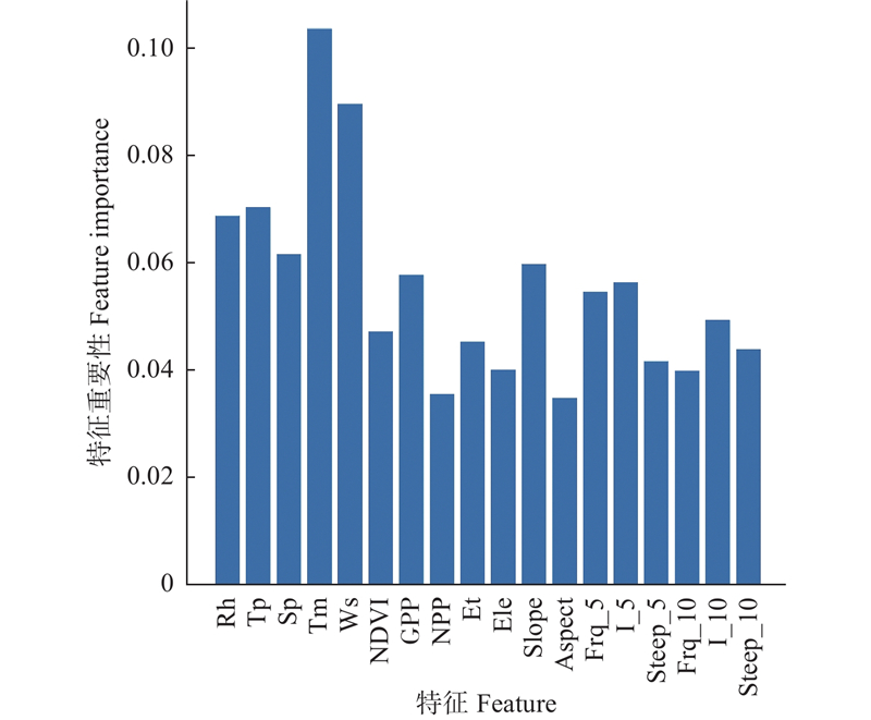
Fig.9
Feature correlation matrix"
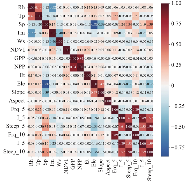
Fig.10
ROC curves of three models"
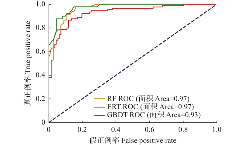
Table 6
P (precision)、R (recall) and F1 Score of three models"
| 模型Model | 目标变量 Target variable | 测试集 Testing set | ||
| P | R | F1 Score | ||
| GBDT | 0 | 0.84 | 0.91 | 0.87 |
| 1 | 0.88 | 0.79 | 0.83 | |
| RF | 0 | 0.84 | 0.95 | 0.89 |
| 1 | 0.93 | 0.78 | 0.85 | |
| ERT | 0 | 0.87 | 0.96 | 0.91 |
| 1 | 0.95 | 0.82 | 0.88 | |
Table 7
Risk classification of lightning-caused forest fire"
| 火险等级 Fire risk level | 雷击火灾发生概率 The probability of lightning-caused fire occurrence | 预报服务用语 Forecast service conditions |
| 1级(低火险) Level 1 (low fire risk) | | 雷击火险等级低 The lightning-caused fire risk level is low |
| 2级(较低火险) Level 2 (moderate low fire risk) | | 雷击火险等级较低 The lightning-caused fire risk level is relatively low |
| 3级(较高火险) Level 3 (moderate high fire risk) | | 雷击火险等级较高,须加强防范 The risk of lightning-caused fire is high and requires increased prevention measures |
| 4级(高火险) Level 4 (high fire risk) | | 雷击火险等级高,林区须加强火源管理 The risk of lightning-caused fire is high, and effective fire source management should be strengthened in forested areas |
| 5级(极高火险) Level 5 (Extremely high fire risk) | | 雷击火险等级极高,严禁 一切林内用火 The risk of lightning-caused fire is extremely high, and all forms of open flames or fires are strictly prohibited within forested areas |

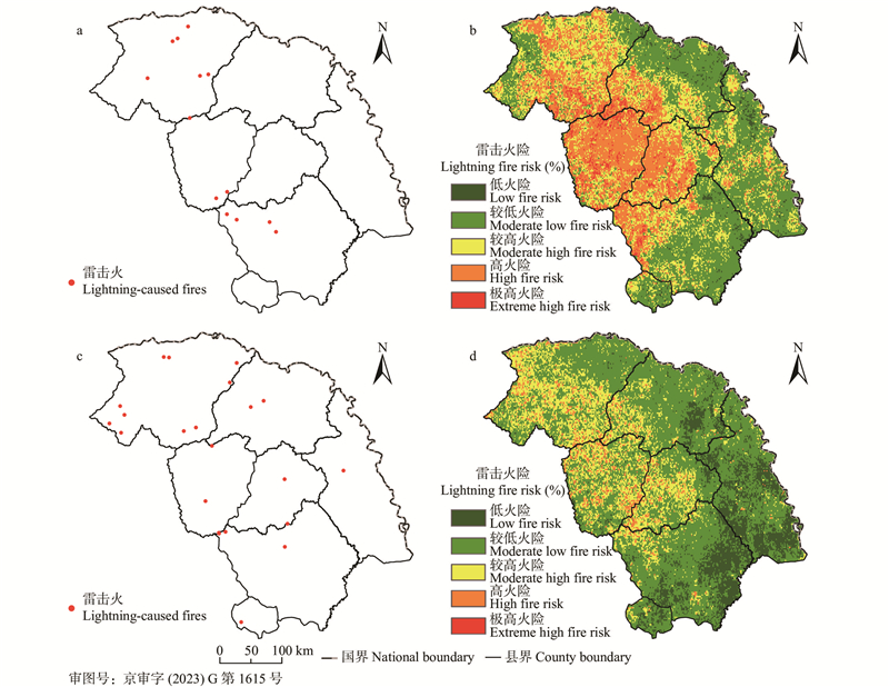
Fig.11
Spatial distribution of lightning-caused fires (a, c) and lightning fire risk (b, d) in Daxing’ anling Mountains on May 31, 2018 and July 15, 2020"
| 陈宏伟, 胡远满常, 禹 布, 等. 大兴安岭呼中林区虫害与火干扰交互作用的长期模拟. 应用生态学报, 2011, 22 (3): 585- 592. | |
| Chen H W, Hu-Yuan M C, Yu B, et al. Interaction between pest and fire disturbances in Huzhong area of Great Xing’ an Mountains: long-term simulation. Chinese Journal of Applied Ecology, 2011, 22 (3): 585- 592. | |
| 成 勤, 张科杰, 刘 俊, 等. 一次特大暴雨过程三维和二维系统闪电特征对比分析. 热带气象学报, 2021, 37 (3): 396- 408. | |
| Cheng Q, Zhang K J, Liu J, et al. Three-dimensional and two-dimensional system lightning in a torrential rain process comparative analysis of characteristics. Journal of Tropical Meteorology, 2021, 37 (3): 396- 408. | |
| 丁 鹏, 徐爱俊, 周素茵. 基于梯度提升决策树多特征结合的茶叶产量预测. 西南农业学报, 2021, 34 (7): 1556- 1563. | |
| Ding P, Xu A J, Zhou S Y. Prediction of tea yield based on gradient boosting decision tree with combining multiple features. Southwest China Journal of Agricultural Sciences, 2021, 34 (7): 1556- 1563. | |
| 杜春英, 李 帅, 刘 丹, 等. 大兴安岭地区森林雷击火发生的时空分布. 自然灾害学报, 2010, 19 (3): 72- 76. | |
| Du C Y, Li S, Liu D, et al. Temporal and spatial distribution of lightning-caused forest fires in Daxing’anling area. Journal of Natural Disasters, 2010, 19 (3): 72- 76. | |
| 高永刚, 顾 红, 张广英. 大兴安岭森林雷击火综合指标研究. 中国农学通报, 2010, 26 (6): 87- 92. | |
| Gao Y G, Gu H, Zhang G Y. Integrated index study on forest lightning fire for Daxing’anling Mountains. Chinese Agricultural Science Bulletin, 2010, 26 (6): 87- 92. | |
| 郭福涛, 胡海清, 金 森, 等. 基于负二项和零膨胀负二项回归模型的大兴安岭地区雷击火与气象因素的关系. 植物生态学报, 2010, 34 (5): 571- 577. | |
| Guo F T, Hu H Q, Jin S, et al. Relationship between forest lighting fire occurrence and weather factors in Daxing’an Mountains based on negative binomial model and zero-inflated negative binomial models. Chinese Journal of Plant Ecology, 2010, 34 (5): 571- 577. | |
| 何 诚, 舒立福, 刘柯珍. 大兴安岭地区夏季森林火灾环境因子特征分析. 西南林业大学学报(自然科学), 2021, 41 (3): 87- 93. | |
| He C, Shu L F, Liu K Z. Analysis on environmental factors’ characteristics of summer forest fire in Daxing’an Mountains. Journal of Southwest Forestry University(Natural Science), 2021, 41 (3): 87- 93. | |
| 贺 敬, 张庚辉, 王国军. 小兴安岭森林火灾发生规律及林火天气等级模型的建立. 黑龙江气象, 2011, 28 (2): 21- 22. | |
| He J, Zhang G H, Wang G J. Occurrence regularity of forest fire in Xiaoxing ' an Mountains and establishment of forest fire weather grade model. Heilongjiang Meteorology, 2011, 28 (2): 21- 22. | |
|
胡海清, 魏书精, 孙 龙. 大兴安岭2001-2010年森林火灾碳排放的计量估算. 生态学报, 2012, 32 (17): 5373- 5386.
doi: 10.5846/stxb201109091324 |
|
|
Hu H Q, Wei S J, Sun L. Estimating carbon emissions from forest fires during 2001 to 2010 in Daxing’anling Mountain. Acta Ecologica Sinica, 2012, 32 (17): 5373- 5386.
doi: 10.5846/stxb201109091324 |
|
| 刘柯珍, 赵凤君, 王明玉, 等. 基于零膨胀负二项模型对大兴安岭地区夏季火发生预报模型的研究. 林业机械与木工设备, 2018, 46 (6): 7- 11. | |
| Liu K Z, Zhao F J, Wang M Y, et al. ZINB-based research on a model for forecasting occurrence of forest fires in Daxing’anling area in summer. Forestry Machinery & Woodworking Equipment, 2018, 46 (6): 7- 11. | |
| 李 强, 史海峰. 基于ADTD与VLF/LF闪电监测系统的数据对比分析. 科技通报, 2021, 37 (11): 32- 36, 84. | |
| Li Q, Shi H F. Comparative analysis of datas based on ADTD and VLF/LF lightning location system. Bulletin of Science and Technology, 2021, 37 (11): 32- 36, 84. | |
| 马文苑, 冯仲科, 成竺欣, 等. 山西省林火驱动因子及分布格局研究. 中南林业科技大学学报, 2020, 40 (9): 57- 69. | |
| Ma W Y, Feng Z K, Cheng Z X, et al. Study on driving factors and distribution pattern of forest fires in Shanxi province. Journal of Central South University of Forestry & Technology, 2020, 40 (9): 57- 69. | |
| 倪长虹, 邸雪颖. 黑龙江省大兴安岭雷击火发生规律. 东北林业大学学报, 2009, 37 (1): 55- 57,75. | |
| Ni C H, Di X Y. Occurrence regularity of lightning fire in Daxing’anling, Heilongjiang. Journal of Northeast Forestry University, 2009, 37 (1): 55- 57,75. | |
| 彭 欢, 史明昌, 孙 瑜, 等. 基于Logistic的大兴安岭雷击火预测模型. 东北林业大学学报, 2014, 42 (7): 166- 169. | |
| Peng H, Shi C M, Sun Y, et al. Lightning fire forecasting model of Daxing’an Mountain based on logistic model. Journal of Northeast Forestry University, 2014, 42 (7): 166- 169. | |
| 舒立福, 田晓瑞, 李 骞, 等. 雷击火形成及预防扑救对策. 火灾科学, 2014, 8 (3): 31- 37. | |
| Shu L F, Tian X R, Li Q, et al. 1999. The formation of lightning fire and its prevention countermeasures. Fire Safety Science, 2014, 8 (3): 31- 37. | |
| 舒 洋, 孙子瑜, 张 恒. 世界森林雷击火研究现状和展望. 世界林业研究, 2022, 35 (2): 34- 40. | |
| Shu Y, Sun Z Y, Zhang H. Current status and prospects of research on lightning strike in forest fire. World Forestry Research, 2022, 35 (2): 34- 40. | |
| 苏漳文. 2020. 基于地理信息系统的大兴安岭林火发生驱动因子及预测模型的研究. 哈尔滨: 东北林业大学. | |
| (Su Z W. 2020. Study on driving factors and forecasting models of forest fire in the Xing’an Mountains based on geographic information system. Harbin: Northeast Forestry University.[in Chinese]). | |
| 孙 瑜, 史明昌, 彭 欢, 等. 基于MAXENT模型的黑龙江大兴安岭森林雷击火火险预测. 应用生态学报, 2014, 25 (04): 1100- 1106. | |
| Sun Y, Shi M C, Peng H, et al. Forest lighting fire forecasting for Daxing’anling Mountains based on MAXENT model. Chinese Journal of Applied Ecology, 2014, 25 (04): 1100- 1106. | |
| 田晓瑞, 舒立福, 赵凤君, 等. 大兴安岭雷击火发生条件分析. 林业科学, 2012, 48 (7): 98- 103. | |
| Tian X R, Shu L F, Zhao F J, et al. Analysis of the conditions for lightning fire occurrence in Daxing' anling region. Scientia Silvae Sinicae, 2012, 48 (7): 98- 103. | |
| 王会福, 龚立群. 秦岭林区雷击火的发生和预防. 陕西林业科技, 2013, 72 (5): 69- 70. | |
| Wang H F, Gong L Q. Occurrence and prevention of lightning fire in Qinling forest region. Shanxi Forest Science and Technology, 2013, 72 (5): 69- 70. | |
| 王晓红, 黄 艳, 张吉利, 等. 基于闪电定位数据和气象数据的大兴安岭雷击火预测模型研究. 中南林业科技大学学报, 2017, 37 (3): 44- 48. | |
| Wang X H, Huang Y, Zhang J L, et al. Research on daily prediction model of lightning fires in Daxing’an ling region based on lightning location data. Journal of Central South University of Forestry & Technology, 2017, 37 (3): 44- 48. | |
| 韦良芳. 2020. 基于极端随机树与Logistic回归算法的网贷平台个人信用评估模型的比较研究. 济南: 山东大学. | |
| (Wei L F. 2020. A comparative study of personal credit evaluation model on net lending platforms based on extremely randomized trees with logistic regression algorithm. Jinan: Shandong University.[in Chinese]). | |
| 于建龙, 刘乃安. 我国大兴安岭地区森林雷击火发生的火险天气等级研究. 火灾科学, 2010, 19 (3): 131- 137. | |
| Yu J L, Liu N A. Study on the fire dangerous weather level of forest thunder fire in Daxing’an Mountains of China. Fire Safety Science, 2010, 19 (3): 131- 137. | |
| 臧桐汝, 舒立福, 王明玉, 等. 黑龙江大兴安岭林区雷击火时空分布及驱动因素分析. 西北农林科技大学学报(自然科学版), 2022, 50 (12): 2- 14. | |
| Zang T R, Shu L F, Wang M Y, et al. Analysis of spatial and temporal distribution and driving factors of lightning-caused fires in Daxing’anling forest region of Heilongjiang. Journal of Northwest A & F University(Natural Science Edition), 2022, 50 (12): 2- 14. | |
| 张吉利, 毕 武, 王晓红, 等. 雷击火发生的影响因子与预测研究进展. 应用生态学报, 2013, 24 (9): 2674- 2684. | |
| Zhang J L, Bi W, Wang X H, et al. Lightning-caused fire, its affecting factors and prediction: A review. Chinese Journal of Applied Ecology, 2013, 24 (9): 2674- 2684. | |
| 张 媛, 李胜男, 张运生. 森林雷击火特点和监测预警技术研究进展. 森林防火, 2018, 36 (3): 44- 48. | |
| Zhang Y, Li S N, Zhang Y S. Research progress of forest thunder fire characteristics and monitoring and early warning technology. Forest Fire Prevention, 2018, 36 (3): 44- 48. | |
| 赵鲁强, 杨晓丹, 梁 莉, 等. 2018. GB/T 36743—2018森林火险气象等级. 北京: 中国标准出版社. | |
| Zhao L Q, Yang X D, Liang L, et al. 2018. GB/T 36743—2018 Forest fire danger weather ratings. Beijing: Standards Press of China.[in Chinese] | |
|
Albert-Green A, Dean C B, Martell D L, et al. A methodology for investigating trends in changes in the timing of the fire season with applications to lightning-caused forest fires in Alberta and Ontario, Canada. Canadian Journal of Forest Research-revue Canadienne De Recherche Forestiere, 2013, 43 (1): 39- 45.
doi: 10.1139/cjfr-2011-0432 |
|
|
Barbero R, Abatzoglou J T, Kolden C A, et al. Multi-scalar influence of weather and climate on very large-fires in the Eastern United States. International Journal of Climatology, 2015, 35 (8): 2180- 2186.
doi: 10.1002/joc.4090 |
|
| Chen F, Du Y, Niu S, et al. Modeling forest lightning fire occurrence in the Daxinganling Mountains of northeastern China with MAXENT. Forests, 2015, 6 (5): 1422- 1438. | |
| Dickson B G. , Prather J W, Xu Y, et al. 2006. Mapping the probability of large fire occurrence in northern Arizona, USA. Landscape Ecology. 21(5): 747-761. | |
|
Friedman J H. Greedy function approximation: a gradient Boosting machine. Annals of Statistics, 2001, 29 (5): 1189- 1232.
doi: 10.1214/aos/1013203450 |
|
|
Geurts P, Ernst D, Wehenkel L. Extremely randomized trees. Machine Learning, 2006, 63 (1): 3- 42.
doi: 10.1007/s10994-006-6226-1 |
|
|
Guo F, Wang G, Su Z, et al. What drives forest fire in Fujian, China? Evidence from logistic regression and random forests. International Journal of Wildland Fire, 2016, 25 (5): 505.
doi: 10.1071/WF15121 |
|
|
Krenn R, Hergarten S. Cellular automaton modelling of lightning-induced and man made forest fires. Natural Hazards Earth System Sciences, 2009, 9 (5): 1743- 1748.
doi: 10.5194/nhess-9-1743-2009 |
|
| Miyoshi S, Uezu T, Okada M. Statistical mechanics of time domain ensemble learning. Journal of the Physical Society of Japan, 2006, 75 (8): 2652- 2674. | |
|
Pew K L, Larsen C P S. GIS analysis of spatial and temporal patterns of human-caused wildfires in the temperate rain forest of Vancouver Island, Canada. Forest ecology and management, 2001, 140 (1): 1- 18.
doi: 10.1016/S0378-1127(00)00271-1 |
|
| Scornet E. Random forests and kernel methods. IEEE Transactions on Information Theory, 2015, 62 (3): 1485- 1500. | |
| Shevyrnogov A P, Botvich I Y, Kononova N A, et al. Remote ground-based and satellite monitoring of vegetation. Herald of the Russian Academy of Sciences, 2019, 88 (6): 469- 474. | |
|
Wang S, Li H L, Niu S K. Empirical research on climate warming risks for forest fires: A case study of grade I forest fire danger zone, Sichuan province, China. Sustainability, 2021, 13 (14): 7773.
doi: 10.3390/su13147773 |
|
| Wu Z W, He H S, Yang J, et al. Relative effects of climatic and local factors on fire occurrence in boreal forest landscapes of northeastern China. Science of the Total Environment, 2014, 493 (5): 472- 480. | |
|
Zhang Y G, Ju W M, Migliavacca M, et al. Advances in hyperspectral remote sensing of vegetation traits and functions. Remote Sensing of Environment, 2021, 252, 112121.
doi: 10.1016/j.rse.2020.112121 |
| [1] | Xiaocheng Zhou, Tingting Huang, Yuan Li, Xiangxi Xiao, Hongru Zhu, Yunzhi Chen, Zhiqing Feng. A Method for Estimating Subtropical Forest Stock by Combining Remotely Sensed Forest Age Factors [J]. Scientia Silvae Sinicae, 2023, 59(4): 88-99. |
| [2] | Bingxiang Tan,Mingtan Shen,Guangfa Qie,Zhao Qi,Chenrui He. Temporal and Spatial Changes Monitoring of Vegetation Coverage for the Ecological Core Area of Chongli Winter Olympic Games [J]. Scientia Silvae Sinicae, 2022, 58(4): 141-151. |
| [3] | Nannan Yang,Yan Bai,Suyi Jiang,Chunmei Yang,Kaihong Xu. Recognition Method of Plate and Wood Based on ALexNet Optimaization [J]. Scientia Silvae Sinicae, 2022, 58(3): 149-158. |
| [4] | Liqing Si,Shangbo Yuan,Fengjun Zhao,Lifu Shu,Mingyu Wang,Qiming Ma. Relationship between Lightning, Lightning Fire and Human Activities [J]. Scientia Silvae Sinicae, 2022, 58(11): 1-9. |
| [5] | Mingyu Wang,Shangbo Yuan,Wei Li,Weike Li,Jiajun Song,Liqing Si,Yahui Wang,Fengjun Zhao,Xiaorui Tian,Xiaoxiao Li,Lifu Shu. Process and Influencing Factors of Mass Lightning Fires Caused by Dense Lightning in Daxing'anling Mountains [J]. Scientia Silvae Sinicae, 2022, 58(11): 10-20. |
| [6] | Weike Li,Lifu Shu,Shangbo Yuan,Jiajun Song,Wei Li,Liqing Si,Fengjun Zhao,Yahui Wang,Mingyu Wang. Temporal and Spatial Distribution Characteristics of Lightning in Daxing'anling Mountains Based on VLF/LF 3D Lightning Location System [J]. Scientia Silvae Sinicae, 2022, 58(11): 21-30. |
| [7] | Jia Li,Lan Lan,Zuozhong Zhang,Wentao Yuan,Demin Gao,Shuqin Zong,Qiaolin Ye. Inversion Technology of Forest Fuel Moisture Content Based on Deep Learning [J]. Scientia Silvae Sinicae, 2022, 58(10): 47-58. |
| [8] | Xiaocheng Zhou,Lei Zheng,Hongyu Huang. Classification of Forest Stand Based on Multi-Feature Optimization of UAV Visible Light Remote Sensing [J]. Scientia Silvae Sinicae, 2021, 57(6): 24-36. |
| [9] | Ying Pan,Mingming Ding,Jie Lin,Qiao Dai,Geng Guo,Linlin Cui. Inversion of Forest Leaf Area Index Based on PROSAIL Model and Multi-Angle Remote Sensing Data [J]. Scientia Silvae Sinicae, 2021, 57(4): 90-106. |
| [10] | Huiru Zhang,Xiangdong Lei,Fengri Li. Research Progress and Prospects of Forest Management Science in China [J]. Scientia Silvae Sinicae, 2020, 56(9): 130-142. |
| [11] | Jinying Xie,Lixia Ding,Zhihui Wang,Lijuan Liu. Classification of Coastal Wetland Vegetation Utilizing FCN and Object-Oriented Methods [J]. Scientia Silvae Sinicae, 2020, 56(8): 98-106. |
| [12] | Lin Zhao,Xiaoli Zhang,Yanshuang Wu,Bin Zhang. Subtropical Forest Tree Species Classification Based on 3D-CNN for Airborne Hyperspectral Data [J]. Scientia Silvae Sinicae, 2020, 56(11): 97-107. |
| [13] | Du Yichen, Li Mingze, Fan Wenyi, Wang Bin. Estimation of Forest Stand Age Based on GWR Model and Forest Fire Remote Sensing Data [J]. Scientia Silvae Sinicae, 2019, 55(6): 184-194. |
| [14] | Li Niwen, Zhang Xiaoli, Zhang Ning, Zhu Chenghao, Sun Zhenfeng. Hazards Evaluation of Dendrolimus tabulaeformis (Lepidoptera: Lasiocampidae) Based on Weighted Information Value Model [J]. Scientia Silvae Sinicae, 2019, 55(3): 106-117. |
| [15] | Liu Luxia, Pang Yong, Ren Haibao, Li Zengyuan. Predict Tree Species Diversity from GF-2 Satellite Data in a Subtropical Forest of China [J]. Scientia Silvae Sinicae, 2019, 55(2): 61-74. |
| Viewed | ||||||
|
Full text |
|
|||||
|
Abstract |
|
|||||