
Scientia Silvae Sinicae ›› 2021, Vol. 57 ›› Issue (6): 24-36.doi: 10.11707/j.1001-7488.20210603
Previous Articles Next Articles
Xiaocheng Zhou,Lei Zheng,Hongyu Huang
Received:2019-09-11
Online:2021-06-25
Published:2021-08-06
CLC Number:
Xiaocheng Zhou,Lei Zheng,Hongyu Huang. Classification of Forest Stand Based on Multi-Feature Optimization of UAV Visible Light Remote Sensing[J]. Scientia Silvae Sinicae, 2021, 57(6): 24-36.

Fig.1
Location of the study area and distribution of samples"

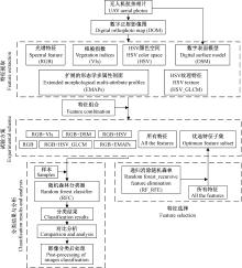
Fig.2
Technical flowchart"

Table 1
Vegetation indices(VIs) derived from visible bands"
| 植被指数Vegetation indices(VIs) | 公式Formulation | 参考文献Reference |
| 归一化绿红差分指数 Normalized green-red difference index(NGRDI) | NGRDI=(G-R)/(G+R) | |
| 超绿指数Excess green index(EXG) | EXG=2g-r-b | |
| 植被颜色指数Color index of vegetation(CIVE) | CIVE=0.441r-0.881g+0.385b+18.787 45 | |
| 植被指数Vegetation index(VEG) | VEG=g/rab(1-a), a=0.667 | |
| 超绿超红差分指数 Excess green minus excess red index(EXGR) | EXGR=EXG-1.4r-g | |
| Woebbecke指数Woebbecke index(WI) | WI=(g-b)/(r-g) | |
| 联合指数Combination index(COM) | COM=0.25EXG+0.3EXGR+0.33CIVE+0.12VEG | |
| 联合指数2 Combination index 2(COM2) | COM2=0.36EXG+0.47CIVE+0.17VEG |
Table 2
The information of experimental programs"
| 试验Experiment | 特征Features |
| 1 | 光谱特征RGB |
| 2 | 光谱特征+DSM RGB+DSM |
| 3 | 光谱特征+植被指数RGB+VIs |
| 4 | 光谱特征+HSV RGB+HSV |
| 5 | 光谱特征+HSV纹理特征RGB+HSV_GLCM |
| 6 | 光谱特征+EMAPs RGB+EMAPs |
| 7 | 所有特征All features |
| 8 | 优化特征子集Optimized feature subset |
Table 3
DSM precision"
| 实测高度 Measured height/m | DSM/m | 误差Error/m |
| 290.019 | 289.957 | 0.062 |
| 293.550 | 293.540 | 0.010 |
| 293.385 | 293.333 | 0.050 |
| 290.029 | 289.957 | 0.072 |
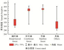
Fig.3
Height distribution of forest stand samples"
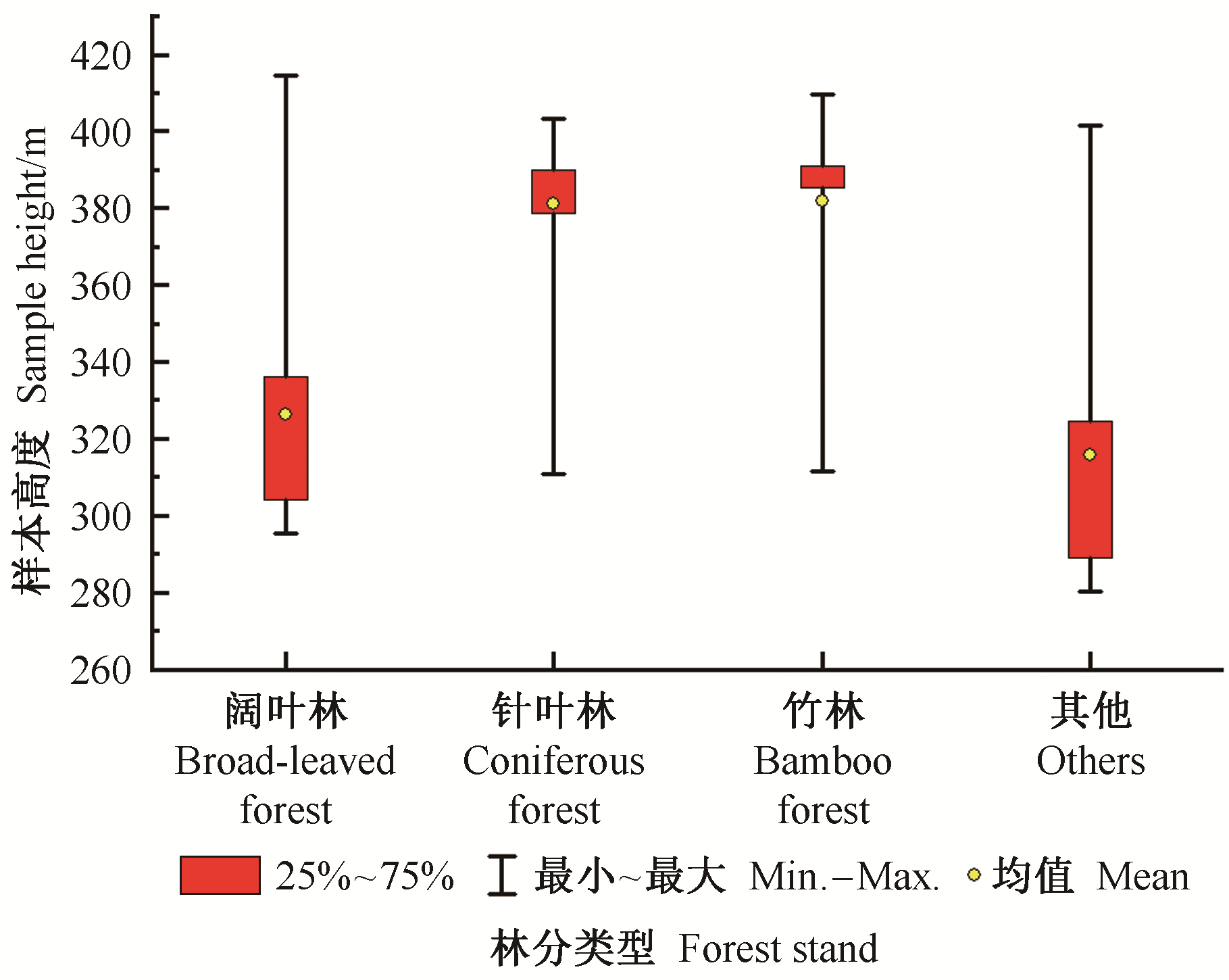
Fig.4
Mean vegetation index of each forest stand samples"
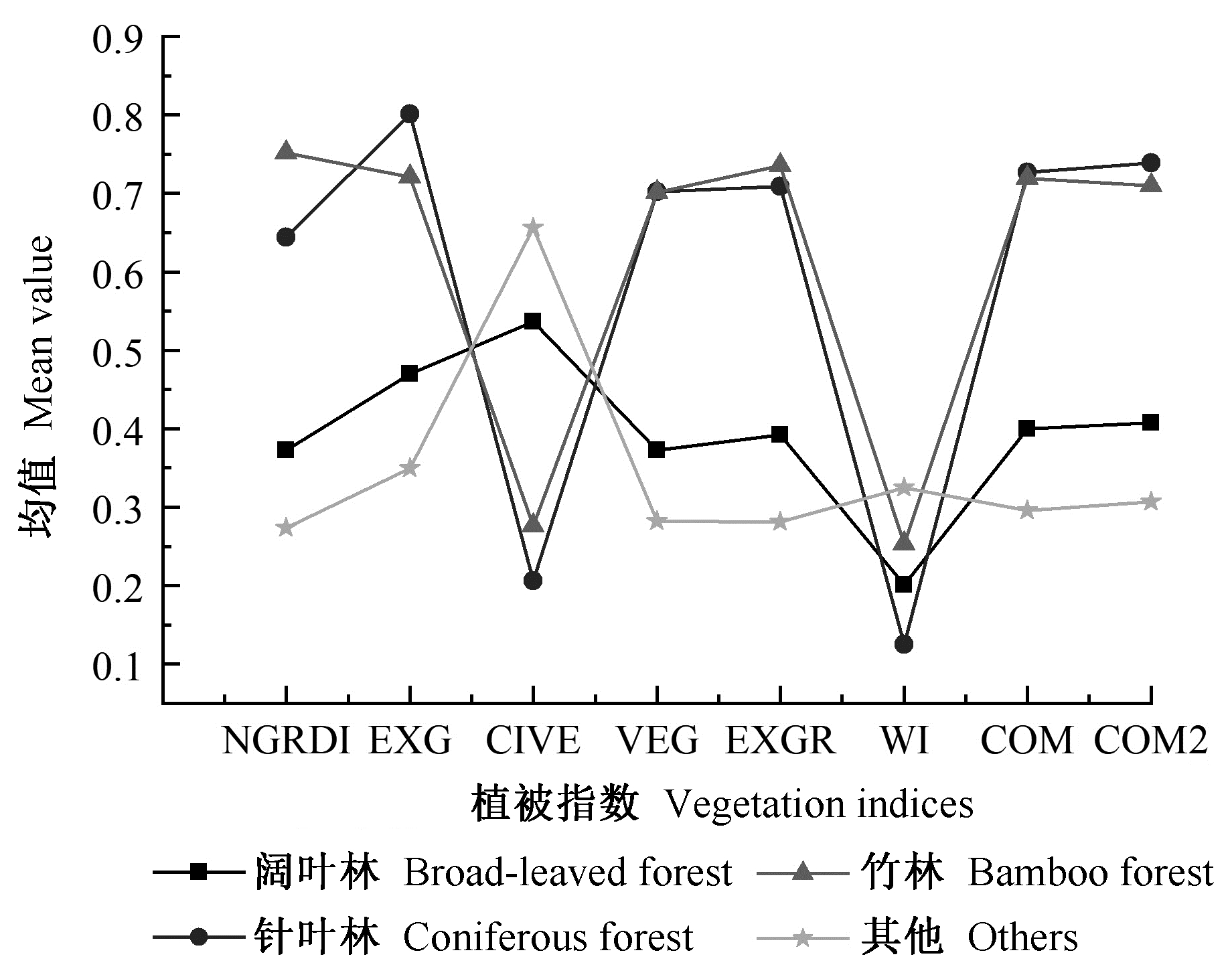
Fig.5
Mean separability of samples"

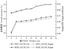
Fig.6
Comparison of classification accuracy between HSV texture and RGB texture under different window sizes"


Fig.7
Feature selection using random forest_recursive feature elimination(RF_RFE)"
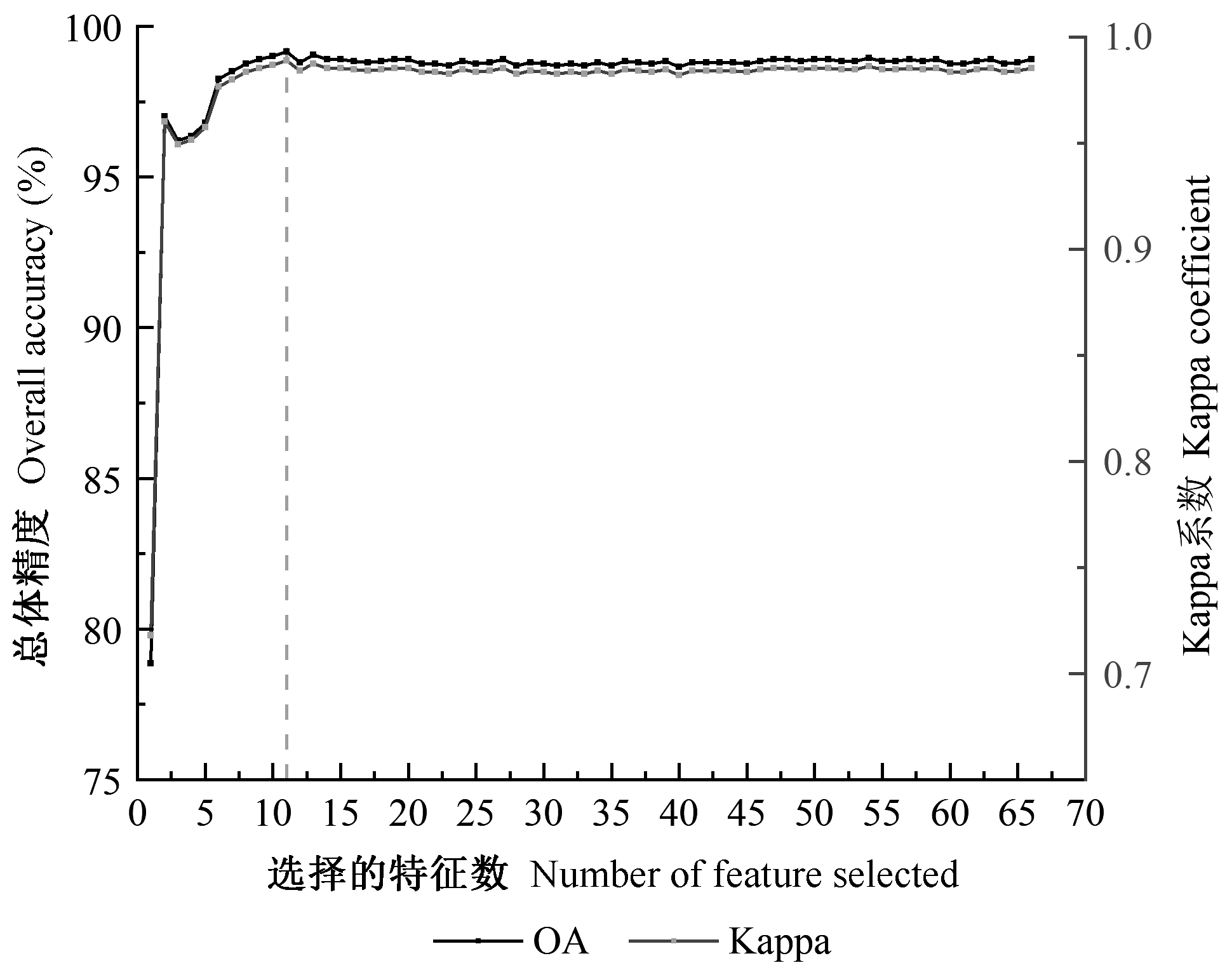
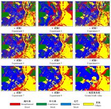
Fig.8
Classification results of different experiments"

Table 4
The statistics of classification accuracy"
| 试验 Experiment | 精度 Accuracy | 阔叶林 Broad-leaved forest | 针叶林 Coniferous forest | 竹林 Bamboo forest | 其他 Others | 总体精度 OA(%) | Kappa系数 Kappa coefficient |
| 1 | PA(%) | 62.76 | 67.48 | 77.22 | 60.60 | 65.68 | 0.53 |
| UA(%) | 47.04 | 74.59 | 54.44 | 76.85 | |||
| F(%) | 53.77 | 70.86 | 63.86 | 67.86 | |||
| 2 | PA(%) | 71.37 | 62.82 | 56.07 | 77.61 | 66.40 | 0.54 |
| UA(%) | 44.74 | 43.13 | 79.04 | 88.42 | |||
| F(%) | 55.00 | 51.18 | 65.60 | 82.66 | |||
| 3 | PA(%) | 60.83 | 76.74 | 64.91 | 64.32 | 65.52 | 0.52 |
| UA(%) | 46.77 | 56.13 | 75.18 | 73.60 | |||
| F(%) | 52.88 | 64.84 | 69.67 | 68.65 | |||
| 4 | PA(%) | 61.61 | 76.91 | 66.91 | 63.58 | 66.21 | 0.53 |
| UA(%) | 47.82 | 55.86 | 75.09 | 75.40 | |||
| F(%) | 53.85 | 64.72 | 70.76 | 68.99 | |||
| 5 | PA(%) | 53.98 | 75.20 | 81.37 | 78.29 | 75.17 | 0.65 |
| UA(%) | 66.36 | 62.72 | 76.81 | 82.74 | |||
| F(%) | 59.53 | 68.40 | 79.02 | 80.45 | |||
| 6 | PA(%) | 65.55 | 80.29 | 78.37 | 76.49 | 75.92 | 0.66 |
| UA(%) | 61.21 | 61.20 | 81.23 | 86.14 | |||
| F(%) | 63.21 | 69.48 | 79.77 | 81.03 | |||
| 7 | PA(%) | 67.87 | 79.89 | 82.61 | 84.72 | 80.57 | 0.72 |
| UA(%) | 70.83 | 70.24 | 83.09 | 86.86 | |||
| F(%) | 69.32 | 74.75 | 82.85 | 85.78 | |||
| 8 | PA(%) | 69.20 | 73.02 | 83.26 | 87.36 | 81.05 | 0.73 |
| UA(%) | 70.13 | 72.99 | 85.11 | 84.63 | |||
| F(%) | 69.66 | 73.00 | 84.17 | 85.97 |
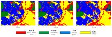
Fig.9
Classification results of different resolution image"

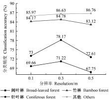
Fig.10
The classification accuracy of each forest stand type in different resolution image"

| 鲍蕊, 夏俊士, 薛朝辉, 等. 基于形态学属性剖面的高光谱影像集成分类. 遥感技术与应用, 2016, 31 (4): 731- 738. | |
| Bao R , Xia J S , Xue Z H , et al. Ensemble classification for hyperspectral imagery based on morphological attribute profiles. Remote Sensing Technology and Application, 2016, 31 (4): 731- 738. | |
|
戴建国, 张国顺, 郭鹏, 等. 基于无人机遥感可见光影像的北疆主要农作物分类方法. 农业工程学报, 2018, 34 (18): 122- 129.
doi: 10.11975/j.issn.1002-6819.2018.18.015 |
|
|
Dai J G , Zhang G S , Guo P , et al. Classification method of main crops in northern Xinjiang based on UAV visible waveband images. Transactions of the Chinese Society of Agricultural Engineering, 2018, 34 (18): 122- 129.
doi: 10.11975/j.issn.1002-6819.2018.18.015 |
|
| 范承啸, 韩俊, 熊志军, 等. 无人机遥感技术现状与应用. 测绘科学, 2009, 34 (5): 214- 215. | |
| Fan C X , Han J , Xiong Z J , et al. Application and status of unmanned aerial vehicle remote sensing technology. Science of Surveying and Mapping, 2009, 34 (5): 214- 215. | |
| 郭玉宝, 池天河, 彭玲, 等. 利用随机森林的高分一号遥感数据进行城市用地分类. 测绘通报, 2016, (5): 73- 76. | |
| Guo Y B , Chi T H , Peng L , et al. Classification of GF-1 remote sensing image based on random forests for urban land-use. Bulletin of Surveying and Mapping, 2016, (5): 73- 76. | |
| 井然, 邓磊, 赵文吉, 等. 基于可见光植被指数的面向对象湿地水生植被提取方法. 应用生态学报, 2016, 27 (5): 1427- 1436. | |
| Jing R , Deng L , Zhao W J , et al. Object-oriented aquatic vegetation extracting approach based on visible vegetation indices. Chinese Journal of Applied Ecology, 2016, 27 (5): 1427- 1436. | |
| 林志玮, 丁启禄, 黄嘉航, 等. 基于DenseNet的无人机光学图像树种分类研究. 遥感技术与应用, 2019, 34 (4): 704- 711. | |
| Lin Z W , Ding Q L , Huang J H , et al. Study on tree species classification of UAV optical image based on DenseNet. Remote Sensing Technology and Application, 2019, 34 (4): 704- 711. | |
| 刘友山, 吕成文, 祝凤霞, 等. 基于PCA和多尺度纹理特征提取的高分辨率遥感影像分类. 遥感技术与应用, 2012, 27 (5): 706- 711. | |
| Liu Y S , Lü C W , Zhu F X , et al. Extraction of high spatial resolution remote sensing image classification based on PCA and multi-scale texture feature. Remote Sensing Techology and Application, 2012, 27 (5): 706- 711. | |
|
刘云鹏, 巩睿, 解春霞, 等. 基于Landsat遥感影像的杨树信息提取方法分析. 江苏林业科技, 2017, 44 (2): 28- 33.
doi: 10.3969/j.issn.1001-7380.2017.02.007 |
|
|
Liu Y P , Gong R , Xie C X , et al. Study on information extraction of poplar resources using landsat remotely sensed datasets. Journal of Jiangsu Forestry Science & Technology, 2017, 44 (2): 28- 33.
doi: 10.3969/j.issn.1001-7380.2017.02.007 |
|
|
吕杰, 郝宁燕, 李崇贵, 等. 利用随机森林和纹理特征的森林类型识别. 遥感信息, 2017, 32 (6): 109- 114.
doi: 10.3969/j.issn.1000-3177.2017.06.018 |
|
|
Lü J , Hao N Y , Li C G , et al. Identification of forest type based on random forest and texture characteristics. Remote Sensing Information, 2017, 32 (6): 109- 114.
doi: 10.3969/j.issn.1000-3177.2017.06.018 |
|
| 马慧娟, 高小红, 谷晓天. 随机森林方法支持的复杂地形区土地利用/土地覆被分类研究. 地球信息科学学报, 2019, 21 (3): 359- 371. | |
| Ma H J , Gao X H , Gu X T . Random forest classification of Landsat 8 imagery for the complex terrain area based on the combination of spectral, topographic and texture information. Journal of Geo-Information Science, 2019, 21 (3): 359- 371. | |
| 马娜, 胡云锋, 庄大方, 等. 基于最佳波段指数和J-M距离可分性的高光谱数据最佳波段组合选取研究——以环境小卫星高光谱数据在东莞市的应用为例. 遥感技术与应用, 2010, 25 (3): 358- 365. | |
| Ma N , Hu Y F , Zhuang D F , et al. Determination on the optimum band combination of HJ-1A hyperspectral data in the case region of Dongguan based on optimum index factor and J-M distance. Remote Sensing Technology and Application, 2010, 25 (3): 358- 365. | |
| 裴欢, 孙天娇, 王晓妍. 基于Landsat 8 Oli影像纹理特征的面向对象土地利用/覆盖分类. 农业工程学报, 2018, 34 (2): 248- 255. | |
| Pei H , Sun T J , Wang X Y . Object-oriented land use/cover classification based on texture features of Landsat 8 Oli image. Transactions of the Chinese Society of Agricultural Engineering, 2018, 34 (2): 248- 255. | |
| 任芯雨. 2016. 考虑植被季相节律的高分辨率遥感影像城市森林分类. 南京: 南京林业大学硕士学位论文. | |
| Ren X Y. 2016. Urban forest vegetation classification in consideration of vegetation phenolpgy based on high spatial resolution on satellite imagery. Nanjing: MS thesis of Nanjing Forestry University. [in Chinese] | |
| 史忠奎, 李培军, 罗伦, 等. 基于形态学属性剖面和单类随机森林分类的道路路域新增建筑物提取方法. 北京大学学报: 自然科学版, 2018, 54 (1): 105- 114. | |
| Shi Z K , Li P J , Luo L , et al. A method for extraction of newly-built buildings in road region using morphological attribute profiles and one-class random forest. Acta Scientiarum Naturalium Universitatis Pekinensis, 2018, 54 (1): 105- 114. | |
| 宋荣杰, 宁纪锋, 常庆瑞, 等. 基于小波纹理和随机森林的猕猴桃果园遥感提取. 农业机械学报, 2018, 49 (4): 222- 231. | |
| Song R J , Ning J F , Chang Q R , et al. Kiwifruit orchard mapping based on wavelet textures and random forest. Transactions of the Chinese Society of Agricultural Machinery, 2018, 49 (4): 222- 231. | |
| 宋荣杰, 宁纪锋, 刘秀英, 等. 基于纹理特征和SVM的QuickBird影像苹果园提取. 农业机械学报, 2017, 48 (3): 188- 197. | |
| Song R J , Nimg J F , Liu X Y , et al. Apple orchard extraction with QuickBird imagery based on texture features and support vector machine. Transactions of the Chinese Society of Agricultural Machinery, 2017, 48 (3): 188- 197. | |
| 王娜, 李强子, 杜鑫, 等. 单变量特征选择的苏北地区主要农作物遥感识别. 遥感学报, 2017, 21 (4): 519- 530. | |
| Wang N , Li Q Z , Du X , et al. Identification of main crops based on the univariate feature selection in Subei. Journal of Remote Sensing, 2017, 21 (4): 519- 530. | |
|
温小乐, 钟奥, 胡秀娟. 基于随机森林特征选择的城市绿化乔木树种分类. 地球信息科学学报, 2018, 20 (12): 1777- 1786.
doi: 10.12082/dqxxkx.2018.180310 |
|
|
Wen X L , Zhong A , Hu X J . The classification of urban greening tree species based on feature selection of random. Journal of Geo-Information Science, 2018, 20 (12): 1777- 1786.
doi: 10.12082/dqxxkx.2018.180310 |
|
| 杨珺雯, 张锦水, 朱秀芳, 等. 随机森林在高光谱遥感数据中降维与分类的应用. 北京师范大学学报: 自然科学版, 2015, 51 (S1): 82- 88. | |
| Yang J W , Zhang J S , Zhu X F , et al. Random forest applied for dimension reduction and classification in hyperspectral data. Journal of Beijing Normal University: Natural Science, 2015, 51 (S1): 82- 88. | |
| 尹凌宇, 覃先林, 孙桂芬, 等. 基于高分二号多光谱数据的树种识别方法. 林业资源管理, 2016, (4): 121- 127. | |
| Yin L Y , Qin X L , Sun G F , et al. Tree species identification method based on GF-2 images. Forest Resources Management, 2016, (4): 121- 127. | |
| 张磊, 宫兆宁, 王启为, 等. Sentinel-2影像多特征优选的黄河三角洲湿地信息提取. 遥感学报, 2019, 23 (2): 313- 326. | |
| Zhang L , Gong Z N , Wang Q W , et al. Wetland mapping of yellow river delta wetlands based on multi-feature optimization of Sentinel-2 images. Journal of Remote Sensing, 2019, 23 (2): 313- 326. | |
|
Brovkina O , Cienciala E , Surový P , et al. Unmanned aerial vehicles (UAV) for assessment of qualitative classification of Norway spruce in temperate forest stands. Geo-Spatial Information Science, 2018, 21 (1): 12- 20.
doi: 10.1080/10095020.2017.1416994 |
|
|
Cheng K , Wang J . Forest type classification based on integrated spectral-spatial-temporal features and random forest algorithm-a case study in the Qinling Mountains. Forests, 2019, 10 (7): 559- 577.
doi: 10.3390/f10070559 |
|
|
Cross M , Scambos T , Pacifici F , et al. Classification of tropical forest tree species using meter-scale image data. Remote Sensing, 2019, 11 (12): 1411- 1159.
doi: 10.3390/rs11121411 |
|
| Mura M D , Benediktsson J A , Waske B , et al. Morphological attribute profiles for the analysis of very high resolution images. IEEE Transactions on Geoscience and Remote Sensing, 2010, 48 (10): 3747- 3762. | |
| David L C G, Ballado A H. 2016. Vegetation indices and textures in object-based weed detection from UAV imagery. Proceedings of the 6th IEEE International Conference on Control System, Computing and Engineering, Penang, Malaysia. | |
| Fassnacht F E , Latifi H , Stereńczak K , et al. Review of studies on tree species classification from remotely sensed data. Remote Sensing of Environment, 2016, 186 (214): 64- 87. | |
| Ghamisi P , Benediktsson J A , Cavallaro G , et al. Automatic framework for spectral-spatial classification based on supervised feature extraction and morphological attribute profiles. IEEE Journal of Selected Topics in Applied Earth Observations and Remote Sensing, 2014, 7 (6): 2147- 2160. | |
| Gini R , Sona G , Ronchetti G , et al. Improving tree species classification using UAS multispectral images and texture measures. ISPRS International Journal of Geo-Information, 2018, 7 (8): 315- 333. | |
| Gini R , Passoni R , Pinto L , et al. Use of unmanned aerial systems for multispectral survey and tree classification: a test in a park area of northern Italy. European Journal of Remote Sensing, 2014, 47 (1): 251- 269. | |
| Gitelson A A , Kaufman Y J , Stark R , et al. Novel algorithms for remote estimation of vegetation fraction. Remote Sensing of Environment, 2002, 80 (1): 76- 87. | |
| Guerrero J M , Pajares G , Montalvo M , et al. Support vector machines for crop/weeds identification in maize fields. Expert Systems with Applications, 2012, 39 (12): 11149- 11155. | |
| Guijarro M , Pajares G , Riomoros I , et al. Automatic segmentation of relevant textures in agricultural images. Computers and Electronics in Agriculture, 2011, 75 (1): 75- 83. | |
| Hague T , Tillett N D , Wheeler H . Automated crop and weed monitoring in widely spaced cereals. Precision Agriculture, 2006, 7 (1): 21- 32. | |
| Haralick R M, Shanmugam K, Dinstein I. 1973. Textural features for image classification. IEEE Transactions on Systems, Man & Cybernetics, SMC-3(6): 610-621. | |
| Kataoka T, Kaneko T, Okamoto H, et al. 2003. Crop growth estimation system using machine vision. IEEE/ASME International Conference on Advanced Intelligent Mechatronics. | |
| Marpu P R , Pedergnana M , Mura M D , et al. Automatic generation of standard deviation attribute profiles for spectral-spatial classification of remote sensing data. IEEE Geoscience and Remote Sensing Letters, 2013, 10 (2): 293- 297. | |
| Maschler J , Atzberger C , Immitzer M . Individual tree crown segmentation and classification of 13 tree species using airborne hyperspectral data. Remote Sensing, 2018, 10 (8): 1218- 1247. | |
| Michez A , Piégay H , Jonathan L , et al. Mapping of riparian invasive species with supervised classification of unmanned aerial system (UAS) imagery. International Journal of Applied Earth Observation and Geoinformation, 2016, 44, 88- 94. | |
| Neto J C. 2004. A combined statistical-soft computing approach for classification and mapping weed species in minimum-tillage systems. University of Nebraska-Lincoln. | |
| Samiappan S , Turnage G , Hathcock L A , et al. Mapping of invasive phragmites (Common Reed) in Gulf of Mexico Coastal wetlands using multispectral imagery and small unmanned aerial systems. International Journal of Remote Sensing, 2017, 38 (8/10): 2861- 2882. | |
| Sothe C , Dalponte M , Almeida C M D , et al. Tree species classification in a highly diverse subtropical forest integrating UAV-based photogrammetric point cloud and hyperspectral data. Remote Sensing, 2019, 11 (11): 1338- 1362. | |
| Woebbecke D M . Color indices for weed identification under various soil, residue, and lighting conditions. Transactions of the ASAE, 1995, 38 (1): 259- 269. | |
| Xie Z , Chen Y , Lu D , et al. Classification of land cover, forest, and tree species classes with Ziyuan-3 multispectral and stereo data. Remote Sensing, 2019, 11 (2): 164- 191. | |
| Yu X , Hyyppä J , Litkey P , et al. Single-sensor solution to tree species classification using multispectral airborne laser scanning. Remote Sensing, 2017, 9 (2): 108- 124. | |
| Zhang A , Sun G , Ma P , et al. Coastal wetland mapping with Sentinel-2 MSI imagery based on gravitational optimized multilayer perceptron and morphological attribute profiles. Remote Sensing, 2019, 11 (8): 952- 975. |
| [1] | Haifei Lu,Wangshu Liu,Jianmin Xu,Guangyou Li,Chunjie Fan,Guojian Liang,Lei Zhang. Site Classification and Quality Evaluation of Eucalyptus urophylla×E. grandis Plantation in the South Central Guangxi, China [J]. Scientia Silvae Sinicae, 2021, 57(5): 13-24. |
| [2] | Jiaqi You,Mingze Li,Wenyi Fan,Ying Quan,Bin Wang,Zhukun Mo,Zixiao Zhu. Stand Type Identification Based on Hyperspectral and LiDAR Data [J]. Scientia Silvae Sinicae, 2021, 57(5): 119-129. |
| [3] | Chengling Huang,Gang Yao,Xiaoling Tian,Yongquan Ren,Jiayong Huang,Yongpeng Ma. Phylogenomic Analysis of Rhododendron Species in Guizhou Baili Rhododendron Reserve Based on RAD Sequencing [J]. Scientia Silvae Sinicae, 2021, 57(2): 72-81. |
| [4] | Xuezheng Zong,Xiaorui Tian. Impacts of Fuel Treatment on Potential Fire Behavior of Main Forest Types in Daxing'anling [J]. Scientia Silvae Sinicae, 2021, 57(2): 139-149. |
| [5] | Xuefeng Wang,Zhulin Chen,Qingjun Guan,Jiazheng Liu,Tian Wang,Ying Yuan. Estimation Method of Carbon Stock Per Unit Area Based on Forest Image [J]. Scientia Silvae Sinicae, 2021, 57(1): 105-112. |
| [6] | Dakun Lin,Shiguo Huang,Feiping Zhang,Guanghong Liang,Songqing Wu,xia Hu,Rong Wang. Method of Image Recognition for Lepidopteran Insects Based on Improved Differential Evolution Algorithm [J]. Scientia Silvae Sinicae, 2020, 56(3): 73-81. |
| [7] | Lin Zhao,Xiaoli Zhang,Yanshuang Wu,Bin Zhang. Subtropical Forest Tree Species Classification Based on 3D-CNN for Airborne Hyperspectral Data [J]. Scientia Silvae Sinicae, 2020, 56(11): 97-107. |
| [8] | Xusheng Li,Hu Li,Donghua Chen,Yufeng Liu,Saisai Liu,Congfang Liu,Guoqing Hu. Multiple Classifiers Combination Method for Tree Species Identification Based on GF-5 and GF-6 [J]. Scientia Silvae Sinicae, 2020, 56(10): 93-104. |
| [9] | Wang Wei, Yang Junjie, Luo Xiaoying, Zhou Changjiang, Chen Shifa, Yang Zhijun, Hou Rongfeng, Chen Zaixiong, Li Yongsheng. Assessment of Potential Habitat for Firmiana danxiaensis, a Plant Species with Extremely Small Populations in Danxiashan National Nature Reserve Based on Maxent Model [J]. Scientia Silvae Sinicae, 2019, 55(8): 19-27. |
| [10] | Gao Wenwen, Zeng Yuan, Liu Yu, Yi Haiyan, Wu Bingfang, Ju Hongbo. Forest Dynamic Monitoring by Remote Sensing from 2000 to 2015 in the Water Source Area of the South-to-North Water Diversion Project [J]. Scientia Silvae Sinicae, 2019, 55(4): 97-107. |
| [11] | Song Yining, Liu Wenping, Luo Youqing, Zong Shixiang. Monitoring of Dead Trees in Forest Images Based on Linear Spectral Clustering [J]. Scientia Silvae Sinicae, 2019, 55(4): 187-195. |
| [12] | Liu Jinli, Chen Zhao, Gao Jinping, Gao Xianlian, Sun Zhongqiu. Research on the Method of Determining the Optimal Segmentation Scale for Tree Species Classification of High-Resolution Image [J]. Scientia Silvae Sinicae, 2019, 55(11): 95-104. |
| [13] | Zhou Wei, Wang Wenjie, He Xingyuan, Zhang Bo, Xiao Lu, Wang Qiong, Lü Hailiang, Wei Chenhui. Soil Fertility and Spatial Variability of Urban Green Land in Harbin [J]. Scientia Silvae Sinicae, 2018, 54(9): 9-17. |
| [14] | Han Zongtao, Jiang Hong, Wang Wei, Li Zengyuan, Chen Erxue, Yan Min, Tian Xin. Forest Above-Ground Biomass Estimation Using KNN-FIFS Method Based on Multi-Source Remote Sensing Data [J]. Scientia Silvae Sinicae, 2018, 54(9): 70-79. |
| [15] | Zhang Ying, Zhang Xiaoli, Li Hongzhi, Li Liangcai. A Comparison of Landcover Classification Based on the Improved Transformed Divergence Analysis [J]. Scientia Silvae Sinicae, 2018, 54(8): 88-98. |
| Viewed | ||||||
|
Full text |
|
|||||
|
Abstract |
|
|||||