
Scientia Silvae Sinicae ›› 2020, Vol. 56 ›› Issue (8): 98-106.doi: 10.11707/j.1001-7488.20200812
Previous Articles Next Articles
Jinying Xie1,2,3,Lixia Ding1,2,3,*,Zhihui Wang4,Lijuan Liu1,2,3
Received:2018-04-25
Online:2020-08-25
Published:2020-09-15
Contact:
Lixia Ding
CLC Number:
Jinying Xie,Lixia Ding,Zhihui Wang,Lijuan Liu. Classification of Coastal Wetland Vegetation Utilizing FCN and Object-Oriented Methods[J]. Scientia Silvae Sinicae, 2020, 56(8): 98-106.
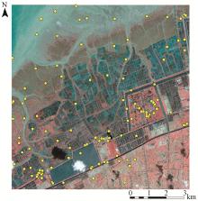
Fig.1
QuickBird remote sensing image and sample distribution"


Fig.2
Experimental flowchart"
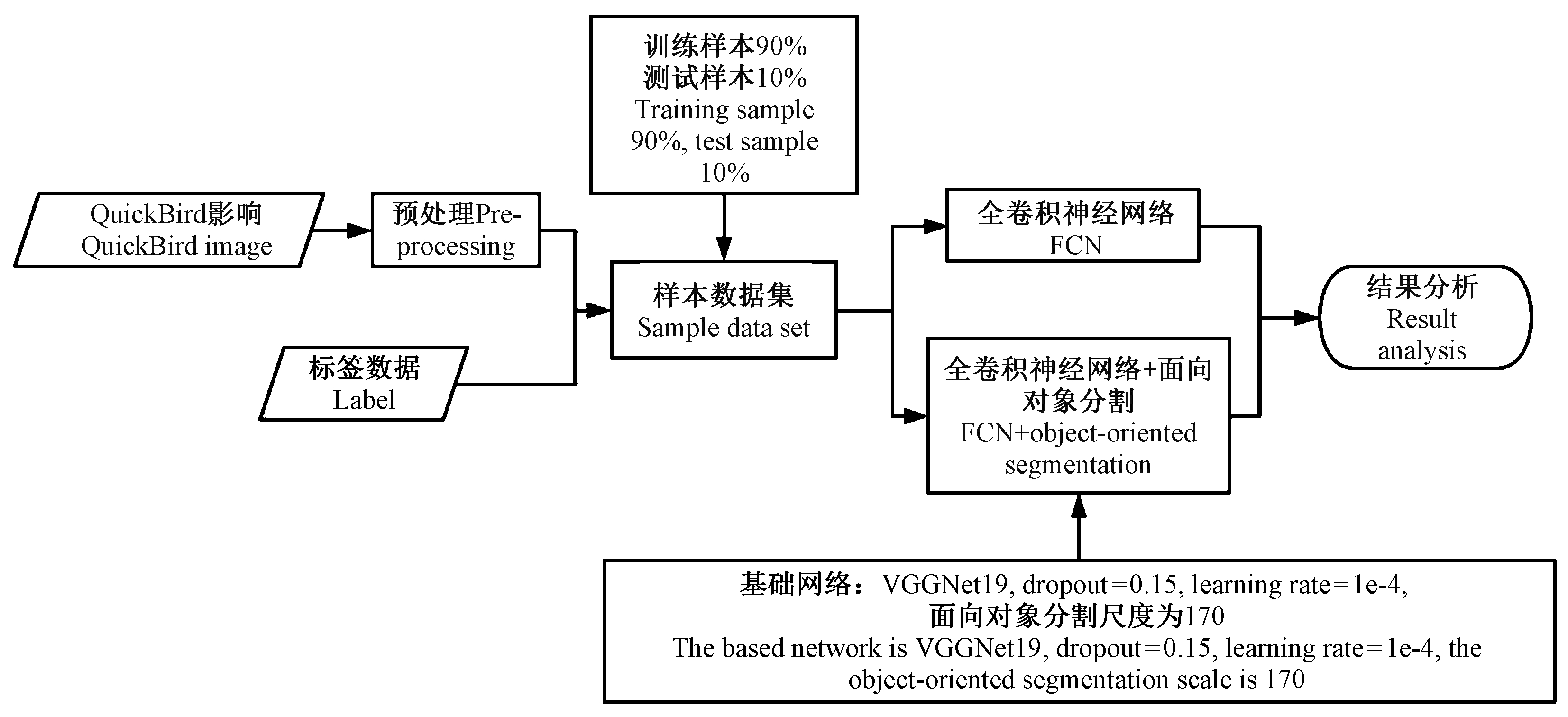

Fig.3
Model structure diagram"
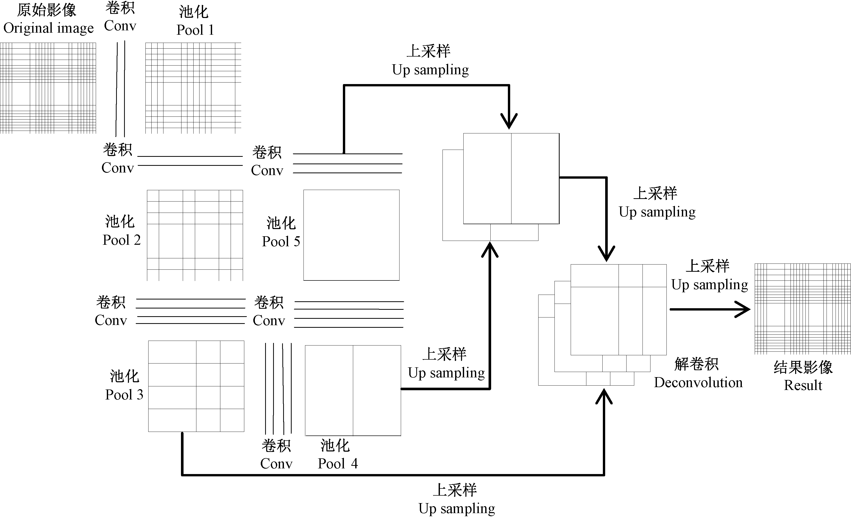
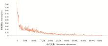
Fig.4
The chart of FCN training loss"
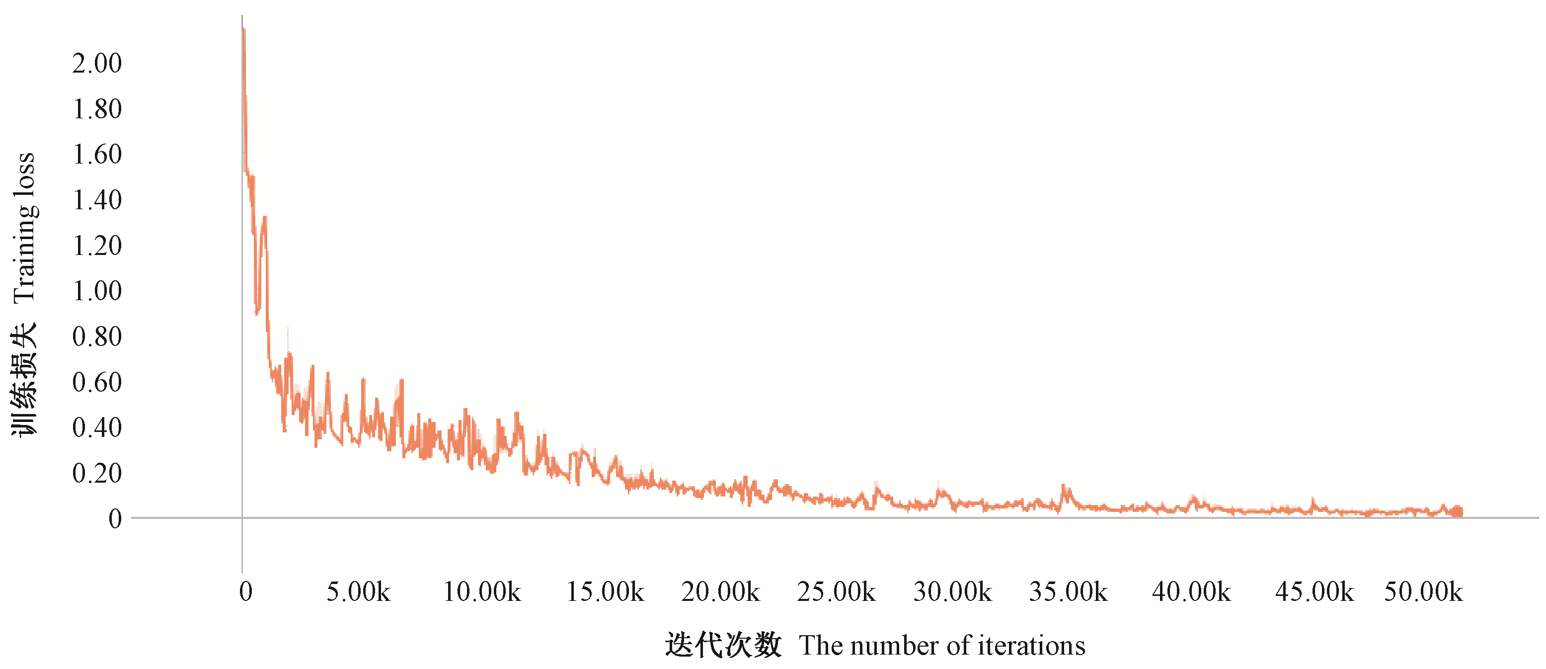
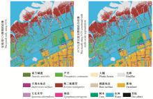
Fig.5
The result of the experiment"

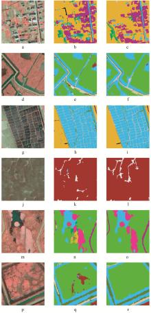
Fig.6
Comparison of some results of the two schemes Original picture(a, d, g, j, m, p), result picture of scheme one(b, e, h, k, n, q), and result picture of scheme two(c, f, i, l, o, r). "

Table 1
The confusion matrix of scheme one"
| 0 | 1 | 2 | 3 | 4 | 5 | 6 | 7 | 8 | 9 | 10 | 11 | 12 | 分类合计 Total | 用户精度 User accuracy(%) | |
| 0 | 45 | 0 | 0 | 0 | 0 | 1 | 1 | 0 | 0 | 0 | 0 | 0 | 0 | 47 | 95.74 |
| 1 | 0 | 41 | 0 | 0 | 2 | 0 | 1 | 1 | 0 | 0 | 0 | 3 | 0 | 48 | 85.42 |
| 2 | 0 | 0 | 47 | 0 | 0 | 0 | 0 | 0 | 2 | 0 | 0 | 0 | 0 | 49 | 95.92 |
| 3 | 0 | 1 | 0 | 45 | 1 | 0 | 0 | 3 | 0 | 0 | 0 | 0 | 0 | 50 | 90.00 |
| 4 | 0 | 1 | 0 | 0 | 48 | 0 | 0 | 1 | 0 | 0 | 0 | 0 | 0 | 50 | 96.00 |
| 5 | 3 | 0 | 1 | 0 | 0 | 40 | 3 | 0 | 0 | 0 | 1 | 1 | 0 | 49 | 81.63 |
| 6 | 0 | 1 | 0 | 0 | 0 | 0 | 44 | 0 | 0 | 0 | 0 | 0 | 0 | 45 | 97.78 |
| 7 | 0 | 0 | 1 | 0 | 0 | 1 | 0 | 48 | 0 | 0 | 0 | 0 | 0 | 50 | 96.00 |
| 8 | 0 | 0 | 1 | 0 | 0 | 1 | 0 | 0 | 46 | 0 | 0 | 0 | 0 | 48 | 95.83 |
| 9 | 0 | 0 | 0 | 0 | 0 | 0 | 0 | 0 | 0 | 50 | 0 | 0 | 0 | 50 | 100.00 |
| 10 | 0 | 0 | 0 | 0 | 0 | 0 | 0 | 0 | 0 | 0 | 39 | 0 | 0 | 39 | 100.00 |
| 11 | 0 | 0 | 0 | 0 | 1 | 1 | 1 | 0 | 0 | 0 | 0 | 46 | 0 | 49 | 93.88 |
| 12 | 0 | 0 | 0 | 0 | 0 | 0 | 0 | 0 | 0 | 0 | 0 | 0 | 50 | 50 | 100.00 |
| 实测合计 Measured aggregate | 48 | 44 | 50 | 45 | 52 | 44 | 50 | 53 | 48 | 50 | 40 | 50 | 50 | 624 | |
| 制图精度 Producer accuracy(%) | 93.75 | 93.18 | 94.00 | 100.00 | 92.31 | 90.91 | 88.00 | 90.57 | 95.83 | 100.00 | 97.50 | 92.00 | 100.00 | 总体精度 Overall accuracy=94.39 | |
| 总体Kappa系数(K) Overall Kappa coefficient | 0.939 2 | ||||||||||||||
Table 2
The confusion matrix of scheme two"
| 0 | 1 | 2 | 3 | 4 | 5 | 6 | 7 | 8 | 9 | 10 | 11 | 12 | 分类合计 Total | 用户精度 User accuracy(%) | |
| 0 | 42 | 0 | 0 | 0 | 0 | 0 | 0 | 0 | 0 | 0 | 0 | 0 | 0 | 42 | 100.00 |
| 1 | 0 | 45 | 1 | 0 | 0 | 1 | 3 | 0 | 0 | 0 | 0 | 0 | 0 | 50 | 90.00 |
| 2 | 0 | 0 | 47 | 0 | 0 | 0 | 0 | 0 | 0 | 0 | 0 | 0 | 0 | 47 | 100.00 |
| 3 | 0 | 0 | 0 | 50 | 0 | 0 | 0 | 0 | 0 | 0 | 0 | 0 | 0 | 50 | 100.00 |
| 4 | 0 | 0 | 0 | 0 | 47 | 0 | 0 | 0 | 0 | 0 | 0 | 0 | 0 | 47 | 100.00 |
| 5 | 0 | 0 | 0 | 0 | 0 | 49 | 0 | 0 | 0 | 0 | 0 | 1 | 0 | 50 | 98.00 |
| 6 | 0 | 1 | 0 | 0 | 0 | 0 | 45 | 0 | 0 | 0 | 0 | 0 | 0 | 46 | 97.83 |
| 7 | 0 | 0 | 0 | 0 | 0 | 1 | 0 | 49 | 0 | 0 | 0 | 0 | 0 | 50 | 98.00 |
| 8 | 0 | 0 | 0 | 0 | 0 | 0 | 0 | 1 | 47 | 0 | 0 | 0 | 0 | 48 | 97.92 |
| 9 | 0 | 0 | 0 | 0 | 0 | 0 | 0 | 0 | 0 | 49 | 0 | 0 | 0 | 49 | 100.00 |
| 10 | 0 | 0 | 0 | 0 | 0 | 0 | 0 | 0 | 0 | 0 | 39 | 0 | 0 | 39 | 100.00 |
| 11 | 0 | 2 | 0 | 0 | 1 | 1 | 1 | 0 | 0 | 0 | 0 | 43 | 0 | 48 | 89.58 |
| 12 | 0 | 0 | 0 | 0 | 0 | 0 | 1 | 0 | 0 | 0 | 0 | 0 | 48 | 49 | 97.96 |
| 实测合计 Measured aggregate | 42 | 48 | 48 | 50 | 48 | 52 | 50 | 50 | 47 | 49 | 39 | 44 | 48 | 615 | |
| 制图精度 Producer accuracy(%) | 100.00 | 93.75 | 97.92 | 100.00 | 97.92 | 94.23 | 90.00 | 98.00 | 100.00 | 100.00 | 100.00 | 97.73 | 100.00 | 总体精度 Overall accuracy=97.56 | |
| 总体Kappa系数(K) Overall Kappa coefficient | 0.973 6 | ||||||||||||||
| 方旭, 王光辉, 杨化超, 等. 结合均值漂移分割与全卷积神经网络的高分辨遥感影像分类. 激光与光电子学进展, 2018. 55 (2): 446- 454. | |
| Fang X , Wang G H , Yang H C , et al. High resolution remote sensing image classification combining with mean-shift segmentation and fully convolution neural network. Laser & Optoelectronics Progress, 2018. 55 (2): 446- 454. | |
| 和晓风, 林辉, 孙华, 等. 基于GF-1卫星东洞庭湖湿地类型信息提取. 中南林业科技大学学报, 2015. 35 (11): 10- 15. | |
| He X F , Lin H , Sun H , et al. Wetland types information extraction form east Dongting Lake based on GF-1 satellite. Journal of Central South University of Forestry & Technology, 2015. 35 (11): 10- 15. | |
| 祁增营, 王京, 左正立. 湿地变化监测研究现状与展望. 遥感信息, 2012. 27 (6): 124- 132. | |
| Qi Z Y , Wang J , Zuo Z L . Current status and prospect of researches on wetland change monitoring. Remote Sensing Information, 2012. 27 (6): 124- 132. | |
| 汤浩, 何楚. 全卷积网络结合改进的条件随机场-循环神经网络用于SAR图像场景分类. 计算机应用, 2016. 36 (12): 3436- 3441. | |
| Tang H , He C . SAR image scene classification with fully convolutional network and modified conditional random field-recurrent neural network. Journal of Computer Applications, 2016. 36 (12): 3436- 3441. | |
| 王露. 2014.面向对象的高分辨率遥感影像多尺度分割参数及分类研究.长沙:中南大学硕士学位论文. | |
| Wang L. 2014. Multi-scale segmentation parameters and classification of object-oriented high-resolution remote sensing images. Changsha: MS thesis of Central South University.[in Chinese] | |
| 徐逸之, 姚晓婧, 李祥, 等. 基于全卷积网络的高分辨遥感影像目标检测. 测绘通报, 2018. (1): 77- 82. | |
| Xu Y Z , Yao X J , Li X , et al. Object detection in high resolution remote sensing images based on fully convolution networks. Bulletin of Surveying and Mapping, 2018. (1): 77- 82. | |
| 张春晓, 侯伟, 刘翔, 等. 基于面向对象和影像认知的遥感影像分类方法——以都江堰向峨乡区域为例. 测绘通报, 2010. (4): 11- 14. | |
| Zhang C X , Hou W , Liu X , et al. Remote sensing image classification based on object-oriented and image cognition-a case study in Xiang'e, Dujiangyan. Bulletin of Surveying and Mapping, 2010. (4): 11- 14. | |
| 张猛, 曾永年, 朱永森. 面向对象方法的时间序列MODIS数据湿地信息提取——以洞庭湖流域为例. 遥感学报, 2017. 21 (3): 479- 492. | |
| Zhang M , Zeng Y N , Zhu Y S . Wetland mapping of Donting Lake Basin based on time-series MODIS data and object-oriented method. Journal of Remote Sensing, 2017. 21 (3): 479- 492. | |
| 郑云云, 胡泓, 邵志芳. 典型滨海地植被演替研究进展. 湿地科学与管理, 2013. (4): 56- 60. | |
| Zheng Y Y , Hu H , Shao Z F . Progress in studies of vegetation succession in typical coastal wetlands. Wetland Science & Management, 2013. (4): 56- 60. | |
| 周禹. 浅谈基于无人机遥感的湿地植被监测. 城市地理, 2017. (2): 79. | |
| Zhou Y . Discussion on wetland vegetation monitoring based on UAV remote sensing. Cultural Geography, 2017. (2): 79. | |
| 周在明, 杨燕明, 陈本清. 基于无人机遥感监测滩涂湿地入侵种互花米草植被覆盖度. 应用生态学报, 2016. 27 (12): 3920- 3926. | |
| Zhou Z M , Yang Y M , Chen B Q . Fractional vegetation cover of invasive Spartina alterniflora in coastal wetland using unmanned aerial vehicle(UAV) remote sensing. Chinese Journal of Applied Ecology, 2016. 27 (12): 3920- 3926. | |
| Boon M A, Tesfsmichael S. 2017. Wetland vegetation integrity assessment with low altitude multispectral UAV imagery. ISPRS-International Archives of the Photogrammetry, Remote Sensing and Spatial Information Sciences, XLⅡ-2/W6: 55-62. | |
| Bittner K, Cui S, Reinartz P. 2017. Building extraction from remote sensing data using fully convolutional networks. ISPRS-International Archives of the Photogrammetry, Remote Sensing and Spatial Information Sciences, XLⅡ-1/W1: 481-486. | |
| Chavez P S , Berlin G L , Sowers L B . Statistical method for selecting Landsat MSS ratios. Journal of Applied Photographic Engineering, 1982. 8 (1): 23- 30. | |
|
Corcoran J M , Knight J F , Gallant A L . Influence of multi-source and multi-temporal remotely sensed and ancillary data on the accuracy of random forest classification of wetlands in northern Minnesota. Remote Sensing, 2013. 5 (7): 3212- 3238.
doi: 10.3390/rs5073212 |
|
|
Fu G , Liu C , Zhou R , et al. Classification for high resolution remote sensing imagery using a fully convolutional network. Remote Sensing, 2017. 9 (5): 498- 519.
doi: 10.3390/rs9050498 |
|
| Johnson B , Xie Z . Unsupervised image segmentation evaluation and refinement using a multi-scale approach. ISPRS Journal of Photogrammetry & Remote Sensing, 2011. 66 (4): 473- 483. | |
| Krizhevsky A , Sutskever I , Hinton G E . ImageNet classification with deep convolutional neural networks. Advances in Neural Information Processing Systems, 2012. 25 (2): 1097- 1105. | |
| Li R , Liu W , Yang L , et al. DeepUNet:a deep fully convolutional network for pixel-level sea-land segmentation. IEEE Journal of Selected Topics in Applied Earth Observations & Remote Sensing, 2018. 11 (11): 3954- 3962. | |
|
Penger B W , Johnston C A , Loveland T R . Mapping an invasive plant, Phragmites australis, in coastal wetlands using the EO-1 Hyperion hyperspectral sensor. Remote Sensing of Environment, 2007. 108 (1): 74- 81.
doi: 10.1016/j.rse.2006.11.002 |
|
| Piramanayagam S, Schwartzkopf W, Koehler F W, et al. 2016. Classification of remote sensed images using random forests and deep learning framework//SPIE remote sensing. Proceedings of the SPIE, 8. | |
|
Rao B R M , Dwivedi R S , Kushwaha S P S , et al. Monitoring the spatial extent of coastal wetlands using ERS-1 SAR data. International Journal of Remote Sensing, 1999. 20 (13): 2509- 2517.
doi: 10.1080/014311699211903 |
|
|
Shelhamer E , Long J , Darrel T . Fully convolutional networks for semantic segmentation. IEEE Transactions on Pattern Analysis and Machine Intelligence, 2017. 39 (4): 640- 651.
doi: 10.1109/TPAMI.2016.2572683 |
|
| Sherrah J. 2016. Fully convolutional networks for dense semantic labelling of high-resolution aerial imagery.arXiv ID: 1606.02585. | |
| Simonyan K, Zisserman A. 2014. Very deep convolutional networks for large-scale image recognition. Computer Science. arXiv preprint arXiv: 1409.1556. | |
| Sun W , Wang R . Fully convolutional networks for semantic segmentation of very high resolution remotely sensed images combined with DSM. IEEE Geoscience & Remote Sensing Letters, 2018. 99, 1- 5. | |
| Szegedy C, Liu W, Jia Y, et al. 2015. Going deeper with convolutions//Proceedings of the IEEE Conference on Computer Vision and Pattern Recognition, 1-9. |
| [1] | Liu Jinli, Chen Zhao, Gao Jinping, Gao Xianlian, Sun Zhongqiu. Research on the Method of Determining the Optimal Segmentation Scale for Tree Species Classification of High-Resolution Image [J]. Scientia Silvae Sinicae, 2019, 55(11): 95-104. |
| [2] | Wen Amin, Zheng Jianghua, Chen Meng, Mu Chen, Ma Tao. Monitoring Mouse-Hole Density by Rhombomys opimus in Desert Forests with UAV Remote Sensing Technology [J]. Scientia Silvae Sinicae, 2018, 54(4): 186-192. |
| [3] | Zhang Yuxing, Wang Xuejun, Huang Guosheng, Dang Yongfeng, Chen Xinyun. Forest Area Remote Sensing Monitoring Using the Multi-Level Sampling Interpretation Approach [J]. Scientia Silvae Sinicae, 2017, 53(7): 94-104. |
| [4] | Xing Zefeng, Li Ying, Deng Rongxin, Zhu Honglei, Fu Bolin. Extracting Farmland Shelterbelt Automatically Based on ZY-3 Remote Sensing Images [J]. Scientia Silvae Sinicae, 2016, 52(4): 11-20. |
| [5] | Zhou Jingjing, Zhao Zhong, Liu Jinliang, Zhao Jun, Zhao Qingxia, Liu Jun. A Comparison of Different Quickbird Image Information for Estimating the Effective Leaf Area Index of Robinia pseudoacacia Plantations [J]. Scientia Silvae Sinicae, 2015, 51(9): 24-34. |
| [6] | Sun Xiaoyan, Du Huaqiang, Han Ning, Ge Hongli, Gu Chengyan. Multi-Scale Segmentation, Object-Based Extraction of Moso Bamboo Forest from SPOT 5 Imagery [J]. Scientia Silvae Sinicae, 2013, 49(10): 80-87. |
| [7] | Feng Yiming;Zheng Dongmei;Zhi Changgui;Yao Aidong;Gao Zhihai. Desertification Land Information Extraction Based on Object-Oriented Classification Method [J]. , 2013, 49(1): 126-133. |
| [8] | Li Chungan;Shao Guofan. Object-Oriented Classification of Forest Cover Using SPOT5 Imagery [J]. Scientia Silvae Sinicae, 2010, 46(8): 130-139. |
| [9] | Mo Weihua;Wang Junhua;Zhong Shiquan;Chen Yanli. Techniques for Monitoring and Evaluating the Snow and Ice Disaster Base on MODIS Model [J]. Scientia Silvae Sinicae, 2009, 12(10): 88-93. |
| [10] | Wang Xiaohui;Li Zengyuan;Gao Zhihai. Studies on Remote Sensing Monitoring of Sandification [J]. Scientia Silvae Sinicae, 2008, 44(7): 90-96. |
| [11] | Huang Jianwen;Chen Yongfu;Ju Hongbo. Study on Tree-Crown Extraction from QuickBird Imagery Based on Object-Oriented Approach in the Project of Converting Cropland to Forest [J]. , 2006, 42(zk): 65-71. |
| [12] | Gan Shu;He Daming;Yuan Xiping. STUDY ON REMOTE SENSING MONITORING FOREST COVER BY NDVI TECHNIQUE IN MOUNTAIN AREA OF LANCANG RIVER BASIN [J]. Scientia Silvae Sinicae, 2001, 37(4): 134-136. |
| Viewed | ||||||
|
Full text |
|
|||||
|
Abstract |
|
|||||