
Scientia Silvae Sinicae ›› 2022, Vol. 58 ›› Issue (3): 107-116.doi: 10.11707/j.1001-7488.20220312
Previous Articles Next Articles
Linlin Hu1,Lizhong Wang1,Hua Li1,Yongquan Ding1,Changlei Wei1,Huiren Li1,Fengjun Zhao2,*
Received:2021-03-01
Online:2022-03-25
Published:2022-06-02
Contact:
Fengjun Zhao
CLC Number:
Linlin Hu,Lizhong Wang,Hua Li,Yongquan Ding,Changlei Wei,Huiren Li,Fengjun Zhao. Application of PL High Resolution Remote Sensing Image in Forest Fire Assessment[J]. Scientia Silvae Sinicae, 2022, 58(3): 107-116.
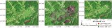
Fig.1
Mosaic images covering the study area"

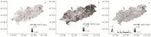
Fig.2
NDVI changes of burned area in Bilahe a: One year before fire; b: Two month after fire; c: One year after fire.The same below."
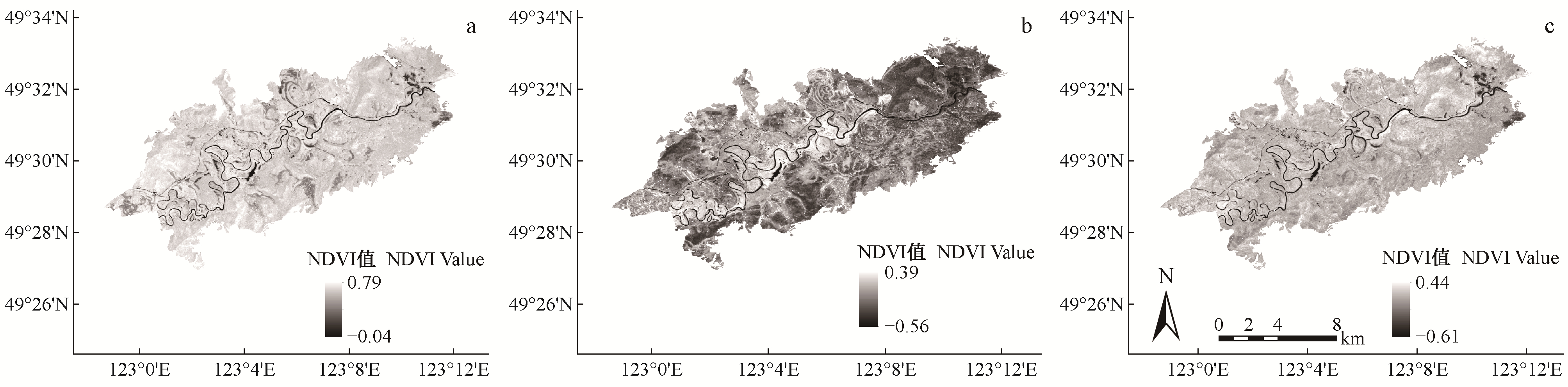

Fig.3
NDVI histograms of burned area in Bilahe"
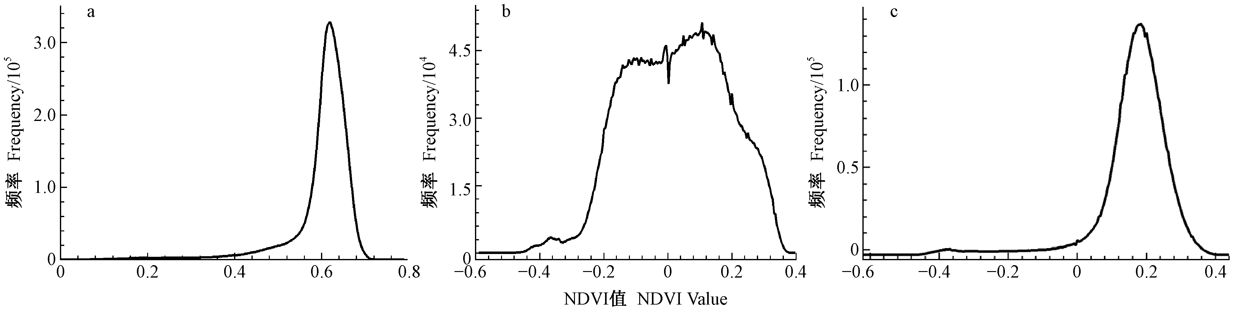
Table 1
NDVI numerical statistics"
| NDVI时序 Time series of NDVI | 最小值 Min | 最大值 Max | 平均值 Mean | 标准差 SD |
| 20160706 | -0.04 | 0.79 | 0.60 | 0.08 |
| 20170702 | -0.59 | 0.40 | 0.03 | 0.16 |
| 20180722 | -0.62 | 0.44 | 0.17 | 0.11 |

Fig.4
2016 PL remote sensing image of study area in Bilahe Forestry Center"
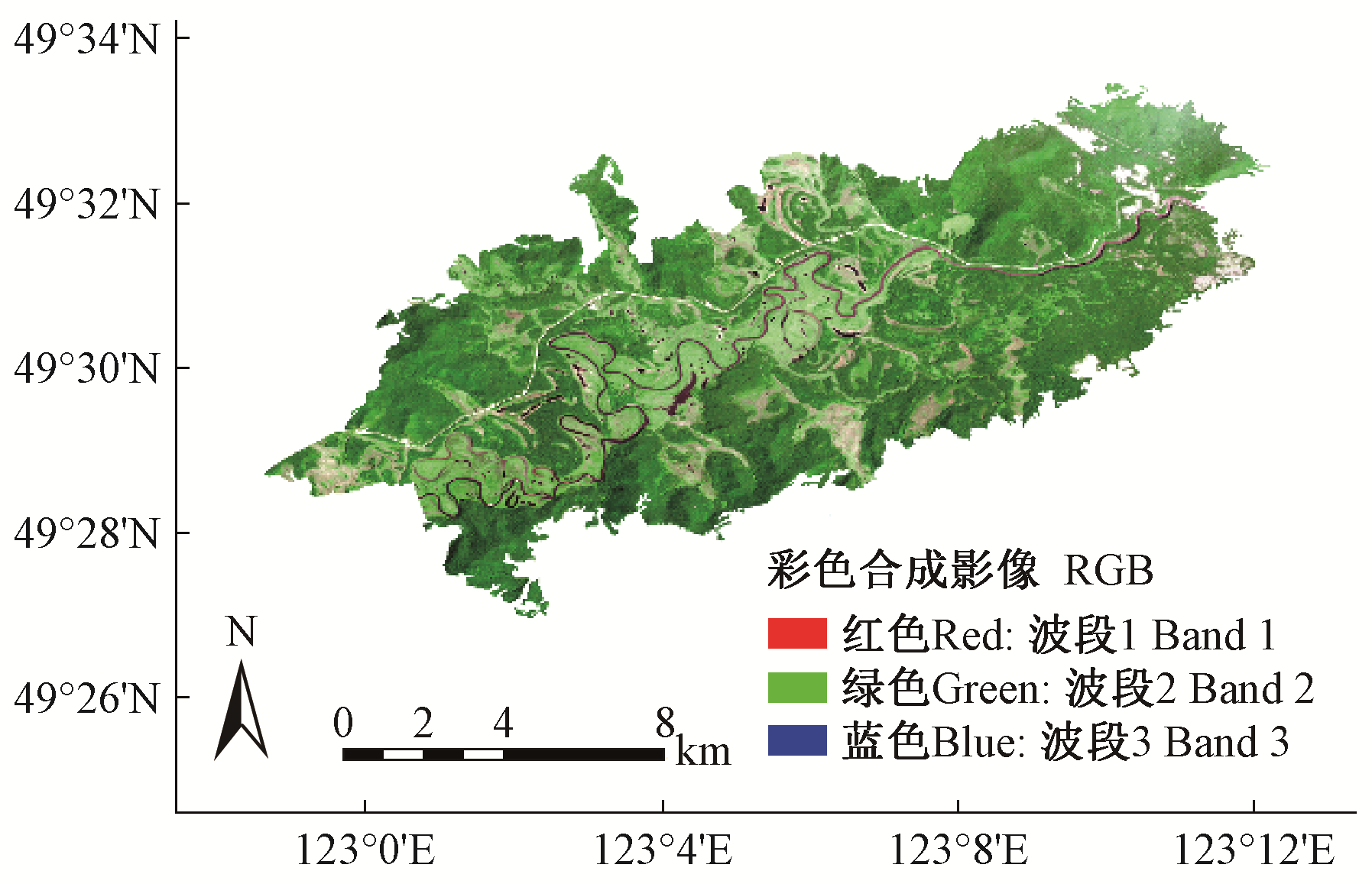
Table 2
Computation of separation of ROI for training samples"
| 土地覆盖类型 Land cover types | Jeffries Matusita | Transformed Divergence | |
| 草本沼泽Herbaceous swamp | 森林Forest | 1.94 | 1.95 |
| 草本沼泽Herbaceous swamp | 道路Road | 1.91 | 1.99 |
| 水体River | 道路/Road | 2.00 | 2.00 |
| 草本沼泽Herbaceous swamp | 水体/River | 1.91 | 1.92 |
| 森林Forest | 水体/River | 1.93 | 1.96 |
| 森林Forest | 道路/Road | 1.98 | 2.00 |
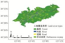
Fig.5
Classification of land cover types of the study area based on 2016 PL remote sensing image"

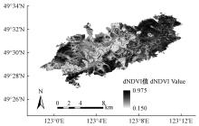
Fig.6
Image of dNDVI"

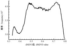
Fig.7
Histogram of dNDVI"

Table 3
Fire severity classification"
| 火烧等级 Fire severity levels | 编号 Code | dNDVI阈值 Threshold of dNDVI |
| 未火烧Unburned | 0 | < 0.34 |
| 轻度Light | 1 | 0.34~0.56 |
| 中度Moderate | 2 | 0.57~0.74 |
| 重度Severe | 3 | >0.75 |
Table 4
Validation sample data of dNDVI threshold"
| 火烧等级 Fire severity levels | 经度 Longitude | 纬度 Latitude | 乔木总株数 Total number of trees | 火烧死亡株数 Number of fire dead trees | 自然死亡株数 Humber of natural death | 火烧死亡株数百分比 Percentage of fire dead trees(%) |
| 未火烧区 Unburned | 123°0′47.688″E | 49°29′1.248″N | 881 | 0 | 11 | 0 |
| 122°59′42.776″E | 49°28′59.812″N | 1 020 | 0 | 15 | 0 | |
| 123°7′49.213″E | 49°37′38.485″N | 955 | 0 | 22 | 0 | |
| 123°10′11.578″E | 49°32′37.639″N | 758 | 0 | 13 | 0 | |
| 123°5′18.627″E | 49°31′3.408″N | 1 203 | 0 | 28 | 0 | |
| 轻度火烧 Light | 123°1′3.202″E | 49°29′17.956″N | 682 | 40 | 20 | 5.87 |
| 123°0′2.153″E | 49°29′8.703″N | 756 | 50 | 15 | 6.61 | |
| 123°2′8.908″E | 49°29′59.35″N | 623 | 48 | 12 | 7.70 | |
| 123°7′44.742″E | 49°31′34.168″N | 662 | 126 | 19 | 19.03 | |
| 123°10′13.566″E | 49°32′37.81″N | 589 | 157 | 25 | 26.66 | |
| 中度火烧 Moderate | 123°1′8.791″E | 49°29′22.775″N | 650 | 339 | 15 | 43.18 |
| 122°59′57.373″E | 49°29′2.844″N | 785 | 369 | 12 | 47.00 | |
| 123°2′9.387″E | 49°30′9.355″N | 693 | 378 | 10 | 54.55 | |
| 123°8′1.291″E | 49°31′20.445″N | 588 | 324 | 17 | 55.10 | |
| 123°10′18.627″E | 49°32′37.022″N | 569 | 359 | 19 | 63.09 | |
| 重度火烧 Severe | 123°0′54.91″E | 49°29′12.885″N | 346 | 320 | 6 | 92.49 |
| 122°59′48.584″E | 49°29′1.662″N | 420 | 352 | 5 | 83.81 | |
| 123°2′9.319″E | 49°30′3.53″N | 398 | 330 | 6 | 82.91 | |
| 123°8′11.416″E | 49°31′21.319″N | 360 | 299 | 2 | 83.05 | |
| 123°10′16.53″E | 49°32′39.009″N | 398 | 289 | 2 | 72.61 |
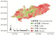
Fig.8
Distribution of image of fire severity levels"

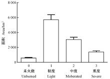
Fig.9
Area statistics of different fire grades"
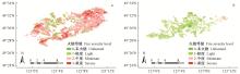
Fig.10
Distribution of fire severity levels of forests(a) and herbaceous marshes(b)"
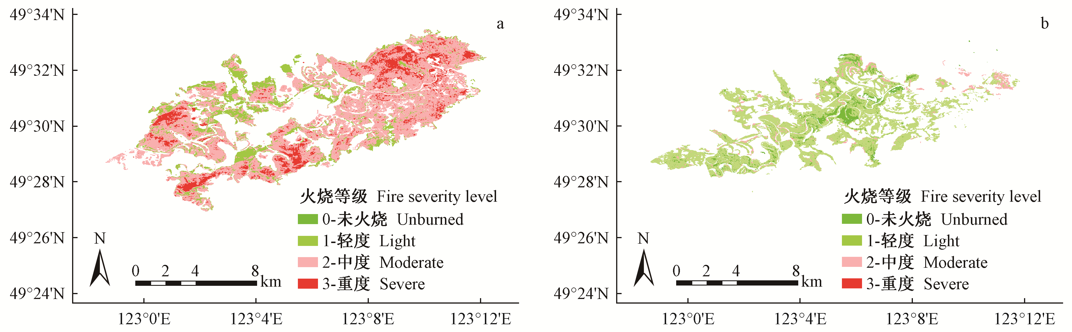
Table 5
Area percent of different fire severity levels of forests and herbaceous swamp"
| 各植被类型面积及占比 Area and proportion of each vegetation type | 轻度火烧区 Light burned area | 中度火烧区 Moderate burned area | 重度火烧区 Severe burned area |
| 森林面积Area of forest/hm2 | 1 846.93 | 2 926.56 | 1 393.98 |
| 草本沼泽面积Area of herbaceous swamp/hm2 | 3 853.84 | 108.56 | 0.45 |
| 森林占比Proportion of forest(%) | 22.60 | 29.95 | 47.45 |
| 草本沼泽占比Proportion of herbaceous swamp(%) | 2.74 | 0.01 | 97.25 |
| 丁海勇, 吴月. 基于中分辨率成像遥感数据的毕拉河林场林火信息监测. 济南大学学报(自然科学版), 2020, 34 (3): 231- 246. | |
| Ding H Y , Wu Y . Fire information detection of the bilahe forest based on moderate resolution imaging spectroradiometer data. Journal of University of Jinan (Science and Technology), 2020, 34 (3): 231- 246. | |
| 付建新, 曹广超, 郭文炯. 1998—2017年祁连山南坡不同海拔、坡度和坡向生长季NDVI变化及其与气象因子的关系. 应用生态学报, 2020, 31 (4): 1203- 1212. | |
| Fu J X , Cao G C , Guo W J . Changes of growing season NDVI at different elevations, slopes, slope aspects and its relationship with meteorological factors in the southern slope of the Qilian Mountains, China from 1998 to 2017. Chinese Journal of Applied Ecology, 2020, 31 (4): 1203- 1212. | |
| 高世忠, 周万村, 范建容, 等. 森林火灾后生态变化监测中植被指数提取方法的研究. 遥感信息, 1997, (1): 15- 19. | |
| Gao S Z , Zhou W C , Fan J R , et al. Study on extraction method of vegetation index in ecological change monitoring after forest fire. Remote Sensing Information, 1997, (1): 15- 19. | |
|
高铁山. 基于时空维度分析的网络安全态势预测方法. 网络安全技术与应用, 2018, (3): 20- 21.
doi: 10.3969/j.issn.1009-6833.2018.03.017 |
|
|
Gao T S . Network security situation prediction method based on spatio-temporal dimension analysis. Network Security Technology and Application, 2018, (3): 20- 21.
doi: 10.3969/j.issn.1009-6833.2018.03.017 |
|
| 李明泽, 康祥瑞, 范文义. 呼中林区火烧迹地遥感提取及林火烈度的空间分析. 林业科学, 2017, 53 (3): 163- 174. | |
| Li M Z , Kang X R , Fan W Y . Burned area extraction in Huzhong forests based on remote sensing and the spatial analysis of the burned severity. Scientia Silvae Sinicae, 2017, 53 (3): 163- 174. | |
|
李文辉. 浅谈毕拉河林业局立地类型分布特点. 内蒙古林业调查设计, 2010, 33 (3): 48- 50.
doi: 10.3969/j.issn.1006-6993.2010.03.021 |
|
|
Li W H . Discussion on site type distribution characteristics of bila River Forestry Bureau. Inner Mongolia Forestry Investigation and Design, 2010, 33 (3): 48- 50.
doi: 10.3969/j.issn.1006-6993.2010.03.021 |
|
| 罗德昆. 大兴安岭过火迹地更新方式的研讨. 林业科技, 1987, 53 (1): 10- 12. | |
| Luo D K . Discussion on the regeneration mode of burned land in Daxing'an Mountains. Forestry Science and Technology, 1987, 53 (1): 10- 12. | |
| 刘树超, 陈小中, 覃先林, 等. 内蒙古毕拉河林场森林火灾受害程度遥感评价. 林业资源管理, 2018, 53 (1): 90- 96. | |
| Liu S C , Chen X Z , Qin X L , et al. Remote sensing assessment of forest fire damage degree in Bilahe Forest Farm, Inner Mongolia. Forest Resources Management, 2018, 53 (1): 90- 96. | |
| 马礼, 罗建松, 王逸凯. 基于多源遥感数据的森林火灾监测研究. 测绘与空间地理信息, 2021, 44 (5): 141- 145. | |
| Ma L , Luo J S , Wang Y K . Research on forest fire monitoring based on multi-source remote sensing data. Geomatics and Spatial Information Technology, 2021, 44 (5): 141- 145. | |
| 苗庆林, 田晓瑞, 赵凤君. 大兴安岭不同植被火后NDVI恢复过程. 林业科学, 2015, 51 (2): 90- 98. | |
| Miao Q L , Tian X R , Zhao F J . NDVI recovery process for post-fire vegetation in Daxing'anling. Scientia Silvae Sinicae, 2015, 51 (2): 90- 98. | |
| 莫瑶, 邓有飞, 陈怀亮, 等. 1982-2000年黄淮海地区植被覆盖变化特征分析. 遥感技术与应用, 2007, 22 (3): 397- 398. | |
| Mo Y , Deng Y F , Chen H L , et al. Analysis on the vegetation cover change in the HHH Zone of China in 1982-2000. Remote Sensing Technology and Application, 2007, 22 (3): 397- 398. | |
| 邱成, 胡金明, 杨飞龄. 基于NDVI的云南省自然保护区保护成效分析. 生态学报, 2020, 40 (20): 7312- 7322. | |
| Qiu C , Hu J M , Yang F L . Analysis of conservation effectiveness of nature reserves based on NDVI in Yunnan Province. Acta Ecological Sinica, 2020, 40 (20): 7312- 7322. | |
| 王小霞, 刘志华, 焦珂伟. 2000—2017年东北森林NDVI时空动态及其驱动因子. 生态学杂志, 2020, 39 (9): 2878- 2886. | |
| Wang X X , Liu Z H , Jiao K W . Spatiotemporal dynamics of normalized difference vegetation index (NDVI) and its drivers in forested region of Northeast China during 2000-2017. Chinese Journal of Ecology, 2020, 39 (9): 2878- 2886. | |
| 王爱爱, 臧淑英, 王翠珍. 重建NDVI时间序列及火后森林恢复时空动态分析. 哈尔滨师范大学自然科学学报, 2017, 33 (4): 54- 61. | |
| Wang A A , Zang S Y , Wang C Z . Reconstruction of NDVI time series and spatio-temporal dynamic analysis of post fire forest restoration. Natural Sciences Journal of Harbin Normal University, 2017, 33 (4): 54- 61. | |
| 王爱爱. 2018. NDVI时间序列重建及火后森林恢复时空动态分析. 哈尔滨: 哈尔滨师范大学. | |
| Wang A A. 2018. Reconstruction of NDVI time series and spatio-temporal dynamic analysis of post fire forest restoration. Harbin: Harbin Normal University. [in Chinese] | |
| 吴建台, 乔翌峰, 朱赛凡, 等. 基于HMM的网络安全态势评估与预测方法. 导航与控制, 2018, 17 (2): 10- 17. 10-17, 31 | |
| Wu J T , Qiao Y F , Zhu S F , et al. Cybersecurity situation evaluation method based on association analysis and hidden markov model. Navigation and Control, 2018, 17 (2): 10- 17. 10-17, 31 | |
| 熊得祥, 谭三清, 张贵, 等. 基于FY4遥感数据的森林火灾判别研究. 中南林业科技大学学报, 2020, 40 (10): 42- 50. | |
| Xiong D X , Tan S Q , Z G , et al. Forest fire discrimination research based on FY4 remote sensing data. Journal of Central South University of Forestry & Technology, 2020, 40 (10): 42- 50. | |
| 杨伟, 张树文, 姜晓丽. 基于MODIS时序数据的黑龙江流域火烧迹地提取. 生态学报, 2015, 35 (17): 5866- 5873. | |
| Yang W , Zhang S W , Jiang X L . Burned area mapping for Heilongjiang basin based on MODIS time series data. Acta Ecologica Sinica, 2015, 35 (17): 5866- 5873. | |
| 伊坤朋, 包玉龙. 遥感技术在火监测中的应用研究综述. 世界林业研究, 2016, 29 (4): 36- 41. | |
| Yi K P , Bao Y L . A Review on applications and contributions of remote sensing techniques in fire monitoring. World Forestry Research, 2016, 29 (4): 36- 41. | |
| 张凌峰. 内蒙古毕拉河林业局森林资源现状及分布特点. 内蒙古林业调查设计, 2013, 36 (1): 52- 54. | |
| Zhang L F . The present situation and distribution of forest resource of the Bilahe bureau in Inner Mongolia. Inner Mongolia Forestry Investigation and Design, 2013, 36 (1): 52- 54. | |
| 赵凤君, 王立中, 舒立福, 等. 寒温带湿地火后植被恢复的影响因子. 应用生态学报, 2013, 24 (3): 853- 860. | |
| Zhao F J , Wang L Z , Shu L F , et al. Factors affecting the vegetation restoration after fires in cold temperate wetlands: A review. Chinese Journal of Applied Ecology, 2013, 24 (3): 853- 860. | |
| 祖笑锋, 覃先林, 尹凌宇, 等. 基于高分一号影像光谱指数识别火烧迹地的决策树方法. 林业资源管理, 2015, (4): 73- 78. 73-78, 83 | |
| Zu X F , Qin X L , Yin L Y , et al. Decision tree method for burned area identification based on the spectral index of GF-1 WFV Image. Forest Resources Management, 2015, (4): 73- 78. 73-78, 83 | |
| Addison P , Oommen T . Post-fire debris flow modeling analyses: Case study of the post-Thomas Fire event in California. Natural Hazards, 2020, 100, 329- 343. | |
| Bajocco S , Koutsias N , Ricotta C . Linking fire ignitions hotspots and fuel phenology: The importance of being seasonal. Ecological Indicators, 2017, 82, 433- 440. | |
| Kimm H , Guan K Y , Jiang C Y , et al. Deriving high-spatiotemporal-resolution leaf area index for agroecosystems in the U. S. Corn Belt using Planet Labs CubeSat and STAIR fusion data. Remote Sensing of Environment, 2020, 239, 239- 252. | |
| Michael Y , Lensky I M , Brenner S . Economic assessment of fire damage to urban forest in the wildland-urban interface using planet satellites constellation images. Remote Sensing, 2018, 10 (9): 1479- 1502. | |
| Yasunaka Y , Oishi K , Anazi H , et al. Assessing the effect of controlled burning and grazing on vegetation change in the grasslands of Aso region using satellite image analyses. Journal of the Japanese Agricutural Sysyems Society, 2015, 4, 117- 125. |
| [1] | Jiatian Hao,Yunyun Hu,Yichen Du,Xiaowei Hou,Anmin Xiang. NDVI-Based Coverage Changes of Forest and Grass Vegetation in Yellow River Basin during 2009 to 2018 [J]. Scientia Silvae Sinicae, 2022, 58(3): 10-19. |
| [2] | Rundong Li,Wendong Tian,Haiqun Yu,Xinhao Li,Chuan Jin,Peng Liu,Tianshan Zha,Yun Tian. Forest Phenology Estimation and Its Relationships with Corresponding Meteorological Factors Based on Digital Images in Songshan, Beijing, China [J]. Scientia Silvae Sinicae, 2022, 58(1): 89-97. |
| [3] | Zixuan Wang,Ding Wang,Pengwu Zhao,Qiyue Zhang,Lei Yang,Mei Zhou. Effects of Management Methods of Burned Wood on Soil Respiration and Its Components in the Permafrost Region of Cold Temperate Zone [J]. Scientia Silvae Sinicae, 2021, 57(8): 13-23. |
| [4] | Lihong Wang,Hongkun Gao,Yusen Zhao,Qiang Fu,Chuanyuan He,Xin Sun,Jianxin Liang,Xiaopeng Zhang. Regulation Effects of Burned Areas Vegetation Restoration on Forest Microclimate Characteristics in the Growing Season [J]. Scientia Silvae Sinicae, 2021, 57(4): 14-23. |
| [5] | Zhuang Yilin, Zhou Jinxing, Wu Xiuqin, Cao Jianhua, Zhang Weixin. Vegetation Change and It's Driving Forces in Karst Faulted Basins between 2001 and 2016 [J]. Scientia Silvae Sinicae, 2019, 55(9): 177-184. |
| [6] | Li Jie, Zhang Jun, Liu Chenli, Yang Xuchao. Spatiotemporal Variation of Vegetation Coverage in Recent 16 Years in the Border Region of China, Laos, and Myanmar Based on MODIS-NDVI [J]. Scientia Silvae Sinicae, 2019, 55(8): 9-18. |
| [7] | Li Ming, Zhang Huilan, Meng Chengcheng, Yang Wentao, Tian Yanyan. Spatial-Temporal Variations of Vegetation Coverage in Huangfuchuan Basin from 2000 to 2015 [J]. Scientia Silvae Sinicae, 2019, 55(8): 36-44. |
| [8] | Du Yichen, Li Mingze, Fan Wenyi, Wang Bin. Estimation of Forest Stand Age Based on GWR Model and Forest Fire Remote Sensing Data [J]. Scientia Silvae Sinicae, 2019, 55(6): 184-194. |
| [9] | Yang Yuping, Pan Cunde, Yu Gebi, Li Guihua, Liu Jing, Cui Qian, Liu Bo. Relationship between Taiga Forest Communities and Environment Factors in the Kanas and Fire Disturbance Factors [J]. Scientia Silvae Sinicae, 2019, 55(5): 114-124. |
| [10] | Min Zhang,Chunxiang Cao,Wei Chen. Remotely Sensed Diagnosing Temporal and Spatial Variation of Vegetation Coverage in Guangxi Based on MODIS NDVI Data [J]. Scientia Silvae Sinicae, 2019, 55(10): 27-37. |
| [11] | Yang Wei, Jiang Xiaoli. Review on Remote Sensing Information Extraction and Application of the Burned Forest Areas [J]. Scientia Silvae Sinicae, 2018, 54(5): 135-142. |
| [12] | Hu Zongda, Liu Shirong, Hu Jing, Liu Xingliang, Yu Hao, Li Dengfeng, He Fei. Soil Respiration Characteristics and Impacting Factors in Burned Area of Quercus aquifolioides in Western Sichuan, China [J]. Scientia Silvae Sinicae, 2018, 54(2): 18-29. |
| [13] | Li Xiaohong, Chen Erxue, Li Zengyuan, Li Shiming. Object Based Land Cover Classification Method Integrating Multi-Source Remote Sensing Data [J]. Scientia Silvae Sinicae, 2018, 54(2): 68-80. |
| [14] | Li Mingze, Kang Xiangrui, Fan Wenyi. Burned Area Extraction in Huzhong Forests Based on Remote Sensing and the Spatial Analysis of the Burned Severity [J]. Scientia Silvae Sinicae, 2017, 53(3): 163-174. |
| [15] | Cao Yujia, Chen Erxue, Li Shiming. Estimation of Provincial Spatial Distribution Information of Forest Tree Species (Group) Composition Using Multi-Sources Data [J]. Scientia Silvae Sinicae, 2016, 52(1): 18-29. |
| Viewed | ||||||
|
Full text |
|
|||||
|
Abstract |
|
|||||