
林业科学 ›› 2021, Vol. 57 ›› Issue (6): 115-124.doi: 10.11707/j.1001-7488.20210613
尹赛男,王东昶,单延龙*,韩喜越,高博,王明霞
收稿日期:2019-10-30
出版日期:2021-06-25
发布日期:2021-08-06
通讯作者:
单延龙
基金资助:Sainan Yin,Dongchang Wang,Yanlong Shan*,Xiyue Han,Bo Gao,Mingxia Wang
Received:2019-10-30
Online:2021-06-25
Published:2021-08-06
Contact:
Yanlong Shan
摘要:
目的: 根据森林火灾历史资料,研究黑龙江省由雷击火、农事用火、野外吸烟火源引起森林火灾的时空格局,为该地区火源管理和森林火灾预防提供科学依据。方法: 以黑龙江省1997-2017年森林火灾资料为基础,分别分析3种火源的时间变化特征;通过双因素方差分析方法,分析3种火源在不同月份和日内时刻造成火场总面积的差异性;使用多距离空间聚类分析方法(Ripley's K函数)分析3种火源的空间分布格局。结果: 黑龙江省1997-2017年由雷击火引起的森林火灾最频繁,危害也最大,且近年来发生次数有所增加;雷击火主要聚集发生在大兴安岭地区,以6月和7月发生最频繁;每年9月16:00-16:59由雷击火引发的森林火灾每次造成的火场总面积均值最大。农事用火和野外吸烟引起的森林火灾次数和火场总面积在1997-2017年呈波动式下降,且主要发生在4月和5月;农事用火引起的森林火灾在6月12:00-12:59和9月16:00-16:59每次造成的火场总面积均值最大;而野外吸烟火源造成的火场总面积在月和日上均不存在差异,说明针对该种火源在发生频率高、危害程度大的时间都应重点防范。从空间上看,农事用火主要聚集分布在黑河市市辖区、嫩江县、逊克县、七台河市等地;野外吸烟则主要聚集分布在松岭林业局、加格达奇林业局、逊克县、嘉荫县、七台河市和鸡东县等地。结论: 随着黑龙江省火源管控、林火监测和扑救能力的逐渐加强致使雷击火、野外吸烟、农事用火在近年造成的火场总面积相比之前都有大幅下降;森林火灾多发生于春季和夏季;3种火源引发的森林火灾在空间上都呈聚集分布,主要聚集在西北部的大兴安岭地区,北部黑河、伊春地区及东南部七台河地区。
中图分类号:
尹赛男,王东昶,单延龙,韩喜越,高博,王明霞. 黑龙江省3种主要火源引发森林火灾的次数和面积时空分布特征[J]. 林业科学, 2021, 57(6): 115-124.
Sainan Yin,Dongchang Wang,Yanlong Shan,Xiyue Han,Bo Gao,Mingxia Wang. Spatial and Temporal Distribution of Forest Fires (Frequency and Area) Caused by Three Main Fire Sources in Heilongjiang Province[J]. Scientia Silvae Sinicae, 2021, 57(6): 115-124.
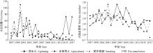
图1
黑龙江省3种火源引发的森林火灾次数和面积在1997—2017年间的年际变化"
图2
黑龙江省3种火源引发的森林火灾次数和面积在1997—2017年的季节变化"
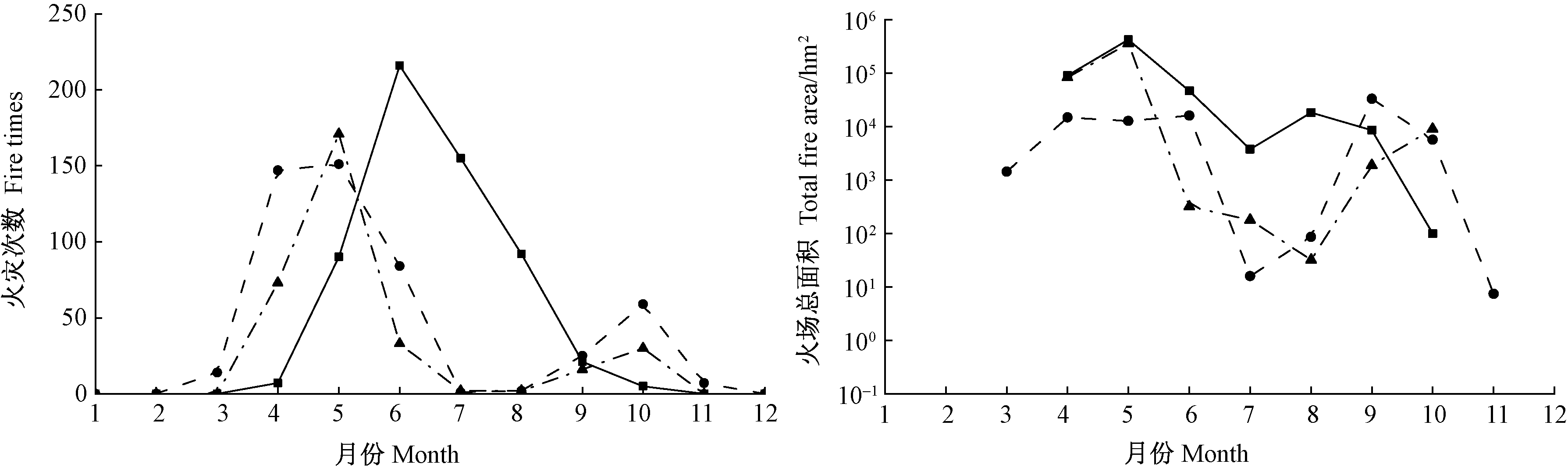
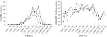
图3
黑龙江省3种火源引发的森林火灾次数和面积在1997—2017年间的日变化"

表1
3种火源对森林火场总面积影响的月份、时刻及其交互作用的差异"
| 参数 Parameter | 雷击火Lightning | 农事用火Agricultural | 野外吸烟Smoking | ||||||||
| F | df | P | F | df | P | F | df | P | |||
| 月份 Month | 3.99 | 6 | 0.00 | 13.66 | 7 | 0.00 | 0.73 | 6 | 0.63 | ||
| 时刻 Time | 3.31 | 17 | 0.00 | 11.99 | 19 | 0.00 | 0.59 | 14 | 0.87 | ||
| 月份×时刻 Month×Time | 2.52 | 53 | 0.00 | 8.63 | 53 | 0.00 | 0.87 | 36 | 0.69 | ||
表2
雷击火和农事用火在不同月份的不同时刻造成火场总面积的简单效应分析"
| 参数Parameter | F | df | P |
| 雷击火Lightning | |||
| 时刻×月份(9月)Time×Month(September) | 2.71 | 5 | 0.00 |
| 农事用火Agricultural 时刻×月份(6月)Time×Month(June) | 11.41 | 11 | 0.00 |
| 时刻×月份(9月)Time×Month(September) | 33.63 | 4 | 0.00 |
表3
雷击火和农事用火不同时刻造成火场总面积的差异性分析①"
| 时刻 Time | 农事用火(6月) Agricultural(June) | 农事用火(9月) Agricultural(September) | 雷击火(9月) Lightning(September) |
| 7:00—7:59 | 27.40±6.91 b | — | — |
| 8:00—8:59 | 81.00±72.12 b | — | — |
| 9:00—9:59 | 79.25±103.23 b | — | — |
| 10:00—10:59 | 286.92±527.44 b | — | — |
| 11:00—11:59 | 90.75±126.22 b | — | — |
| 12:00—12:59 | 1 666.67±992.89 a | 271.00±315.83 b | 19.53±15.40 b |
| 13:00—13:59 | 53.53±59.63 b | 34.90±54.67 b | 18.87±27.71 b |
| 14:00—14:59 | 43.06±48.13 b | 30.20±33.11 b | 4.08±4.50 b |
| 15:00—15:59 | 47.22±41.25 b | 449.98±687.92 b | 8.20±11.31 b |
| 16:00—16:59 | 146.44±228.48 b | 2 833.75±2014.17 a | 882.00±696.96 a |
| 17:00—17:59 | 58.75±30.65 b | — | 5.55±7.71 b |
| 22:00—22:59 | 130.00±113.14 b | — | — |
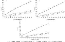
图4
1997—2011年黑龙江省3种火源的空间分布格局 a. 野外吸烟; b. 农事用火; c. 雷击火。"
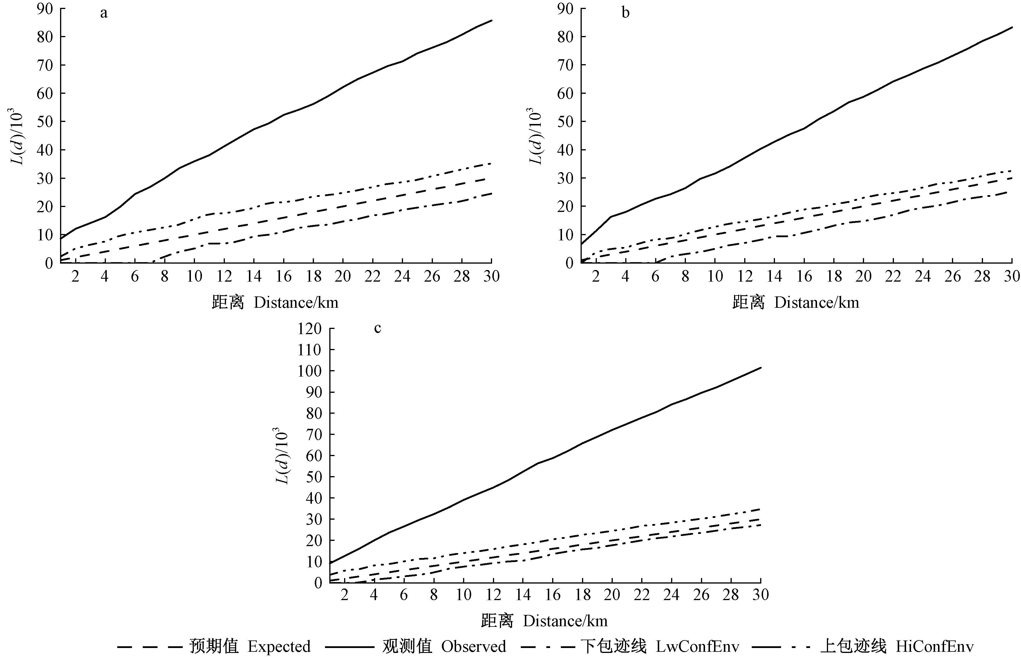
表4
1997—2017年黑龙江省农事用火火源引起的森林火灾次数和面积的空间分布①"
| 地区 Area | 火灾次数 Fire times | 火场总面积 Total fire area/hm2 |
| 嫩江县 Nenjiang County | 73 | 14 332.63 |
| 黑河市市辖区 Heihe municipal district | 55 | 17 248.50 |
| 孙吴县 Sunwu County | 40 | 20 606.30 |
| 逊克县 Xunke County | 31 | 11 802.67 |
| 五大连池市 Wudalianchi City | 29 | 7 639.67 |
| 宝清县 Baoqing County | 17 | 76.20 |
| 双鸭山市市辖区 Shuangyashan municipal district | 16 | 10.36 |
| 伊春市市辖区 Yichun municipal district | 14 | 218.00 |
| 七台河市市辖区 Qitaihe municipal district | 13 | 111.09 |
| 北安市 Bei’an City | 12 | 491.94 |
| 穆棱市 Muling City | 11 | 213.65 |
| 饶河县 Raohe County | 11 | 487.74 |
| 尚志市 Shangzhi City | 11 | 42.03 |
| 嘉荫县 Jiayin County | 10 | 488.05 |
| 韩家园林业局 Hanjiayuan Forestry Bureau | 9 | 110.30 |
| 牡丹江市市辖区 Mudanjiang municipal district | 9 | 35.39 |
| 桦南县 Huanan County | 9 | 5 181.21 |
| 密山市 Mishan City | 8 | 234.80 |
| 林口县 Linkou County | 8 | 33.41 |
| 虎林市 Hulin City | 8 | 88.29 |
| 集贤县 Jixian County | 7 | 4.00 |
| 铁力市 Tieli City | 6 | 57.80 |
| 东宁县 Dongning County | 6 | 182.16 |
| 勃利县 Boli County | 5 | 76.23 |
| 方正县 Fangzheng County | 5 | 2.67 |
| 鸡东县 Jidong County | 5 | 44.80 |
| 宁安市 Ning’an City | 5 | 28.00 |
| 松岭林业局 Songling Forestry Bureau | 5 | 238.30 |
表5
1997—2017年黑龙江省野外吸烟火源引起的森林火灾次数和面积的空间分布"
| 地区 Area | 火灾次数 Fire times | 火场总面积 Total fire area/hm2 |
| 嘉荫县 Jiayin County | 58 | 65 197.19 |
| 伊春市市辖区 Yichun municipal district | 40 | 1 657.37 |
| 加格达奇林业局 Jiagedaqi Forestry Bureau | 28 | 24 434.60 |
| 韩家园林业局 Hanjiayuan Forestry Bureau | 25 | 1 763.61 |
| 七台河市市辖区 Qitaihe municipal district | 18 | 36.39 |
| 逊克县 Xunke County | 15 | 3 142.70 |
| 嫩江县 Nenjiang County | 13 | 292.05 |
| 黑河市市辖区 Heihe municipal district | 12 | 26 446.00 |
| 萝北县 Luobei County | 10 | 145.80 |
| 孙吴县 Sunwu County | 8 | 962.30 |
| 呼玛县林业局 Forestry Bureau of Huma County | 7 | 1 241.10 |
| 桦南县 Huanan County | 7 | 96.50 |
| 塔河林业局 Tahe Forestry Bureau | 7 | 695.80 |
| 汤原县 Tangyuan County | 7 | 121.88 |
| 松岭林业局 Songling Forestry Bureau | 6 | 1 835.07 |
| 方正县 Fangzheng County | 5 | 40.60 |
| 海林市 Hailin City | 5 | 37.11 |
| 虎林市 Hulin City | 5 | 33.50 |
| 五大连池市 Wudalianchi City | 5 | 436.59 |
| 鸡东县 Jidong County | 4 | 84.50 |
| 铁力市 Tieli City | 4 | 13.00 |
| 依兰县 Yilan County | 4 | 17.17 |
表6
1997—2017年黑龙江省大兴安岭地区雷击火火源引起的森林火灾次数和面积的空间分布"
| 地区 Area | 火灾次数 Fire times | 火场总面积 Total fire area/hm2 |
| 呼中林业局 Huzhong Forestry Bureau | 93 | 23 210.42 |
| 西林吉林业局 Xilinji Forestry Bureau | 78 | 10 096.04 |
| 新林林业局 Xinlin Forestry Bureau | 64 | 1 423.36 |
| 塔河林业局 Tahe Forestry Bureau | 52 | 6 402.11 |
| 松岭林业局 Songling Forestry Bureau | 46 | 230 264.68 |
| 韩家园林业局 Hanjiayuan Forestry Bureau | 40 | 2 673.06 |
| 十八站林业局 Shibazhan Forestry Bureau | 40 | 6 851.75 |
| 阿木尔林业局 Amuer Forestry Bureau | 39 | 179.40 |
| 图强林业局 Tuqiang Forestry Bureau | 36 | 260.01 |
| 加格达奇林业局 Jiagedaqi Forestry Bureau | 21 | 4 644.32 |
| 呼中自然保护区 Huzhong Nature Reserve | 18 | 4 636.98 |
| 南翁河自然保护区 Nanwenghe Nature Reserve | 16 | 1 812.20 |
| 呼玛县林业局 Forestry Bureau of Huma County | 12 | 1 672.55 |
|
白世红, 马风云, 董金伟. 山东省森林火火源的时空分布. 山东林业科技, 2017, 47 (5): 6- 10.
doi: 10.3969/j.issn.1002-2724.2017.05.002 |
|
|
Bai S H , Ma F Y , Dong J W . Temporal and spatial distribution of forest fire cause in Shandong Province. Shandong Forestry Science and Technology, 2017, 47 (5): 6- 10.
doi: 10.3969/j.issn.1002-2724.2017.05.002 |
|
|
车旺, 杜嘉林. 黑龙江省林火扑救费用及趋势分析. 林业勘查设计, 2018, (1): 80- 82.
doi: 10.3969/j.issn.1673-4505.2018.01.038 |
|
|
Che W , Du J L . Forest fire extinguishing costs and trend analysis in Heilongjiang Province. Forest Investigation Design, 2018, (1): 80- 82.
doi: 10.3969/j.issn.1673-4505.2018.01.038 |
|
| 杜春英, 李帅, 刘丹, 等. 大兴安岭地区森林雷击火发生的时空分布. 自然灾害学报, 2010, 19 (3): 72- 76. | |
| Du C Y , Li S , Liu D , et al. Spatiotemporal distribution of lightning-caused forest fires in Daxinganling area. Journal of Natural Disasters, 2010, 19 (3): 72- 76. | |
|
郭福涛, 胡海清, 马志海. 应用空间点模式方法研究大兴安岭雷击火空间分布格局. 生态学报, 2009, 29 (12): 6741- 6747.
doi: 10.3321/j.issn:1000-0933.2009.12.051 |
|
|
Guo F T , Hu H Q , Ma Z H . Spatial point process for spatial distribution pattern of lightning-caused forest fires in Daxing'an Mountains. Acta Ecologica Sinica, 2009, 29 (12): 6741- 6747.
doi: 10.3321/j.issn:1000-0933.2009.12.051 |
|
| 霍玉盛. 2018. 黑龙江省土地综合承载力评价研究. 沈阳: 东北农业大学硕士学位论文. | |
| Huo Y S. 2018. Study on the land comprehensive carrying capacity evaluation in Heilongjiang Province. Harbin: PhD Northeast Agricultural University. [in Chinese] | |
| 金森, 胡海清. 黑龙江省林火规律研究Ⅰ. 林火时空动态与分布. 林业科学, 2002, 38 (1): 88- 94. | |
| Jin S , Hu H Q . Study on forest fire regime of Heilongjiang ProvinceⅠ. Forest fire spatial and temporal dynamics and statistical distribution. Scientia Silvae Sinicae, 2002, 38 (1): 88- 94. | |
| 李小川, 李兴伟, 王振师, 等. 广东森林火灾的火源特点分析. 中南林业科技大学学报, 2008, 28 (1): 89- 92. | |
| Li X C , Li X W , Wang Z S , et al. Analysis of fire source characteristics of Guangdong forest fires. Journal of Central South University of Forestry & Technology, 2008, 28 (1): 89- 92. | |
| 林花明. 福建省森林火灾发生和火源时空分布规律研究. 林业勘察设计, 2017, 37 (3): 10- 12. | |
| Lin H M . Study on the occurrence of forest fires and the temporal and spatial distribution of fire caused in Fujian Province. Forestry Prospect and Design, 2017, 37 (3): 10- 12. | |
| 刘琳, 钟红银, 杨春华, 等. 不同刈割时期和强度对改良草地老芒麦产量、品质及再生植株生殖特征的影响. 草地学报, 2017, 25 (5): 1131- 1137. | |
| Liu L , Zhong H Y , Yang C H , et al. Effects of different cutting time and intensities on forage yield, quality and reproductive characteristics of regrowth individuals of E. sibiricus. Acta Agrestia Sinicae, 2017, 25 (5): 1131- 1137. | |
|
龙腾腾, 高仲亮, 王秋华. 云南省森林火源特点分析. 安徽农业科学, 2017, 45 (32): 165- 166.
doi: 10.3969/j.issn.0517-6611.2017.32.052 |
|
|
Long T T , Gao Z L , Wang Q H . Analysis on the characteristics of forest fire sources in Yunnan Province. Journal of Anhui Agricultural Sciences, 2017, 45 (32): 165- 166.
doi: 10.3969/j.issn.0517-6611.2017.32.052 |
|
|
舒立福, 王明玉, 田晓瑞, 等. 我国大兴安岭呼中林区雷击火发生火环境研究. 林业科学, 2003, 39 (6): 94- 99.
doi: 10.3321/j.issn:1001-7488.2003.06.016 |
|
|
Shu L F , Wang M Y , Tian X R , et al. The fire environment mechanism of lightning fire formed for Daxing'an mountains. Scientia Silvae Sinicae, 2003, 39 (6): 94- 99.
doi: 10.3321/j.issn:1001-7488.2003.06.016 |
|
|
宋国忠, 王炜烨. 黑龙江省森林火灾发生规律及防火工作策略研究. 森林防火, 2018, (3): 17- 19.
doi: 10.3969/j.issn.1002-2511.2018.03.005 |
|
|
Song G Z , Wang W Y . Study on the law of forest fire occurrence and fire prevention strategy in Heilongjiang Province. Forest Fire Prevenion, 2018, (3): 17- 19.
doi: 10.3969/j.issn.1002-2511.2018.03.005 |
|
| 孙玉荣, 张贵. 湖南省森林火灾人为火源时空分布特征. 中国农学通报, 2011, 27 (28): 103- 108. | |
| Sun Y R , Zhang G . Characteristics of the spatial-temporal distribution for artificial fire caused on forest fires in Hunan. Chinese Agricultural Science Bulletin, 2011, 27 (28): 103- 108. | |
|
王波, 王莹, 李永生. 黑龙江省降雪气候变化特征. 中国农学通报, 2019, 35 (10): 114- 120.
doi: 10.11924/j.issn.1000-6850.casb18110002 |
|
|
Wang B , Wang Y , Li Y S . Snowfall in Heilongjiang: climatic change characteristics. Chinese Agricultural Science Bulletin, 2019, 35 (10): 114- 120.
doi: 10.11924/j.issn.1000-6850.casb18110002 |
|
| 尹赛男, 宋光辉, 单延龙, 等. 吉林省主要森林火灾火源的空间分布. 东北林业大学学报, 2019, 47 (3): 79- 84. | |
| Yin S N , Song G H , Shan Y L , et al. Spatial distribution analysis of main forest fire sources in Jilin Province. Journal of Northeast Forestry University, 2019, 47 (3): 79- 84. | |
| 尹赛男, 舒立福, 张大明, 等. 吉林省森林火灾火源数据特征分析. 林业科学, 2018, 54 (7): 165- 172. | |
| Yin S N , Shu L F , Zhang D M , et al. Study on the data characteristics of forest fire sources in Jilin Province. Scientia Silvae Sinicae, 2018, 54 (7): 165- 172. | |
| 张冬有, 邓欧, 李亦秋, 等. 黑龙江省1980-2005年森林火灾时空特征. 林业科学, 2012, 48 (2): 175- 179. | |
| Zhang D Y , Deng O , Li Y Q , et al. Temporal and spatial characteristics of forest fires in Heilongjiang Province between 1980 and 2005. Scientia Silvae Sinicae, 2012, 48 (2): 175- 179. | |
| 张巍, 颜廷强, 王志成. 黑龙江省雷击森林火灾时空分布特点. 林业建设, 2018, (3): 31- 34. | |
| Zhang W , Yan T Q , Wang Z C . Characteristics of spatial and temporal distribution on lightning forest fire in Heilongjiang Province. Forestry Construction, 2018, (3): 31- 34. | |
| 张玉红. 黑龙江省森林火灾的时空分布. 哈尔滨师范大学自然科学学报, 2002, 18 (5): 95- 100. | |
| Zhang Y H . The spatio-temporal distribution of forest fire in Heilongjiang. Natural Sciences Journal of Harbin Normal University, 2002, 18 (5): 95- 100. | |
| 郑焕能. 林火管理. 哈尔滨: 东北林业大学出版社, 1988: 27- 34. | |
| Zheng H N . Forest fire management. Harbin: Northeast Forestry University Press, 1988: 27- 34. | |
| 郑宏, 王英博. 关于黑龙江省森林火灾预防与扑救的几点思考. 防护林科技, 2017, (6): 89- 90. | |
| Zheng H , Wang Y B . Thoughts on forest fire prevention and fighting in Heilongjiang Province. Protection Forest Science and Technology, 2017, (6): 89- 90. | |
| Besag J E . Comments on Ripley's paper. Journal of Royal Statistic Society, 1977, 39, 193- 195. | |
| Butry D T , Prestemon J P , Thomas D S . Investigation of the decline in reported smoking-caused wildfires in the USA from 2000 to 2011. International Journal of Wildland Fire, 2014, 23 (7): 790- 798. | |
| Carlos D A , Peterson D L , Alvarado E , et al. Space-time modelling of lightning-caused ignitions in the Blue Mountains, Oregon. Canadian Journal of Forest Research, 2001, 31 (9): 1579- 1593. | |
|
Flannigan M D , Stocks B J , Wotton B M . Climate change and forest fires. Science of the Total Environment, 2000, 262 (3): 221- 229.
doi: 10.1016/S0048-9697(00)00524-6 |
|
|
Genton M G , Butry D T , Gumpertz M L , et al. Spatio-temporal analysis of wildfire ignitions in the St Johns River Water Management District, Florida. International Journal of Wildland Fire, 2006, 15 (1): 87- 97.
doi: 10.1071/WF04034 |
|
|
Laona D W , Chapin F S . Human impacts on the fire regime of Interior Alaska: Interactions among fuels, ignition sources, and fire suppression. Ecosystems, 2006, 9 (8): 1342- 1353.
doi: 10.1007/s10021-006-0095-0 |
|
|
Narayanaraj G , Wimberly M C . Influences of forest roads on the spatial patterns of human- and lightning-caused wildfire ignitions. Applied Geography, 2012, 32 (2): 878- 888.
doi: 10.1016/j.apgeog.2011.09.004 |
|
|
Nicolas F , Yu J , Goulden M L , et al. Controls on the spatial pattern of wildfire ignitions in Southern California. International Journal of Wildland Fire, 2014, 23 (6): 799- 815.
doi: 10.1071/WF13136 |
|
|
Podur J , Martell D L , Csillag F . Spatial patterns of lightning-caused forest fires in Ontario, 1976-1998. Ecological Modelling, 2003, 164 (1): 1- 20.
doi: 10.1016/S0304-3800(02)00386-1 |
|
| Read N , Duff T J , Taylor P G . A lightning-caused wildfire ignition forecasting model for operational use. Agricultural and Forest Meteorology, 2018, 253, 233- 246. | |
|
Ripley B D . Modelling spatial patterns. Journal of the Royal Statistical Society, Series B (Methodological), 1977, 39 (2): 172- 212.
doi: 10.1111/j.2517-6161.1977.tb01615.x |
|
|
Rorig M L , Ferguson S A . Characteristics of lightning and wildland fire ignition in the Pacific Northwest. Journal of Applied Meteorology, 1999, 38 (11): 1565- 1575.
doi: 10.1175/1520-0450(1999)038<1565:COLAWF>2.0.CO;2 |
|
|
Wang Y , Anderson K R . An evaluation of spatial and temporal patterns of lightning- and human-caused forest fires in Alberta, Canada, 1980-2007. International Journal of Wildland Fire, 2010, 19 (8): 1059- 1072.
doi: 10.1071/WF09085 |
|
|
Wittenberg L , Malkinson D . Spatio-temporal perspectives of forest fires regimes in a maturing Mediterranean mixed pine landscape. European Journal of Forest Research, 2009, 128 (3): 297- 304.
doi: 10.1007/s10342-009-0265-7 |
|
|
Ye J , Wu M , Deng Z , et al. Modeling the spatial patterns of human wildfire ignition in Yunnan Province, China. Applied Geography, 2017, 89, 150- 162.
doi: 10.1016/j.apgeog.2017.09.012 |
| [1] | 袭月,张志强,周洁,王丽群,陈立欣. 城市化进程下地表温度时空变化及其与植被覆盖度的相关性——以北京五环区域为例[J]. 林业科学, 2021, 57(6): 1-13. |
| [2] | 孙涛,贾志清,刘虎俊,尚雯,刘江,张立恒. 民勤荒漠绿洲过渡带不同发育阶段白刺灌丛沙堆点格局特征[J]. 林业科学, 2020, 56(7): 12-21. |
| [3] | 王锋, 卢琦. 沙地樟子松散生单木的天然更新幼苗空间分布模型[J]. 林业科学, 2019, 55(8): 1-8. |
| [4] | 古琳, 王成, 王艳英, 王晓磊, 孙振凯, 王茜, 孙睿霖. 惠山国家森林公园游憩林小气候与人体舒适度变化规律[J]. 林业科学, 2019, 55(6): 150-159. |
| [5] | 董灵波,王鹤智,刘兆刚. 凉水自然保护区森林类型斑块的空间格局及关联性动态[J]. 林业科学, 2019, 55(10): 138-151. |
| [6] | 王金龙, 杨伶, 张贵, 尹少华. 基于空间网络的湖南“森林生态·经济·社会”复合系统空间格局演变分析[J]. 林业科学, 2018, 54(7): 118-129. |
| [7] | 尹赛男, 舒立福, 张大明, 单延龙, 杜帅, 唐抒圆, 张鑫瑶, 张志文. 吉林省森林火灾火源数据特征分析[J]. 林业科学, 2018, 54(7): 165-172. |
| [8] | 翟婉璐, 钟哲科, 高贵宾, 杨慧敏. 覆盖经营对雷竹林土壤细菌群落结构演变及多样性的影响[J]. 林业科学, 2017, 53(9): 133-142. |
| [9] | 马志波, 黄清麟, 庄崇洋, 郑群瑞, 王宏. 典型中亚热带天然阔叶林群落各乔木亚层的空间格局与关联性[J]. 林业科学, 2017, 53(12): 12-19. |
| [10] | 欧朝蓉, 朱清科, 孙永玉. 元谋干热河谷旱季植被覆盖度的时空异质性[J]. 林业科学, 2017, 53(11): 20-28. |
| [11] | 刘琳, 刘铁男, 刘美爽, 刘俊昌. 黑龙江省森工林区林业用地面积变化及驱动因素分析[J]. 林业科学, 2016, 52(5): 160-169. |
| [12] | 王梅, 赵晨光, 王莹, 楚光明. 盐穗木种群空间点格局对地下水埋深的响应[J]. 林业科学, 2015, 51(11): 17-24. |
| [13] | 王云霓, 曹恭祥, 王彦辉, 熊伟, 于澎涛, 徐丽宏. 宁夏六盘山华北落叶松人工林植被碳密度特征[J]. 林业科学, 2015, 51(10): 10-16. |
| [14] | 楚光明, 王梅, 张硕新. 准噶尔盆地南缘洪积扇无叶假木贼种群空间点格局[J]. 林业科学, 2014, 50(4): 8-14. |
| [15] | 张冬有;邓欧;李亦秋;李桂君;冯仲科. 黑龙江省1980—2005年森林火灾时空特征[J]. 林业科学, 2012, 48(2): 175-179. |
| 阅读次数 | ||||||
|
全文 |
|
|||||
|
摘要 |
|
|||||