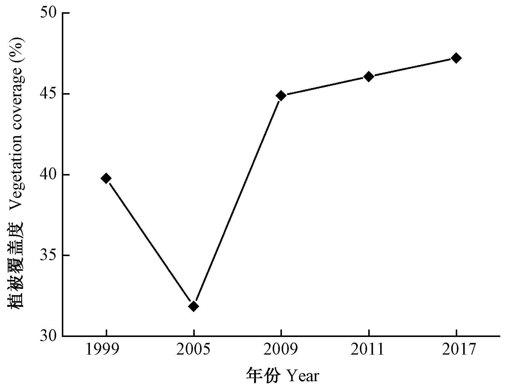
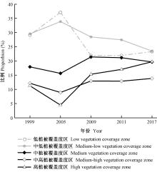
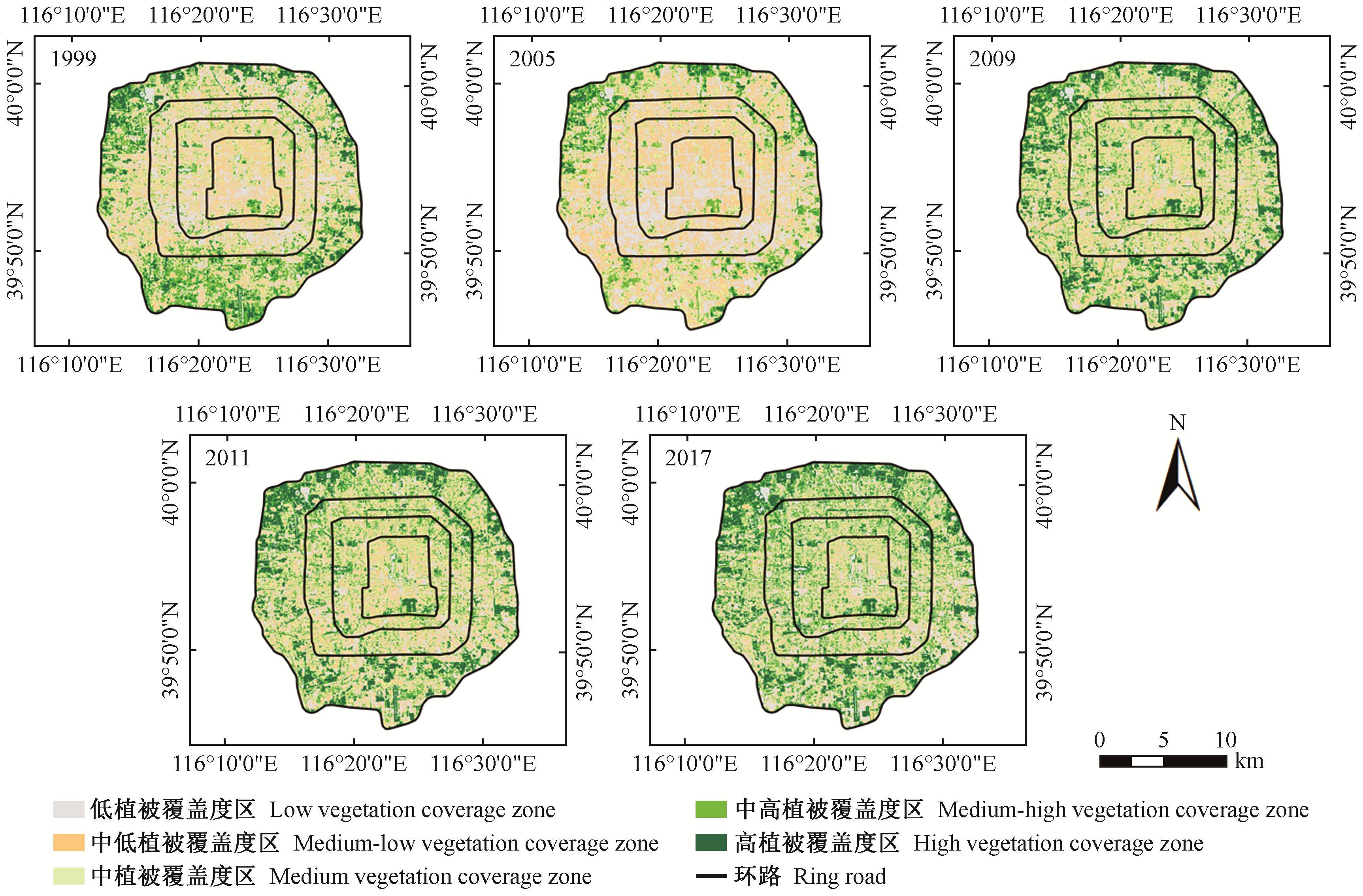
|
崔凤娇, 邵锋, 齐锋, 等. 植被对城市热岛效应影响的研究进展. 浙江农林大学学报, 2020, 7 (1): 171- 181.
|
|
Cui F J , Shao F , Qi F , et al. Research progress on the influence of vegetation on urban heat island effect. Journal of Zhejiang A & F University, 2020, 7 (1): 171- 181.
|
|
杜红玉. 2018. 特大型城市"蓝绿空间"冷岛效应及其影响因素研究——以上海市为例. 上海: 华东师范大学博士学位论文.
|
|
Du H Y. 2018. Study on the cold island effect of "blue-green space" and its influencing factors in super large cities: a case study of Shanghai. Shanghai: PhD thesis of East China Normal University. [in Chinese]
|
|
葛荣凤, 王京丽, 张力小, 等. 北京市城市化进程中热环境响应. 生态学报, 2016, 36 (19): 6040- 6049.
|
|
Ge R F , Wang J L , Zhang L X , et al. Thermal environment response in the process of urbanization in Beijing. Acta Ecologica Sinica, 2016, 36 (19): 6040- 6049.
|
|
刘海轩, 许丽娟, 吴鞠, 等. 城市森林降温效应影响因素研究进展. 林业科学, 2019, 55 (4): 144- 151.
|
|
Liu H X , Xu L J , Wu J , et al. Research progress on factors affecting the cooling effect of urban forest. Scientia Silvae Sinicae, 2019, 55 (4): 144- 151.
|
|
秦仲, 李湛东, 成仿云, 等. 北京园林绿地5种植物群落夏季降温增湿作用. 林业科学, 2016, 52 (1): 37- 47.
|
|
Qin Z , Li Z D , Cheng F Y , et al. Cooling and humidifying effect of five plant communities in Beijing garden green area in summer. Scientia Silvae Sinicae, 2016, 52 (1): 37- 47.
|
|
王文杰, 申文明, 刘晓曼, 等. 基于遥感的北京市城市化发展与城市热岛效应变化关系研究. 环境科学研究, 2006, 19 (2): 44- 48.
doi: 10.3321/j.issn:1001-6929.2006.02.014
|
|
Wang W J , Shen W M , Liu X M , et al. Study on the relationship between urbanization development and urban heat island effect based on remote sensing in Beijing. Environmental Science Research, 2006, 19 (2): 44- 48.
doi: 10.3321/j.issn:1001-6929.2006.02.014
|
|
徐涵秋. 基于城市地表参数变化的城市热岛效应分析. 生态学报, 2011, 31 (14): 3890- 3901.
|
|
Xu H Q . Analysis on urban heat island effect based on the dynamics of urban surface biophysical descriptors. Acta Ecologica Sinica, 2011, 31 (14): 3890- 3901.
|
|
杨宇翀, 林箐, 岳晓蕾. 区域和城市尺度下的城市森林冷岛效应——以北京市五环内为例. 北京规划建设, 2018, 20 (5): 93- 96.
|
|
Yang Y C , Lin J , Yue X L . Urban forest cold island effect at regional and urban scales: a case study within fifth ring road in Beijing. Beijing Planning and Construction, 2018, 20 (5): 93- 96.
|
|
Akbari H , Rose L S . Urban surfaces and heat island mitigation potentials. Journal of the Human-Environment System, 2008, 11 (2): 85- 101.
doi: 10.1618/jhes.11.85
|
|
Alavipanah S , Wegman M , Qureshi S , et al. The role of vegetation in mitigating urban land surface temperatures: a case study of Munich, Germany during the warm season. Sustainability, 2015, 7 (4): 4689- 4706.
doi: 10.3390/su7044689
|
|
Bek M A , Azmy N , Elkafrawy S . The effect of unplanned growth of urban areas on heat island phenomena. Ain Shams Engineering Journal, 2018, 9 (4): 3169- 3177.
doi: 10.1016/j.asej.2017.11.001
|
|
Best M J , Grimmond C S B . Investigation of the impact of anthropogenic heat flux within an urban land surface model and PILPS-urban. Theoretical and Applied Climatology, 2016, 126 (1/2): 51- 60.
|
|
Berry R , Livesley S J , Aye L . Tree canopy shade impacts on solar irradiance received by building walls and their surface temperature. Building and Environment, 2013, 69 (11): 91- 100.
|
|
Cao W , Huang L , Liu L L , et al. Overestimating impacts of urbanization on regional temperatures in developing megacity: Beijing as an example. Advances in Meteorology, 2019, (2): 3985715.
|
|
Carlson T N , Arthur S T . The impact of land use-land cover changes due to urbanization on surface microclimate and hydrology: a satellite perspective. Global and Planetary Change, 2000, 25 (1): 49- 65.
|
|
Chen W , Zhang Y , Yu C , et al. Evaluation of urbanization dynamics and its impacts on surface heat islands: a case study of Beijing, China. Remote Sensing, 2017, 9 (5): 453.
doi: 10.3390/rs9050453
|
|
Chen Y H , Cai Y B , Tong C . Quantitative analysis of urban cold island effects on the evolution of green spaces in a coastal city: a case study of Fuzhou, China. Environmental Monitoring and Assessment, 2019, 191 (1): 121.
doi: 10.1007/s10661-019-7213-x
|
|
Chun B , Guldmann J M . Spatial statistical analysis and simulation of the urban heat island in high-density central cities. Landscape and Urban Planning, 2014, 125 (3): 76- 88.
|
|
Du Y , Xie Z Q , Zeng Y , et al. Impact of urban expansion on regional temperature change in the Yangtze River Delta. Journal of Geographical Sciences, 2007, 17 (4): 387- 398.
doi: 10.1007/s11442-007-0387-0
|
|
Duncan J M A , Boruff B , Saunders A , et al. Turning down the heat: an enhanced understanding of the relationship between urban vegetation and surface temperature at the city scale. Science of the Total Environment, 2019, 656 (3): 118- 128.
|
|
Estoque R C , Murayama Y . Classification and change detection of built-up lands from landsat-7 ETM+ and landsat-8 OLI/TIRS imageries: a comparative assessment of various spectral indices. Ecological Indicators, 2017, 56, 205- 217.
|
|
Guo L J , Liu R M , Men C , et al. Quantifying and simulating landscape composition and pattern impacts. Science of the Total Environment, 2019a, 654 (3): 430- 440.
|
|
Guo M H , Chen S H , Wang W M , et al. Spatiotemporal variation of heat fluxes in Beijing with land use change from 1997 to 2017. Physics and Chemistry of the Earth, 2019b, 110 (4): 51- 60.
|
|
Gago E J , Roldán J , Pacheco T R , et al. The city and urban heat islands: a review of strategies to mitigate adverse effects. Renewable and Sustainable Energy Reviews, 2013, 25 (9): 749- 758.
|
|
Gill S E , Rahman M A , Handley J F , et al. Modelling water stress to urban amenity grass in Manchester UK under climate change and its potential impacts in reducing urban cooling. Urban Forestry & Urban Greening, 2013, 12 (3): 350- 358.
|
|
Grimm N B , Faeth S H , Golubiewski N E , et al. Global change and the ecology of cities. Science, 2008, 319 (5864): 756- 760.
doi: 10.1126/science.1150195
|
|
Jenerette G D , Harlan S L , Stefanov W L , et al. Ecosystem services and urban heat riskscape moderation: water, green spaces, and social inequality in Phoenix, USA. Ecological Applications, 2011, 21 (7): 2637- 2651.
doi: 10.1890/10-1493.1
|
|
Khamchiangta D , Dhaka S . Physical and non-physical factors driving urban heat island: case of Bangkok Metropolitan Administration, Thailand. Journal of Environmental Management, 2019, 248 (10): 109285.
|
|
Lau S S , Lin P , Qin H . A preliminary study on environmental performances of pocket parks in high-rise and high-density urban context in HongKong. International Journal of Low-Carbon Technologies, 2012, 7 (3): 215- 225.
doi: 10.1093/ijlct/cts033
|
|
Lee S H , Lee K S , Jin W C , et al. Effect of an urban park on air temperature differences in a central business district area. Landscape and Ecological Engineering, 2009, 5 (2): 183- 191.
doi: 10.1007/s11355-009-0067-6
|
|
Li X M , Zhou W Q , Ouyang Z Y , et al. Spatial pattern of green space affects land surface temperature: Evidence from the heavily urbanized Beijing metropolitan area, China. Landscape Ecology, 2012, 27 (6): 887- 898.
doi: 10.1007/s10980-012-9731-6
|
|
Luo X , Peng Y . Scale effects of the relationships between urban heat islands and impact factors based on a geographically-weighted regression model. Remote Sensing, 2016, 8 (9): 760- 769.
doi: 10.3390/rs8090760
|
|
Ma Y , Kuang Y , Huang N . Coupling urbanization analyses for studying urban thermal environment and its interplay with biophysical parameters based on TM/ETM + imagery. International Journal of Applied Earth Observation and Geoinformation, 2010, 12 (2): 110- 118.
doi: 10.1016/j.jag.2009.12.002
|
|
Min M , Lin C , Duan X J . Spatial distribution and driving force analysis of urban heat island effect based on raster data: a case study of the Nanjing metropolitan area, China. Sustainable Cities and Society, 2019, 50 (10): 101637.
|
|
Naeem S , Cao C X , Fatima K , et al. Landscape greening policies-based land use/land cover simulation for Beijing and islamabad: an implication of sustainable urban ecosystems. Sustainability, 2018, 10 (4): 1049.
doi: 10.3390/su10041049
|
|
Ng E , Chen L , Wang Y , et al. A study on the cooling effects of greening in a high-density city: an experience from Hong Kong. Building and Environment, 2012, 47 (1): 256- 271.
|
|
Oliveira S , Andrade H , Vaz T . The cooling effect of green spaces as a contribution to the mitigation of urban heat: a case study in Lisbon. Building and Environment, 2011, 46 (11): 2186- 2194.
doi: 10.1016/j.buildenv.2011.04.034
|
|
Qiu G Y , Li H Y , Zhang Q T , et al. Effects of evapotranspiration on mitigation of urban temperature by vegetation and urban agriculture. Journal of Integrative Agriculture, 2013, 12 (8): 1307- 1315.
doi: 10.1016/S2095-3119(13)60543-2
|
|
Ren C , Yang R Z , Cheng C , et al. Creating breathing cities by adopting urban ventilation assessment and wind corridor plan: the implementation in Chinese cities. Journal of Wind Engineering and Industrial Aerodynamics, 2018, 182 (11): 170- 188.
|
|
Sun R H , Chen L D . Effects of green space dynamics on urban heat islands: Mitigation and diversification. Ecosystem Services, 2017, 23 (2): 38- 46.
|
|
Taha H , Douglas S , Haney J . Urban climates and heat islands: albedo, evapotranspiration, and anthropogenic heat. Energy and Buildings, 1997, 25 (2): 99- 103.
doi: 10.1016/S0378-7788(96)00999-1
|
|
Wang Y , Berardi U , Akbari H . Comparing the effects of urban heat island mitigation strategies for Toronto, Canada. Energy and Buildings, 2016, 114 (2): 2- 19.
|
|
Yao R , Wang L C , Huang X , et al. Temporal trends of surface urban heat islands and associated determinants in major Chinese cities. Science of the Total Environment, 2017, 609 (12): 742- 754.
|
|
Yu Z W , Yao Y W , Yang G Y , et al. Strong contribution of rapid urbanization and urban agglomeration development to regional thermal environment dynamics and evolution. Forest Ecology and Management, 2019, 446 (8): 214- 225.
|
|
Zhang X Y , Zhong T Y , Feng X Z , et al. Estimation of the relationship between vegetation patches and urban land surface temperature with remote sensing. International Journal of Remote Sensing, 2009, 30 (4): 2105- 2118.
|
|
Zhou D C , Zhao S Q . Surface urban heat island in China's 32 major cities: spatial patterns and drivers. Remote Sensing of Environment, 2014, 152 (9): 51- 61.
|
|
Ziter C D , Pedersen E J , Kucharik C J , et al. Scale-dependent interactions between tree canopy cover and impervious surfaces reduce daytime urban heat during summer. PNAS, 2019, 116 (2): 7575- 7580.
|