
林业科学 ›› 2019, Vol. 55 ›› Issue (12): 1-11.doi: 10.11707/j.1001-7488.20191201
欧阳林男,陈少雄*,刘学锋,何沙娥,张维耀
收稿日期:2018-11-16
出版日期:2019-12-25
发布日期:2020-01-02
通讯作者:
陈少雄
基金资助:Linnan Ouyang,Shaoxiong Chen*,Xuefeng Liu,Sha He,Weiyao Zhang
Received:2018-11-16
Online:2019-12-25
Published:2020-01-02
Contact:
Shaoxiong Chen
Supported by:摘要:
目的: 采用MaxEnt模型对赤桉在中国的适生地理区域及其对气候变化的响应进行预测,分析影响赤桉分布的主要生态因子,为赤桉的推广种植提供理论依据。方法: 基于赤桉现有的分布数据,气候、土壤、地形因子数据以及政府间气候变化专门委员会第五次评估报告发布的气候模式数据,采用MaxEnt模型预测赤桉在当前气候和温室气体低、中、高3种浓度排放情景下2041—2060和2061—2080年代的潜在适生区,分析未来气候条件下赤桉适生面积和分布格局的变化趋势。比较生态因子在原产地澳大利亚自然分布区和中国最适生区之间的相似性,综合Jackknife检验结果、百分比贡献率、最适生区与原产地自然分布区生态因子相似性,探讨影响赤桉分布的主要环境因子。结果: 模型训练子集和测试子集的受试者操作特征曲线下的面积(AUC)分别为0.939和0.847,模拟精度较高;当前赤桉的最适生区主要集中在东南沿海丘陵、南岭山地和云贵高原西部,预测结果显示,未来不同气候情景下,到2070年赤桉最适生面积具有潜在的增大趋势,低温室气体浓度情景(RCP 2.6)下增幅最大,响应最敏感,东南沿海丘陵最适生区为纬度方向上的波动,南岭山地最适生区为内部扩张,云贵高原西部最适生区则是沿河流向低海拔地区扩张;Jackknife检验结果显示,最干季度平均气温、气温季节变化方差、最热月份最高气温、海拔、最热季度降水量、最热季度平均气温、年降水量、坡度、坡向、太阳辐射是影响赤桉分布的主要生态因子,累积贡献率达87.0%;中国最适生区的气温季节变化方差、最热月份最高气温、最热季度平均气温、海拔和坡向与原产地自然分布区相似。结论: 当前我国赤桉的最适地理区为东南沿海丘陵、南岭山地和云贵高原西部,未来气候情景下,赤桉可在这3个区域找到更多的适生环境。最干季平均气温、最热季平均气温、气温季节变化方差、最热月最高气温、最热季降水量、年均降水量、海拔、坡度、坡向和太阳辐射是制约赤桉分布的重要环境因子。与原产地自然分布区相比,我国最适生区的最热季度降水量和年降水量分别高2.24和2.10倍,有利于赤桉快速生长。
中图分类号:
欧阳林男,陈少雄,刘学锋,何沙娥,张维耀. 赤桉在中国的适生地理区域及其对气候变化的响应[J]. 林业科学, 2019, 55(12): 1-11.
Linnan Ouyang,Shaoxiong Chen,Xuefeng Liu,Sha He,Weiyao Zhang. Suitable Geographic Range for Eucalyptus camaldulensis in China and Its Response to Climate Change[J]. Scientia Silvae Sinicae, 2019, 55(12): 1-11.
表1
研究区样点分布"
| 省(区) Province(Region) | 经度 Longitude/(°E) | 纬度 Latitude/(°N) |
| 广西 Guangxi | 107.86 | 22.34 |
| 109.88 | 24.77 | |
| 109.25 | 23.77 | |
| 109.12 | 22.92 | |
| 107.83 | 22.55 | |
| 109.22 | 21.61 | |
| 110.92 | 25.67 | |
| 111.31 | 23.50 | |
| 广东 Guangdong | 109.79 | 20.96 |
| 110.23 | 21.12 | |
| 109.88 | 21.23 | |
| 110.15 | 21.65 | |
| 113.9 | 22.59 | |
| 114.22 | 22.72 | |
| 112.94 | 22.37 | |
| 113.21 | 23.40 | |
| 113.52 | 23.36 | |
| 113.62 | 23.29 | |
| 113.56 | 22.78 | |
| 111.54 | 21.68 | |
| 113.04 | 23.10 | |
| 112.66 | 22.98 | |
| 福建 Fujian | 117.78 | 24.76 |
| 117.65 | 24.24 | |
| 119.46 | 26.26 | |
| 118.95 | 25.86 | |
| 118.92 | 25.90 | |
| 118.58 | 25.93 | |
| 119.79 | 25.52 | |
| 117.36 | 25.94 | |
| 117.64 | 26.28 | |
| 117.32 | 26.05 | |
| 117.33 | 26.02 | |
| 117.44 | 25.81 | |
| 117.44 | 26.08 | |
| 117.12 | 25.74 | |
| 117.13 | 26.04 | |
| 117.25 | 25.86 | |
| 116.84 | 25.92 | |
| 116.63 | 26.38 | |
| 118.39 | 26.46 | |
| 117.69 | 27.07 | |
| 118.41 | 26.44 | |
| 119.99 | 26.88 | |
| 120.08 | 26.92 | |
| 116.61 | 25.15 | |
| 116.42 | 25.04 | |
| 118.7 | 25.37 | |
| 120.24 | 27.19 | |
| 120.13 | 27.14 | |
| 119.98 | 27.27 | |
| 海南 Hainan | 110.52 | 19.23 |
| 108.87 | 18.72 | |
| 109.68 | 19.91 | |
| 110.10 | 19.37 | |
| 云南 Yunnan | 101.75 | 25.84 |
| 101.83 | 25.82 | |
| 101.86 | 25.74 | |
| 101.87 | 25.77 | |
| 102.08 | 25.90 | |
| 101.23 | 25.48 | |
| 103.59 | 23.77 | |
| 103.41 | 24.41 | |
| 103.76 | 24.54 | |
| 103.24 | 23.70 | |
| 102.82 | 23.64 | |
| 102.49 | 23.71 | |
| 99.47 | 24.20 | |
| 103.01 | 26.39 | |
| 103.12 | 26.23 | |
| 102.75 | 25.06 | |
| 102.54 | 25.22 | |
| 102.09 | 25.16 | |
| 100.52 | 25.05 | |
| 江西 Jiangxi | 114.95 | 25.76 |
| 114.91 | 25.89 | |
| 115.92 | 26.18 | |
| 114.37 | 25.86 | |
| 114.51 | 28.35 | |
| 115.83 | 28.77 | |
| 115.26 | 27.45 | |
| 湖南 Hunan | 113.04 | 25.80 |
| 113.22 | 26.28 | |
| 113.68 | 25.54 | |
| 112.58 | 25.28 | |
| 112.95 | 25.39 | |
| 113.14 | 27.91 | |
| 111.64 | 25.44 | |
| 111.43 | 26.44 | |
| 111.38 | 26.44 | |
| 109.66 | 26.68 | |
| 112.6 | 26.90 | |
| 112.62 | 26.86 | |
| 四川 Sichuan | 102.71 | 27.07 |
| 102.88 | 26.96 | |
| 104.75 | 28.84 |
表2
各环境变量相对贡献率"
| 序号 No. | 环境变量 Environmental variable | 贡献率 Contribution (%) |
| 1 | 年均气温 Annual mean temperature | 1.2 |
| 2 | 气温季节变化方差 Seasonal temperature variance | 15.8 |
| 3 | 最热月份最高气温 Maximum temperature of the warmest month | 11.5 |
| 4 | 最湿季度平均气温 Mean temperature of the wettest quarter | 0.8 |
| 5 | 最干季度平均气温 Mean temperature of the driest quarter | 21.3 |
| 6 | 最热季度平均气温 Mean temperature of the warmest quarter | 5.7 |
| 7 | 最冷季度平均气温 Mean temperature of the coldest quarter | 2.5 |
| 8 | 年降水量 Annual precipitation | 4.0 |
| 9 | 降水量季节变化方差 Seasonal precipitation variance | 0.6 |
| 10 | 最湿季度降水量 Precipitation of the wettest quarter | 1.2 |
| 11 | 最热季度降水量 Precipitation of the warmest quarter | 7.0 |
| 12 | 土壤有效水含量 Soil available water content | 3.0 |
| 13 | 土壤阳离子交换量 Soil cation exchange capacity | 2.7 |
| 14 | 土壤有效磷含量 Soil available phosphorus content | 0.7 |
| 15 | 土壤pH值 Soil pH | 0.4 |
| 16 | 海拔 Altitude | 9.0 |
| 17 | 坡度 Slope | 5.0 |
| 18 | 坡向 Aspect | 3.9 |
| 19 | 太阳辐射 Solar radiation | 3.8 |
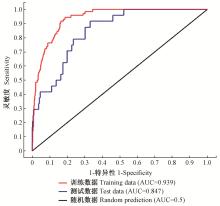
图1
MaxEnt模型中ROC预测结果"
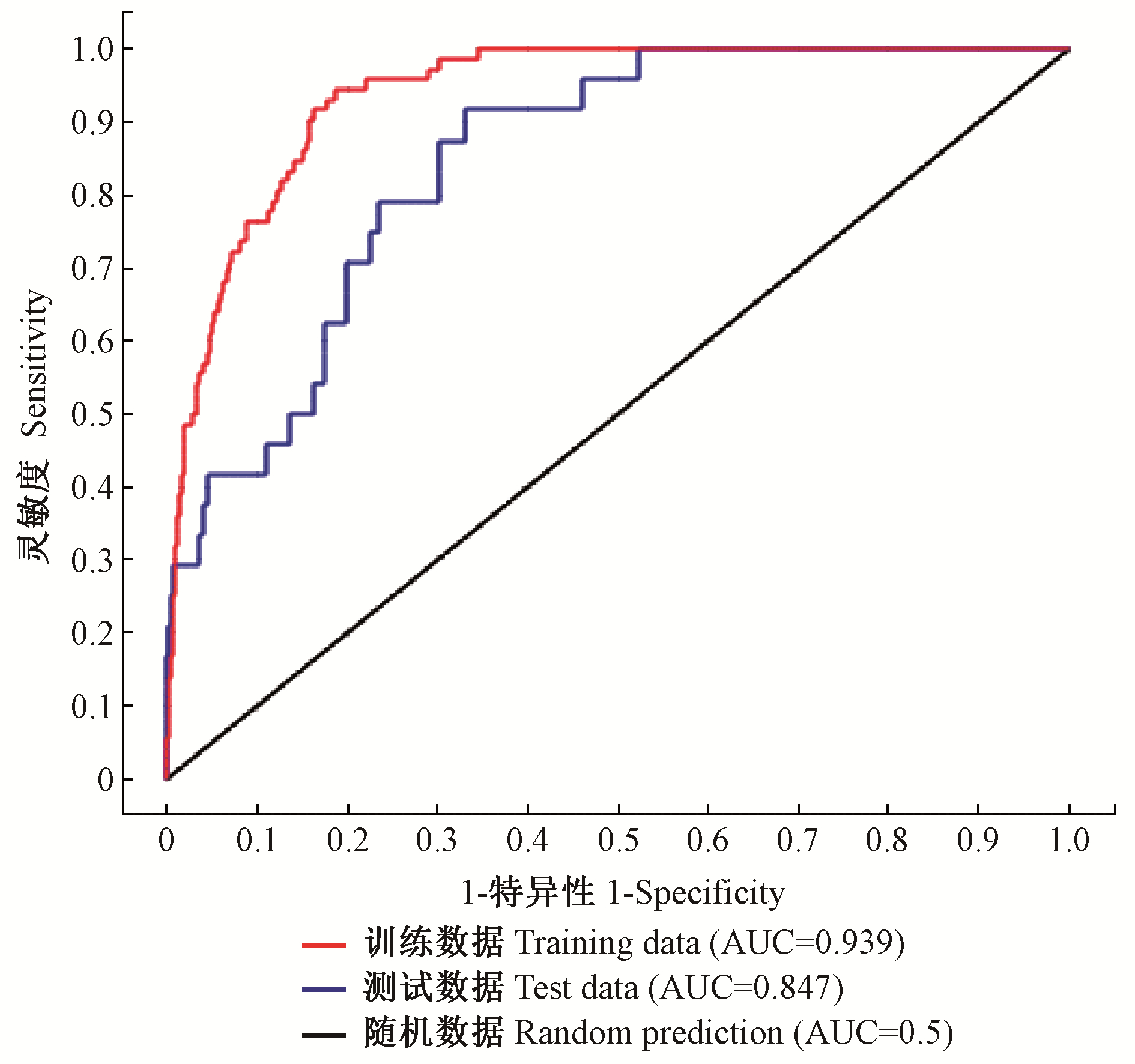
表3
不同气候变化情景下赤桉适生区面积"
| 气候变化情景 Climate change scenario | 最适生面积 Most suitable area | 适生面积 Suitable area | 不适生面积 Unsuitable area | 总适生面积(比例) Total suitable area (percentage) | |
| 当前 Current | 2010 | 137 768 | 266 551 | 2 491 384 | 404 319(14.0%) |
| RCP2.6 | 2041—2060 | 157 109 | 301 446 | 2 437 148 | 458 555(15.8%) |
| 2061—2080 | 162 397 | 300 619 | 2 432 687 | 463 016(16.0%) | |
| RCP4.5 | 2041—2060 | 140 557 | 277 716 | 2 477 430 | 418 273(14.4%) |
| 2061—2080 | 144 557 | 280 202 | 2 470 944 | 424 759(14.7%) | |
| RCP8.5 | 2041—2060 | 152 048 | 276 816 | 2 466 839 | 428 864(14.8%) |
| 2061—2080 | 141 828 | 288 571 | 2 465 304 | 430 399(14.9%) |
表4
当前气候情景下赤桉在研究区的潜在适生分布情况"
| 省(区) Province (region) | 地级市 Prefecture-level city | 县/县级市 County/county-level city | 最适生区 Most suitable region | 适生区 Suitable region |
| 广东 Guangdong | 梅州Meizhou | 平远Pingyuan | 西北部和南部Northwest and south | 东北部Northeast |
| 蕉岭Jiaoling | 中部和南部Central and south | 北部North | ||
| 梅县Meixian | 中北部和西部Central north and west | |||
| 丰顺Fengshun | 西南局部Parts of southwest | 北部North | ||
| 五华Wuhua | 东北局部Parts of northeast | 北部和中南部North and central south | ||
| 兴宁市Xingning | 中部和南部Central and south | 北部North | ||
| 大埔Dabu | 大部分Most | |||
| 韶关Shaoguan | 乐昌市Lechang | 东南部Southeast | ||
| 仁化Renhua | 中部和南部Central and south | 东北部Northeast | ||
| 始兴Shixing | 北部North | 中部和西南局部Central and parts of southwest | ||
| 南雄市Nanxiong | 东部East | |||
| 韶关市Shaoguan | 东北部和中南部Northeast and central south | |||
| 乳源Ruyuan | 东部局部Parts of east | |||
| 翁源Wengyuan | 东北部、西北部、南部Northeast, northwest and soutn | |||
| 新丰Xinfeng | 西部West | |||
| 湛江Zhanjiang | 廉江市Lianjiang | 东部和南部East and south | 北部North | |
| 雷州市Leizhou | 北部和中部局部North and parts of central | 西南局部Parts of southwest | ||
| 遂溪Suixi | 西部West | |||
| 吴川市Wuchuan | 东部局部Parts of east | |||
| 茂名市Maoming | 化州市Huazhou | 南部局部Parts of south | 东部和北部East and north | |
| 高州市Gaozhou | 西南局部Parts of southwest | 西北部Northwest | ||
| 茂名Maoming | 北部North | 南部South | ||
| 电白区Dianbai | 西部West | |||
| 肇庆Zhaoqing | 怀集Huaiji | 中部Central | 南部South | |
| 封开Fengkai | 西部West | 中部Central | ||
| 德庆Deqing | 西部局部Parts of west | |||
| 四会Sihui | 中部Central | |||
| 广宁Guangning | 中部Central | |||
| 高要Gaoyao | 中南部Central south | |||
| 清远Qingyuan | 清新区Qingxin | 西南部局部Parts of southwest | 中部局部Parts of central | |
| 连州市Lianzhou | 中部Central | 南部South | ||
| 英德市Yingde | 中部局部Parts of central | 南部South | ||
| 清远市Qingyuan | 大部分Most | |||
| 佛冈Fogang | 西部和北部West and north | |||
| 广西Guangxi | 梧州Wuzhou | 苍梧Cangwu | 北部North | 南部South |
| 藤县Tengxian | 中部局部Parts of central | |||
| 梧州市Wuzhou | 大部分Most | |||
| 贵港Guigang | 平南Pingnan | 中部Central | ||
| 桂平市Guiping | 东北部局部Parts of northeast | 中部Central | ||
| 贵港市Guigang | 中部Central | |||
| 贺州Hezhou | 贺州市Hezhou | 南部局部Parts of south | 北部局部Parts of north | |
| 钟山Zhongshan | 东部East | |||
| 百色Baise | 百色市Baise | 中部Central | ||
| 田阳Tianyang | 中部局部Parts of central | |||
| 江西Jiangxi | 赣州Ganzhou | 信丰Xinfeng | 大部分Most | |
| 安远Anyuan | 北部局部Parts of north | 南部局部Parts of south | ||
| 会昌Huichang | 大部分Most | |||
| 瑞金市Ruijin | 中部和南部Central and south | 北部局部Parts of north | ||
| 于都Yudu | 中部和北部Central and north | |||
| 赣县区Ganxian | 北部和南部局部North and parts of south | |||
| 赣州市Ganzhou | 大部分Most | |||
| 南康区Nankang | 中部和南部Central and south | |||
| 大余Dayu | 南部局部Parts of south | |||
| 石城Shicheng | 大部分Most | |||
| 宁都Ningdu | 中部局部和南部Parts of central and south | |||
| 兴国Xingguo | 南部局部Parts of south | |||
| 吉安Ji’an | 万安Wan’an | 北部North | 南部局部Parts of south | |
| 遂川Suichuan | 东部局部Parts of east | |||
| 泰和Taihe | 中部Central | |||
| 吉安Ji’an | 东部East | |||
| 宜春Yichun | 樟树市Zhangshu | 大部分Most | ||
| 抚州Fuzhou | 广昌Guangchang | 南部局部Parts of south | 大部分Most | |
| 南丰Nanfeng | 南部局部Parts of south | 东部East | ||
| 黎川Lichuan | 中部Central | |||
| 福建Fujian | 漳州Zhangzhou | 诏安Zhao’an | 南部South | 北部局部Parts of north |
| 漳浦Zhangpu | 中部Central | 北部North | ||
| 龙海市Longhai | 北部局部Parts of north | 中部和南部Central and south | ||
| 长泰Changtai | 中部Central | 东部局部Parts of east | ||
| 南靖Nanjing | 东南局部Parts of southeast | 中部Central | ||
| 漳州市Zhangzhou | 大部分Most | |||
| 云霄Yunxiao | 中部局部Parts of central | |||
| 华安Hua’an | 中部Central | |||
| 平和Pinghe | 东部East | |||
| 龙岩Longyan | 上杭Shanghang | 西部West | 中部局部Parts of central | |
| 武平Wuping | 南部South | 北部局部Parts of north | ||
| 长汀Changting | 南部South | 中部局部Parts of central | ||
| 龙岩市Longyan | 东部局部Parts of east | 中部局部Parts of central | ||
| 连城Liancheng | 西部West | |||
| 漳平市Zhangping | 中部局部Parts of central | |||
| 永定区Yongding | 西部局部和北部Parts of west and north | |||
| 三明Sanming | 宁化Ninghua | 中部局部Parts of central | 东部East | |
| 清流Qingliu | 中部局部Parts of central | 西部和东部West and east | ||
| 尤溪Youxi | 中部Central | 西部局部和南部局部Parts of west and parts of south | ||
| 沙县Shaxian | 中部和北部Central and north | 南部局部Parts of south | ||
| 永安市Yong’an | 中部Central | |||
| 将乐Jiangle | 中部局部Parts of central | |||
| 泰宁Taining | 中部Central | |||
| 三明市Sanming | 西部West | |||
| 明溪Mingxi | 大部分Most | |||
| 大田Datian | 北部North | |||
| 泉州Quanzhou | 晋江市Jinjiang | 中部和南部Central and south | 北部局部Parts of north | |
| 南安市Nan’an | 中部局部Parts of central | 大部分Most | ||
| 安溪Anxi | 东部East | |||
| 永春Yongchun | 东部East | |||
| 惠安Hui’an | 中部和东部Central and east | 西部和北部West and north | ||
| 福州Fuzhou | 永泰Yongtai | 中部局部Parts of central | 东部和西部局部East and parts of west | |
| 闽侯Minhou | 中部局部和南部局部Parts of central and south | |||
| 福清市Fuqing | 中部局部Parts of central | |||
| 闽清Minqing | 中部和南部Central and south | |||
| 连江Lianjiang | 中部局部Parts of central | |||
| 云南Yunnan | 楚雄Chuxiong | 元谋Yuanmou | 大部分Most | |
| 永仁Yongren | 南部South | |||
| 牟定Mouding | 南部South | |||
| 禄丰Lufeng | 西南部Southwest | |||
| 丽江Lijiang | 华坪Huaping | 中部局部Parts of central | ||
| 普洱Pu’er | 景东Jingdong | 中部局部Parts of central | ||
| 玉溪Yuxi | 新平Xinping | 北部局部Parts of north | ||
| 元江Yuanjiang | 中部局部Parts of central | |||
| 玉溪市Yuxi | 中部局部Parts of central | |||
| 红河州Honghe | 建水Jianshui | 中部局部Parts of central | ||
| 开远市Kaiyuan | 西部局部Parts of west | |||
| 弥勒市Mile | 南部和中部局部South and parts of central | |||
| 蒙自市Mengzi | 西北部局部Parts of northwest | |||
| 西双版纳 Xishuangbanna | 勐海Menghai | 中部局部Parts of central | ||
| 湖南Hunan | 永州Yongzhou | 道县Daoxian | 中部Central | |
| 宁远Ningyuan | 中部Central | |||
| 蓝山Lanshan | 北部North | |||
| 江华Jianghua | 西部局部Parts of west | |||
| 江永Jiangyong | 东部局部Parts of east | |||
| 郴州Chenzhou | 宜章Yizhang | 中部Central | ||
| 临武Linwu | 东南部Southeast | |||
| 嘉禾Jiahe | 大部分Most | |||
| 桂阳Guiyang | 南部South | |||
| 郴州市Chenzhou | 北部North | |||
| 海南Hainan | 儋州市Danzhou | 临高Lin’gao | 北部North | 南部South |
| 北部局部Parts of north | 中部Central | |||
| 澄迈Chengmai | 中部局部Parts of central | 南部South | ||
| 文昌市Wenchang | 大部分Most |
表5
赤桉在原产地自然分布区和中国适生区之间的生态因子相似性①"
| 环境变量 Environmental variable | 中国不适生区 Unsuitable areain China | 中国适生区 Suitable area in China | 中国最适生区 Most suitable area in China | 澳大利亚自然分布区 Natural distribution in Australia |
| 最干季度平均气温Mean temperature of the driest quarter/℃ | 7.0a | 13.5b | 13.8b | 18.6b |
| 气温季节变化方差Seasonal temperature variance/℃ | 62.8a | 59.30a | 60.40a | 49.6a |
| 最热月份最高气温Maximumtemperature of the warmest month/℃ | 27.4a | 31.9ab | 32.6ab | 35.1b |
| 最热季度平均气温Mean temperature of the warmest quarter/℃ | 22.2a | 26.9a | 27.5a | 27.3a |
| 海拔Altitude/m | 1 322.3a | 394.8b | 320.2b | 274.6b |
| 最热季度降水量Precipitation of the warmest quarter/mm | 578.8a | 598.6a | 542.8a | 167.7b |
| 年降水量Annual precipitation/mm | 1 278.3a | 1 480.0a | 1 432.4a | 461.6b |
| 坡度Slope/(°) | 5.3a | 2.49b | 1.72c | 1.1 d |
| 坡向Aspect/(°) | 181.0a | 174.1a | 170.4a | 179.5a |
| 太阳辐射Solar radiation/(MJ· m-2a-1) | 13.8a | 14.7a | 14.7a | 20.5b |
|
韩斐扬, 周群英, 陈少雄. 雷州半岛桉树能源林品种选择与评价. 西北林学院学报, 2013. 28 (1): 77- 81.
doi: 10.3969/j.issn.1001-7461.2013.01.14 |
|
|
Han F Y , Zhou Q Y , Chen S X . Species selection and evaluation of Eucalyptus energy forest in Leizhou peninsula. Journal of Northwest Forestry University, 2013. 28 (1): 77- 81.
doi: 10.3969/j.issn.1001-7461.2013.01.14 |
|
|
胡秀, 吴福川, 郭微, 等. 基于MaxEnt生态学模型的檀香在中国的潜在种植区预测. 林业科学, 2014. 50 (5): 27- 33.
doi: 10.11707/j.1001-7488.20140504 |
|
|
Hu X , Wu F C , Guo W , et al. Identification of potential cultivation region for Santalum album in China by the MaxEnt ecologic niche model. Scientia Silvae Sinicae, 2014. 50 (5): 27- 33.
doi: 10.11707/j.1001-7488.20140504 |
|
|
金同伟. 红河州桉树引种栽培现状及发展建议. 林业调查规划, 2013. 38 (2): 116- 120.
doi: 10.3969/j.issn.1671-3168.2013.02.027 |
|
|
Jin T W . Introduction and cultivation status and development suggestions of Eucalyptus in Honghe prefecture. Forest Inventory and Planning, 2013. 38 (2): 116- 120.
doi: 10.3969/j.issn.1671-3168.2013.02.027 |
|
|
李德, 李福秀. 赤桉苗木抗旱性研究. 林业调查规划, 2014. 39 (4): 151- 157.
doi: 10.3969/j.issn.1671-3168.2014.04.035 |
|
|
Li D , Li F X . Drought resistance of Eucalyptus camaldulensis seedling. Forest Inventory and Planning, 2014. 39 (4): 151- 157.
doi: 10.3969/j.issn.1671-3168.2014.04.035 |
|
| 卢万鸿, 杨桂丽, 林彦, 等. 桉树叶片水分状态的近红外光谱检测. 林业科学, 2017. 53 (5): 16- 22. | |
| Lu W H , Yang G L , Lin Y , et al. Assessing leaf water status of Eucalyptus using NIRS. Scientia Silvae Sinicae, 2017. 53 (5): 16- 22. | |
|
罗火月. 闽南山地桉树优良无性系选择试验研究. 安徽农学通报, 2012. 18 (1): 128- 130.
doi: 10.3969/j.issn.1007-7731.2012.01.057 |
|
|
Luo H Y . Growing study on the clones of Eucalyptus species in southern Fujian. Anhui Agricultural Science Bulletin, 2012. 18 (1): 128- 130.
doi: 10.3969/j.issn.1007-7731.2012.01.057 |
|
| 王豁然. 桉树生物学概论. 北京: 科学出版社. 2010. 30-45 | |
| Wang H R . A Chinese appreciation of eucalypts. Beijing: Science Press. 2010. | |
| 王雷宏, 杨俊仙, 徐小牛. 基于MaxEnt分析金钱松适生的生物气候特征. 林业科学, 2015. 51 (1): 127- 131. | |
| Wang L H , Yang J X , Xu X N . Analysis of suitable bioclimatic characteristics of Pseudolarix amabilis by using MaxEnt model. Scientia Silvae Sinicae, 2015. 51 (1): 127- 131. | |
| 魏润鹏. 桉树无性系顶梢伸长节律及其在良种选择中的潜在作用. 林业科学, 2012. 48 (7): 153- 160. | |
| Wei R P . Leading shoot elongation rhythm and its potential role in selection of Eucalypt clones. Scientia Silvae Sinicae, 2012. 48 (7): 153- 160. | |
|
严思维, 陈爱民, 林勇明, 等. 干热河谷区不同林龄赤桉叶中养分含量和再吸收率的比较及其线性回归分析. 植物资源与环境学报, 2017. 26 (1): 39- 46.
doi: 10.3969/j.issn.1674-7895.2017.01.05 |
|
|
Yan S W , Chen A M , Lin Y M , et al. Comparisons on content and reabsorption rate of nutrients in leaf of Eucalyptus camaldulensis at different stand ages in arid-hot valley and their linear-regression analysis. Journal of Plant Resources and Environment, 2017. 26 (1): 39- 46.
doi: 10.3969/j.issn.1674-7895.2017.01.05 |
|
|
Adams-Hosking C , McAlpine C , Rhodes J R , et al. Modelling changes in the distribution of the critical food resources of a specialist folivore in response to climate change. Diversity and Distributions, 2012. 18 (9): 847- 860.
doi: 10.1111/j.1472-4642.2012.00881.x |
|
| Booth T H , Jovanovic T , New M . A new world climatic mapping program to assist species selection. Forest Ecology and Management, 2002. 163 (1): 111- 117. | |
|
Booth T H . Mapping regions climatically suitable for particular tree species at the global scale. Forest Ecology and Management, 1990. 36 (1): 47- 60.
doi: 10.1016/0378-1127(90)90063-H |
|
| Bush D , Marcar N , Arnold R , et al. Assessing genetic variation within Eucalyptus camaldulensis for survivaland growth on two spatially variable saline sites in southern Australia. Forest Ecology and Management, 2013. 306 (6): 68- 78. | |
|
Cao B , Bai C K , Zhang L L , et al. Modeling habitat distribution of Cornus officinalis with Maxent modeling and fuzzy logics in China. Journal of Plant Ecology, 2016. 9 (6): 742- 751.
doi: 10.1093/jpe/rtw009 |
|
|
Cha-um S , Kirdmanee C . Effects of water stress induced by sodium chloride and mannitol on proline accumulation, photosynthetic abilities and growth characters of eucalyptus (Eucalyptus camaldulensis Dehnh.).. New Forests, 2010. 40 (3): 349- 360.
doi: 10.1007/s11056-010-9204-1 |
|
|
Cupertino-Eisenlohr M A , Vinicius-Silva R , Meireles L D , et al. Stability or breakdown under climate change? A key group of woody bamboos will find suitable areas in its richness center. Biodiversity and Conservation, 2017. 26 (8): 1845- 1861.
doi: 10.1007/s10531-017-1332-x |
|
|
Dzikiti S , Gush M B , Maitre D C L , et al. Quantifying potential water savings from clearing invasive alien Eucalyptus camaldulensis using in situ and high resolution remote sensing data in the Berg River Catchment, Western Cape, South Africa. Forest Ecology and Management, 2016. 361, 69- 80.
doi: 10.1016/j.foreco.2015.11.009 |
|
|
Elith J , Phillips S J , Hastie T , et al. A statistical explanation of MaxEnt for ecologists. Diversity and Distributions, 2011. 17 (1): 43- 57.
doi: 10.1111/j.1472-4642.2010.00725.x |
|
|
Ellis M V , Taylor J E , Rayner L . Growth characteristics of Eucalyptus camaldulensis trees differ between adjacent regulated and unregulated rivers in semi-arid temperate woodlands. Forest Ecology and Management, 2017. 398, 1- 9.
doi: 10.1016/j.foreco.2017.05.004 |
|
|
Gezahgne A , Roux J , Wingfield M J . First report of pink disease on Eucalyptus camaldulensis in Ethiopia. Plant Pathology, 2003. 52 (3): 402.
doi: 10.1046/j.1365-3059.2003.00824.x |
|
|
Jaynes E T . Information theory and statistical mechanics. Physical Review, 1957. 106 (4): 620- 630.
doi: 10.1103/PhysRev.106.620 |
|
|
Kelly R , Leach K , Cameron A , et al. Combining global climate and regional landscape models to improve prediction of invasion risk. Diversity and Distributions, 2014. 20 (8): 884- 894.
doi: 10.1111/ddi.12194 |
|
|
Kogawara S , Yamanoshita T , Norisada M , et al. Photosynthesis and photoassimilate transport during root hypoxia in Melaleuca cajuputi, a flood-tolerant species, and in Eucalyptus camaldulensis, a moderately flood-tolerant species. Tree Physiology, 2006. 26 (11): 1413- 1423.
doi: 10.1093/treephys/26.11.1413 |
|
|
Li G Q , Xu G H , Guo K , et al. Geographical boundary andclimatic analysis of Pinus tabulaeformis in China:insights on its afforestation. Ecological Engineering, 2016. 86, 75- 84.
doi: 10.1016/j.ecoleng.2015.10.032 |
|
| Mays M , Suliman A M , Ahmad H . Flowering phenology of river red gum (Eucalyptus camaldulensis Dehnh.) associations in Homs province. Syria.. Arab Gulf Journal of Scientific Research, 2014. 32 (2/3): 102- 110. | |
|
McDonald M W , Brooker M I H , Butcher P A , et al. A taxonomic revision of Eucalyptus camaldulensis (Myrtaceae). Australian Systematic Botany, 2009. 22 (4): 257- 285.
doi: 10.1071/SB09005 |
|
|
Meier E S , Lischke H , Schmatz D R , et al. Climate, competition and connectivity affect future migration and ranges of European trees. Global Ecology and Biogeography, 2012. 21 (2): 164- 178.
doi: 10.1111/j.1466-8238.2011.00669.x |
|
|
Phillips S J , Dudík M . Modeling of species distributions with Maxent:new extensions and a comprehensive evaluation. Ecography, 2008. 31 (2): 161- 175.
doi: 10.1111/j.0906-7590.2008.5203.x |
|
|
Poss J A , Grattan S R , Suarez D L , et al. Stable carbon isotope discrimination:an indicator of cumulative salinity and boron stress in Eucalyptus camaldulensis.. Tree Physiology, 2000. 20 (16): 1121- 1127.
doi: 10.1093/treephys/20.16.1121 |
|
|
Rad M H , Assare M H , Banakar M H , et al. Effects of different soil moisture regimes on leaf area index, specific leaf area and water use efficiency in Eucalyptus (Eucalyptus camaldulensis Dehnh) under dry climatic conditions. Asian Journal of Plant Sciences, 2011. 10 (5): 294- 300.
doi: 10.3923/ajps.2011.294.300 |
|
|
Ramírez-Amezcua Y , Steinmann V W , Ruiz-Sanchez E , et al. Mexican alpine plants in the face of global warming:potential extinction within a specialized assemblage of narrow endemics. Biodiversity and Conservation, 2016. 25 (5): 865- 885.
doi: 10.1007/s10531-016-1094-x |
|
|
Varghese M , Harwood C E , Bush D J , et al. Growth and wood properties of natural provenances, local seed sources and clones of Eucalyptus camaldulensis in southern India:implications for breeding and deployment. New Forests, 2017. 48 (1): 67- 82.
doi: 10.1007/s11056-016-9556-2 |
|
|
Wang C J , Wan J Z , Mu X Y , et al. Management planning for endangered plant species in priority protected areas. Biodiversity and Conservation, 2015. 24 (10): 2383- 2397.
doi: 10.1007/s10531-015-0928-2 |
|
|
Watanabe Y , Masunaga T , Fashola O O . Eucalyptus camaldulensis and Pinus caribaea growth in relation to soil physico-chemical properties in plantation forests in Northern Nigeria(soil fertility). Soil Science and Plant Nutrition, 2009. 55 (1): 132- 141.
doi: 10.1111/j.1747-0765.2008.00340.x |
|
|
Yi Y J , Cheng X , Yang Z F , et al. Maxent modeling for predicting the potential distribution of endangered medicinal plant (H. riparia Lour) in Yunnan, China. Ecological Engineering, 2016. 92, 260- 269.
doi: 10.1016/j.ecoleng.2016.04.010 |
|
|
Yu F Y , Groen T A , Wang T J , et al. Climatic niche breadth can explain variation in geographical range size of alpine and subalpine plants. International Journal of Geographical Information Science, 2017. 31 (1): 190- 212.
doi: 10.1080/13658816.2016.1195502 |
|
|
Zohar Y , Gafni A , Morris J , et al. Eucalyptus plantations in Israel:an assessment of economic and environmental viability. New Forests, 2008. 36 (2): 135- 157.
doi: 10.1007/s11056-008-9089-4 |
| [1] | 李亚藏, 冯仲科. 气候敏感的马尾松生物量相容性方程系统研建[J]. 林业科学, 2019, 55(5): 65-73. |
| [2] | 王晓玮, 任雪燕, 梁英梅. 基于MaxEnt模型的松针红斑病在中国的潜在分布区及适生性预测分析[J]. 林业科学, 2019, 55(4): 160-170. |
| [3] | 吕振刚, 李文博, 黄选瑞, 张志东. 气候变化情景下河北省3个优势树种适宜分布区预测[J]. 林业科学, 2019, 55(3): 13-21. |
| [4] | 厉静文, 郭浩, 王雨生, 辛智鸣, 吕永军. 基于MaxEnt模型的胡杨潜在适生区预测[J]. 林业科学, 2019, 55(12): 133-139. |
| [5] | 吕振刚,李文博,黄选瑞,张志东. 气候变化情景下基于潜在NPP的河北省华北落叶松生长适宜性[J]. 林业科学, 2019, 55(11): 37-44. |
| [6] | 刘丹, 李玉堂, 洪玲霞, 国红, 谢阳生, 张卓立, 雷相东, 唐守正. 基于最大熵模型的吉林省主要天然林潜在分布适宜性[J]. 林业科学, 2018, 54(7): 1-15. |
| [7] | 王婧如, 王明浩, 张晓玮, 孙杉, 赵长明. 同倍体杂交物种紫果云杉的生态位分化及其未来潜在分布区预测[J]. 林业科学, 2018, 54(6): 63-72. |
| [8] | 路伟伟, 余新晓, 贾国栋, 李瀚之, 刘自强. 密云山区油松树轮δ13C对气温和降水量变化的响应[J]. 林业科学, 2018, 54(3): 1-7. |
| [9] | 苑冉, 李欣悦, 吴韶平, 曹传旺. CO2浓度升高对舞毒蛾生长发育和体内解毒酶及保护酶活性的影响[J]. 林业科学, 2018, 54(12): 102-109. |
| [10] | 王家鸣, 许涵, 李意德, 林明献, 周璋, 骆土寿, 陈德祥. 地形异质性对尖峰岭热带山地雨林木本植物群落结构及多样性的影响[J]. 林业科学, 2018, 54(1): 1-11. |
| [11] | 钱杨, 孙洪刚, 董汝湘, 姜景民. 针叶树碳水化合物分配研究进展[J]. 林业科学, 2018, 54(1): 141-153. |
| [12] | 田晓瑞, 舒立福, 赵凤君, 王明玉. 气候变化对中国森林火险的影响[J]. 林业科学, 2017, 53(7): 159-169. |
| [13] | 宋雄刚, 王鸿斌, 张真, 孔祥波, 苗振旺, 刘随存, 李永福. 应用最大熵模型模拟预测大尺度范围油松毛虫灾害[J]. 林业科学, 2016, 52(6): 66-75. |
| [14] | 苗庆林, 田晓瑞. 多气候情景下大兴安岭森林燃烧性评估[J]. 林业科学, 2016, 52(10): 109-116. |
| [15] | 程瑞梅, 刘泽彬, 封晓辉, 肖文发. 气候变化对树木木质部生长影响的研究进展[J]. 林业科学, 2015, 51(6): 147-154. |
| 阅读次数 | ||||||
|
全文 |
|
|||||
|
摘要 |
|
|||||