
Scientia Silvae Sinicae ›› 2021, Vol. 57 ›› Issue (9): 66-75.doi: 10.11707/j.1001-7488.20210907
Previous Articles Next Articles
Junpeng Zhao,Lei Zhao,Erxue Chen*,Xiangxing Wan,Kunpeng Xu
Received:2020-06-10
Online:2021-09-25
Published:2021-11-29
Contact:
Erxue Chen
CLC Number:
Junpeng Zhao,Lei Zhao,Erxue Chen,Xiangxing Wan,Kunpeng Xu. Synergy Application of ZY3 Stereo Imaging Pairs and airborne LiDAR Sampling Data for Estimating Mean Height of Forest[J]. Scientia Silvae Sinicae, 2021, 57(9): 66-75.
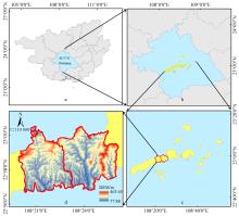
Fig.1
Location and coverage map of study area"

Table 1
Parameter configuration of the LiDAR sensor"
| 参数Parameter | 值Value | 参数Parameter | 值Value | |
| 波长Wavelength/nm | 1 550 | 飞行高度Flying height/m | 1 000 | |
| 扫描角Scan angle/(°) | ±30 | 脉冲长度Pulse length/ns | 3 | |
| 垂直精度Vertical accuracy/cm | 15 | 脉冲频率Pulse frequency/kHz | 400 | |
| 平均点密度Mean point density/m-2 | 8.51 | 光束发散度Beam divergence/(m·rad) | 0.5 |

Fig.2
Technical route for practical application scenario"

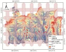
Fig.3
Distribution of the experimental data"

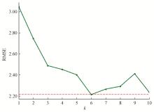
Fig.4
The RMSE of models with different k values"
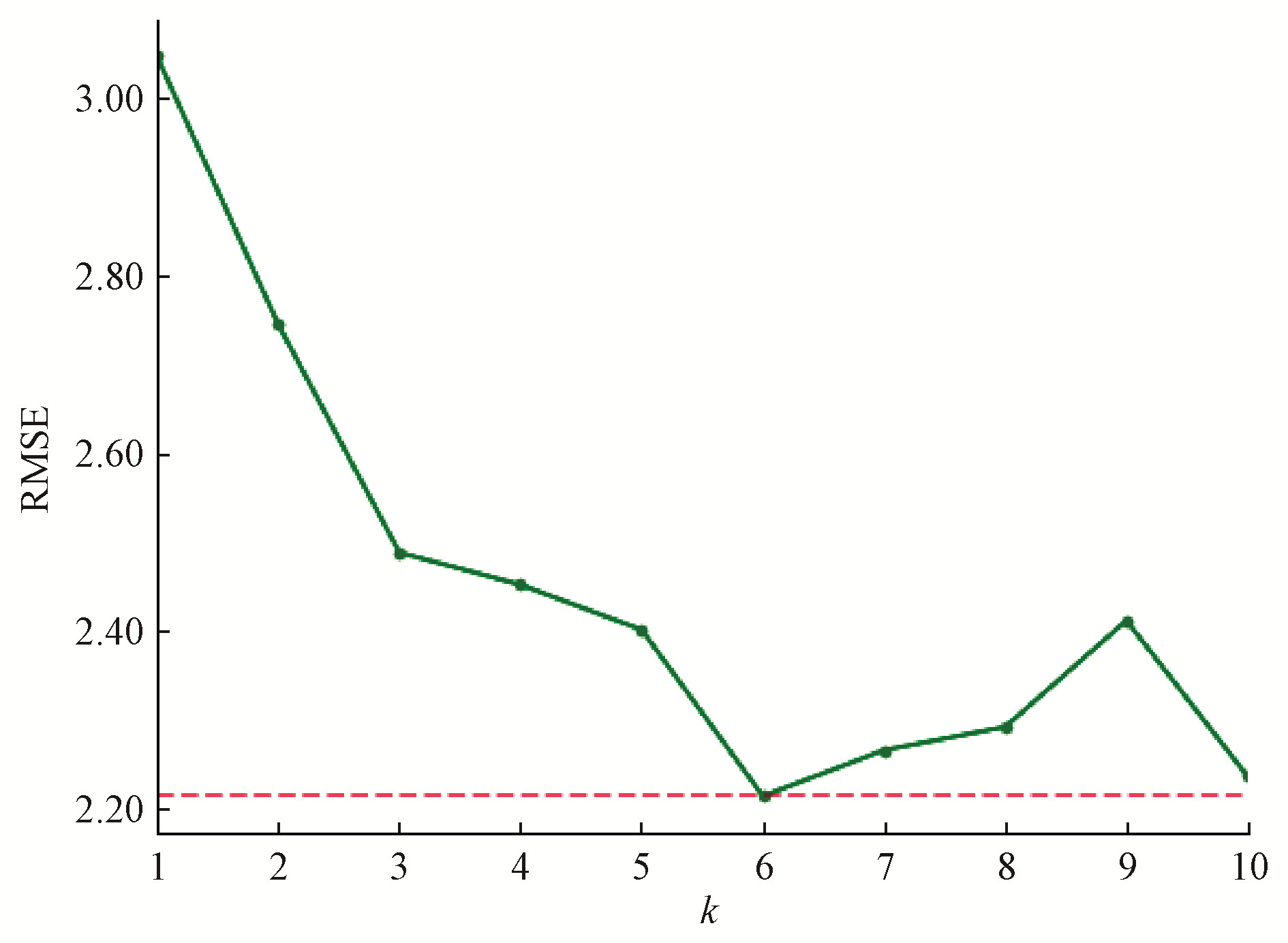
Table 2
Parameters of different variogram models for residuals"
| 残差来源Source of residulas | 拟合模型Models | 块金值Nugget | 基台值Sill | 变程Range/m |
| OLS | 指数Exponential | 0.03 | 0.92 | 95.49 |
| Stable | 0 | 0.92 | 105.01 | |
| KNN | 指数Exponential | 0.39 | 0.94 | 164.98 |
| Stable | 0 | 0.95 | 148.25 |
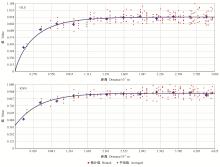
Fig.5
Variograms and fitted models of residuals from OLS and KNN"
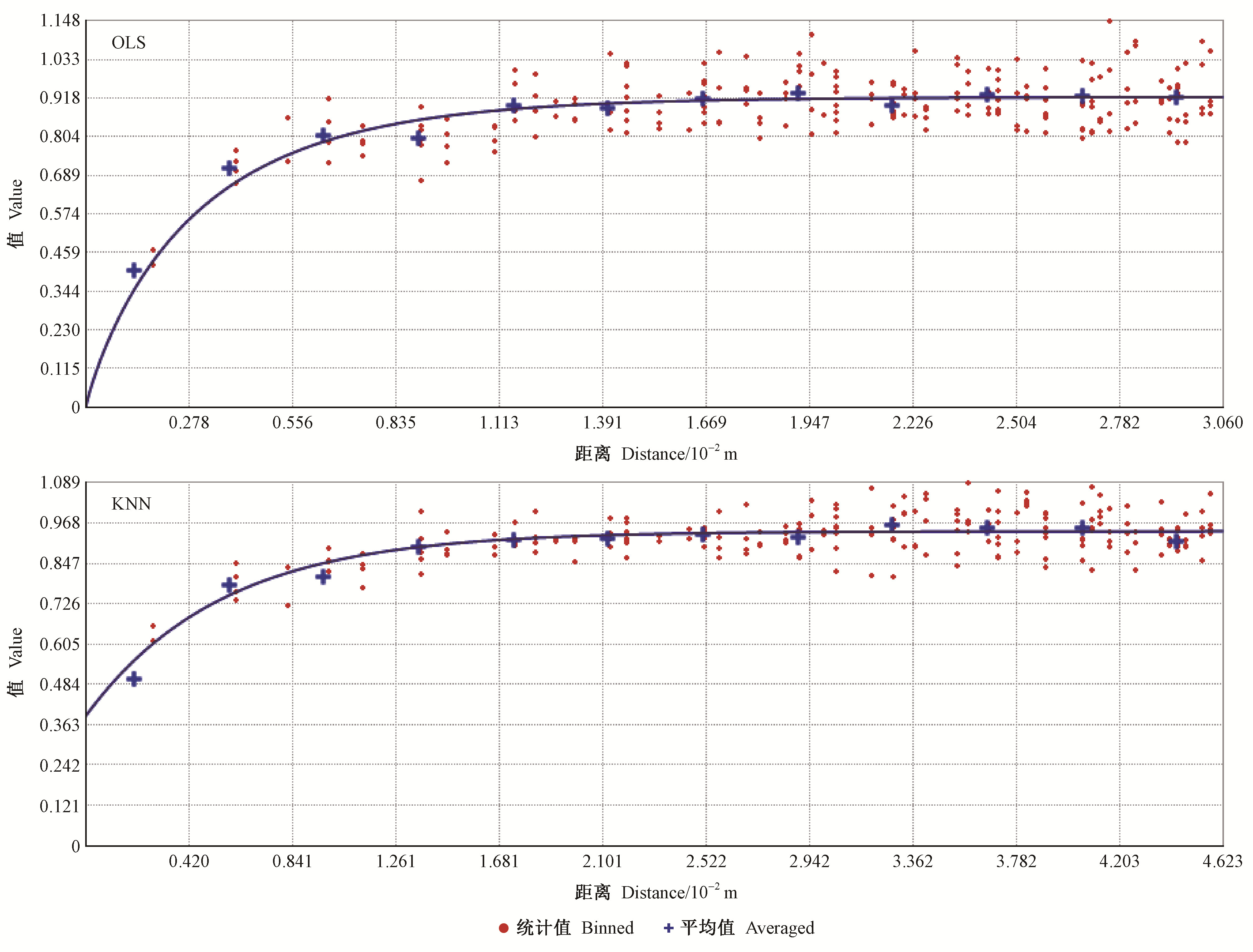
Fig.6
Scatter plots of predicted versus validation data"

Table 3
The accuracy comparison of four kinds of models"
| 模型Models | 相关系数r | 平均误差ME/m | 均方根误差RMSE/m | 估测精度EA(%) |
| OLS | 0.40 | -0.21 | 1.88 | 87.18 |
| KNN | 0.50 | -1.15 | 1.96 | 86.64 |
| RKOLS | 0.46 | -0.16 | 1.84 | 87.42 |
| RKKNN | 0.57 | -1.07 | 1.86 | 87.32 |
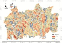
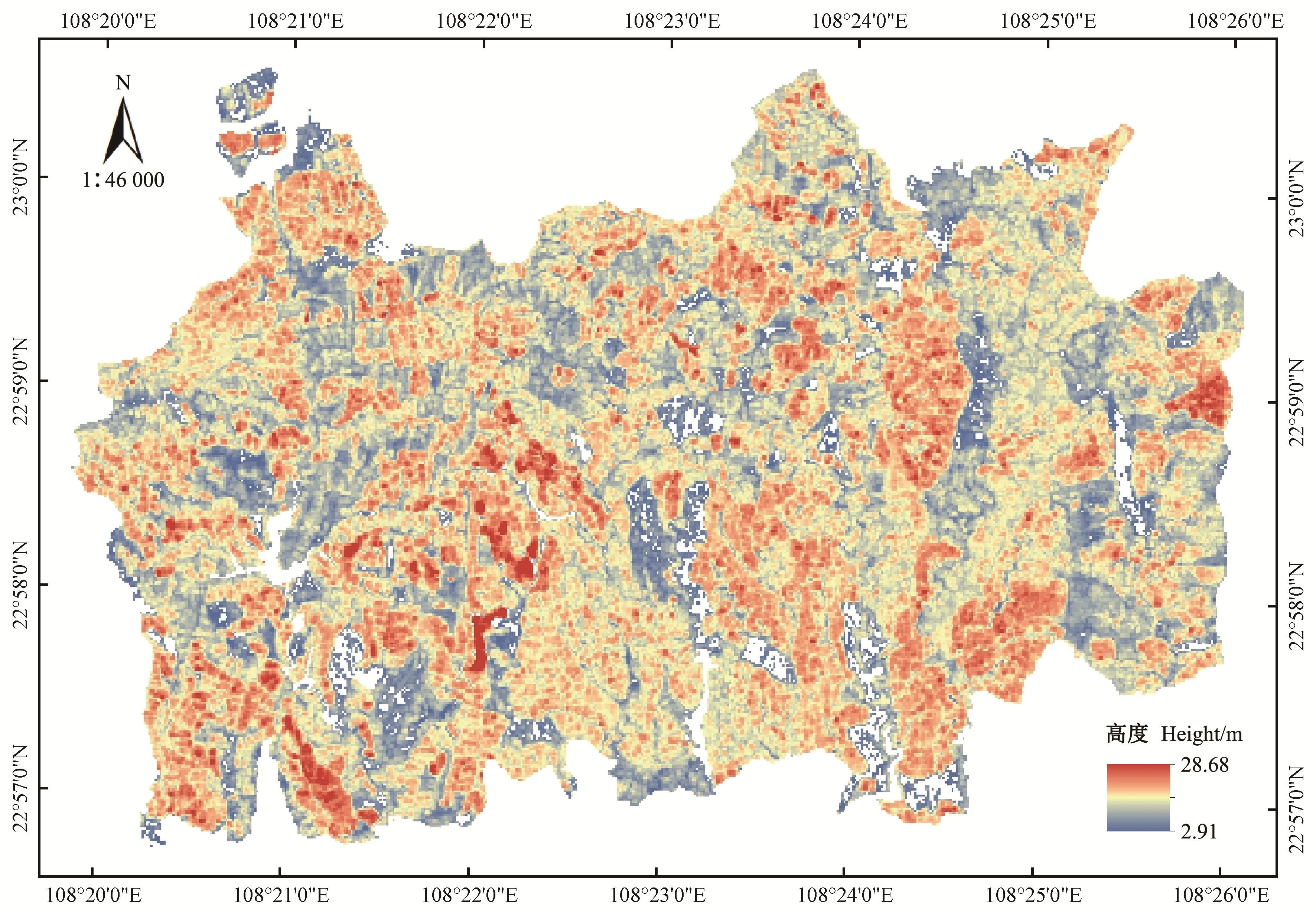
Fig.7
Spatial distribution of the estimated MHF"
| 曹林, 佘光辉. 基于机载小光斑全波形LiDAR的亚热带林分特征反演. 林业科学, 2015, 51 (6): 81- 92. | |
| Cao L , She G H . Inversion of forest stand characteristics using small-footprint full-waveform airborne LiDAR in a subtropical forest. Scientia Silvae Sinicae, 2015, 51 (6): 81- 92. | |
| 冯益明, 李增元, 张旭. 基于高空间分辩率影像的林分冠幅估计. 林业科学, 2006, 42 (5): 110- 113. | |
| Feng Y M , Li Z Y , Zhang X . Estimating forest stand crown based on high spatial resolution image. Scientia Silvae Sinicae, 2006, 42 (5): 110- 113. | |
| 冯益明, 唐守正, 李增元. 空间统计分析在林业中的应用. 林业科学, 2004, 40 (3): 149- 155. | |
| Feng Y M , Tang S Z , Li Z Y . Application of spatial statistic analysis in forestry. Scientia Silvae Sinicae, 2004, 40 (3): 149- 155. | |
| 郭含茹, 张茂震, 徐丽华, 等. 基于地理加权回归的区域森林碳储量估计. 浙江农林大学学报, 2015, 32 (4): 497- 508. | |
| Guo H R , Zhang M Z , Xu L H , et al. Geographically weighted regression based on estimation of regional forest carbon storage. Journal of Zhejiang A & F University, 2015, 32 (4): 497- 508. | |
| 闾妍宇, 李超, 欧光龙, 等. 基于地理加权回归模型的思茅松生物量遥感估测. 林业资源管理, 2017, (1): 82- 90. | |
| Lü Y Y , Li C , Ou G L , et al. Remote sensing estimation of biomass of Pinus kesiya var. langbianensis by geographically weighted regression models. Forest Resources Mangement, 2017, (1): 82- 90. | |
| 倪文俭, 张大凤, 汪垚, 等. 高分二号异轨立体数据的森林高度提取. 遥感学报, 2018, 22 (3): 392- 399. | |
| Ni W J , Zhang D F , Wang Y , et al. Extraction of forest height by using GF-2 cross-track stereo images. Journal of Remote Sensing, 2018, 22 (3): 392- 399. | |
| 庞勇, 李增元, 陈尔学, 等. 激光雷达技术及其在林业上的应用. 林业科学, 2005, 41 (1): 129- 136. | |
| Pang Y , Li Z Y , Chen E X , et al. LiDAR remote sensing technology and its application in forestry. Scientia Silvae Sinicae, 2005, 41 (1): 129- 136. | |
| 庞勇, 赵峰, 李增元, 等. 机载激光雷达平均树高提取研究. 遥感学报, 2008, 12 (1): 152- 158. | |
| Pang Y. , Zhao F , Li Z Y , et al. Forest Height Inversion using Airborne Lidar Technology. Journal of Remote Sensing, 2008, 12 (1): 152- 158. | |
|
王效科, 冯宗炜, 欧阳志云. 中国森林生态系统的植物碳储量和碳密度研究. 应用生态学报, 2001, 12 (1): 13- 16.
doi: 10.3321/j.issn:1001-9332.2001.01.003 |
|
|
Wang X K , Feng Z W , Ouyang Z Y . Vegetation carbon storage and density of forest ecosystems in China. Chinese Journal of Applied Ecology, 2001, 12 (1): 13- 16.
doi: 10.3321/j.issn:1001-9332.2001.01.003 |
|
|
王紫君, 申广荣, 朱赟, 等. 基于遥感和空间分析的上海城市森林生物量分布特征. 植物生态学报, 2016, 40 (4): 385- 394.
doi: 10.17521/cjpe.2015.1102 |
|
|
Wang Z J , Shen G R , Zhu Y , et al. Research on characteristics of biomass distribution in urban forests of Shanghai metropolis based on remote sensing and spatial analysis. Chinese Journal of Plant Ecology, 2016, 40 (4): 385- 394.
doi: 10.17521/cjpe.2015.1102 |
|
| 向安民, 刘凤伶, 于宝义, 等. 基于k-NN方法和GF遥感影像的森林蓄积量估测. 浙江农林大学学报, 2017, 34 (3): 406- 412. | |
| Xiang A M , Liu F L , Yu B Y , et al. Forest stock volume estimation based on the k-NN method and GF remote sensing data. Journal of Zhejiang A & F University, 2017, 34 (3): 406- 412. | |
| 邢艳秋, 张锦绣, 陈世培, 等. 联合资源三号与机载LiDAR的林分平均树高估测. 中南林业科技大学学报, 2018, 38 (11): 10- 16. | |
| Xing Y Q , Zhang J X , Chen S P , et al. Mean canopy height estimation by combing ZY-3 data and airborne LiDAR. Journal of Central South University of Forestry & Technology, 2018, 38 (11): 10- 16. | |
| 郑刚, 彭世揆, 戎慧, 等. 基于KNN方法的森林蓄积量遥感估计和反演概述. 遥感技术与应, 2010, (3): 430- 437. | |
| Zheng G , Peng S K , Rong H , et al. A general introduction to estimation and retrieval of forest volume with remote sensing based on KNN. Remote Sensing Technology and Application, 2010, (3): 430- 437. | |
|
Chen G , Hay G J . An airborne LiDAR sampling strategy to model forest canopy height from QuickBird imagery and GEOBIA. Remote Sensing of Environment, 2011, 115 (6): 1532- 1542.
doi: 10.1016/j.rse.2011.02.012 |
|
|
Chopping M , Nolin A , Moisen G G , et al. Forest canopy height from the multiangle imaging spectroradiometer(MISR) assessed with high resolution discrete return LiDAR. Remote Sensing of Environment, 2009, 113 (10): 2172- 2185.
doi: 10.1016/j.rse.2009.05.017 |
|
|
Fayad I , Baghdadi N , Bailly J S , et al. Regional scale rain-forest height mapping using regression-Kriging of spaceborne and airborne LiDAR data: application on French Guiana. Remote Sensing, 2016, 8 (3): 240.
doi: 10.3390/rs8030240 |
|
|
Hernández-Stefanoni J L , Gallardo-Cruz J A , Meave J A , et al. Combining geostatistical models and remotely sensed data to improve tropical tree richness mapping. Ecological Indicators, 2011, 11 (5): 1046- 1056.
doi: 10.1016/j.ecolind.2010.11.003 |
|
|
Hese S , Lucht W , Schmullius C , et al. Global biomass mapping for an improved understanding of the CO2 balance—the earth observation mission carbon-3D. Remote Sensing of Environment, 2005, 94 (1): 94- 104.
doi: 10.1016/j.rse.2004.09.006 |
|
| Hudak A T , Lefsky M A , Cohen W B , et al. Integration of LiDAR and landsat ETM+ data for estimating and mapping forest canopy height. Remote Sensing of Environment, 2002, 82 (2/3): 397- 416. | |
|
Le Toan T , Quegan S , Davidson M W J , et al. The BIOMASS mission: mapping global forest biomass to better understand the terrestrial carbon cycle. Remote Sensing of Environment, 2011, 115 (11): 2850- 2860.
doi: 10.1016/j.rse.2011.03.020 |
|
| Li S, Liu Q, Wang N, et al. 2019a. Forest stand height estimation using Ziyuan-3 tri-stereo imagery and LiDAR. 2019 IEEE International Geoscience and Remote Sensing Symposium(IGARSS), Yokohama, Japan, 6681-6684. | |
| Li W, Tong Q, Xu L, et al. 2019b. The P-band SAR satellite: opportunities and challenges. 2019 6th Asia-Pacific Conference on Synthetic Aperture Radar(APSAR), Xiamen, China, 1-6. | |
| McRoberts R E , Nelson M D , Wendt D G . Stratified estimation of forest area using satellite imagery, inventory data, and the k-nearest neighbors technique. Remote Sensing of Environment, 2002, 82 (2/3): 457- 468. | |
| Odeh I O A , McBratney A B , Chittleborough D J . Further results on prediction of soil properties from terrain attributes: heterotopic cokriging and regression-Kriging. Geoderma, 1995, 67 (3/4): 215- 226. | |
|
Pang Y , Li Z , Ju H , et al. LiCHy: The CAF's LiDAR, CCD and hyperspectral integrated airborne observation system. Remote Sensing, 2016, 8 (5): 398.
doi: 10.3390/rs8050398 |
|
| Popescu S C , Wynne R H , Nelson R F . Estimating plot-level tree heights with LiDAR: local filtering with a canopy-height based variable window size. Computers and Electronics in Agriculture, 2002, 37 (1/3): 71- 95. | |
|
Pouladi N , Møller A B , Tabatabai S , et al. Mapping soil organic matter contents at field level with cubist, random forest and Kriging. Geoderma, 2019, 342, 85- 92.
doi: 10.1016/j.geoderma.2019.02.019 |
|
|
Rossi R E , Mulla D J , Journel A G , et al. Geostatistical tools for modeling and interpreting ecological spatial dependence. Ecological Monographs, 1992, 62 (2): 277- 314.
doi: 10.2307/2937096 |
|
| Sales M H , Souza Jr C M , Kyriakidis P C , et al. Improving spatial distribution estimation of forest biomass with geostatistics: a case study for Rondônia, Brazil. ecological modelling, 2007, 205 (1/2): 221- 230. | |
|
Tsui O W , Coops N C , Wulder M A , et al. Integrating airborne LiDAR and space-borne radar via multivariate Kriging to estimate above-ground biomass. Remote Sensing of Environment, 2013, 139, 340- 352.
doi: 10.1016/j.rse.2013.08.012 |
|
|
Wang M , Sun R , Xiao Z . Estimation of forest canopy height and aboveground biomass from spaceborne LiDAR and landsat imageries in Maryland. Remote Sensing, 2018, 10 (2): 344.
doi: 10.3390/rs10020344 |
|
|
Yu Y , Yang X , Fan W . Estimates of forest structure parameters from GLAS data and multi-angle imaging spectrometer data. International Journal of Applied Earth Observation and Geoinformation, 2015, 38, 65- 71.
doi: 10.1016/j.jag.2014.12.013 |
|
|
Zhu X , Wang C , Nie S , et al. Mapping forest height using photon-counting LiDAR data and Landsat 8 OLI data: A case study in Virginia and North Carolina, USA. Ecological Indicators, 2020, 114, 106287.
doi: 10.1016/j.ecolind.2020.106287 |
| [1] | Xiaocheng Zhou,Lei Zheng,Hongyu Huang. Classification of Forest Stand Based on Multi-Feature Optimization of UAV Visible Light Remote Sensing [J]. Scientia Silvae Sinicae, 2021, 57(6): 24-36. |
| [2] | Ying Pan,Mingming Ding,Jie Lin,Qiao Dai,Geng Guo,Linlin Cui. Inversion of Forest Leaf Area Index Based on PROSAIL Model and Multi-Angle Remote Sensing Data [J]. Scientia Silvae Sinicae, 2021, 57(4): 90-106. |
| [3] | Xiaoting Li,Tong Li,Kuanbiao Qiu,Shasha Jiang,Baoquan Jia. Relationship between Patterns of Urban Forest Patches and Their Cooling Effects——A Case Study of Beijing Urban Area [J]. Scientia Silvae Sinicae, 2021, 57(4): 32-42. |
| [4] | Li Zhong,Yunzhi Chen,Xiaoqin Wang. Forest Disturbance Monitoring Based on Time Series of Landsat Data [J]. Scientia Silvae Sinicae, 2020, 56(5): 80-88. |
| [5] | Mao Xuegang, Zhu Liang, Liu Yitong, Yao Yao, Fan Wenyi. Object-Oriented Classification for Tree Species Based on High Spatial Resolution Images and Spaceborne Polarimetric SAR Cooperation with Feature [J]. Scientia Silvae Sinicae, 2019, 55(9): 92-102. |
| [6] | Mao Xuegang, Xing Xiuli, Li Jiarui, Tan Liangquan, Fan Wenyi. Object-Oriented Recognition of Forest Gap Based on Aerial Orthophoto [J]. Scientia Silvae Sinicae, 2019, 55(2): 87-96. |
| [7] | Zhang Ying, Zhang Xiaoli, Li Hongzhi, Li Liangcai. A Comparison of Landcover Classification Based on the Improved Transformed Divergence Analysis [J]. Scientia Silvae Sinicae, 2018, 54(8): 88-98. |
| [8] | Mao Xuegang, Chen Wenqu, Wei Jingyu, Fan Wenyi. Effect and Evaluation of Segmentation Scale on Object-Based Forest Species Classification [J]. Scientia Silvae Sinicae, 2017, 53(12): 73-83. |
| [9] | Mao Xuegang, Hou Jiyu, Fan Wenyi. Object-Based Automatic Recognition for Forest Gaps Using Aerial Image and LiDAR Data [J]. Scientia Silvae Sinicae, 2017, 53(11): 94-103. |
| [10] | Li Chungan, Dai Huabing. Statistical Object-Based Method for Forest Change Detection Using High-Resolution Remote Sensing Images [J]. Scientia Silvae Sinicae, 2017, 53(5): 74-81. |
| [11] | Tian Jing, Xing Yanqiu, Yao Songtao, Zeng Xujing, Jiao Yitao. Comparison of Landsat-TM Image Forest Type Classification Based on Cellular Automata and BP Neural Network Algorithm [J]. Scientia Silvae Sinicae, 2017, 53(2): 26-34. |
| [12] | Qiu Sai, Xing Yanqiu, Tian Jing, Ding Jianhua. Forest Canopy Height Estimation of Large Area Using Spaceborne LIDAR and HJ-1A/HSI Hyperspectral Imageries [J]. Scientia Silvae Sinicae, 2016, 52(5): 142-149. |
| [13] | Zhou Jingjing, Zhao Zhong, Liu Jinliang, Zhao Jun, Zhao Qingxia, Liu Jun. A Comparison of Different Quickbird Image Information for Estimating the Effective Leaf Area Index of Robinia pseudoacacia Plantations [J]. Scientia Silvae Sinicae, 2015, 51(9): 24-34. |
| [14] | Cao Lin, She Guanghui. Inversion of Forest Stand Characteristics Using Small-Footprint Full-Waveform Airborne LiDAR in a Subtropical Forest [J]. Scientia Silvae Sinicae, 2015, 51(6): 81-92. |
| [15] | Wang Changwei, Hu Yueming, Shen Decai, Huang Shengli, Zhu Jianyun, Wang Lu. Assessing the Capability of CBERS-02 B CCD for Estimating Subtropical Forest above Ground Carbon Storage [J]. Scientia Silvae Sinicae, 2014, 50(1): 88-96. |
| Viewed | ||||||
|
Full text |
|
|||||
|
Abstract |
|
|||||