
Scientia Silvae Sinicae ›› 2020, Vol. 56 ›› Issue (5): 80-88.doi: 10.11707/j.1001-7488.20200509
• Articles • Previous Articles Next Articles
Li Zhong,Yunzhi Chen*,Xiaoqin Wang
Received:2017-12-07
Online:2020-05-25
Published:2020-06-13
Contact:
Yunzhi Chen
CLC Number:
Li Zhong,Yunzhi Chen,Xiaoqin Wang. Forest Disturbance Monitoring Based on Time Series of Landsat Data[J]. Scientia Silvae Sinicae, 2020, 56(5): 80-88.
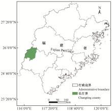
Fig.1
Location of study area"
Table 1
Description of remote sensing images"
| 获取日期 Data acquired | 卫星 Satellite | 影像质量 Image quality |
| 2000-09-15 | Landsat5 | 1%云覆盖1% cloud cover |
| 2001-10-20 | Landsat5 | 高High |
| 2002-11-08 | Landsat5 | 高High |
| 2003-10-26 | Landsat5 | 高High |
| 2004-10-28 | Landsat5 | 高High |
| 2005-10-31 | Landsat5 | 1%云覆盖1% cloud cover |
| 2006-11-03 | Landsat5 | 高High |
| 2007-10-05 | Landsat5 | 1%云覆盖1% cloud cover |
| 2008-11-24 | Landsat5 | 9%云覆盖9% cloud cover |
| 2009-10-10 | Landsat5 | 4%云覆盖4% cloud cover |
| 2010-10-29 | Landsat5 | 4%云覆盖4% cloud cover |
| 2011-09-14 | Landsat5 | 7%云覆盖7% cloud cover |
| 2013-10-05 | Landsat8 | 高High |
| 2014-10-08 | Landsat8 | 高High |
| 2016-09-27 | Landsat8 | 高High |
Table 2
Parameters used in LandTrendr"
| 过程Step | 参数Parameter | 参数值Value |
| 分割Seg- mentation | 最少所需影像Min-image | 6 |
| Kernelsize | 3 | |
| 最大分段数Max-segments | 5 | |
| 噪声值Despike | 0.9 | |
| 恢复率Recovery_threshold | 0.5 | |
| 最优模型比例Optimal model ratio | 0.75 | |
| 滤波Filter | 1年植被覆盖损失阈值Pct_veg_loss1 | 10 |
| 10年植被覆盖损失Pct_veg_loss10 | 3 | |
| 干扰前覆盖阈值Pre_dist_cover | 20 | |
| 植被生长比例阈值Pct_veg_gain | 5 | |
| 制图Mapping | 最小制图单位Min-mapping | 21 pixel |

Fig.2
The LandTrendr segmentation process"
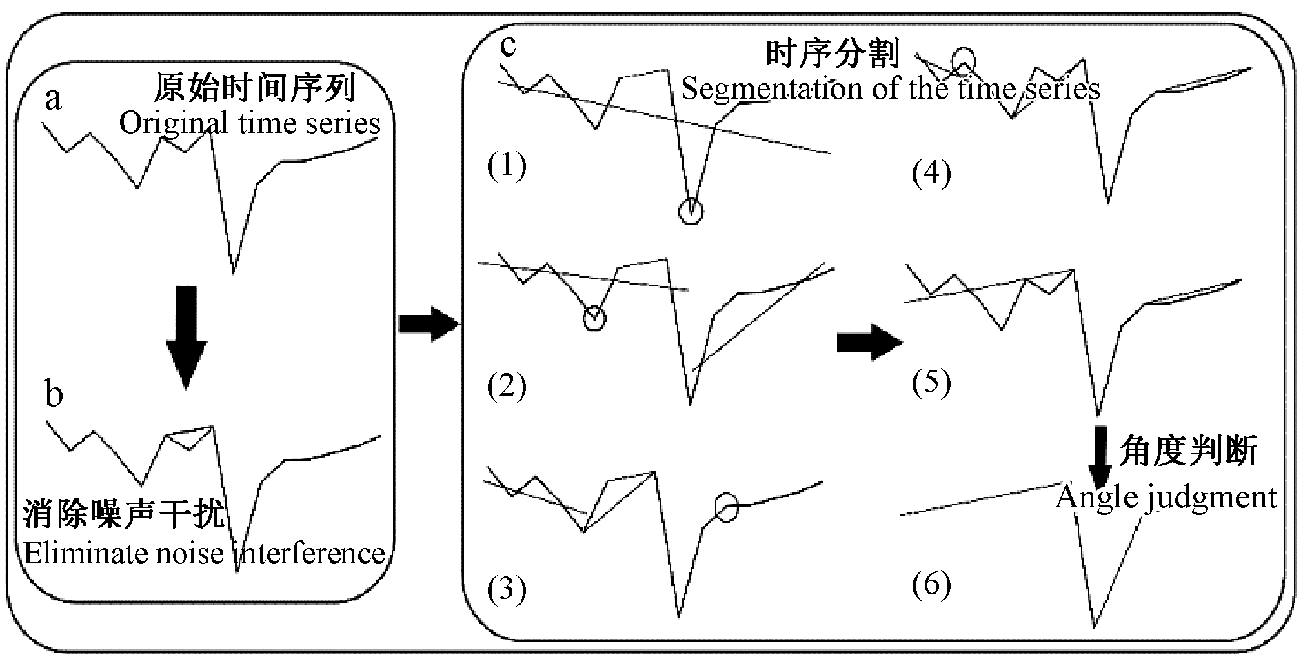
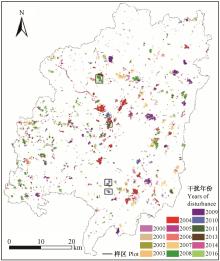
Fig.3
The distribution of forest disturbance from 2000 to 2016 in Changting county"

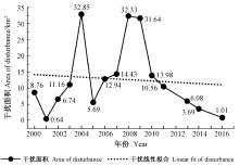
Fig.4
Temporal features of forest disturbance areas versus time in Changting county"

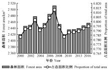
Fig.5
The forest area and proportion of total area in Changting county over the years"
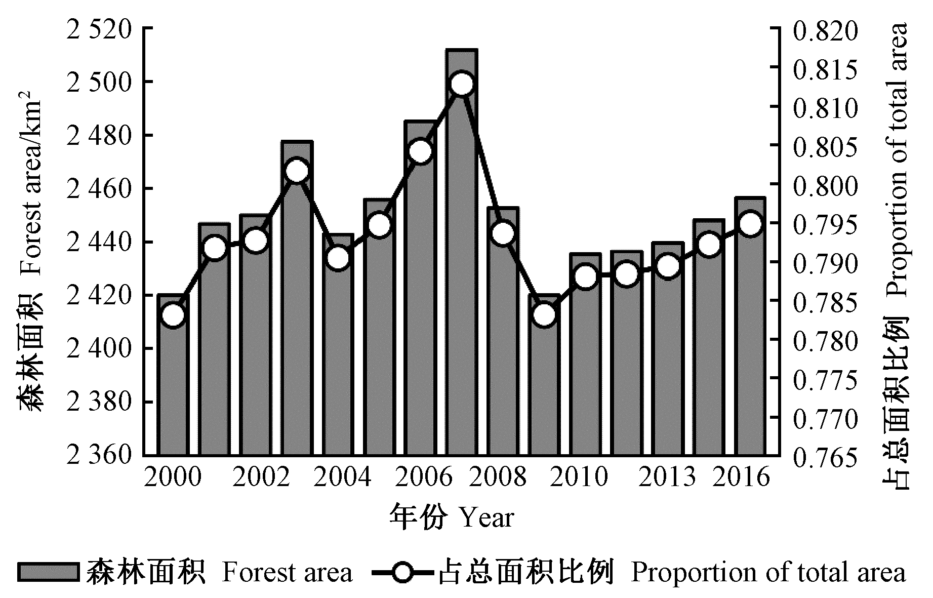
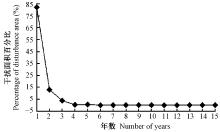
Fig.6
The distribution of forest disturbance area with duration in Changting county"

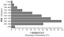
Fig.7
The distribution of forest disturbance area changing with altitude in Changting county"

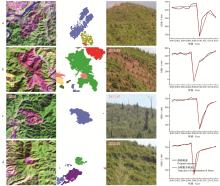
Fig.8
Field survey of forest disturbance in Changting county"

Table 3
Confusion matrix"
| 森林 Forest | 非森林 Non-forest | 2000 | 2001 | 2002 | 2003 | 2004 | 2005 | 2006 | 2007 | 2008 | 2009 | 2010 | 2011 | 2013 | 2014 | 2016 | 总计 Total(%) | 用户精度 User precision(%) | |
| 森林Forest | 69.224 | 1.294 | 0.022 | 0.067 | 0.089 | 0.133 | 0.089 | 0.245 | 0.133 | 0.022 | 0.022 | 0.044 | 0.067 | 0.022 | 71.492 | 96.86 | |||
| 非森林Non-forest | 0.802 | 21.478 | 22.280 | 96.40 | |||||||||||||||
| 2000 | 0.029 | 0.002 | 0.251 | 0.001 | 0.283 | 88.62 | |||||||||||||
| 2001 | 0.001 | 0.019 | 0.001 | 0.021 | 90.00 | ||||||||||||||
| 2002 | 0.012 | 0.206 | 0.218 | 94.34 | |||||||||||||||
| 2003 | 0.020 | 0.002 | 0.001 | 0.334 | 0.004 | 0.361 | 92.40 | ||||||||||||
| 2004 | 0.161 | 0.004 | 0.895 | 0.003 | 1.063 | 84.18 | |||||||||||||
| 2005 | 0.012 | 0.002 | 0.164 | 0.005 | 0.184 | 89.18 | |||||||||||||
| 2006 | 0.030 | 0.002 | 0.380 | 0.006 | 0.419 | 90.82 | |||||||||||||
| 2007 | 0.014 | 0.003 | 0.002 | 0.414 | 0.034 | 0.467 | 88.68 | ||||||||||||
| 2008 | 0.010 | 0.968 | 0.067 | 1.046 | 92.59 | ||||||||||||||
| 2009 | 0.124 | 0.001 | 0.887 | 0.012 | 1.024 | 86.60 | |||||||||||||
| 2010 | 0.003 | 0.003 | 0.394 | 0.001 | 0.452 | 87.10 | |||||||||||||
| 2011 | 0.040 | 0.001 | 0.292 | 0.006 | 0.001 | 0.342 | 85.54 | ||||||||||||
| 2013 | 0.004 | 0.001 | 0.190 | 0.001 | 0.197 | 96.52 | |||||||||||||
| 2014 | 0.004 | 0.112 | 0.003 | 0.119 | 93.68 | ||||||||||||||
| 2016 | 0.001 | 0.032 | 0.032 | 97.87 | |||||||||||||||
| 总计 Total(%) | 70.565 | 22.795 | 0.273 | 0.020 | 0.208 | 0.400 | 0.988 | 0.167 | 0.521 | 0.509 | 0.127 | 1.087 | 0.428 | 0.314 | 0.241 | 0.181 | 0.057 | 100.000 | 总体精度 Overall precision:96.26 |
| 生产者精度Producer precision(%) | 98.13 | 94.22 | 91.96 | 93.10 | 99.01 | 83.36 | 90.62 | 98.35 | 72.99 | 81.38 | 77.66 | 81.57 | 92.13 | 93.01 | 78.92 | 61.74 | 55.42 | Kappa:0.92 |
|
曹坤芳, 常杰. 突发气象灾害的生态效应:2008年中国南方特大冰雪灾害对森林生态系统的破坏. 植物生态学报, 2010. 34 (2): 123- 124.
doi: 10.3773/j.issn.1005-264x.2010.02.002 |
|
|
Cao K F , Chang J . The ecological effects of an unusual climatic disaster:the destruction to forest ecosystem by the extremely heavy glaze and snow storms occurred in early 2008 in southern China. Journal of Plant Ecology, 2010. 34 (2): 123- 124.
doi: 10.3773/j.issn.1005-264x.2010.02.002 |
|
|
葛全胜, 戴君虎, 何凡能, 等. 过去300年中国土地利用、土地覆被变化与碳循环研究. 中国科学, 2008. 38 (2): 197- 210.
doi: 10.3321/j.issn:1006-9267.2008.02.006 |
|
|
Ge Q S , Dai J H , He F N , et al. Research about land use, land cover change and carbon cycle over the past 300 years in China. Science China, 2008. 38 (2): 197- 210.
doi: 10.3321/j.issn:1006-9267.2008.02.006 |
|
|
江帆, 肖秀珠, 张红梅, 等. 长汀县森林火灾与气象条件的关系分析. 闽西职业技术学院学报, 2015. 17 (3): 106- 108.
doi: 10.3969/j.issn.1673-4823.2015.03.026 |
|
|
Jiang F , Xiao X Z , Zhang H M , et al. Analysis of relationship between forest fire and meteorological conditions in Changting county. Journal of Minxi Vocational and Technical College, 2015. 17 (3): 106- 108.
doi: 10.3969/j.issn.1673-4823.2015.03.026 |
|
|
李维长. 世界森林资源保护及中国林业发展对策分析. 资源科学, 2000. 22 (6): 71- 76.
doi: 10.3321/j.issn:1007-7588.2000.06.016 |
|
|
Li W C . Analysis on world forest resource protection and China's forestry development policies. Resources Science, 2000. 22 (6): 71- 76.
doi: 10.3321/j.issn:1007-7588.2000.06.016 |
|
| 宋富强, 邢开雄, 刘阳, 等. 基于MODIS/NDVI的陕北地区植被动态监测与评价. 生态学报, 2011. 31 (2): 354- 363. | |
| Song F Q , Xing K X , Liu Y , et al. Monitoring and assessment of vegetation variation in Northern Shaanxi based on MODIS/NDVI. Acta Ecologica Sinica, 2011. 31 (2): 354- 363. | |
|
王强, 张勃, 戴声佩, 等. 三北防护林工程区植被覆盖变化与影响因子分析. 中国环境科学, 2012. 32 (7): 1302- 1308.
doi: 10.3969/j.issn.1000-6923.2012.07.025 |
|
|
Wang Q , Zhang B , Dai S P , et al. Changes in vegetation coverage and impact factor analysis in the Three-North shelter forest. Resources Science, 2012. 33 (7): 1302- 1308.
doi: 10.3969/j.issn.1000-6923.2012.07.025 |
|
| 杨辰, 沈润平. 森林扰动遥感监测研究进展. 国土资源遥感, 2015. 27 (1): 1- 8. | |
| Yang C , Shen R P . Research process remote sensing monitoring of forest disturbance. Remote Sensing for Land & Resources, 2015. 27 (1): 1- 8. | |
| 杨辰, 沈润平, 郁达威, 等. 利用遥感指数时间序列轨迹监测森林扰动. 遥感学报, 2013. 17 (5): 1246- 1263. | |
| Yang C , Shen R P , Yu D W , et al. Forest disturbance monitoring based on the time-series trajectory of remote sensing index. Journal of Remote Sensing, 2013. 17 (5): 1246- 1263. | |
| 赵金龙, 王泺鑫, 韩海荣, 等. 森林生态系统服务功能价值评估研究进展与趋势. 生态学杂志, 2013. 32 (8): 2229- 2237. | |
| Zhao J L , Wang L X , Han H R , et al. Research advances and trends in forest ecosystem services value evaluation. Chinese Journal of Ecology, 2013. 32 (8): 2229- 2237. | |
| Cohen W B , Yang Z , Kennedy R . Detecting trends in forest disturbance and recovery using yearly Landsat time series:2.TimeSync-Tools for calibration and validation. Remote Sensing of Environment, 2010. 114 (12): 2911- 2924. | |
| Coppin P R , Bauer M E . Change detection in forest ecosystems with remote sensing digital imagery. British Journal of Psychiatry the Journal of Mental Science, 1996. 200 (2): 161- 161. | |
|
Derose R J , Long J N , Ramsey R D . Combining dendrochronological data and the disturbance index to assess Engelmann spruce mortality caused by a spruce beetle outbreak in southern Utah, USA. Remote Sensing of Environment, 2011. 115 (9): 2342- 2349.
doi: 10.1016/j.rse.2011.04.034 |
|
| Fahey T J , Woodbury P B , Battles J , et al. Forest carbon storage:ecology, management, and policy. Frontiers in Ecology & the Environment, 2010. 8 (5): 245- 252. | |
| Goward S N , Masek J G , Cohen W , et al. Forest disturbance and north American carbon flux. EOS Transactions American Geophysical Union, 2013. 89 (28): 105- 106. | |
| Hostert P , Röder A , Hill J . Coupling spectral unmixing and trend analysis for monitoring of long-term vegetation dynamics in Mediterranean rangelands. Remote Sensing of Environment, 2003. 87 (2/3): 183- 197. | |
|
Huang C Q , Goward S N , Schleeweis K , et al. Dynamics of national forests assessed using the Landsat record:case studies in eastern United States. Remote Sensing of Environment, 2009. 113 (7): 1430- 1442.
doi: 10.1016/j.rse.2008.06.016 |
|
|
Huang C , Wylie B , Yang L , et al. Derivation of a tasseled cap transformation based on Landsat 7 at-satellite reflectance. International Journal of Remote Sensing, 2002. 23 (8): 1741- 1748.
doi: 10.1080/01431160110106113 |
|
|
Jamali S , Jönsson P , Eklundh L , et al. Detecting changes in vegetation trends using time series segmentation. Remote Sensing of Environment, 2015. 156, 182- 195.
doi: 10.1016/j.rse.2014.09.010 |
|
| Kennedy R E , Yang Z Q , Cohen W B . Detecting trends in forest disturbance and recovery using yearly Landsat time series:1.LandTrendr-temporal segmentation algorithms. Remote Sensing of Environment, 2010. 114 (12): 2897- 2910. | |
|
Masek J G , Huang C , Wolfe R , et al. North American forest disturbance mapped from a decadal Landsat record. Remote Sensing of Environment, 2008. 112 (6): 2914- 2926.
doi: 10.1016/j.rse.2008.02.010 |
|
| Sulla-Menashe D , Kennedy R E , Yang Z , et al. Detecting forest disturbance in the Pacific Northwest from MODIS time series using temporal segmentation. Remote Sensing of Environment, 2014. 151 (8): 114- 123. | |
|
Townshend J R , Masek J G , Huang C , et al. Global characterization and monitoring of forest cover using Landsat data:opportunities and challenges. International Journal of Digital Earth, 2012. 5 (5): 373- 397.
doi: 10.1080/17538947.2012.713190 |
|
|
Verbesselt J , Hyndman R , Newnham G , et al. Detecting trend and seasonal changes in satellite image time series. Remote Sensing of Environment, 2010. 114 (1): 106- 115.
doi: 10.1016/j.rse.2009.08.014 |
|
| Woodcock C E , Allen R , Anderson M , et al. Free access to Landsat imagery. Science, 2008. 320 (5879): 1011. | |
| Wulder M A , White J C , Loveland T R , et al. The global Landsat archive:status, consolidation, and direction. Remote Sensing of Environment, 2015. 185, 271- 283. | |
| Zhu Z , Woodcock C E . Object-based cloud and cloud shadow detection in Landsat imagery. Remote Sensing of Environment, 2012. 118 (6): 83- 94. |
| [1] | Shu Qi, Hu Xuan, Xu Ruijing, Shang Ze, Qi Lianghua. Population Structure and Dynamics of Vatica mangachapoi in Ganshiling, Hainan Island, China [J]. Scientia Silvae Sinicae, 2020, 56(5): 160-167. |
| [2] | Wei Song,Chao Gao,Yue Zhao,Yandong Zhao. Method of Filling the Missing Water Loss Data of Living Plant Stem by Sequence Based on LSTM [J]. Scientia Silvae Sinicae, 2020, 56(2): 134-141. |
| [3] | Mao Xuegang, Yao Yao, Fan Wenyi. Extraction of Forest Disturbance Parameters and Estimation of Forest Height Based on Long Time-Series Landsat [J]. Scientia Silvae Sinicae, 2019, 55(3): 79-87. |
| [4] | Li Yangguang, Du Huaqiang, Mao Fangjie, Li Xuejian, Cui Lu, Han Ning, Xu Xiaojun. Information Extracting and Spatiotemporal Evolution of Bamboo Forest Based on Landsat Time Series Data in Zhejiang Province [J]. Scientia Silvae Sinicae, 2019, 55(3): 88-96. |
| [5] | Tang Mengping, Shen Lifen, Zhao Saisai, Qiu Jianxi, Xu Wenbing, Pang Chunmei, Zhao Mingshui, Mei Aijun. Growth Cycle of Phyllostachys edulis Stand in Tianmu Mountain Based on Spectrum Analysis [J]. Scientia Silvae Sinicae, 2014, 50(9): 184-188. |
| [6] | Liu Lijuan;;Pang Yong;Zhang Xiaoyang;Svein Solberg;Fan Wenyi;Li Zengyuan;Li Mingze. Monitoring Forest Growth Disturbance Using Time Series MODIS EVI Data [J]. Scientia Silvae Sinicae, 2012, 48(2): 54-62. |
| [7] | Li Chunming;Tang Shouzheng. The Basal Area Model of Mixed Stands of Larix olgensis, Abies nephrolepis and Picea jezoensis Based on Nonlinear Mixed Model [J]. Scientia Silvae Sinicae, 2010, 46(7): 106-113. |
| [8] | Pan Cunde. A STUDY ON THE DYNAMIC MODELS FOR PREDICTING DIAMETER DISTRIBUTION OF FOREST TREE [J]. , 1990, 26(5): 470-474. |
| Viewed | ||||||
|
Full text |
|
|||||
|
Abstract |
|
|||||