
林业科学 ›› 2025, Vol. 61 ›› Issue (4): 56-68.doi: 10.11707/j.1001-7488.LYKX20240473
徐有城1( ),万兴永3,陈兵4,赵凤君5,刘晓东6,叶江霞2,*()
收稿日期:2024-08-06
出版日期:2025-04-25
发布日期:2025-04-21
通讯作者:
叶江霞
E-mail:441804900@qq.com;yjx125@163.com
基金资助:
Youcheng Xu1(),Xingyong Wan3,Bing Chen4,Fengjun Zhao5,Xiaodong Liu6,Jiangxia Ye2,*()
Received:2024-08-06
Online:2025-04-25
Published:2025-04-21
Contact:
Jiangxia Ye
E-mail:441804900@qq.com;yjx125@163.com
摘要:
目的: 根据山地微环境及其与风速互作机理进行精细化风速场模拟,探究其对林火蔓延精度的影响,为林火科学防控提供参考。方法: 以云南省2006年安宁“3.29”火场为研究对象,分析影响林火蔓延的关键气象驱动因子,并在30 m空间尺度上进行风速场GIS地理模拟。基于元胞自动机理论,结合毛贤敏修正的王正非林火蔓延经验模型,实现林火蔓延模拟,通过与历史火场档案及常规反距离权重和克里金内插方法的气象模拟结果进行比较,评估模拟精度。结果: 1) 基于机理模型分析的风速驱动因子表明,风速与海拔呈正相关,与坡度、地形起伏度、地表粗糙度和地表温度呈负相关。利用多元线性回归分析构建的30 m空间尺度的平均风速场显示,火灾发生区周围平均风速场最大风速为3.70 m·s?1、最小为0.28 m·s?1。2) 结合火场周围地形及可燃物数据,模拟3月30日—4月3日的火灾发生过程,以火灾历史档案逐日火线范围为参考,精度验证结果表明,基于精细化风速场模拟的结果在不同时间段内均表现出较高的模拟精度,其中4月1日的模拟结果最优,S?rensen系数和重合精度分别为0.83和93.28%,3月30日的模拟结果精度相对较低,S?rensen系数和重合精度分别为0.65和80%。与2组插值风速场模拟结果相比,基于精细化风速场模拟结果的重合精度和SC系数分别最大提高6.67%、11.67%和0.11、0.08。结论: 与常规反距离权重和克里金内插方法相比,模拟的30 m尺度风速场数据在空间异质性和连续性方面表现更佳,能够更精细反映山地风速场的空间格局,有效提高林火蔓延模拟精度。本研究综合考虑宏观气象条件和微观地表特征,利用GIS空间建模对影响林火蔓延的关键驱动因子进行精细化刻画,实现了更精准的林火蔓延模拟。
中图分类号:
徐有城,万兴永,陈兵,赵凤君,刘晓东,叶江霞. 基于精细化风速场模拟的山地林火蔓延[J]. 林业科学, 2025, 61(4): 56-68.
Youcheng Xu,Xingyong Wan,Bing Chen,Fengjun Zhao,Xiaodong Liu,Jiangxia Ye. Simulation of Mountain Forest Fire Spread Based on Refined Wind Speed Field[J]. Scientia Silvae Sinicae, 2025, 61(4): 56-68.

图1
研究区概况 a. 安宁“3.29”火场 3 月 29 日—4 月 3 日每日火线范围 Anning“3.29”fire March 29?April 3 daily fire line range;b. 火场树种分布 Map of tree species in the fire zone."
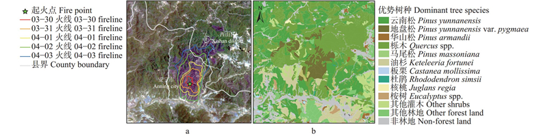
表1
3月29日—4月2日气象站平均风速和风向观测信息①"
| 区站号 Area station number | 站点 Station | 平均风速Mean wind speed/(m·s-1) | 风向 Wind direction | ||||||||||
| 03?29 | 03?30 | 03?31 | 04?01 | 04?02 | 03?29 | 03?30 | 03?31 | 04?01 | 04?02 | ||||
| 1 | 56863 | 安宁市 Anning City | 2.0 | 2.0 | 2.7 | 1.3 | 2.7 | 8 | 12 | 15 | 7 | 7 | |
| 2 | 56772 | 富民县 Fumin County | 3.0 | 2.3 | 2.3 | 1.3 | 2.0 | 14 | 9 | 6 | 10 | 0 | |
| 3 | 56774 | 武定县Wuding County | 3.3 | 2.0 | 2.7 | 1.0 | 3.0 | 0 | 0 | 0 | 0 | 0 | |
| 4 | 56777 | 禄丰市 Lufeng City | 1.5 | 3.0 | 1.5 | 1.3 | 3.3 | 0 | 0 | 0 | 0 | 0 | |
| 5 | 56778 | 昆明市Kunming City | 5.5 | 4.7 | 3.8 | 2.4 | 3.9 | 13 | 11 | 7 | 15 | 12 | |
| 6 | 56870 | 易门县Yimen County | 2.0 | 3.0 | 2.0 | 0.7 | 0.7 | 0 | 0 | 0 | 0 | 0 | |
| 7 | 56871 | 晋宁区Jinning District | 3.0 | 3.3 | 3.0 | 2.0 | 3.3 | 0 | 0 | 0 | 0 | 0 | |
| 8 | 56872 | 太华山Mountain Taihua | 5.3 | 4.7 | 4.0 | 4.7 | 3.3 | 0 | 0 | 0 | 0 | 0 | |
| 9 | 56873 | 澄江市Chengjiang City | 1.7 | 1.7 | 2.0 | 1.0 | 2.0 | 0 | 0 | 0 | 0 | 0 | |
| 10 | 56882 | 呈贡区Chenggong District | 4.3 | 3.0 | 2.7 | 2.0 | 2.3 | 0 | 0 | 0 | 0 | 0 | |
| 11 | 56766 | 牟定县Mouding County | 3.0 | 2.7 | 3.3 | 1.7 | 2.0 | 0 | 0 | 0 | 0 | 0 | |
| 12 | 56768 | 楚雄市Chuxiong City | 4.6 | 3.7 | 4.3 | 2.8 | 1.8 | 14 | 12 | 12 | 12 | 12 | |
| 13 | 56862 | 双柏县Shuangbai County | 7.7 | 3.7 | 5.3 | 2.7 | 3.3 | 0 | 0 | 0 | 0 | 0 | |
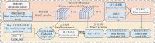
图2
山地微观环境变量对风速场干扰影响的精细化风速场建模技术路线"
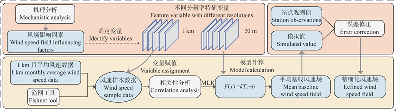
表2
可燃物配置格局系数"
| 可燃物类型 Type of combustible | KS | 可燃物类型 Type of combustible | KS | |
| 平铺松针 Flatten pine needles | 0.8 | 莎草和矮桦 Sedge and Dwarf birch | 1.8 | |
| 枯枝落叶 Withered branches and fallen leaves | 1.2 | 牧场草原 Pasture grassland | 2.0 | |
| 茅草杂草 Thatch weed | 1.6 | 红松、华山松、云南松等林地 Korean pine, Huashan pine, Yunnan pines and other forest | 1.0 |
表3
8个邻域方向元胞蔓延速度分量"
| 邻域方向 Neighborhood direction | 蔓延速度分量 Spreading speed component | 邻域方向 Neighborhood direction | 蔓延速度分量 Spreading speed component | |
| 左上 Top left | 右下 Lower right | |||
| 上Top | 下Lower | |||
| 右上Top right | 左下Lower left | |||
| 右Right | 左Left |
图3
风速场与特征变量间相关性分析矩阵"

表4
模型系数及检验①"
| 项目 Items | 未标准化系数 Unstandardized coefficient | Beta | t 检验 t-test | P | VIF | R | R2 |
| 常量Constant variable | 2.680 7 | — | 43.625 | 0.000 | — | — | — |
| 海拔Elevation | 0.000 4 | 0.691 | 123.475 | 0.000 | 1.993 | 0.618A | 0.382 |
| 地形起伏度Degree of relief | ?0.000 5 | ?0.236 | ?42.973 | 0.000 | 1.918 | 0.733B | 0.537 |
| 地表温度Surface temperature | 0.013 8 | 0.099 | 10.424 | 0.000 | 5.754 | 0.752C | 0.566 |
| 地表粗糙度 Surface roughness | ?0.696 7 | ?0.056 | ?11.131 | 0.000 | 1.632 | 0.753D | 0.567 |
| 坡度Slope | 0.004 9 | ?0.451 | ?49.275 | 0.000 | 5.331 | 0.754E | 0.568 |
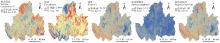
图4
安宁市及其邻县30 m分辨率特征变量格局"
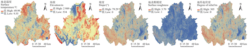
图5
30 m分辨率基线风速场模拟结果 a. 30 m 分辨率基线风速场 30 m resolution baseline wind speed field;b. 观测值与模拟值对比结果 Comparison of observed and simulated results."
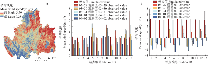
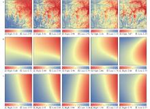
图6
火场周围3组平均风速场格局 图中3组平均风速场格局单位均为m·s−1。The units of the 3 sets of mean wind speed field patterns in the figure are all m·s−1."

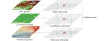
图7
栅格数据存储原理"

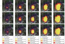
图8
3组风速场数据蔓延模拟结果"
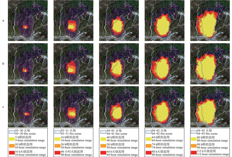
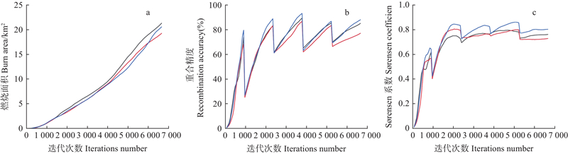
表5
3组风速场数据林火蔓延结果统计①"
| 项目 Item | 模拟时间 Simulation time | 实际燃烧面积 Actual burned area/km2 | 模拟燃烧面积 Simulated burned area/km2 | a/km2 | b/km2 | c/km2 | 重合精度 Recombination accuracy (%) | S?rensen |
| 精细化风速场 Refined wind speed field | 03?30 | 0.60 | 0.88 | 0.48 | 0.40 | 0.12 | 80.00 | 0.65 |
| 03?31 | 3.83 | 4.33 | 3.41 | 0.92 | 0.42 | 89.03 | 0.84 | |
| 04?01 | 6.55 | 8.23 | 6.11 | 2.12 | 0.44 | 93.28 | 0.83 | |
| 04?02 | 13.05 | 13.43 | 11.35 | 2.08 | 1.70 | 86.97 | 0.86 | |
| 04?03 | 17.26 | 20.60 | 15.22 | 5.38 | 2.04 | 88.18 | 0.80 | |
| IDW插值风速场 IDW interpolated wind speed field | 03?30 | 0.60 | 0.84 | 0.44 | 0.40 | 0.16 | 73.33 | 0.61 |
| 03?31 | 3.83 | 4.91 | 3.18 | 1.73 | 0.65 | 83.03 | 0.73 | |
| 04?01 | 6.55 | 8.76 | 5.86 | 2.90 | 0.69 | 89.47 | 0.77 | |
| 04?02 | 13.05 | 15.54 | 11.17 | 4.37 | 1.88 | 85.59 | 0.78 | |
| 04?03 | 17.26 | 21.34 | 14.71 | 6.63 | 2.55 | 85.23 | 0.76 | |
| Kriging插值风速场 Kriging interpolated wind speed field | 03?30 | 0.60 | 0.84 | 0.41 | 0.43 | 0.19 | 68.33 | 0.57 |
| 03?31 | 3.83 | 4.18 | 3.19 | 0.99 | 0.64 | 83.29 | 0.80 | |
| 04?01 | 6.55 | 8.35 | 5.68 | 2.67 | 0.87 | 86.72 | 0.76 | |
| 04?02 | 13.05 | 14.22 | 10.90 | 3.32 | 2.15 | 83.52 | 0.80 | |
| 04?03 | 17.26 | 19.28 | 13.33 | 5.95 | 3.93 | 77.23 | 0.73 |
图9
3组风速场数据模拟蔓延结果变化趋势 :精细化风速场模拟结果The refined wind speed field simulation result;:IDW插值风速场模拟结果The IDW interpolated wind speed field simulation result;:Kriging插值风速场模拟结果The Kriging interpolated wind speed field simulation result."
| 曹国军, 李嘉昕, 赵凤君, 等. 森林计划烧除的PM2.5排放时空过程模拟及其对空气质量的影响. 林业科学, 2022, 58 (8): 63- 75. | |
| Cao G J, Li J X, Zhao F J, et al. Simulation of the spatiotemporal process of PM2.5 emission from prescribed burning of forest and its impacts on air quality. Scientia Silvae Sinicae, 2022, 58 (8): 63- 75. | |
|
陈 兵, 赵凤君, 范太云, 等. 西昌市森林防火综合阻隔网空间布局. 林业科学, 2023, 59 (9): 127- 138.
doi: 10.11707/j.1001-7488.LYKX20220880 |
|
|
Chen B, Zhao F J, Fan T Y, et al. Spatial distribution of forest fire prevention comprehensive obstructing network in Xichang City. Scientia Silvae Sinicae, 2023, 59 (9): 127- 138.
doi: 10.11707/j.1001-7488.LYKX20220880 |
|
| 董志南, 郑拴宁, 赵会兵, 等. 基于空间插值的风场模拟方法比较分析. 地球信息科学学报, 2015, 17 (1): 37- 44. | |
| Dong Z N, Zheng S N, Zhao H B, et al. Comparative analysis of methods of wind field simulation based on spatial interpolation. Journal of Geo-Information Science, 2015, 17 (1): 37- 44. | |
| 冯 林, 傅 军, 施红辉, 等. 山体地形中粗糙度对风速的影响研究. 太阳能学报, 2018, 39 (12): 3577- 3583. | |
| Feng L, Fu J, Shi H H, et al. Study on influence of roughness on wind speed in mountain terrain. Acta Energiae Solaris Sinica, 2018, 39 (12): 3577- 3583. | |
| 高 超, 林红蕾, 胡海清, 等. 我国林火发生预测模型研究进展. 应用生态学报, 2020, 31 (9): 3227- 3240. | |
| Gao C, Lin H L, Hu H Q, et al. A review of models of forest fire occurrence prediction in China. Chinese Journal of Applied Ecology, 2020, 31 (9): 3227- 3240. | |
| 金 森, 王晓红, 于宏洲. 林火行为预测和森林火险预报中气象场的插值方法. 中南林业科技大学学报, 2012, 32 (6): 1- 7. | |
| Jin S, Wang X H, Yu H Z. A review on weather data interpolation methods used in forest fire danger forecast and behavior modelling. Journal of Central South University of Forestry & Technology, 2012, 32 (6): 1- 7. | |
|
巨文珍, 韩斐扬, 彭泊林, 等. 广西林火发生动态及气象影响因素研究. 森林工程, 2024, 40 (2): 77- 84.
doi: 10.3969/j.issn.1006-8023.2024.02.009 |
|
|
Ju W Z, Han F Y, Peng B L, et al. Study on the dynamics and meteorological influencing factors of forest fire in Guangxi. Forest Engineering, 2024, 40 (2): 77- 84.
doi: 10.3969/j.issn.1006-8023.2024.02.009 |
|
|
李春梅, 孟庆祥, 崔卫红. 基于WRF模式研究动态风场对林火蔓延预测的影响: 以西昌“3·30” 森林火灾为例. 科学技术与工程, 2023, 23 (11): 4579- 4585.
doi: 10.12404/j.issn.1671-1815.2023.23.11.04579 |
|
|
Li C M, Meng Q X, Cui W H. Impact of dynamic wind flow behavior on forest fire spread using WRF model: a case study of “3·30” forest fire in Xichang. Science Technology and Engineering, 2023, 23 (11): 4579- 4585.
doi: 10.12404/j.issn.1671-1815.2023.23.11.04579 |
|
|
李 鸽, 刘 潇, 朱红春, 等. 基于元胞自动机的崂山林火蔓延模拟. 地理空间信息, 2021, 19 (12): 37- 39, 35.
doi: 10.3969/j.issn.1672-4623.2021.12.009 |
|
|
Li G, Liu X, Zhu H C, et al. Simulation of forest fire spread in Laoshan mountain based on cellular automata. Geospatial Information, 2021, 19 (12): 37- 39, 35.
doi: 10.3969/j.issn.1672-4623.2021.12.009 |
|
| 刘琰琰. 气象要素插值的空间化精度提高方法研究. 气象科学, 2017, 37 (2): 278- 282. | |
| Liu Y Y. Analysis of spatial interpolation methods for meteorological elements anomaly. Journal of the Meteorological Sciences, 2017, 37 (2): 278- 282. | |
|
吕振峰, 李恒阳, 王达达, 等. 复杂地形对风速分布影响的数值模拟研究. 能源工程, 2015, 35 (1): 31- 36.
doi: 10.3969/j.issn.1004-3950.2015.01.007 |
|
|
Lv Z F, Li H Y, Wang D D, et al. Numerical simulation study on the impact about wind speed distribution in complex terrain. Energy Engineering, 2015, 35 (1): 31- 36.
doi: 10.3969/j.issn.1004-3950.2015.01.007 |
|
| 毛贤敏. 风和地形对林火蔓延速度的作用. 应用气象学报, 1993, 4 (1): 100- 104. | |
| Mao X M. The influence of wind and relief on the speed of the forest fire spreading. Quarterly Journal of Applied Meteorology, 1993, 4 (1): 100- 104. | |
| 邵文波. 2009. 风场复杂地形流动的数值模拟及微观选址. 北京: 华北电力大学. | |
| Shao W B. 2009. Numerical simulation of flow over complex wind farm terrains and the micrositing. Beijing: North China Electric Power University. [in Chinese] | |
| 史婷婷, 杨晓梅, 张 涛, 等. 基于TRMM数据的福建省降水时空格局BME插值分析. 地球信息科学学报, 2014, 16 (3): 470- 481. | |
| Shi T T, Yang X M, Zhang T, et al. Spatiotemporal analytical research of precipitation in Fujian Province based on TRMM and BME. Journal of Geo-Information Science, 2014, 16 (3): 470- 481. | |
| 孙 园. 2023. 基于WRF与元胞自动机的林火蔓延模拟方法. 哈尔滨: 东北林业大学. | |
| Sun Y. 2023. A simulation method of forest fire spread based on WRF and cellular automata. Harbin: Northeast Forestry University. [in Chinese] | |
| 田玉萍, 金成宇, 王 斌, 等. 基于改进的王正非模型结合元胞自动机的林火蔓延预测. 中南林业科技大学学报, 2024, 44 (5): 14- 25. | |
| Tian Y P, Jin C Y, Wang B, et al. Forest fire spread prediction based on improved Wang Zhengfei model combined with cellular automata. Journal of Central South University of Forestry & Technology, 2024, 44 (5): 14- 25. | |
| 王雪姣, 王 森, 吉春容, 等. 1961—2015年新疆0cm地温的时空分布特征及突变分析. 干旱区资源与环境, 2018, 32 (4): 165- 169. | |
| Wang X J, Wang S, Ji C R, et al. Spatial-temporal characteristics and mutation analysis of ground temperature in Xinjiang from 1961 to 2015. Journal of Arid Land Resources and Environment, 2018, 32 (4): 165- 169. | |
| 王雪松, 刘 磊. 基于SRTM DEM数据的云南省地形起伏度及其与风速关系研究. 甘肃科学学报, 2019, 31 (6): 30- 35, 67. | |
| Wang X S, Liu L. Study on the land relief in Yunnan Province and its relationship with wind speed based on SRTM DEM data. Journal of Gansu Sciences, 2019, 31 (6): 30- 35, 67. | |
| 王正非. 通用森林火险级系统. 自然灾害学报, 1992, 1 (3): 39- 44. | |
| Wang Z F. Current forest fire danger rating system. Journal of Natural Disasters, 1992, 1 (3): 39- 44. | |
|
徐奔奔, 王炜烨, 陈良富, 等. 基于VIIRS火点数据和FARSITE系统的森林火灾蔓延模拟. 遥感学报, 2022, 26 (8): 1575- 1588.
doi: 10.11834/j.issn.1007-4619.2022.8.ygxb202208007 |
|
|
Xu B B, Wang W Y, Chen L F, et al. Forest fire spread simulation based on VIIRS active fire data and FARSITE model. National Remote Sensing Bulletin, 2022, 26 (8): 1575- 1588.
doi: 10.11834/j.issn.1007-4619.2022.8.ygxb202208007 |
|
|
杨福龙, 曹 佳, 白 夜. 基于元胞自动机的林火蔓延三维模拟仿真研究. 计算机工程与应用, 2016, 52 (19): 37- 41.
doi: 10.3778/j.issn.1002-8331.1508-0093 |
|
|
Yang F L, Cao J, Bai Y. Study on simulation of three dimensional simulation of forest fire spread based on cellular automaton. Computer Engineering and Applications, 2016, 52 (19): 37- 41.
doi: 10.3778/j.issn.1002-8331.1508-0093 |
|
| 杨青青, 陈小花, 陈宗铸, 等. 基于MODIS数据的海南岛森林火灾时空分布特征分析. 林业科技通讯, 2024, (1): 22- 26. | |
| Yang Q Q, Chen X H, Chen Z C, et al. Temporal and spatial distribution characteristics of forest fires in Hainan Island based on MODIS data. Forest Science and Technology, 2024, (1): 22- 26. | |
|
张金善, 钟 中, 黄 瑾. 中尺度大气模式MM5简介. 海洋预报, 2005, (1): 31- 40.
doi: 10.3969/j.issn.1003-0239.2005.01.005 |
|
|
Zhang J S, Zhong Z, Huang J. Mesoscale atmospheric model MM5 introduction. Marine Forecasts, 2005, (1): 31- 40.
doi: 10.3969/j.issn.1003-0239.2005.01.005 |
|
|
张全文, 杨永崇, 王 涛, 等. 基于元胞自动机的高原林火蔓延三维可视化模拟. 科学技术与工程, 2021, 21 (4): 1295- 1299.
doi: 10.3969/j.issn.1671-1815.2021.04.007 |
|
|
Zhang Q W, Yang Y C, Wang T, et al. Three-dimensional visual simulation of forest fire spread based on cellular automata. Science Technology and Engineering, 2021, 21 (4): 1295- 1299.
doi: 10.3969/j.issn.1671-1815.2021.04.007 |
|
| 张 威, 纪 然. 辽宁省地表温度时空变化及影响因素. 生态学报, 2019, 39 (18): 6772- 6784. | |
| Zhang W, Ji R. Analysis of spatio-temporal variation and factors influencing surface temperature in Liaoning Province. Acta Ecologica Sinica, 2019, 39 (18): 6772- 6784. | |
|
张晓磊, 赵 明, 何 屏, 等. 距地面不同高度下复杂地形对风速影响的数值模拟研究. 工业加热, 2015, 44 (6): 50- 52.
doi: 10.3969/j.issn.1002-1639.2015.06.050 |
|
|
Zhang X L, Zhao M, He P, et al. Complex terrain under different height from ground numerical simulation study of the impact of wind speed. Industrial Heating, 2015, 44 (6): 50- 52.
doi: 10.3969/j.issn.1002-1639.2015.06.050 |
|
| 赵冰雪, 王 雷, 程东亚. 安徽省气象数据空间插值方法比较与分布特征. 水土保持研究, 2017, 24 (3): 141- 145. | |
| Zhao B X, Wang L, Cheng D Y. Comparison of spatial interpolation method for meteorological data and distribution characteristic in Anhui province. Research of Soil and Water Conservation, 2017, 24 (3): 141- 145. | |
| 赵 璠, 舒立福, 周汝良, 等. 西南林区森林火灾火行为模拟模型评价. 应用生态学报, 2017, 28 (10): 3144- 3154. | |
| Zhao F, Shu L F, Zhou R L, et al. Evaluating fire behavior simulators in southwestern China forest area. Chinese Journal of Applied Ecology, 2017, 28 (10): 3144- 3154. | |
| 赵 亮, 刘鹏举, 周宇飞, 等. 复杂地形下风场插值与林火蔓延模拟应用研究. 北京林业大学学报, 2010, 32 (4): 12- 16. | |
| Zhao L, Liu P J, Zhou Y F, et al. Wind field interpolation over complex terrain and its application in the simulation of forest fire spreading. Journal of Beijing Forestry University, 2010, 32 (4): 12- 16. | |
|
甄 贞, 赵颖慧, 李凤日. 基于GIS森林火险等级预报系统数据处理技术. 东北林业大学学报, 2009, 37 (11): 113- 117.
doi: 10.3969/j.issn.1000-5382.2009.11.037 |
|
|
Zhen Z, Zhao Y H, Li F R. Data processing techniques for GIS-based forecasting system of forest fire weather ranks. Journal of Northeast Forestry University, 2009, 37 (11): 113- 117.
doi: 10.3969/j.issn.1000-5382.2009.11.037 |
|
| 智协飞, 吴柏莹, 罗忠红, 等. 华东地区地面和高空风场的多模式集成精细化预报研究. 大气科学学报, 2023, 46 (6): 917- 927. | |
| Zhi X F, Wu B Y, Luo Z H, et al. Multimodel ensemble forecasts of high-resolution surface and high-level wind forecasts over East China. Transactions of Atmospheric Sciences, 2023, 46 (6): 917- 927. | |
| 周宇飞, 刘鹏举, 唐小明. 林火蔓延模型模拟空间精度评价研究. 北京林业大学学报, 2010, 32 (2): 21- 26. | |
| Zhou Y F, Liu P J, Tang X M. Space accuracy evaluation of forest fire spreading model. Journal of Beijing Forestry University, 2010, 32 (2): 21- 26. | |
|
Ali A A, Carcaillet C, Bergeron Y. Long-term fire frequency variability in the eastern Canadian boreal forest: the influences of climate vs. local factors. Global Change Biology, 2009, 15 (5): 1230- 1241.
doi: 10.1111/j.1365-2486.2009.01842.x |
|
|
Bountzouklis C, Fox D M, Di Bernardino E. Environmental factors affecting wildfire-burned areas in south-eastern France, 1970-2019. Natural Hazards and Earth System Sciences, 2022, 22, 1181- 1200.
doi: 10.5194/nhess-22-1181-2022 |
|
| Byari M, Bernoussi A, Jellouli O, et al. 2022. Multi-scale 3D cellular automata modeling: Application to wildland fire spread. Chaos, Solitons & Fractals, 164: 112653. | |
| Collin A, Bernardin D, Séro-Guillaume O. A physical-based cellular automaton model for forest-fire propagation. Combustion Science and Technology, 2011, 183, 347- 369. | |
| Doerr S H, Santín C. 2016. Global trends in wildfire and its impacts: perceptions versus realities in a changing world. Philosophical Transactions of the Royal Society of London Series B, Biological Sciences, 371(1696): 20150345 | |
|
Encinas A H, Encinas L H, White S H, et al. Simulation of forest fire fronts using cellular automata. Advances in Engineering Software, 2007, 38 (6): 372- 378.
doi: 10.1016/j.advengsoft.2006.09.002 |
|
|
Farguell À, Cortés A, Margalef T, et al. Data resolution effects on a coupled data driven system for forest fire propagation prediction. Procedia Computer Science, 2017, 108, 1562- 1571.
doi: 10.1016/j.procs.2017.05.044 |
|
|
Flannigan M D, Krawchuk M A, de Groot W J, et al. Implications of changing climate for global wildland fire. International Journal of Wildland Fire, 2009, 18 (5): 483.
doi: 10.1071/WF08187 |
|
|
Hassan A, Accary G, Sutherland D, et al. Physics-based modelling of wind-driven junction fires. Fire Safety Journal, 2024, 142, 104039.
doi: 10.1016/j.firesaf.2023.104039 |
|
|
He J W, Zhang H F, Zhou L. Numerical simulation of wind characteristics in complex mountains with focus on terrain boundary transition curve. Atmosphere, 2023, 14 (2): 230.
doi: 10.3390/atmos14020230 |
|
|
Hoadley J L, Rorig M L, Bradshaw L, et al. Evaluation of MM5 model resolution when applied to prediction of National Fire Danger Rating indexes. International Journal of Wildland Fire, 2006, 15 (2): 147- 154.
doi: 10.1071/WF05015 |
|
|
Hong H Y, Tsangaratos P, Ilia I, et al. Applying genetic algorithms to set the optimal combination of forest fire related variables and model forest fire susceptibility based on data mining models. The case of Dayu County, China. The Science of the Total Environment, 2018, 630, 1044- 1056.
doi: 10.1016/j.scitotenv.2018.02.278 |
|
|
Jellouli O, Bernoussi A S. The impact of dynamic wind flow behavior on forest fire spread using cellular automata: Application to the watershed BOUKHALEF (Morocco). Ecological Modelling, 2022, 468, 109938.
doi: 10.1016/j.ecolmodel.2022.109938 |
|
|
Kim Y H, Bettinger P, Finney M. Spatial optimization of the pattern of fuel management activities and subsequent effects on simulated wildfires. European Journal of Operational Research, 2009, 197 (1): 253- 265.
doi: 10.1016/j.ejor.2008.05.025 |
|
|
Kumar S, Kumar A. Hotspot and trend analysis of forest fires and its relation to climatic factors in the western Himalayas. Natural Hazards, 2022, 114 (3): 3529- 3544.
doi: 10.1007/s11069-022-05530-5 |
|
| Lawson B, Stocks B, Alexander M, et al. 1985. A system for predicting fire behavior in Canadian forests. Eighth Conference on Fire and Forest Meteorology. Society of American Foresters, Detroit. | |
| Mangiameli M, Mussumeci G, Cappello A. Forest fire spreading using free and open-source GIS technologies. Geomatics, 2021, 1, 50- 64. | |
|
Parvar Z, Saeidi S, Mirkarimi S. Integrating meteorological and geospatial data for forest fire risk assessment. Journal of Environmental Management, 2024, 358, 120925.
doi: 10.1016/j.jenvman.2024.120925 |
|
| Robinson D, Brambilla S, Oliveto J, et al. The effect of terrain-influenced winds on fire spread in QUIC-Fire. Environmental Modelling & Software, 2023, 167, 105727. | |
| Rossa C G, Fernandes P M. 2018. On the fire-spread rate influence of some fuel bed parameters derived from Rothermel’s model thermal energy balance. Šumarski list, 142(1/2): 77−80. | |
| Sá A, Benali A, Pinto R, et al. 2014. Improving wildfire spread simulations using MODIS active fires: the FIRE-MODSAT project. Advances in forest fire research, 811–822. | |
|
Sanjuan G, Brun C, Margalef T, et al. Wind field uncertainty in forest fire propagation prediction. Procedia Computer Science, 2014, 29, 1535- 1545.
doi: 10.1016/j.procs.2014.05.139 |
|
| Sun W Y, Mu X M, Song X Y, et al. Changes in extreme temperature and precipitation events in the Loess Plateau (China) during 1960-2013 under global warming. Atmospheric Research, 2016, 168, 33- 48. | |
|
Sun X, Li N, Chen D Q, et al. A forest fire prediction model based on cellular automata and machine learning. IEEE Access, 2024, 12, 55389- 55403.
doi: 10.1109/ACCESS.2024.3389035 |
|
| Tan L, de Callafon R A, Block J, et al. 2021. Improving wildfire simulations by estimation of wildfire wind conditions from fire perimeter measurements. Computational Science - ICCS 2021. Cham: Springer International Publishing: 231−244. | |
|
Tian Y P, Wu Z C, Li M Z, et al. Forest fire spread monitoring and vegetation dynamics detection based on multi-source remote sensing images. Remote Sens, 2022, 14 (18): 4431.
doi: 10.3390/rs14184431 |
|
|
Viedma O, Chico F, Fernández J J, et al. Disentangling the role of prefire vegetation vs. burning conditions on fire severity in a large forest fire in SE Spain. Remote Sensing of Environment, 2020, 247, 111891.
doi: 10.1016/j.rse.2020.111891 |
|
| William C S, Joseph B K, Jimy D, et al. 2019. A description of the advanced research WRF model version 4. National Center for Atmospheric Research, 148. | |
|
Wu Z C, Wang B, Li M Z, et al. Simulation of forest fire spread based on artificial intelligence. Ecological Indicators, 2022, 136, 108653.
doi: 10.1016/j.ecolind.2022.108653 |
|
|
Zhao J, Wang J M, Meng Y F, et al. Spatiotemporal patterns of fire-driven forest mortality in China. Forest Ecology and Management, 2023, 529, 120678.
doi: 10.1016/j.foreco.2022.120678 |
| [1] | 田静, 邢艳秋, 姚松涛, 曾旭婧, 焦义涛. 基于元胞自动机和BP神经网络算法的Landsat-TM遥感影像森林类型分类比较[J]. 林业科学, 2017, 53(2): 26-34. |
| [2] | 杨广斌;刘鹏举;唐小明. 动态数据驱动的林火蔓延模型适宜性选择[J]. 林业科学, 2011, 47(1): 107-112. |
| [3] | 陈崇成 李建微 唐丽玉 冯晓刚. 林火蔓延的计算机模拟与可视化研究进展[J]. 林业科学, 2005, 41(5): 155-162. |
| 阅读次数 | ||||||
|
全文 |
|
|||||
|
摘要 |
|
|||||