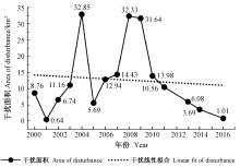
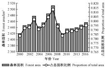
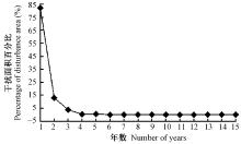
|
曹坤芳, 常杰. 突发气象灾害的生态效应:2008年中国南方特大冰雪灾害对森林生态系统的破坏. 植物生态学报, 2010. 34 (2): 123- 124.
doi: 10.3773/j.issn.1005-264x.2010.02.002
|
|
Cao K F , Chang J . The ecological effects of an unusual climatic disaster:the destruction to forest ecosystem by the extremely heavy glaze and snow storms occurred in early 2008 in southern China. Journal of Plant Ecology, 2010. 34 (2): 123- 124.
doi: 10.3773/j.issn.1005-264x.2010.02.002
|
|
葛全胜, 戴君虎, 何凡能, 等. 过去300年中国土地利用、土地覆被变化与碳循环研究. 中国科学, 2008. 38 (2): 197- 210.
doi: 10.3321/j.issn:1006-9267.2008.02.006
|
|
Ge Q S , Dai J H , He F N , et al. Research about land use, land cover change and carbon cycle over the past 300 years in China. Science China, 2008. 38 (2): 197- 210.
doi: 10.3321/j.issn:1006-9267.2008.02.006
|
|
江帆, 肖秀珠, 张红梅, 等. 长汀县森林火灾与气象条件的关系分析. 闽西职业技术学院学报, 2015. 17 (3): 106- 108.
doi: 10.3969/j.issn.1673-4823.2015.03.026
|
|
Jiang F , Xiao X Z , Zhang H M , et al. Analysis of relationship between forest fire and meteorological conditions in Changting county. Journal of Minxi Vocational and Technical College, 2015. 17 (3): 106- 108.
doi: 10.3969/j.issn.1673-4823.2015.03.026
|
|
李维长. 世界森林资源保护及中国林业发展对策分析. 资源科学, 2000. 22 (6): 71- 76.
doi: 10.3321/j.issn:1007-7588.2000.06.016
|
|
Li W C . Analysis on world forest resource protection and China's forestry development policies. Resources Science, 2000. 22 (6): 71- 76.
doi: 10.3321/j.issn:1007-7588.2000.06.016
|
|
宋富强, 邢开雄, 刘阳, 等. 基于MODIS/NDVI的陕北地区植被动态监测与评价. 生态学报, 2011. 31 (2): 354- 363.
|
|
Song F Q , Xing K X , Liu Y , et al. Monitoring and assessment of vegetation variation in Northern Shaanxi based on MODIS/NDVI. Acta Ecologica Sinica, 2011. 31 (2): 354- 363.
|
|
王强, 张勃, 戴声佩, 等. 三北防护林工程区植被覆盖变化与影响因子分析. 中国环境科学, 2012. 32 (7): 1302- 1308.
doi: 10.3969/j.issn.1000-6923.2012.07.025
|
|
Wang Q , Zhang B , Dai S P , et al. Changes in vegetation coverage and impact factor analysis in the Three-North shelter forest. Resources Science, 2012. 33 (7): 1302- 1308.
doi: 10.3969/j.issn.1000-6923.2012.07.025
|
|
杨辰, 沈润平. 森林扰动遥感监测研究进展. 国土资源遥感, 2015. 27 (1): 1- 8.
|
|
Yang C , Shen R P . Research process remote sensing monitoring of forest disturbance. Remote Sensing for Land & Resources, 2015. 27 (1): 1- 8.
|
|
杨辰, 沈润平, 郁达威, 等. 利用遥感指数时间序列轨迹监测森林扰动. 遥感学报, 2013. 17 (5): 1246- 1263.
|
|
Yang C , Shen R P , Yu D W , et al. Forest disturbance monitoring based on the time-series trajectory of remote sensing index. Journal of Remote Sensing, 2013. 17 (5): 1246- 1263.
|
|
赵金龙, 王泺鑫, 韩海荣, 等. 森林生态系统服务功能价值评估研究进展与趋势. 生态学杂志, 2013. 32 (8): 2229- 2237.
|
|
Zhao J L , Wang L X , Han H R , et al. Research advances and trends in forest ecosystem services value evaluation. Chinese Journal of Ecology, 2013. 32 (8): 2229- 2237.
|
|
Cohen W B , Yang Z , Kennedy R . Detecting trends in forest disturbance and recovery using yearly Landsat time series:2.TimeSync-Tools for calibration and validation. Remote Sensing of Environment, 2010. 114 (12): 2911- 2924.
|
|
Coppin P R , Bauer M E . Change detection in forest ecosystems with remote sensing digital imagery. British Journal of Psychiatry the Journal of Mental Science, 1996. 200 (2): 161- 161.
|
|
Derose R J , Long J N , Ramsey R D . Combining dendrochronological data and the disturbance index to assess Engelmann spruce mortality caused by a spruce beetle outbreak in southern Utah, USA. Remote Sensing of Environment, 2011. 115 (9): 2342- 2349.
doi: 10.1016/j.rse.2011.04.034
|
|
Fahey T J , Woodbury P B , Battles J , et al. Forest carbon storage:ecology, management, and policy. Frontiers in Ecology & the Environment, 2010. 8 (5): 245- 252.
|
|
Goward S N , Masek J G , Cohen W , et al. Forest disturbance and north American carbon flux. EOS Transactions American Geophysical Union, 2013. 89 (28): 105- 106.
|
|
Hostert P , Röder A , Hill J . Coupling spectral unmixing and trend analysis for monitoring of long-term vegetation dynamics in Mediterranean rangelands. Remote Sensing of Environment, 2003. 87 (2/3): 183- 197.
|
|
Huang C Q , Goward S N , Schleeweis K , et al. Dynamics of national forests assessed using the Landsat record:case studies in eastern United States. Remote Sensing of Environment, 2009. 113 (7): 1430- 1442.
doi: 10.1016/j.rse.2008.06.016
|
|
Huang C , Wylie B , Yang L , et al. Derivation of a tasseled cap transformation based on Landsat 7 at-satellite reflectance. International Journal of Remote Sensing, 2002. 23 (8): 1741- 1748.
doi: 10.1080/01431160110106113
|
|
Jamali S , Jönsson P , Eklundh L , et al. Detecting changes in vegetation trends using time series segmentation. Remote Sensing of Environment, 2015. 156, 182- 195.
doi: 10.1016/j.rse.2014.09.010
|
|
Kennedy R E , Yang Z Q , Cohen W B . Detecting trends in forest disturbance and recovery using yearly Landsat time series:1.LandTrendr-temporal segmentation algorithms. Remote Sensing of Environment, 2010. 114 (12): 2897- 2910.
|
|
Masek J G , Huang C , Wolfe R , et al. North American forest disturbance mapped from a decadal Landsat record. Remote Sensing of Environment, 2008. 112 (6): 2914- 2926.
doi: 10.1016/j.rse.2008.02.010
|
|
Sulla-Menashe D , Kennedy R E , Yang Z , et al. Detecting forest disturbance in the Pacific Northwest from MODIS time series using temporal segmentation. Remote Sensing of Environment, 2014. 151 (8): 114- 123.
|
|
Townshend J R , Masek J G , Huang C , et al. Global characterization and monitoring of forest cover using Landsat data:opportunities and challenges. International Journal of Digital Earth, 2012. 5 (5): 373- 397.
doi: 10.1080/17538947.2012.713190
|
|
Verbesselt J , Hyndman R , Newnham G , et al. Detecting trend and seasonal changes in satellite image time series. Remote Sensing of Environment, 2010. 114 (1): 106- 115.
doi: 10.1016/j.rse.2009.08.014
|
|
Woodcock C E , Allen R , Anderson M , et al. Free access to Landsat imagery. Science, 2008. 320 (5879): 1011.
|
|
Wulder M A , White J C , Loveland T R , et al. The global Landsat archive:status, consolidation, and direction. Remote Sensing of Environment, 2015. 185, 271- 283.
|
|
Zhu Z , Woodcock C E . Object-based cloud and cloud shadow detection in Landsat imagery. Remote Sensing of Environment, 2012. 118 (6): 83- 94.
|