
林业科学 ›› 2024, Vol. 60 ›› Issue (4): 1-15.doi: 10.11707/j.1001-7488.LYKX20220903
王智超1,马天天1,邵亚奎1,孙林豪2,李永华3,张晓媛4,张丽荣5,张贵6,范文义7,冯仲科1,*
收稿日期:2022-12-22
出版日期:2024-04-25
发布日期:2024-05-23
通讯作者:
冯仲科
基金资助:Zhichao Wang1,Tiantian Ma1,Yakui Shao1,Linhao Sun2,Yonghua Li3,Xiaoyuan Zhang4,Lirong Zhang5,Gui Zhang6,Wenyi Fan7,Zhongke Feng1,*
Received:2022-12-22
Online:2024-04-25
Published:2024-05-23
Contact:
Zhongke Feng
摘要:
森林观测信息的生产是支持智慧林业工作开展的基础和先导。本文以森林观测仪器技术体系的构建历史、现状和未来为切入点,以基础性公共技术的发展脉络为支撑,深入分析森林观测仪器与森林观测需求的耦合程度。传统森林观测仪器体系在时效性和准确性上已经无法满足日益发展的林业调查的需要,观测仪器存在孤立性高、难以集成、操作繁琐、效率低等问题。这主要是由于当前针对森林观测研究偏重对成熟仪器使用和数据分析,观测仪器的研发偏重算法补偿和集成第三方元件,轻物理结构设计等因素造成。面对基本测量原理鲜有更新、森林观测标准制定滞后于新型技术发展等问题,本文从对观测仪器现在和未来的联合模式进行阐述,从逻辑架构到物理技术层面上分析森林观测仪器联合模式可能在未来出现的发展状况与应用前景。最后,基于当前基础性技术发展的趋势,对可能出现的几种新形态的森林观测仪器进行推测,并以此展望在近未来可能在中国实现的一种智能森林观测体系的雏形。
中图分类号:
王智超,马天天,邵亚奎,孙林豪,李永华,张晓媛,张丽荣,张贵,范文义,冯仲科. 面向未来的中国智慧林业:观测仪器体系的演进与发展趋势[J]. 林业科学, 2024, 60(4): 1-15.
Zhichao Wang,Tiantian Ma,Yakui Shao,Linhao Sun,Yonghua Li,Xiaoyuan Zhang,Lirong Zhang,Gui Zhang,Wenyi Fan,Zhongke Feng. Future oriented Smart Forestry in China: Evolution and Development Trends of Observation Instrument Systems[J]. Scientia Silvae Sinicae, 2024, 60(4): 1-15.
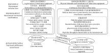
图1
当前与面向未来的林业智能观测体系框架"

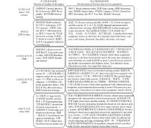
图2
林业观测装备的演变过程"

表1
逻辑联合对比表"
| 逻辑联合 Logical union | 联合形式 Union form | 应用案例 Applications | 优点 Aadvantage | 缺点 Defect |
| 地地联合 Land-land union | 不同地面观测设备联合 Combined different ground observation equipment | 森林参数提取( | 数据精度高 High data accuracy 受外界环境因素影响小 Less affected by external environmental factors | 测量范围小 Small measuring range 地形复杂地区难以进入 Areas with complex terrain are difficult to access |
| 空地联合 Air-land union | 地面观测设备与空中观测量设备的联合 Combination of ground observation equipment and air observation equipment | 林分三维建模( | 影像分辨率高 High image resolution 价格便宜 Cheap price 无人机灵活性高 High drone flexibility | 数据量大,数据处理 分析难度大 The amount of data is large and data processing and analysis is difficult 受天气条件影响 Affected by weather conditions |
| 空空联合 Air-air union | 空中观测设备的联合 Combination of air observation equipment | 亮度温度反演( Regional scale forest aboveground biomass calculation | 适合大尺度区域研究 Suitable for large-scale regional research 数据类型多样 Diverse data types 数据处理技术相对成熟 Data processing technology is relatively mature | 影像分辨率有限 Image resolution is limited 受天气条件影响 Affected by weather conditions 成本高昂 High cost |
| 曹义东, 黄卫佳, 冯天书等. 2015. GB/T 3161-2015, 光学经纬仪. 北京:中国标准出版社. | |
| Cao Y D, Huang W J, Feng T S, et al. 2015. GB/T 3161-2015, Optical Theodolite. Beijing: China Standards Press.[in Chinese] | |
| 陈金星. 2013. 基于拉绳传感器的树木直径记录仪的设计与实现. 杭州: 浙江农林大学. | |
| Chen J X. 2013. Design and implementation of a tree diameter recorder based on tape sensor. Hangzhou: Zhejiang A&F University: [in Chinese] | |
| 邓华锋. 2008. 中国森林可持续经营管理研究. 北京: 科学出版社. | |
| Deng H F. 2008. Research on sustainable forest management in China. Beijing: Science Press.[in Chinese] | |
| 丁少闻, 张小虎, 于起峰, 等. 非接触式三维重建测量方法综述. 激光与光电子学进展, 2017, 54 (7): 070003. | |
| Ding S W, Zhang X H, Yu Q F, et al. Overview of non-contact 3D reconstruction measurement methods. Laser & Optoelectronics Progress, 2017, 54 (7): 070003. | |
| 董 雪, 李永华, 辛智鸣, 等. 敦煌西湖荒漠-湿地生态系统优势物种生态位研究. 生态学报, 2020, 40 (19): 6841- 6849. | |
| Dong X, Li Y H, Xin Z M, et al. Niche of the dominant species in wetland ecosystem enclosed by extremely drydesert region in Dunhuang Xihu. Acta Ecologica Sinica, 2020, 40 (19): 6841- 6849. | |
| 方爱平,齐维君,杨俊志等. 2009. GB/T 14267-2009,光电测距仪. 北京:中国标准出版社. | |
| Fang A P, Qi W J, Yang J Z, et al. 2009. GB/T 14267-2009, Electro-optical distance meters(EDM Instruments). Beijing: China Standards Press.[in Chinese] | |
| 冯仲科, 隋宏大, 邓向瑞, 等. 三角高程法树高测量与精度分析. 北京林业大学学报, 2007, 29 (S2): 31- 35. | |
| Feng Z K, Sui H D, Deng X R, et al. Survey and precision analysis of tree height by trigonometric leveling. Journal of Beijing Forestry University, 2007, 29 (S2): 31- 35. | |
| 冯仲科, 赵春江, 聂玉藻. 2002. 精准林业 第二辑. 北京: 中国林业出版社. | |
| Feng Z K, Zhao C J, Nie Y Z. 2002. Precision Forestry Volume 2 . Beijing: China Forestry Publishing House: [in Chinese] | |
|
高 祥, 冯仲科, 王智超, 等. 基于电子经纬仪立木无损精测技术的干形指数研究. 农业机械学报, 2015, 46 (1): 299- 305.
doi: 10.6041/j.issn.1000-1298.2015.01.042 |
|
|
Gao X, Feng Z K, Wang Z C, et al. Study on stem form index based on non-destructive precision measurement through electronic theodolite. Transactions of the Chinese Society for Agricultural Machinery, 2015, 46 (1): 299- 305.
doi: 10.6041/j.issn.1000-1298.2015.01.042 |
|
|
宫 鹏. 无线传感器网络技术环境应用进展. 遥感学报, 2010, 14 (2): 387- 395.
doi: 10.11834/jrs.20100214 |
|
|
Gong P. Progress in recent environmental applications of wireless sensor networks. Journal of Remote Sensing. Journal of Remote Sensing, 2010, 14 (2): 387- 395.
doi: 10.11834/jrs.20100214 |
|
|
关 强, 尹丽丽, 李志鹏, 等. 基于超声测距的定高树径测量仪的研究. 东北林业大学学报, 2006, 34 (4): 27- 30.
doi: 10.3969/j.issn.1000-5382.2006.04.011 |
|
|
Guan Q, Yin L L, Li Z P, et al. Research of measuring instrument for tree diameter based on ultrasonic distance measurement. Journal of Northeast Forestry University, 2006, 34 (4): 27- 30.
doi: 10.3969/j.issn.1000-5382.2006.04.011 |
|
|
郭庆华, 吴芳芳, 胡天宇, 等. 无人机在生物多样性遥感监测中的应用现状与展望. 生物多样性, 2016, 24 (11): 1267- 1278.
doi: 10.17520/biods.2016105 |
|
|
Guo Q H, Wu F F, Hu T Y, et al. Perspectives and prospects of unmanned aerial vehicle in remote sensing monitoring of biodiversity. Biodiversity Science, 2016, 24 (11): 1267- 1278.
doi: 10.17520/biods.2016105 |
|
|
黄晓东, 冯仲科, 解明星, 等. 自动测量胸径和树高便携设备的研制与测量精度分析. 农业工程学报, 2015, 31 (18): 92- 99.
doi: 10.11975/j.issn.1002-6819.2015.18.014 |
|
|
Huang X D, Feng Z K, Xie M X, et al. Developing and accuracy analysis of portable device for automatically measuring diameter at breast height and tree height. Transactions of the Chinese Society of Agricultural Engineering, 2015, 31 (18): 92- 99.
doi: 10.11975/j.issn.1002-6819.2015.18.014 |
|
|
江 南, 徐卫华, 赵娟娟, 等. 城市植物地面抽样调查方法综述. 云南大学学报(自然科学版), 2021, 43 (3): 587- 597.
doi: 10.7540/j.ynu.20200567 |
|
|
Jiang N, Xu W H, Zhao J J, et al. A summary of ground sampling survey methods of urban plants. Journal of Yunnan University(Natural Sciences Edition), 2021, 43 (3): 587- 597.
doi: 10.7540/j.ynu.20200567 |
|
| 李宏韬. 2015. 基于多源遥感影像的森林植被信息提取方法研究. 北京: 北京林业大学. | |
| LI H T. 2015. Study on Extraction of Forest Vegetation Information Base on Multi-source Remote Sensing Image. Beijing: Beijing Forestry University: [in Chinese] | |
| 李亚东, 冯仲科, 李长青. USB摄像头双目视觉胸径测量实证研究. 中南林业科技大学学报, 2016, 36 (08): 1- 5. | |
| Li Y D, Feng Z K, Li C Q. Empirical study on diameter at breast height measurement of binocular vision in USB camera. Journal of Central South University of Forestry & Technology, 2016, 36 (08): 1- 5. | |
|
李增元, 刘清旺, 庞 勇. 激光雷达森林参数反演研究进展. 遥感学报, 2016, 20 (5): 1138- 1150.
doi: 10.11834/jrs.20165130 |
|
|
Li Z Y, Liu Q W, Pang Y. Review on forest parameters inversion using LiDAR. Journal of Remote Sensing, 2016, 20 (5): 1138- 1150.
doi: 10.11834/jrs.20165130 |
|
|
李增元, 张怀清, 陆元昌. 数字林业建设与进展. 中国农业科技导报, 2003, 5 (2): 7- 9.
doi: 10.3969/j.issn.1008-0864.2003.02.002 |
|
|
Li Z Y, Zhang H Q, Lu Y C. Establishment and development of digital forestry. Review of China Agricultural Science and Technology, 2003, 5 (2): 7- 9.
doi: 10.3969/j.issn.1008-0864.2003.02.002 |
|
|
林 枫. 测树电子经纬仪的性能及实用性测试分析. 辽宁林业科技, 2016, (3): 28- 29,67.
doi: 10.3969/j.issn.1001-1714.2016.03.010 |
|
|
Lin F. Performance and practicability test analysis of tree-measuring electronic theodolite. Journal of Liaoning Forestry Science & Technology, 2016, (3): 28- 29,67.
doi: 10.3969/j.issn.1001-1714.2016.03.010 |
|
|
刘金成, 冯仲科, 范永祥. 电子条码尺立木胸径自动测量研究. 农业机械学报, 2017, 48 (12): 208- 213.
doi: 10.6041/j.issn.1000-1298.2017.12.024 |
|
|
Liu J C, Feng Z K, Fan Y X. Automatic measurement of diameter at breast height with electronic bar code. Transactions of the Chinese Society for Agricultural Machinery, 2017, 48 (12): 208- 213.
doi: 10.6041/j.issn.1000-1298.2017.12.024 |
|
|
聂祥永. 瑞典国家森林资源清查的经验与借鉴. 林业资源管理, 2004, (1): 65- 70.
doi: 10.3969/j.issn.1002-6622.2004.01.017 |
|
|
Nie X Y. Experience and reference of the swedish national forest inventory. Forest Resources Management, 2004, (1): 65- 70.
doi: 10.3969/j.issn.1002-6622.2004.01.017 |
|
| 裴志永. 2010. 树木生长量无线遥测方法及装置研究. 北京: 北京林业大学. | |
| Pei Z Y. 2010. Study of Wireless Telemetry Measurement Application of Forests Biomass and its Device. Beijing: Beijing Forestry University: [in Chinese] | |
|
邱梓轩, 冯仲科, 卢 婧, 等. 望远摄影测树仪设计与试验. 农业机械学报, 2017, 48 (12): 202- 207+213.
doi: 10.6041/j.issn.1000-1298.2017.12.023 |
|
|
Qiu Z X, Feng Z K, Lu J, et al. Design and experiment of forest telescope intelligent dendrometer. Transactions of the Chinese Society for Agricultural Machinery, 2017, 48 (12): 202- 207+213.
doi: 10.6041/j.issn.1000-1298.2017.12.023 |
|
| 沈晨雁,周敏秀,王爱华等. 2011. GB/T 27663-2011, 全站仪. 北京:中国标准出版社. | |
| Shen C Y, Zhou M X, Wang A H, et al. 2011. GB/T 27663-2011, Total Station. Beijing: China Standards Press.[in Chinese] | |
|
沈亚峰, 王歆晖, 巩宇涵, 等. 基于智能手机图像分析的树木胸径测量研究. 江苏林业科技, 2017, 44 (1): 28- 33.
doi: 10.3969/j.issn.1001-7380.2017.01.006 |
|
|
Shen Y F, Wang X H, Gong Y H, et al. Study on measurement of tree diameter size based on smartphone image analysis. Journal of Jiangsu Forestry Science & Technology, 2017, 44 (1): 28- 33.
doi: 10.3969/j.issn.1001-7380.2017.01.006 |
|
| 孙林豪, 方陆明, 唐丽华, 等. 便携式树木胸径测量系统的研制. 北京林业大学学报, 2018, 40 (9): 82- 89. | |
| Sun L H, Fang L M, Tang L H, et al. Developing portable system for measuring diameter at breast height. Journal of Beijing Forestry University, 2018, 40 (9): 82- 89. | |
| 孙林豪, 冯仲科, 苏珏颖, 等. 便携式高精度立木胸径测量装置研制与试验. 农业工程学报, 2022, 38 (15): 31- 41. | |
| Sun L H, Feng Z K, Su J Y, et al. Development and experiment of the portable high precision measurement device for tree DBH. Transactions of the Chinese Society of Agricultural Engineering, 2022, 38 (15): 31- 41. | |
|
孙林豪, 翁卫松, 方陆明, 等. 三段式立木胸径测量方法及装置设计与试验. 林业科学, 2021, 57 (5): 130- 139.
doi: 10.11707/j.1001-7488.20210512 |
|
|
Sun L H, Weng W S, Fang L M, et al. Design and experiment of three-stage measurement method and device for tree DBH. Scientia Silvae Sinicae, 2021, 57 (5): 130- 139.
doi: 10.11707/j.1001-7488.20210512 |
|
| 王 兵; 牛 香; 蒋有绪等. 2017. GB/T 35377-2017, 森林生态系统长期定位观测指标体系. 北京:中国标准出版社. | |
| Wang B, Niu X, Jiang Y X, et al. 2017. GB/T 35377-2017, Indicators system for long-term observation of forest ecosystem. Beijing: China Standards Press.[in Chinese] | |
| 王 娟, 陈永富, 陈 巧, 等. 基于无人机遥感的森林参数信息提取研究进展. 林业资源管理, 2020, (5): 144- 151. | |
| Wang J, Chen Y F, Chen Q, et al. Research on forest parameter information extraction progress driven by UAV remote sensing technology. Forest Resources Management, 2020, (5): 144- 151. | |
|
王立舒, 张丽影, 张智文, 等. 精细农业无线传感器网络终端节点定位研究. 农机化研究, 2017, 39 (1): 43- 46.
doi: 10.3969/j.issn.1003-188X.2017.01.009 |
|
|
Wang L S, Zhang L Y, Zhang Z W, et al. Precision agriculture wireless ssensor network terminal node localization. Journal of Agricultural Mechanization Research, 2017, 39 (1): 43- 46.
doi: 10.3969/j.issn.1003-188X.2017.01.009 |
|
| 王 艳. 2012. 基于物联网的森林病虫害防治智能传感系统研究. 南京: 南京林业大学. | |
| Wang Y. 2012. Research of intelligent sensor system for forest pests control based on the internet of things. Nanjing: Nanjing Forestry University: [in Chinese] | |
|
王智超, 冯仲科, 闫 飞, 等. 全站仪测树的内外业一体化方法研究. 西北林学院学报, 2013, 28 (6): 134- 138.
doi: 10.3969/j.issn.1001-7461.2013.06.27 |
|
|
Wang Z C, Feng Z K, Yan F, et al. Integrated indoor and field forest measurement by using total station. Journal of Northwest Forestry University, 2013, 28 (6): 134- 138.
doi: 10.3969/j.issn.1001-7461.2013.06.27 |
|
|
徐 强, 沈 思, 谢修敏, 等. 可用于激光雷达的量子光学技术. 激光技术, 2021, 45 (1): 44- 47.
doi: 10.7510/jgjs.issn.1001-3806.2021.01.008 |
|
|
Xu Q, Shen S, Xie X M, et al. Quantum optics techniques for laser detecting and ranging. Laser Technology, 2021, 45 (1): 44- 47.
doi: 10.7510/jgjs.issn.1001-3806.2021.01.008 |
|
| 徐伟恒, 冯仲科, 苏志芳, 等. 手持式数字化多功能电子测树枪的研制与试验. 农业工程学报, 2013, 29 (3): 90- 99. | |
| Xu W H, Feng Z K, Su Z F, et al. Development and experiment of handheld digitalized and multi-functional forest measurement gun. Transactions of the Chinese Society of Agricultural Engineering, 2013, 29 (3): 90- 99. | |
|
徐信罗, 陶 欢, 李存军, 等. 基于Faster R-CNN的松材线虫病受害木识别与定位. 农业机械学报, 2020, 51 (7): 228- 236.
doi: 10.6041/j.issn.1000-1298.2020.07.026 |
|
|
Xu X L, Tao H, Li C J, et al. Detection and location of pine wilt disease induced dead pine trees based on faster R-CNN. Transactions of the Chinese Society for Agricultural Machinery, 2020, 51 (7): 228- 236.
doi: 10.6041/j.issn.1000-1298.2020.07.026 |
|
|
杨雪峰, 昝 梅, 木尼热·买买提. 基于无人机和卫星遥感的胡杨林地上生物量估算. 农业工程学报, 2021, 37 (1): 77- 83.
doi: 10.11975/j.issn.1002-6819.2021.01.010 |
|
|
Yang X F, Zan M, Munire M. Estimation of aboveground biomass of Populus euphratica forest using UAV and satellite remote sensing. Transactions of the Chinese Society of Agricultural Engineering, 2021, 37 (1): 77- 83.
doi: 10.11975/j.issn.1002-6819.2021.01.010 |
|
|
张宗华, 刘 巍, 刘国栋, 等. 三维视觉测量技术及应用进展. 中国图象图形学报, 2021, 26 (6): 1483- 1502.
doi: 10.11834/jig.200841 |
|
|
Zhang Z H, Liu W, Liu G D, et al. Overview of the development and application of 3D vision measurement technology. Journal of Image and Graphics, 2021, 26 (6): 1483- 1502.
doi: 10.11834/jig.200841 |
|
| 赵自雨. 2021. 林场尺度空地一体化森林生物量估测方法研究. 北京: 北京林业大学. | |
| Zhao Z Y. 2021. Research on the Methods of Forest Biomass Estimation with air-ground Integration at Forest Farm Scale. Beijing: Beijing Forestry University: [in Chinese] | |
|
赵自雨, 冯仲科, 田 艺, 等. UWB定位摄影测树仪设计与试验. 农业工程学报, 2020, 36 (17): 167- 173.
doi: 10.11975/j.issn.1002-6819.2020.17.020 |
|
|
Zhao Z Y, Feng Z K, Tian Y, et al. Design and test of photographic dendrometer based on Ultra Wide Band(UWB) positioning. Transactions of the Chinese Society of Agricultural Engineering, 2020, 36 (17): 167- 173.
doi: 10.11975/j.issn.1002-6819.2020.17.020 |
|
|
祝世平, 申功勋, 孙晓明, 等. 工件特征点三维坐标非视觉测量方法综述. 光学精密工程, 1999, 7 (5): 22- 29.
doi: 10.3321/j.issn:1004-924X.1999.05.004 |
|
|
Zhu S P, Shen G X, Sun X M, et al. Analysis of Non Vision 3 D Coordinates Measuring Methods with Feature Points on Large scale Workpiece. Optics and Precision Engineering, 1999, 7 (5): 22- 29.
doi: 10.3321/j.issn:1004-924X.1999.05.004 |
|
| 庄永健, 冯仲科, 李亚藏, 等. 激光雷达技术测树方法原理与应用. 林业资源管理, 2016, (6): 116- 119. | |
| Zhuang Y J, Feng Z K, Li Y C, et al. Principle and application of laser radar technology for tree measurement. Forest Resources Management, 2016, (6): 116- 119. | |
|
Achard F, Estreguil C. Forest classification of Southeast Asia using NOAA AVHRR data. Remote Sensing of Environment, 1995, 54 (3): 198- 208.
doi: 10.1016/0034-4257(95)00153-0 |
|
|
Askari H, Saadatnia Z, Asadi E, et al. A flexible hybridized electromagnetic-triboelectric multi-purpose self-powered sensor. Nano Energy, 2018, 45, 319- 329.
doi: 10.1016/j.nanoen.2018.01.011 |
|
|
Barmpoutis P, Papaioannou P, Dimitropoulos K, et al. A review on early forest fire detection systems using optical remote sensing. Sensors, 2020, 20 (22): 6442.
doi: 10.3390/s20226442 |
|
|
Binot J-M, Pothier D, Lebel J. Comparison of relative accuracy and time requirement between the caliper, the diameter tape and an electronic tree measuring fork. The Forestry Chronicle, 1995, 71 (2): 197- 200.
doi: 10.5558/tfc71197-2 |
|
| Brokaw N, Thompson J. The H for DBH. Forest Ecology and Management, 2000, 129 (1): 89- 91. | |
| Cardoso N, Garcia P, Gomes T, et al. 2012. Multi-camera home appliance network: Handling device interoperability. IEEE 10th International Conference on Industrial Informatics, IEEE. Beijing, China. | |
| Chenari A, Erfanifard Y, Dehghani M, et al. 2017. Woodland mapping at single-tree levels using object-oriented classification of unmanned aerial vehicle (UAV) images. International Archives of the Photogrammetry, Remote Sensing and Spatial Information Sciences, 42. | |
|
Cifuentes R, Van der Zande D, Salas C, et al. Modeling 3D canopy structure and transmitted PAR using terrestrial LiDAR. Canadian Journal of Remote Sensing, 2017, 43 (2): 124- 139.
doi: 10.1080/07038992.2017.1286937 |
|
|
Dering G M, Micklethwaite S, Thiele S T, et al. Review of drones, photogrammetry and emerging sensor technology for the study of dykes: Best practises and future potential. Journal of Volcanology and Geothermal Research, 2019, 373, 148- 166.
doi: 10.1016/j.jvolgeores.2019.01.018 |
|
|
Dezfouli B, Radi M, Razak S A, et al. Modeling low-power wireless communications. Journal of Network and Computer Applications, 2015, 51, 102- 126.
doi: 10.1016/j.jnca.2014.02.009 |
|
|
Fan Y, Feng Z, Mannan A, et al. Estimating tree position, diameter at breast height, and tree height in real-time using a mobile phone with RGB-D SLAM. Remote Sensing, 2018, 10 (11): 1845.
doi: 10.3390/rs10111845 |
|
|
Feng L, Xiao H, Yang Z, et al. A multiscale normalization method of a mixed-effects model for monitoring forest fires using multi-sensor data. Sustainability, 2022, 14 (3): 1139.
doi: 10.3390/su14031139 |
|
| Forsman M, Börlin N, Holmgren J. Estimation of tree stem attributes using terrestrial photogrammetry with a camera rig. Forests, 2016, 7 (12): 61. | |
| Foust J. Spacex's space-internet woes: despite technical glitches, the company plans to launch the first of nearly 12, 000 satellites in 2019. IEEE Spectrum, 2019, 56 (1): 50- 51. | |
|
Fu D Y, Hughey J J. Releasing a preprint is associated with more attention and citations for the peer-reviewed article. eLife, 2019, 8, e52646.
doi: 10.7554/eLife.52646 |
|
|
Fu K, Zhou J, Wu H, et al. Fibrous self-powered sensor with high stretchability for physiological information monitoring. Nano Energy, 2021, 88, 106258.
doi: 10.1016/j.nanoen.2021.106258 |
|
| Gorghiu L M, Gorghiu G, Alexandrescu T, et al. 2009. Exploring chemistry using virtual instrumentation-challenges and successes. Research, Reflections and Innovations in Integrating ICT in Education, 1(1): 371−375. | |
| Gusmão G F, Barbosa C H, Raposo A B, et al. A LiDAR system simulator using parallel raytracing and validated by comparison with a real sensor. Journal of Physics. Conference Series, 2021, 1826 (1): 012002. | |
| Han C, Wu Y, Chen Z, et al. 2019. Terahertz communications (TeraCom): Challenges and impact on 6G wireless systems. arXiv preprint arXiv: 1912.06040. | |
|
Hopkinson C, Chasmer L, Gynan C, et al. Multisensor and multispectral LiDAR characterization and classification of a forest environment. Canadian Journal of Remote Sensing, 2016, 42 (5): 501- 520.
doi: 10.1080/07038992.2016.1196584 |
|
| Hortobágyi B, Corenblit D, Vautier F, et al. A multi-scale approach of fluvial biogeomorphic dynamics using photogrammetry. Journal of Environmental Management, 2017, 202, 348- 362. | |
| Jeon D K, Lee Y. Performance evaluation of a WiMedia based wireless bridge using relay cooperative transmission. Advanced Science and Technology Letters, 2014, 60, 1- 5. | |
| Jiang L Y, Li W B, Kan J M, et al. An implementation of remote monitoring standing tree diameter at breast height. TELKOMNIKA Indonesian Journal of Electrical Engineering, 2013, 11 (11): 6507- 6513. | |
|
Justice C O, Townshend J R G, Vermote E F, et al. An overview of MODIS Land data processing and product status. Remote Sensing of Environment, 2002, 83 (1/2): 3- 15.
doi: 10.1016/S0034-4257(02)00084-6 |
|
|
Karki R, Billinton R. Reliability/cost implications of PV and wind energy utilization in small isolated power systems. IEEE Transactions on Energy Conversion, 2001, 16 (4): 368- 373.
doi: 10.1109/60.969477 |
|
|
Khosravipour A, Skidmore A K, Wang T, et al. Effect of slope on treetop detection using a LiDAR Canopy Height Model. ISPRS Journal of Photogrammetry and Remote Sensing, 2015, 104, 44- 52.
doi: 10.1016/j.isprsjprs.2015.02.013 |
|
|
Kunz M, Fichtner A, Härdtle W, et al. Neighbour species richness and local structural variability modulate aboveground allocation patterns and crown morphology of individual trees. Ecology Letters, 2019, 22 (12): 2130- 2140.
doi: 10.1111/ele.13400 |
|
|
Lausch A, Baade J, Bannehr L, et al. Linking remote sensing and geodiversity and their traits relevant to biodiversity—part I: soil characteristics. Remote Sensing, 2019, 11 (20): 2356.
doi: 10.3390/rs11202356 |
|
|
Lausch A, Schaepman M E, Skidmore A K, et al. Remote sensing of geomorphodiversity linked to biodiversity—part III: traits, processes and remote sensing characteristics. Remote Sensing, 2022, 14 (9): 2279.
doi: 10.3390/rs14092279 |
|
|
Lausch A, Schaepman M E, Skidmore A K, et al. Linking the remote sensing of geodiversity and traits relevant to biodiversity—Part II: Geomorphology, terrain and surfaces. Remote Sensing, 2020, 12 (22): 3690.
doi: 10.3390/rs12223690 |
|
|
Li Z W, Shen H F, Weng Q, H et al. Cloud and cloud shadow detection for optical satellite imagery: features, algorithms, validation, and prospects. ISPRS Journal of Photogrammetry and Remote Sensing, 2022, 188, 89- 108.
doi: 10.1016/j.isprsjprs.2022.03.020 |
|
|
Lima-Cueto F J, Blanco-Sepúlveda R, Gómez-Moreno M L, et al. Using vegetation indices and a UAV imaging platform to quantify the density of vegetation ground cover in olive groves (Olea europaea L. ) in Southern Spain. Remote Sensing, 2019, 11 (21): 2564.
doi: 10.3390/rs11212564 |
|
|
Lin Y, Zhang Z, Jagota V, et al. Artificial intelligence technology in electronic communication engineering for medical applications. The Journal of Engineering, 2022, 2022 (11): 1050- 1058.
doi: 10.1049/tje2.12156 |
|
|
Liu J, Feng Z, Yang L, et al. Extraction of sample plot parameters from 3D point cloud reconstruction based on combined RTK and CCD continuous photography. Remote Sensing, 2018a, 10 (8): 1299.
doi: 10.3390/rs10081299 |
|
|
Liu W, Zhang X, Wei G, et al. Reduced graphene oxide-based double network polymeric hydrogels for pressure and temperature sensing. Sensors, 2018b, 18 (9): 3162.
doi: 10.3390/s18093162 |
|
|
Ma Z, Pang Y, Wang D, et al. Individual tree crown segmentation of a larch plantation using airborne laser scanning data based on region growing and canopy morphology features. Remote Sensing, 2020, 12 (7): 1078.
doi: 10.3390/rs12071078 |
|
| Mikita T, Janata P, Surový P. Forest stand inventory based on combined aerial and terrestrial close-range photogrammetry. Forests, 2016, 7 (12): 165. | |
|
Phiri D, Simwanda M, Salekin S, et al. Sentinel-2 data for land cover/use mapping: a review. Remote Sensing, 2020, 12 (14): 2291.
doi: 10.3390/rs12142291 |
|
|
Potapov P, Li X, Hernandez-Serna A, et al. Mapping global forest canopy height through integration of GEDI and Landsat data. Remote Sensing of Environment, 2021, 253, 112165.
doi: 10.1016/j.rse.2020.112165 |
|
|
Qiu Z, Feng Z-K, Wang M, et al. Application of UAV photogrammetric system for monitoring ancient tree communities in Beijing. Forests, 2018a, 9 (12): 735.
doi: 10.3390/f9120735 |
|
|
Qiu Z, Feng Z, Jiang J, et al. Application of a continuous terrestrial photogrammetric measurement system for plot monitoring in the Beijing Songshan national nature reserve. Remote Sensing, 2018b, 10 (7): 1080.
doi: 10.3390/rs10071080 |
|
| Ramson S J, Moni D J. 2017. Applications of wireless sensor networks—A survey. 2017 international conference on innovations in electrical, electronics, instrumentation and media technology (ICEEIMT), IEEE. Coimbatore, India. | |
|
Rishmawi K, Huang C, Zhan X. Monitoring key forest structure attributes across the conterminous United States by integrating GEDI LiDAR measurements and VIIRS data. Remote Sensing, 2021, 13 (3): 442.
doi: 10.3390/rs13030442 |
|
| Schaaf C, Paynter I, Saenz E J, et al. 2014. Using the rapid-scanning, ultra-portable, canopy biomass lidar (CBL) alone and in tandem with the full-waveform dual-wavelength Echidna® Lidar (DWEL) to establish forest structure and biomass estimates in a variety of ecosystems. AGU Fall Meeting Abstracts. San Francisco, USA. | |
|
Schmullius C, Evans D. Review article Synthetic aperture radar (SAR) frequency and polarization requirements for applications in ecology, geology, hydrology, and oceanography: a tabular status quo after SIR-C/X-SAR. International Journal of Remote Sensing, 1997, 18 (13): 2713- 2722.
doi: 10.1080/014311697217297 |
|
|
Shao J, Zhang W, Mellado N, et al. SLAM-aided forest plot mapping combining terrestrial and mobile laser scanning. ISPRS Journal of Photogrammetry and Remote Sensing, 2020, 163, 214- 230.
doi: 10.1016/j.isprsjprs.2020.03.008 |
|
| Sinde R S. 2020. Energy efficient wireless sensor network for monitoring temperature and relative humidity in forest. Sinde R S, NM-AIST. | |
|
Sun L, Fang L, Weng Y, et al. An integrated method for coding trees, measuring tree diameter, and estimating tree positions. Sensors, 2019, 20 (1): 144.
doi: 10.3390/s20010144 |
|
|
Thai M T, Wang F, Du D H, et al. Coverage problems in wireless sensor networks: designs and analysis. International Journal of Sensor Networks, 2008, 3 (3): 191.
doi: 10.1504/IJSNET.2008.018482 |
|
| Tłaczała W. 2005. Virtual instrumentation in physics. Handbook of Measuring System Design. | |
|
Ueyama J, Freitas H, Faiçal B S, et al. Exploiting the use of unmanned aerial vehicles to provide resilience in wireless sensor networks. IEEE Communications Magazine, 2014, 52 (12): 81- 87.
doi: 10.1109/MCOM.2014.6979956 |
|
| Wang Z C. 2020. Computational virtual measurement for trees. Friedrich-Schiller-Universität Jena, Germany. | |
| Wang Z C. 2022. EarthRecorder. https://github.com/wzcbjfu/Ear-thRecorder/blob/main/README.md. | |
| Xie Y, Fu H, Zhu J, et al. 2021. A framework of multi-baseline polInSAR methods for robust forest height estimation. EUSAR 2021; 13th European Conference on Synthetic Aperture Radar, VDE. | |
|
Xu Z, Shen X, Cao L, et al. Tree species classification using UAS-based digital aerial photogrammetry point clouds and multispectral imageries in subtropical natural forests. International Journal of Applied Earth Observation and Geoinformation, 2020, 92, 102173.
doi: 10.1016/j.jag.2020.102173 |
|
| Yang Z, Xu C, Deng B, et al. 2019. Progress in the application of ranging technology in intelligent driving. 3rd International Conference on Information Technology and Industrial Automation, Guangzhou, China. | |
|
Yun T, Jiang K, Li G, et al. Individual tree crown segmentation from airborne LiDAR data using a novel Gaussian filter and energy function minimization-based approach. Remote Sensing of Environment, 2021, 256, 112307.
doi: 10.1016/j.rse.2021.112307 |
|
|
Zemlyanov V, Kirsanov N, Perelshtein M, et al. Phase estimation algorithm for the multibeam optical metrology. Scientific Reports, 2020, 10 (1): 8715.
doi: 10.1038/s41598-020-65466-3 |
|
| Zhang J G, Li W B, Yin Z X, et al. 2009. Forest fire detection system based on wireless sensor network. 2009 4th IEEE Conference on Industrial Electronics and Applications, IEEE. Xi'an, China. | |
|
Zhang J, Zhu M, Lei M, et al. Real-time demonstration of 103.125-Gbps fiber–THz–fiber 2× 2 MIMO transparent transmission at 360–430 GHz based on photonics. Optics Letters, 2022, 47 (5): 1214- 1217.
doi: 10.1364/OL.448064 |
|
| Zwinkels J. Light, electromagnetic spectrum. Encyclopedia of Color Science and Technology. Berlin. Heidelberg: Springer Berlin Heidelberg, 2015, 1- 8. |
| [1] | 陈卓, 刘海洋, 黄全义, 郑明章, 栗健. 森林火灾蔓延模拟及应急路径规划优选[J]. 林业科学, 2024, 60(4): 52-61. |
| [2] | 王宁,张妍,夏兆鹏,刘亚亚,潘佳俊,刘雍,王亮. 3D层状木基微压传感器的制备及性能[J]. 林业科学, 2022, 58(9): 148-156. |
| [3] | 孙林豪,翁卫松,方陆明,任俊俊. 三段式立木胸径测量方法及装置设计与试验[J]. 林业科学, 2021, 57(5): 130-139. |
| [4] | 边黎明,张慧春. 表型技术在林木育种和精确林业上的应用[J]. 林业科学, 2020, 56(6): 113-126. |
| [5] | 刘大伟, 杜光月, 褚鑫, 曹正彬, 刘晓平, 周玉成. 木质地板蓄热性能温度场实时并行采集方法[J]. 林业科学, 2018, 54(11): 180-186. |
| [6] | 徐林;莫路锋;宣子蔚;徐小军;王圣辉;周国模. 基于WSN的土壤碳通量测量系统[J]. , 2013, 49(2): 122-126. |
| [7] | 陈勇平;刘秀英;李华;韩扬;黎冬青;张涛. 不同数量传感器下云杉模拟缺陷材应力波成像规律探讨[J]. 林业科学, 2012, 48(4): 97-101. |
| [8] | 赵燕东王海兰胡培金尹伟伦. 基于活立木介电特性的植物茎体含水量测量方法[J]. 林业科学, 2010, 46(11): 179-183. |
| [9] | 王立海. 徐华东 闫在兴 吕建雄 杨学春 周次林. 传感器的数量与分布对应力波检测原木缺陷效果的影响[J]. 林业科学, 2008, 44(5): 115-121. |
| [10] | 封维忠 王建文 滕辉 宋换荣. 板材尺寸自动检测仪的研究[J]. 林业科学, 2008, 44(2): 165-168. |
| [11] | 韩玉杰 田中千秋. 激光传感器定量测量木材表面粗糙度的研究[J]. 林业科学, 2005, 41(6): 190-194. |
| [12] | 李东升 张文卓 陈为凤 高晓红 胡敏. 植物叶片水分间接柔性测量传感器的研究[J]. 林业科学, 2004, 40(6): 130-133. |
| [13] | 马龙滨 陈守谦 王明东. 高把油锯振动特性的研究[J]. , 1990, 26(4): 384-387. |
| 阅读次数 | ||||||
|
全文 |
|
|||||
|
摘要 |
|
|||||