
Scientia Silvae Sinicae ›› 2025, Vol. 61 ›› Issue (4): 46-55.doi: 10.11707/j.1001-7488.LYKX20240753
• Special subject: Smart forestry • Previous Articles Next Articles
Caihong Duan( ),Hui Lin*(),Jiangping Long,Peisong Yang,Zilin Ye,Tingchen Zhang,Xunwei Li,Lixin Zhu
Received:2024-12-11
Online:2025-04-25
Published:2025-04-21
Contact:
Hui Lin
E-mail:20221100101@csuft.edu.cn;t19911090@csuft.edu.cn
CLC Number:
Caihong Duan,Hui Lin,Jiangping Long,Peisong Yang,Zilin Ye,Tingchen Zhang,Xunwei Li,Lixin Zhu. Remote Sensing Estimation of Eucalyptus Age and Stem Volume Combining Improved Simulating Continuous Change Detection with Classification Algorithm[J]. Scientia Silvae Sinicae, 2025, 61(4): 46-55.
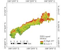
Fig.1
Overview of the study area"

Table 1
The information of remote sensing data"
| 序号 Number | 数据源 Data sources | 日期 Date | 分辨率 Resolution/m | 云量 Cloud (%) | 序号 Number | 数据源 Data sources | 日期 Date | 分辨率 Resolution/m | 云量 Cloud (%) | |
| 1 | Landsat-8 | 2013?12 | 15/30 | 0 | 14 | Sentinel-2 | 2018?12 | 10/20 | 0 | |
| 2 | Landsat-8 | 2014?02 | 15/30 | 0 | 15 | Sentinel-2 | 2019?03 | 10/20 | 40 | |
| 3 | Landsat-8 | 2014?06 | 15/30 | 40 | 16 | Sentinel-2 | 2019?09 | 10/20 | 0 | |
| 4 | Landsat-8 | 2015?04 | 15/30 | 0 | 17 | Landsat-8 | 2019?10 | 15/30 | 0 | |
| 5 | Landsat-8 | 2015?11 | 15/30 | 10 | 18 | Landsat-8 | 2019?12 | 15/30 | 0 | |
| 6 | Landsat-8 | 2016?06 | 15/30 | 10 | 19 | Sentinel-2 | 2020?02 | 10/20 | 2 | |
| 7 | Landsat-8 | 2016?10 | 15/30 | 0 | 20 | Landsat-8 | 2020?03 | 15/30 | 15 | |
| 8 | Landsat-8 | 2016?12 | 15/30 | 0 | 21 | Landsat-8 | 2020?05 | 15/30 | 0 | |
| 9 | Landsat-8 | 2017?03 | 15/30 | 0 | 22 | Sentinel-2 | 2020?10 | 10/20 | 0 | |
| 10 | Sentinel-2 | 2017?04 | 10/20 | 0 | 23 | Sentinel-2 | 2020?12 | 10/20 | 0 | |
| 11 | Landsat-8 | 2017?10 | 15/30 | 10 | 24 | Sentinel-2 | 2021?01 | 10/20 | 0 | |
| 12 | Landsat-8 | 2018?02 | 15/30 | 5 | 25 | Landsat-8 | 2021?10 | 15/30 | 10 | |
| 13 | Sentinel-2 | 2018?10 | 10/20 | 0 | 26 | Sentinel-2 | 2021?12 | 10/20 | 0 |
Fig.2
The model of simulating CCDC algorithm"
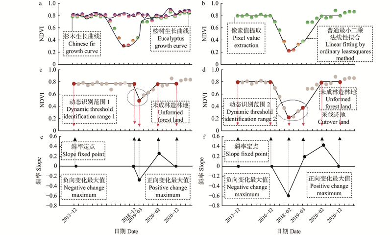
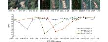
Fig.3
Time-series NDVI change analysis"
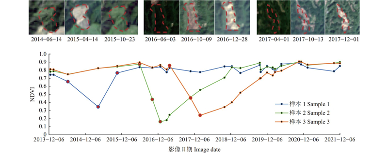
Fig.4
Classification and identification range division"
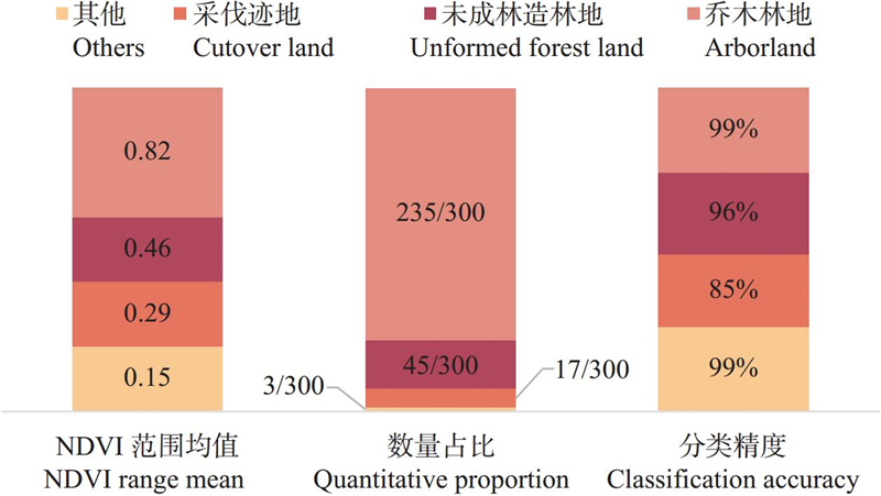
Fig.5
The detection situation of simulating CCDC"
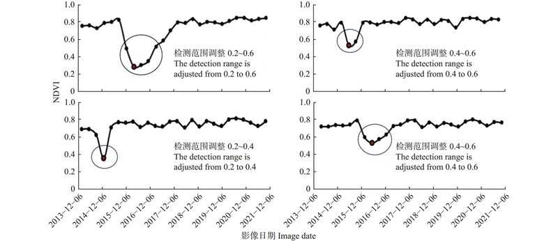
Table 2
The results of change detection"
| 检测算法 Detection algorithm | 样本数量 Number of samples | 准确率 Accuracy(%) |
| 基于PELT算法检测 Pruned exact linear Time | 100 | 35 |
| BS算法变点检测 Binary segmentation | 100 | 44 |
| 基于窗口的变点检测 Window-based detection | 100 | 66 |
| 改进的模拟CCDC Improved simulating CCDC | 100 | 82 |
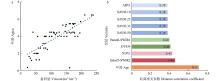
Fig.6
Correlation analysis"

Table 3
The results of volume estimation"
| 变量集 Variable set | 模型 Model | R2 | RMSE/ (m3 ·hm?2) | rRMSE (%) |
| 变量集1(波段值、植被指数和纹理特征) Set 1 (band values, vegetation index, and texture characteristics) | MLR | 0.16 | 48.73 | 41.12 |
| KNN | 0.32 | 43.83 | 37.23 | |
| RF | 0.34 | 43.10 | 35.35 | |
| SVR | 0.40 | 41.11 | 34.22 | |
| 变量集2(波段值、植被指数、纹理特征和年龄) Set 2 (band value, vegetation index, texture characteristics, and age) | MLR | 0.59 | 33.79 | 28.47 |
| KNN | 0.71 | 28.33 | 23.39 | |
| RF | 0.73 | 27.31 | 22.43 | |
| SVR | 0.83 | 22.08 | 18.15 |
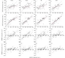
Fig.7
Scatter plots of model predicted values, residual values and stock volume"
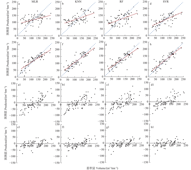
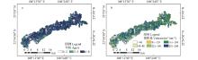
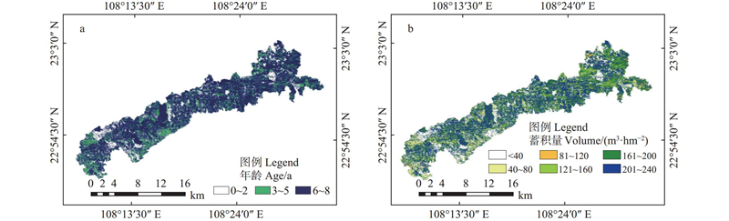
Fig.8
Spatial distribution of the age and volume in the study area"
|
曹 霖, 彭道黎, 王雪军, 等. 应用Sentinel-2A卫星光谱与纹理信息的森林蓄积量估算. 东北林业大学学报, 2018, 46 (9): 54- 58.
doi: 10.3969/j.issn.1000-5382.2018.09.012 |
|
|
Cao L, Peng D L, Wang X J, et al. Estimation of forest stock volume with spectral and textural information from the Sentinel-2A. Journal of Northeast Forestry University, 2018, 46 (9): 54- 58.
doi: 10.3969/j.issn.1000-5382.2018.09.012 |
|
|
黄秋霞, 蔡文华, 王嘉丽, 等. 基于时间序列的广西桉树人工林识别及时空变化分析. 中国科技论文, 2024, 19 (1): 123- 130.
doi: 10.3969/j.issn.2095-2783.2024.01.017 |
|
|
Huang Q X, Cai W H, Wang J L, et al. Identification and spatio-temporal variation analysis of eucalyptus plantations in Guangxi based on time series. Chinese Science and Technology Papers, 2024, 19 (1): 123- 130.
doi: 10.3969/j.issn.2095-2783.2024.01.017 |
|
| 李卯森. 基于时间序列卫星影像的广西桉树人工林林龄估测研究. 桂林: 桂林理工大学, 2022, (2): 78. | |
| Li M S. Research on the estimation of eucalyptus plantation ages in Guangxi based on time series satellite images. Guilin: Guilin University of Technology, 2022, (2): 78. | |
| 罗凯健, 许晓东, 龙江平, 等. 结合Landsat 8与PALSAR-2影像的龙南县针叶林蓄积量遥感估测研究. 林业资源管理, 2021, (1): 69- 76. | |
| Luo K J, Xu X D, Long J P, et al. Research on estimation of coniferous forest volume in Longnan County based on Landsat 8 and PALSAR-2 images. Forest Resources Management, 2021, (1): 69- 76. | |
|
齐元浩, 侯正阳, 刘太训, 等. 模型假设对基于模型的森林蓄积量估算的影响. 林业科学, 2024, 60 (9): 111- 123.
doi: 10.11707/j.1001-7488.LYKX20230041 |
|
|
Qi Y H, Hou Z Y, Liu T X, et al. The influence of model hypotheses on model-based forest stock volume estimation. Scientia Silvae Sinicae, 2024, 60 (9): 111- 123.
doi: 10.11707/j.1001-7488.LYKX20230041 |
|
|
沈文娟, 李明诗, 黄成全. 长时间序列多源遥感数据的森林干扰监测算法研究进展. 遥感学报, 2018, 22 (6): 1005- 1022.
doi: 10.11834/jrs.20187089 |
|
|
Shen W J, Li M S and Huang C Q. Research progress of forest disturbance monitoring algorithms using long-term multi-source remote sensing data. Journal of Remote Sensing, 2018, 22 (6): 1005- 1022.
doi: 10.11834/jrs.20187089 |
|
|
孙忠秋, 高金萍, 吴发云, 等. 基于机载激光雷达点云和随机森林算法的森林蓄积量估测. 林业科学, 2021, 57 (8): 68- 81.
doi: 10.11707/j.1001-7488.20210807 |
|
|
Sun Z Q, Gao J P, Wu F Y, et al. Estimating forest stock volume via small-footprint LiDAR point cloud data and random forest algorithm. Scientia Silvae Sinicae, 2021, 57 (8): 68- 81.
doi: 10.11707/j.1001-7488.20210807 |
|
|
吴 飏, 张登荣, 张汉奎, 等. 结合图像纹理特征的森林郁闭度遥感估测. 林业科学, 2012, 48 (2): 48- 53.
doi: 10.11707/j.1001-7488.20120207 |
|
|
Wu Y, Zhang D R, Zhang H K, et al. Remote sensing estimation of forest canopy closure combined with image texture features. Scientia Silvae Sinicae, 2012, 48 (2): 48- 53.
doi: 10.11707/j.1001-7488.20120207 |
|
|
向安民, 刘凤伶, 于宝义, 等. 基于k-NN方法和GF遥感影像的森林蓄积量估测. 浙江农林大学学报, 2017, 34 (3): 406- 412.
doi: 10.11833/j.issn.2095-0756.2017.03.004 |
|
|
Xiang A M, Liu F L, Yu B Y, et al. Forest stock volume estimation based on the k-NN method and GF remote sensing data. Journal of Zhejiang A & F University, 2017, 34 (3): 406- 412.
doi: 10.11833/j.issn.2095-0756.2017.03.004 |
|
| 徐期瑚, 林丽平, 薛春泉, 等. 基于树高-年龄分级的广东枫香生长模型. 林业资源管理, 2018, (5): 47- 53. | |
| Xu Q H, Lin L P, Xue C Q, et al. Height-age growth model for Liquidambar formosana in Guangdong using the classified height method. Forest Resources Management, 2018, (5): 47- 53. | |
| 杨 军. 2021. 卫星遥感技术在森林资源调查中的运用分析. 林业勘查设计, 50(2): 79−81. | |
| Yang J. 2020. Analysis on the application of satellite remote sensing technology in forest resources investigation. Forest Investigation Design, 50(2): 79−81. [in Chinese] | |
| 张立福, 王 飒, 刘华亮, 等. 从光谱到时谱——遥感时间序列变化检测研究进展. 武汉大学学报(信息科学版), 2021, 46 (4): 451- 468. | |
| Zhang L F, Wang S, Liu H L, et al. From spectrum to time spectrum - research progress on change detection of remote sensing time series. Journal of Wuhan University (Information Science Edition), 2021, 46 (4): 451- 468. | |
| 钟 莉, 陈芸芝, 汪小钦. 基于Landsat时序数据的森林干扰监测. 林业科学, 2020, 56 (5): 80- 88. | |
| Zhong L, Chen Y Z, Wang X Q. Forest disturbance monitoring based on Landsat time-series data. Scientia Silvae Sinicae, 2020, 56 (5): 80- 88. | |
|
周小成, 黄婷婷, 李 媛, 等. 结合遥感林龄因子的亚热带森林蓄积量估算方法. 林业科学, 2023, 59 (4): 88- 99.
doi: 10.11707/j.1001-7488.LYKX20210712 |
|
|
Zhou X C, Huang T T, Li Y, et al. Estimation method of subtropical forest stock volume combined with remote sensing forest age factors. Scientia Silvae Sinicae, 2023, 59 (4): 88- 99.
doi: 10.11707/j.1001-7488.LYKX20210712 |
|
|
周宇飞, 王振师, 钟映霞, 等. 基于无人机机载激光雷达的桉树蓄积量估测技术研究. 林业与环境科学, 2021, 37 (2): 7- 11.
doi: 10.3969/j.issn.1006-4427.2021.02.002 |
|
|
Zhou Y F, Wang Z S, Zhong Y X, et al. Research on the estimation technology of eucalyptus stock volume based on UAV airborne LiDAR. Forestry and Environmental Science, 2021, 37 (2): 7- 11.
doi: 10.3969/j.issn.1006-4427.2021.02.002 |
|
|
Dara A, Baumann M, Kuemmerle T, et al. Mapping the timing of cropland abandonment and recultivation in northern Kazakhstan using annual Landsat time series. Remote Sensing of Environment, 2018, 213, 49- 60.
doi: 10.1016/j.rse.2018.05.005 |
|
|
Deng R X, Xu Z R, Li Y, et al. Farmland Shelterbelt age mapping using Landsat time series images. Remote Sensing, 2022, 14 (6): 1457- 1457.
doi: 10.3390/rs14061457 |
|
|
Hu Y, Xu X L, Wu F, et al. Estimating forest stock volume in Hunan province, China, by integrating in situ plot data, Sentinel-2 images, and linear and machine learning regression models. Remote Sensing, 2020, 12 (1): 186- 186.
doi: 10.3390/rs12010186 |
|
| James C M, Txomin H, Michieal A W, et al. Estimating and mapping forest age across Canada’s forested ecosystems. Remote Sensing of Environment, 2023, 290, 4234- 4257. | |
|
Liu Z H, Ye Z L, Xu X D, et al. Mapping forest stock volume based on growth characteristics of crown using multi-temporal Landsat 8 OLI and ZY-3 stereo images in planted eucalyptus forest. Remote Sensing, 2022, 14 (20): 5082- 5082.
doi: 10.3390/rs14205082 |
|
| Marsden C, Maire G l, Stape J L, et al. Relating MODIS vegetation index time-series with structure, light absorption and stem production of fast-growing Eucalyptus plantations. Forest Ecology and Management, 2009, 259 (9): 1741- 1753. | |
|
Sergio M M, María-Teresa S F, Javier E, et al. Detecting abandoned citrus crops using Sentinel-2 time series. A case study in the Comunitat Valenciana region (Spain). ISPRS Journal of Photogrammetry and Remote Sensing, 2023, 201, 54- 66.
doi: 10.1016/j.isprsjprs.2023.05.003 |
|
| Wang M Y, Zheng Y, Huang C Q, et al. Assessing Landsat-8 and Sentinel-2 spectral-temporal features for mapping tree species of northern plantation forests in Heilongjiang Province, China. Forest Ecosystems, 2022, 9 (03): 344- 356. | |
| Zhang C C, Xiao X M, Zhao L C, et al. Mapping eucalyptus plantation in Guangxi, China by using knowledge-based algorithms and PALSAR-2, Sentinel-2, and Landsat images in 2020. International Journal of Applied Earth Observation and Geoinformation, 2023, 120, 1569- 8432. | |
|
Zhe Z. Change detection using Landsat time series: A review of frequencies, preprocessing, algorithms, and applications. ISPRS Journal of Photogrammetry and Remote Sensing, 2017, 130, 370- 384.
doi: 10.1016/j.isprsjprs.2017.06.013 |
|
|
Zhe Z, Woodcock C E. Continuous change detection and classification of land cover using all available Landsat data. Remote Sensing of Environment, 2014, 144, 152- 171.
doi: 10.1016/j.rse.2014.01.011 |
| [1] | Xu Wang,Hao Guo, Baoyinmanda,Guangyi Zhou,Yuehua Chen,Dangren Li. Damaged Characteristics and Influencing Factors of Cunninghamia lanceolata Mixed Plantations in Subtropics under Extreme Drought Conditions [J]. Scientia Silvae Sinicae, 2025, 61(5): 12-22. |
| [2] | Yingjie Sun,Denan Zhang,Yuyi Shen,Guangping Xu,Yang Cao,Kechao Huang,Yunshuang Chen,Xinyue Mao,Qiumei Teng,Shihong Lü,Junzhi Chu. Effects of Simulated Nitrogen Deposition on Soil Microbial Community Structure and Enzyme Activities in Eucalyptus Plantations in Mid-subtropical Region [J]. Scientia Silvae Sinicae, 2025, 61(5): 46-60. |
| [3] | Yafei Wang,Yang Liu,Kai Wang,Xiaofei Ding,Kexin Xu,Liming Jia,Benye Xi. Effects of Water-nitrogen Coupling Treatment on Growth of Populus tomentosa Pulp Forest and the Soil Moisture-nutrient Characteristics [J]. Scientia Silvae Sinicae, 2025, 61(5): 85-97. |
| [4] | Zhu Hongge, Zhao Menghan, Zhang Shaopeng. Impact and Mechanism of the Transformation of State-Owned Forest Management System on the Development of New Forestry Productivity [J]. Scientia Silvae Sinicae, 2025, 61(5): 207-221. |
| [5] | Feifei Yang,Wangfei Zhang,Lei Zhao,Han Zhao,Yongjie Ji,Mengjin Wang. Two-Stage Remote Sensing Feature Optimization and GF-1 Data-Supported Forest Above-Ground Biomass Inversion [J]. Scientia Silvae Sinicae, 2025, 61(4): 9-19. |
| [6] | Guangsheng Chen,Linzhi Wen,Wenjun Zhang,Chao Li,Ming Yu,Weipeng Jing. A Cross-Domain Generalization Classification Model for Tree Species in Complex Scenes Based on Feature Fusion [J]. Scientia Silvae Sinicae, 2025, 61(4): 33-45. |
| [7] | Gentana Ge,Lianggaoke Yue,Xiaosong Li,Cuicui Ji,Jianhe Wang,Tong Shen,Tiancan Wang. Estimation of Tree Height in the Grain for Green Program Stands of Inner Mongolia Based on GEDI and Sentinel-2 [J]. Scientia Silvae Sinicae, 2025, 61(3): 16-26. |
| [8] | Ziyan Tang,Jiming Liu,Xiaolong Huang,Jingzhong Chen,Deng Wang,Lixia Li,Huan Liu,Gelin Liang,Li Dai. Physiological Dynamic Changes during the Seed Germination Process of Cinnamomum migao [J]. Scientia Silvae Sinicae, 2025, 61(3): 135-146. |
| [9] | Lei Zhang,Xinglu Zhou,Lijuan Wang,Jianjun Hu. Advance of Poplar Molecular Breeding with Insect Resistance and Transgenic Biosafety Assessment Research [J]. Scientia Silvae Sinicae, 2025, 61(2): 190-203. |
| [10] | Xiaoyan Zhang,Xiaofeng Ni,Qiong Cai,Chengjun Ji. Leaf Anatomical Traits of Understory Plants and Their Response to Nitrogen Addition in a Chronosequence of Larix principis-rupprechtii Plantations in Saihanba, Hebei Province [J]. Scientia Silvae Sinicae, 2025, 61(1): 37-46. |
| [11] | Cong Zhang,Qi Liu,Haikui Li,Pengju Liu,Siying Zhan. Scale-Compatible and Tree Species-Classified Forest Carbon Storage Model of Volume-Derived in China [J]. Scientia Silvae Sinicae, 2025, 61(1): 57-69. |
| [12] | Kaida Yan,Fengjun Zhao,Liqing Si,Lifu Shu,Mingyu Wang,Weike Li,Dong Han,Xiaoxiao Li,Nuanyang Zhou. Research Progress on Forest Firebreaks and Firebreak Systems [J]. Scientia Silvae Sinicae, 2025, 61(1): 197-208. |
| [13] | Jingwei Tan,Huaiqing Zhang,Yang Liu,Jie Yang,Dongping Zheng. Question-answering Forestry Pre-trained Language Model: ForestBERT [J]. Scientia Silvae Sinicae, 2024, 60(9): 99-110. |
| [14] | Wanying Xie,Wenping Liu,Han Wang. UAV Images of Pine Forests for Early Detection of Pine Wood Nematode Infestation [J]. Scientia Silvae Sinicae, 2024, 60(9): 124-133. |
| [15] | Zhihan Yu,Hongqiang Yang. Research Frontier and Prospect of Forest Management Decision-Making Methodology Based on Generalized Faustmann Model [J]. Scientia Silvae Sinicae, 2024, 60(9): 170-182. |
| Viewed | ||||||
|
Full text |
|
|||||
|
Abstract |
|
|||||