
Scientia Silvae Sinicae ›› 2022, Vol. 58 ›› Issue (10): 47-58.doi: 10.11707/j.1001-7488.20221005
• Special Issue: Forest Fire Prevention Relevant Resource Monitoring, Analysis and Management Techniques in Zhangjiakou Competition Area of the Beijing Olympic Winter Games • Previous Articles Next Articles
Jia Li1,Lan Lan2,Zuozhong Zhang1,Wentao Yuan1,Demin Gao1,*,Shuqin Zong3,Qiaolin Ye1
Received:2021-11-26
Online:2022-10-25
Published:2023-04-23
Contact:
Demin Gao
CLC Number:
Jia Li,Lan Lan,Zuozhong Zhang,Wentao Yuan,Demin Gao,Shuqin Zong,Qiaolin Ye. Inversion Technology of Forest Fuel Moisture Content Based on Deep Learning[J]. Scientia Silvae Sinicae, 2022, 58(10): 47-58.
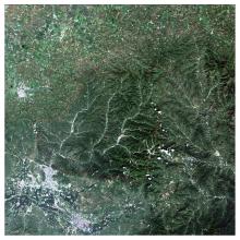
Fig.1
True-color remote sensing image in the study area"

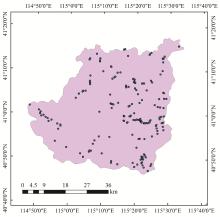
Fig.2
Distribution of quadrat points in the study area"

Table 1
Moisture index of various index types"
| 水分指数 Water index | 光谱指数 Spectral indices | 计算公式 Formula |
| 比值水分指数 Specific moisture index | 简单比 Simple ratio,SR | |
| 比值水分指数 Specific moisture index | 水分指数 Water index, WI | |
| 比值水分指数 Specific moisture index | 水分胁迫指数 Water stress index, WSI | |
| 比值水分指数 Specific moisture index | 简单水分指数 Simple ratio of water index,SRWI | |
| 归一化水分指数 Normalized water index | 归一化植被指数 Normalized difference vegetation index,NDVI | |
| 归一化水分指数 Normalized water index | 归一化差异水分指数 Normalized difference water index,NDWI | |
| 归一化水分指数 Normalized water index | 归一化红外指数 Normalized difference infrared index,NDII | |
| 复比值型指数 Complex ratio index | WI/NDVI |
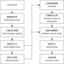
Fig.3
Inversion structure of moisture content of combustibles"


Fig.4
Structure diagram of deep learning MLP model"
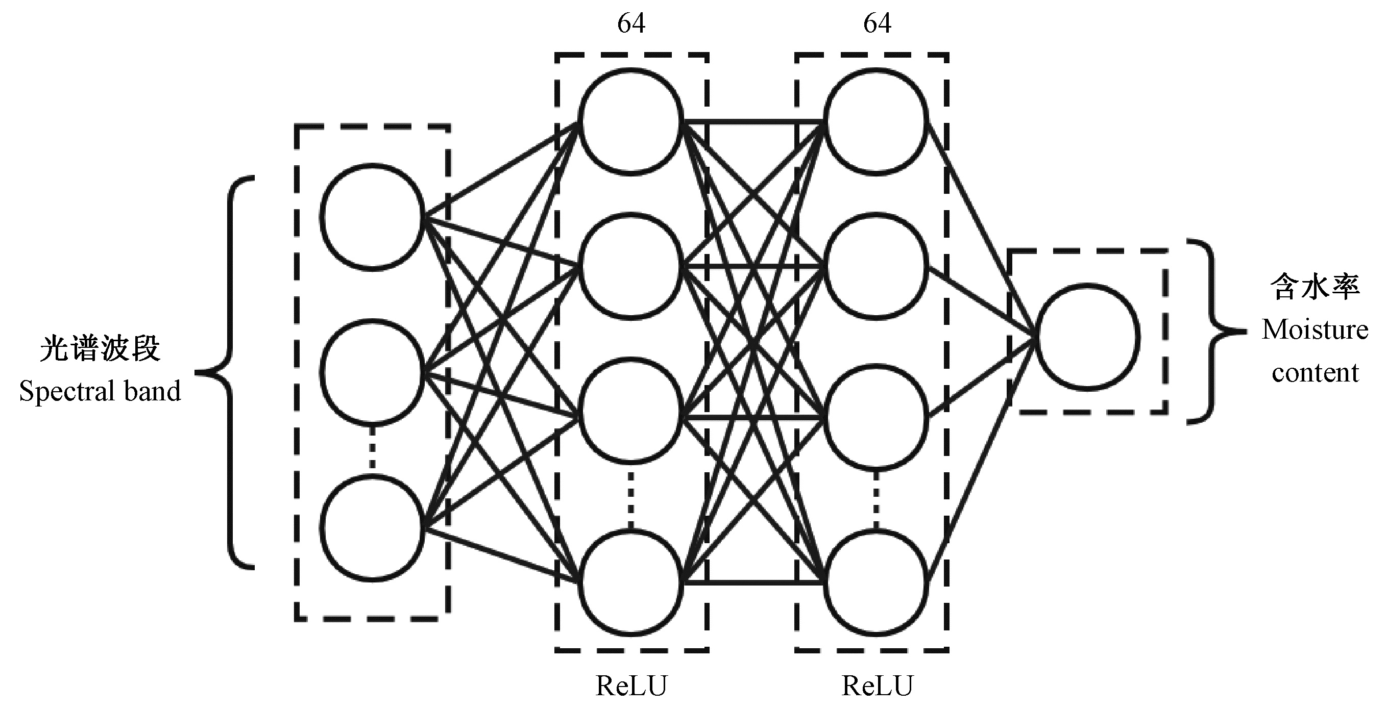
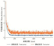
Fig.5
Comparison between training error and actual error in MLP model"
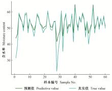
Fig.6
Comparison between predicted value and real value of MLP model"

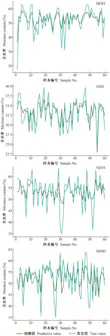
Fig.7
Comparison between predicted and actual values of canopy combustible moisture content based on SVR model"
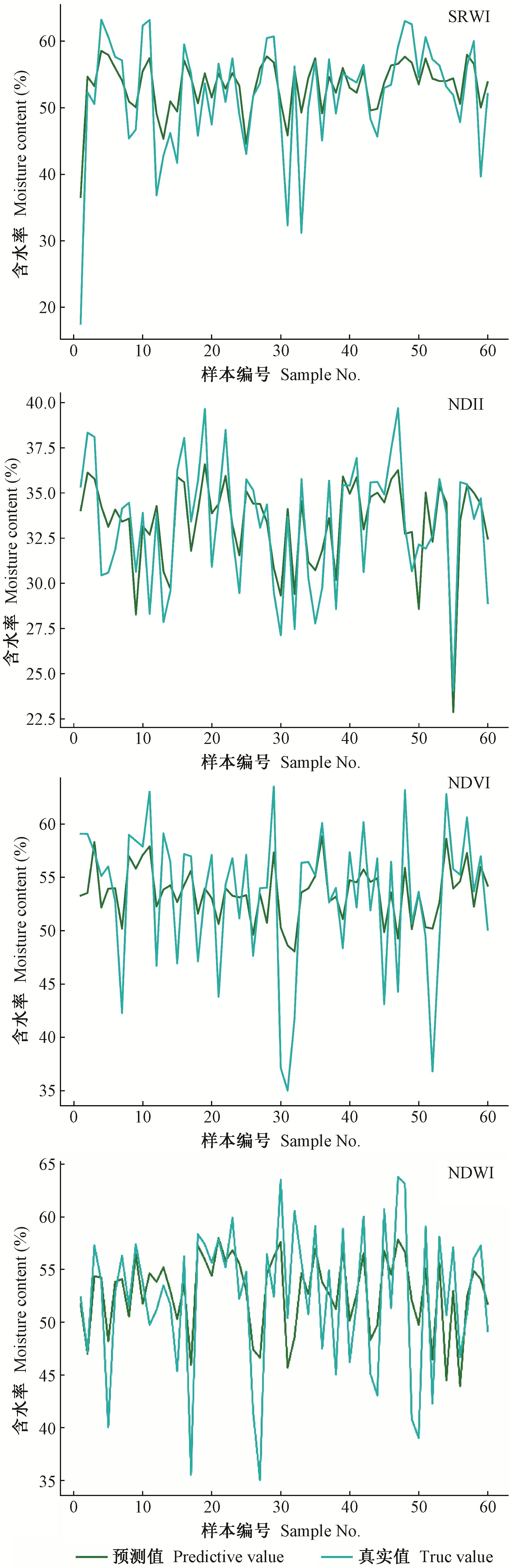
Table 2
Fitting degree of combustible moisture content of different models"
| 自变量 Independent variables | 拟合模型 Fitting model | 拟合度 Degree of fitting(R2) |
| 原始波段Original band | MLP | 0.843 |
| SRWI | SVR | 0.644 |
| NDII | SVR | 0.807 |
| NDVI | SVR | 0.703 |
| NDWI | SVR | 0.678 |
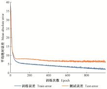
Fig.8
Comparison between training error and actual error in MLP model"
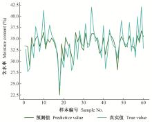
Fig.9
Comparison between predicted value and real value of MLP model"
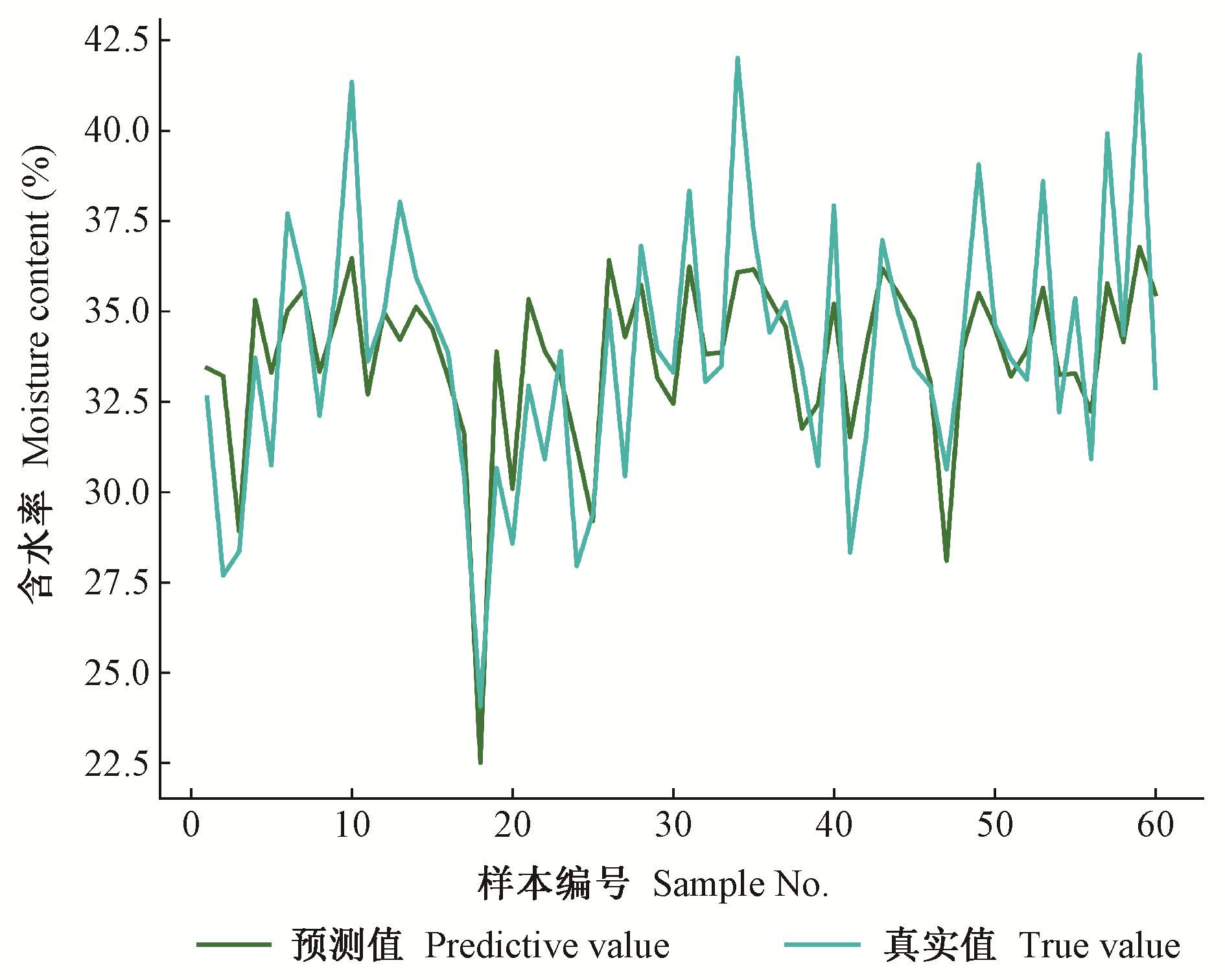
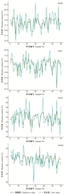
Fig.10
Comparison between predicted value and actual value of surface litter moisture content based on SVR model"
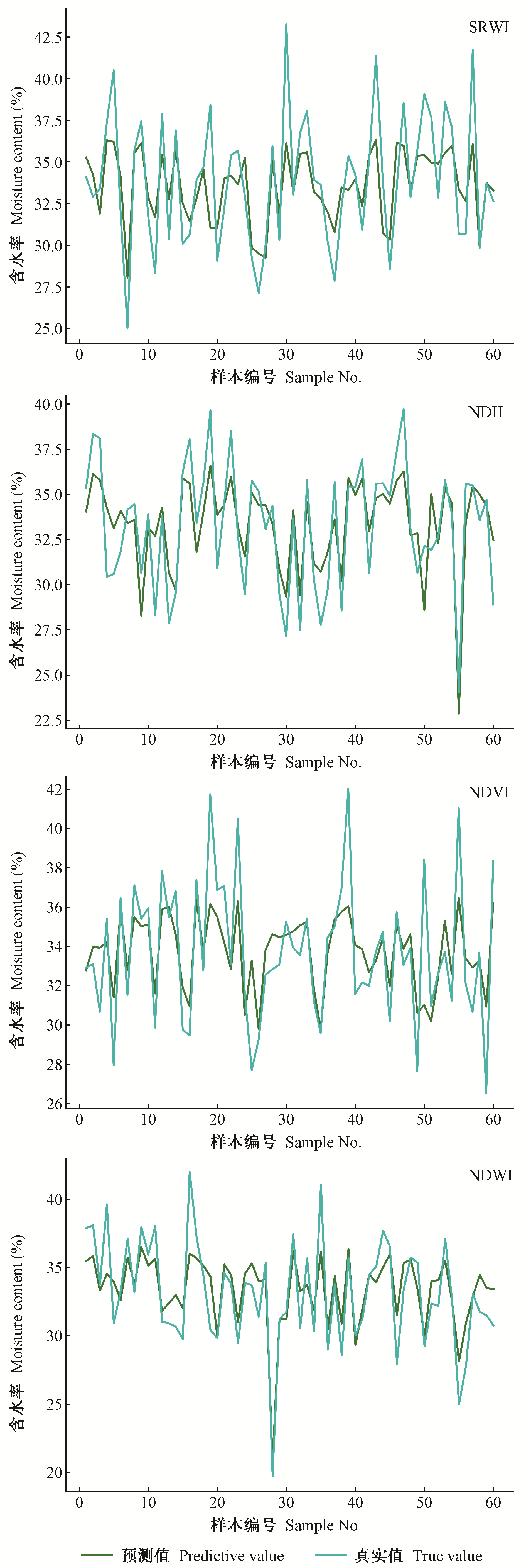
Table 3
Fitting degree of combustible moisture content of different models"
| 自变量 Independent variables | 拟合模型 Fitting model | 拟合度 Degree of fitting(R2) |
| 原始波段Original band | MLP | 0.448 |
| SR | SVR | 0.367 |
| NDII | SVR | 0.360 |
| NDVI | SVR | 0.408 |
| NDWI | SVR | 0.361 |
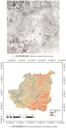
Fig.11
Inversion effect of moisture content of canopy combustibles in Chongli"
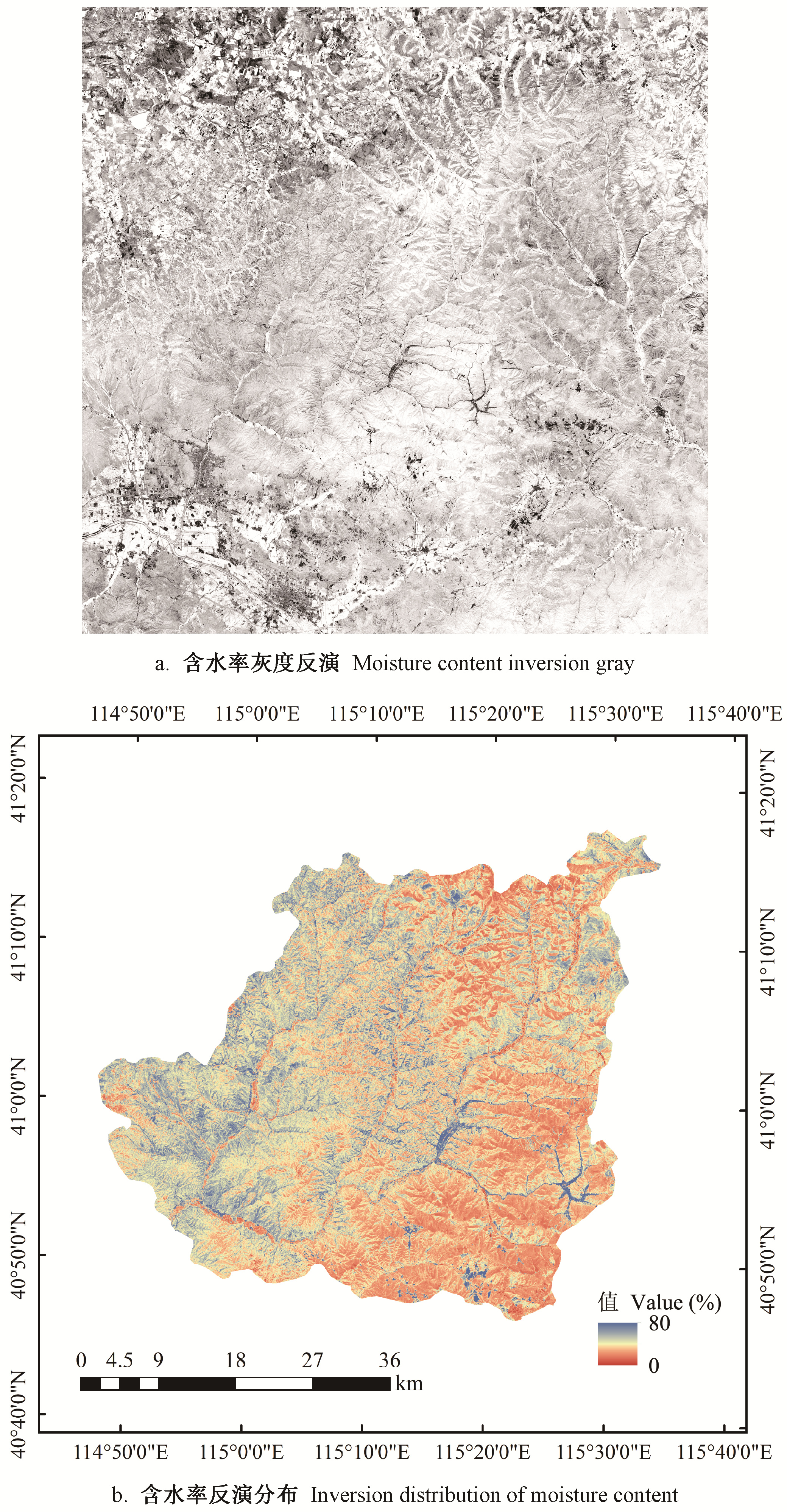
Fig.12
Inversion effect of surface litter moisture content in Chongli"

| 高超, 林红蕾, 胡海清, 等. 我国林火发生预测模型研究进展. 应用生态学报, 2020, 31 (9): 3227- 3240. | |
| Gao G , Lin H L , Hu H Q , et al. Research progress of forest fire prediction model in China. Journal of Applied Ecology, 2020, 31 (9): 3227- 3240. | |
| 耿冰, 孙义博, 曾巧林, 等. 基于深度学习方法的PM_(2.5)精细化时空估算模型. 中国环境科学, 2021, 41 (8): 3502- 3510. | |
| Geng B , Sun Y B , Zeng Q L , et al. PM based on deep learning method_(2.5) refined spatiotemporal estimation model. China Environmental Science, 2021, 41 (8): 3502- 3510. | |
| 郭建军, 张晓峰, 纪月, 等. 崇礼区域生态环境综合评价. 防护林科技, 2021, (1): 10- 12.10-12, 15 | |
| Guo J J , Zhang X F , Ji Y , et al. Comprehensive evaluation of ecological environment in Chongli region. Shelter forest science and technology, 2021, (1): 10- 12.10-12, 15 | |
| 郭新彬, 郑文霞, 曾爱聪, 等. 美国林火管理概况及分析. 应用生态学报, 2019, 30 (12): 4361- 4368. | |
| Guo X B , Zheng W X , Zeng A C , et al. Forest fire management in the United States. Chinese Journal of Applied Ecology, 2019, 30 (12): 4361- 4368. | |
| 刘曦, 金森. 平衡含水率法预测死可燃物含水率的研究进展. 林业科学, 2007, 43 (12): 126- 133. | |
| Liu X , Jin S . research progress in predicting moisture content of dead combustibles by equilibrium moisture content method. Forestry Science, 2007, 43 (12): 126- 133. | |
| 刘昕, 邸雪颖. 三种方法对森林地表可燃物含水率的预测评价. 森林工程, 2013, 29 (2): 8- 13.8-13, 20 | |
| Liu X , Di X Y . Prediction and evaluation of moisture content of forest surface combustibles by three methods. Forest engineering, 2013, 29 (2): 8- 13.8-13, 20 | |
| 吕杰. 2012. 基于机器学习和辐射传输模型的农作物叶绿素含量高光谱反演模型. 北京: 中国地质大学(北京). | |
| Lü J. 2012. Hyperspectral inversion model of crop chlorophyll content based on machine learning and radiative transfer model. Beijing: China University of Geosciences(Beijing). [in Chinese] | |
| 潘佩芬, 杨武年, 简季, 等. 基于光谱指数的植被含水率遥感反演模型研究——以岷江上游毛尔盖地区为例. 遥感信息, 2013, 28 (3): 69- 73. | |
| Pan P F , Yang W N , Jian J , et al. Study on remote sensing inversion model of vegetation moisture content based on spectral index—Taking Maoergai area in the upper reaches of Minjiang River as an example. Remote Sensing Information, 2013, 28 (3): 69- 73. | |
| 申洪源, 马亮, 张雅楠, 等. 基于多传感器和SVR算法的油田多相流实时计量技术研究. 仪器仪表用户, 2019, 26 (10): 15- 19. | |
| Shen H Y , Ma L , Zhang Y N , et al. Research on real-time measurement technology of oilfield multiphase flow based on multisensor and SVR algorithm. Instrument Users, 2019, 26 (10): 15- 19. | |
| 王熊. 2020. 基于哨兵二号的森林动态变化检测方法研究. 武汉: 华中农业大学. | |
| Wang X. 2020. Study on forest dynamic change detection method based on sentry 2. Wuhan: Huazhong Agricultural University. [in Chinese] | |
| 谢字希. 2016. 黑龙江大兴安岭地区森林枯落物含水率遥感反演. 哈尔滨: 东北林业大学. | |
| Xie Z X. 2016. Remote sensing inversion of forest litter moisture content in Daxing'anling area, Heilongjiang Province. Harbin: Northeast Forestry University. [in Chinese] | |
| 谢字希, 胡海清, 杨曦光, 等. 基于实测光谱的大兴安岭地区典型森林枯落物含水率估测模型. 生态学杂志, 2017, 36 (11): 3321- 3328. | |
| Xie Z X , Hu H Q , Yang X G , et al. Estimation model of water content of typical forest litter in Daxing'anling area based on measured spectrum. Journal of Ecology, 2017, 36 (11): 3321- 3328. | |
| 张佳华, 许云, 姚凤梅, 等. 植被含水量光学遥感估算方法研究进展. 中国科学: 技术科学, 2010, 40 (10): 1121- 1129. | |
| Zhang J H , Xu Y , Yao F M , et al. Research progress on optical remote sensing estimation method of vegetation water content. Chinese Science: Technical Science, 2010, 40 (10): 1121- 1129. | |
| 张恒, 刘鑫源, 李星汉, 等. 我国气象要素回归法预测地表可燃物含水率研究进展. 森林防火, 2018, (3): 25- 31. | |
| Zhang H , Liu X Y , Li X H , et al. Research progress on prediction of surface combustible moisture content by meteorological factor regression method in China. Forest Fire Prevention, 2018, (3): 25- 31. | |
| 赵美霞. 2021. 北京2022年冬奥会背景下河北省冰雪运动政策研究. 北京: 首都体育学院. | |
| Zhao M X. 2021. Research on ice and snow sports policy of Hebei Province under the background of Beijing 2022 Winter Olympic Games. Beijing: Capital Institute of Physical Education. [in Chinese] | |
| 赵永光, 马灵玲, 李传荣, 等. 基于冠层辐射传输模型的地表反射率光谱重建方法. 光谱学与光谱分析, 2015, 35 (7): 1763- 1769. | |
| Zhao Y G , Ma L L , Li C R , et al. Spectral reconstruction method of surface reflectance based on canopy radiative transfer model. Spectroscopy and Spectral Analysis, 2015, 35 (7): 1763- 1769. | |
| Barmpoutis P , Papaioannou P , Dimitropoulos K , et al. A review on early forest fire detection systems using optical remote sensing. Sensors, 2020, 20 (22) | |
| Maffei C , Lindenbergh R , Menenti M . Combining multi-spectral and thermal remote sensing to predict forest fire characteristics. ISPRS Journal of Photogrammetry and Remote Sensing, 2021, 181, 400- 412. | |
| Mohajane M , Costache R , Karimi F , et al. Application of remote sensing and machine learning algorithms for forest fire mapping in a Mediterranean area. Ecological Indicators, 2021, 129, 107869. | |
| Moritz M A , Batllori E , Bradstock R A . Learning to coexist with wildfire. Nature, 2014, 515, 58- 66. | |
| Pisek J , Erb A , Korhonen L , et al. Retrieval and validation of forest background reflectivity from daily Moderate Resolution Imaging Spectroradiometer(MODIS) bidirectional reflectance distribution function(BRDF) data across European forests. Biogeosciences, 2021, 18 (2): 621- 635. | |
| Quan X , Yebra M , Riaño D , et al. Global fuel moisture content mapping from MODIS. International Journal of Applied Earth Observations and Geoinformation, 2021, 101, 102354. | |
| Schneider F D , l Kükenbrink D , Schaepman M E , et al. Quantifying 3D structure and occlusion in dense tropical and temperate forests using close-range LiDAR. Agricultural and Forest Meteorology, 2019, 268 | |
| Ye Q , Huang P , Zhang Z , et al. Multiview learning with robust double-sided twin SVM. IEEE Transactions on Cybernetics, 2021, |
| [1] | Ying Pan,Mingming Ding,Jie Lin,Qiao Dai,Geng Guo,Linlin Cui. Inversion of Forest Leaf Area Index Based on PROSAIL Model and Multi-Angle Remote Sensing Data [J]. Scientia Silvae Sinicae, 2021, 57(4): 90-106. |
| [2] | Yan Zhou,Wenping Liu,Youqing Luo,Shixiang Zong. Small Object Detection for Infected Trees Based on the Deep Learning Method [J]. Scientia Silvae Sinicae, 2021, 57(3): 98-107. |
| [3] | Ying Guo,Zengyuan Li,Erxue Chen,Xu Zhang,Lei Zhao,Yan Chen,Yahui Wang. A Deep Learning Method for Forest Fine Classification Based on High Resolution Remote Sensing Images: Two-Branch FCN-8s [J]. Scientia Silvae Sinicae, 2020, 56(3): 48-60. |
| [4] | Mingwei Shao,Junyu Dong. A New Algorithm for Automatic Optimizing Cross-Cut Saw Based on Deep Learning Algorithm [J]. Scientia Silvae Sinicae, 2020, 56(12): 123-129. |
| [5] | Liu Luxia, Pang Yong, Ren Haibao, Li Zengyuan. Predict Tree Species Diversity from GF-2 Satellite Data in a Subtropical Forest of China [J]. Scientia Silvae Sinicae, 2019, 55(2): 61-74. |
| [6] | Qiu Ni, Xu Songjun, Qiu Penghua, Yang Wenhuai, Yang Xiu, Yang Qian. Community Distribution and Landscape Pattern of the Mangrove on the Qi'ao Island, Zhuhai [J]. Scientia Silvae Sinicae, 2019, 55(1): 1-10. |
| [7] | Li Xiaohong, Chen Erxue, Li Zengyuan, Li Shiming. Object Based Land Cover Classification Method Integrating Multi-Source Remote Sensing Data [J]. Scientia Silvae Sinicae, 2018, 54(2): 68-80. |
| [8] | Zu Xiaofeng, Qin Xianlin, Li Zengyuan, Sun Guifen, Liu Shuchao. Method for Burned Forest Biomass Estimation Using Satellite Remote Sensing Based on Power Law Distribution [J]. Scientia Silvae Sinicae, 2017, 53(10): 90-99. |
| [9] | Zheng Wei;Li Yajun;Liu Cheng;Wang Meng. Extracting Forest Burned Scar Region Area Based on Multi-Source Remote Sensing Data [J]. Scientia Silvae Sinicae, 2011, 47(8): 192-195. |
| [10] | Tan Bingxiang;Du Jishan. Analysis of Vegetation and Soil Erosion for Forest Areas Using Remote Sensing Data [J]. Scientia Silvae Sinicae, 2006, 42(4): 7-11. |
| Viewed | ||||||
|
Full text |
|
|||||
|
Abstract |
|
|||||