
Scientia Silvae Sinicae ›› 2020, Vol. 56 ›› Issue (3): 48-60.doi: 10.11707/j.1001-7488.20200306
• Articles • Previous Articles Next Articles
Ying Guo,Zengyuan Li,Erxue Chen*,Xu Zhang,Lei Zhao,Yan Chen,Yahui Wang
Received:2019-07-12
Online:2020-03-25
Published:2020-04-08
Contact:
Erxue Chen
CLC Number:
Ying Guo,Zengyuan Li,Erxue Chen,Xu Zhang,Lei Zhao,Yan Chen,Yahui Wang. A Deep Learning Method for Forest Fine Classification Based on High Resolution Remote Sensing Images: Two-Branch FCN-8s[J]. Scientia Silvae Sinicae, 2020, 56(3): 48-60.

Fig.1
Preprocessed GF-2 image"
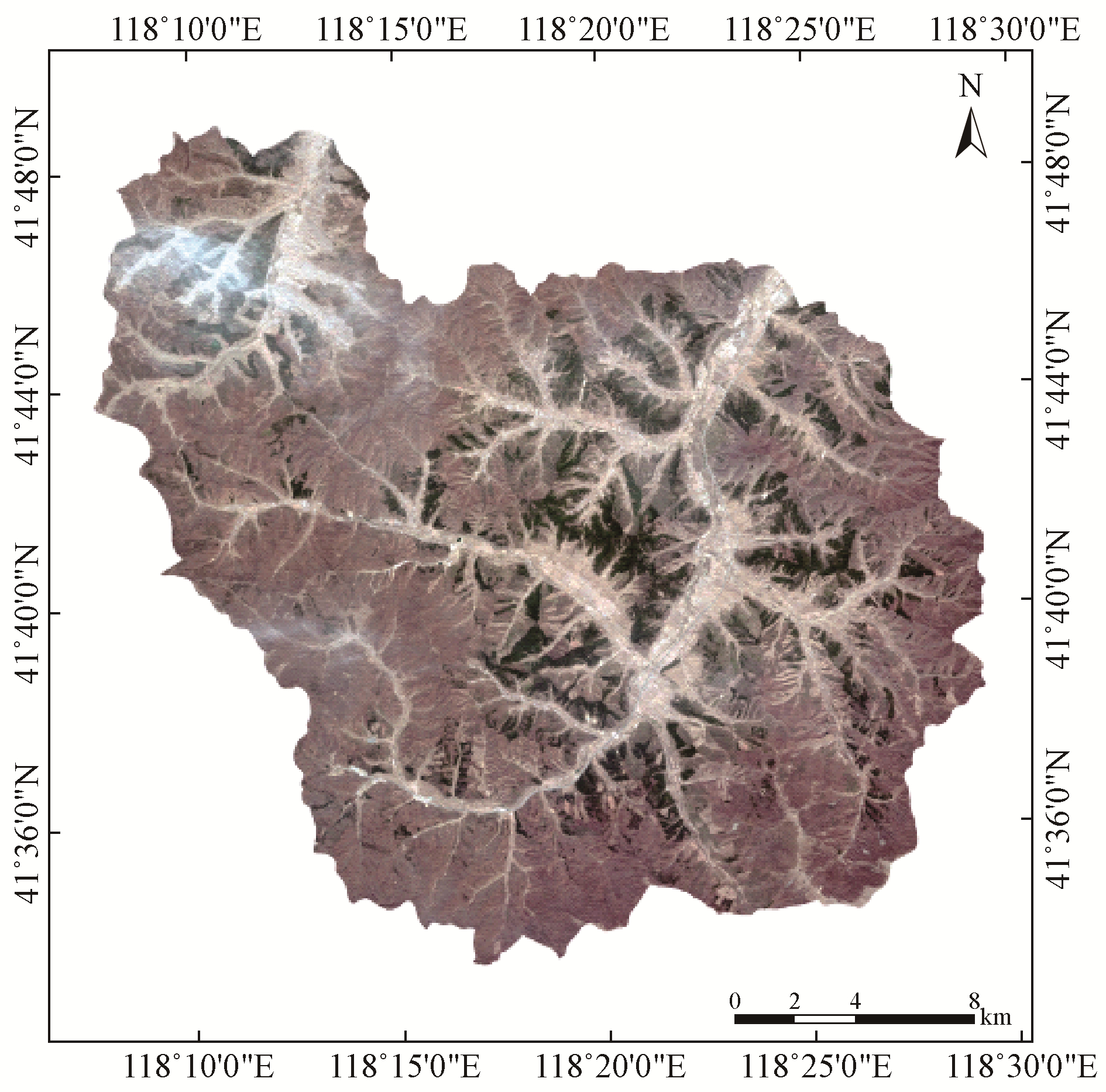
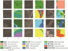
Fig.2
Examples in details for some of the training samples"
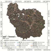
Fig.3
Spatial distribution of the field survey sample points and some of the training samples"
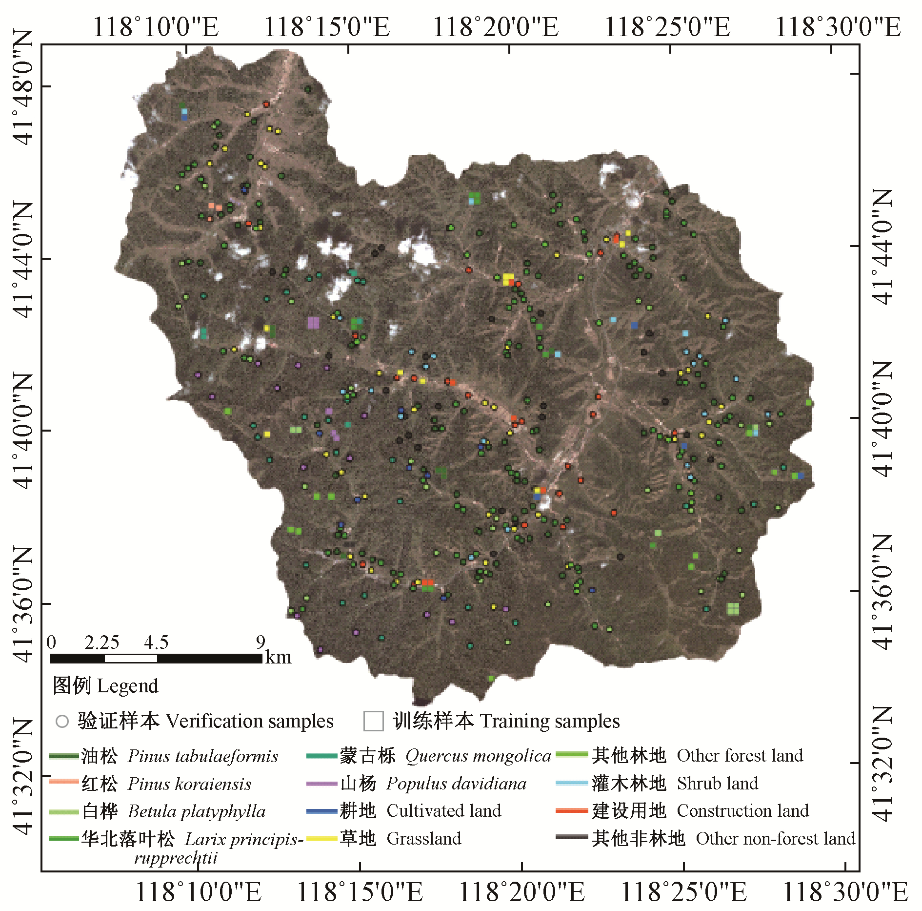
Table 1
Classification system of the study area"
| 一级 Class one | 二级 Class two | 三级 Class three |
| 林地Forest land | 有林地Woodland | 油松Pinus tabulaeformis |
| 华北落叶松Larix principis-rupprechtii | ||
| 红松Pinus koraiensis | ||
| 白桦Betula platyphylla | ||
| 山杨Populus davidiana | ||
| 蒙古栎Quercus mongolica | ||
| 非林地Non-forest land | 灌木林地Shrub land | / |
| 其他林地Other forest land | / | |
| 耕地Cultivated land | / | |
| 草地Grassland | / | |
| 建设用地Construction land | / | |
| 其他非林地Other non-forest land | / |

Fig.4
FCN model architecture"
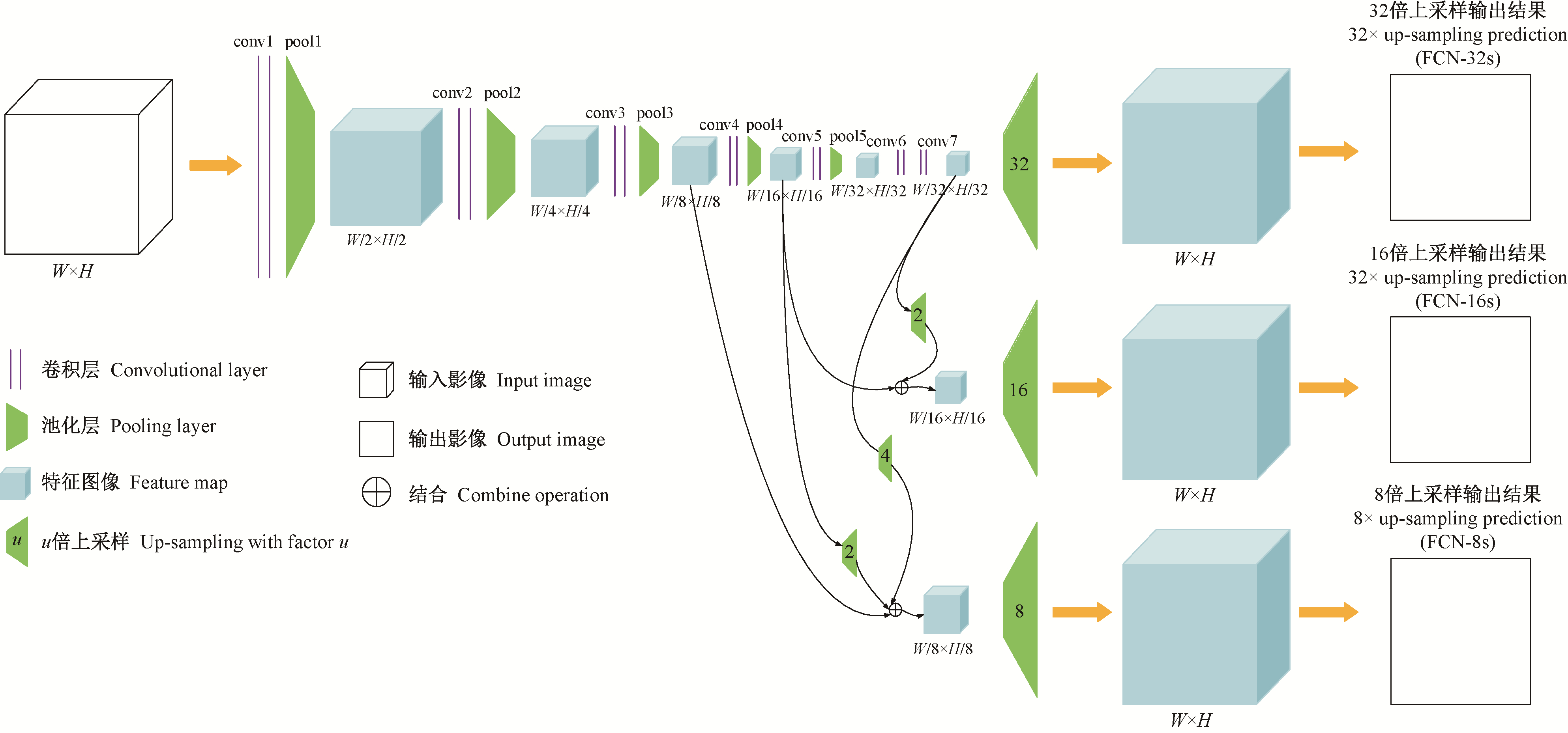

Fig.5
The general workflow of the two-branch FCN-8s classification method"
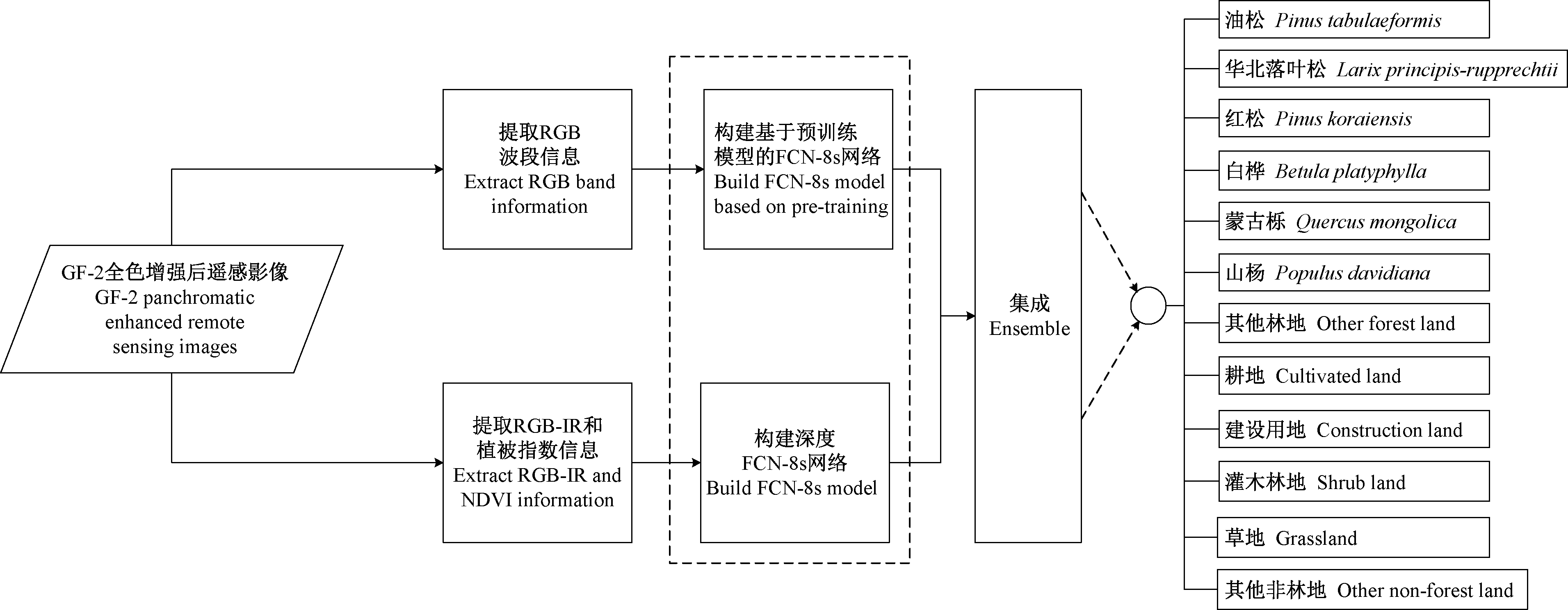

Fig.6
The data flow of the two-branch FCN-8s classification method"
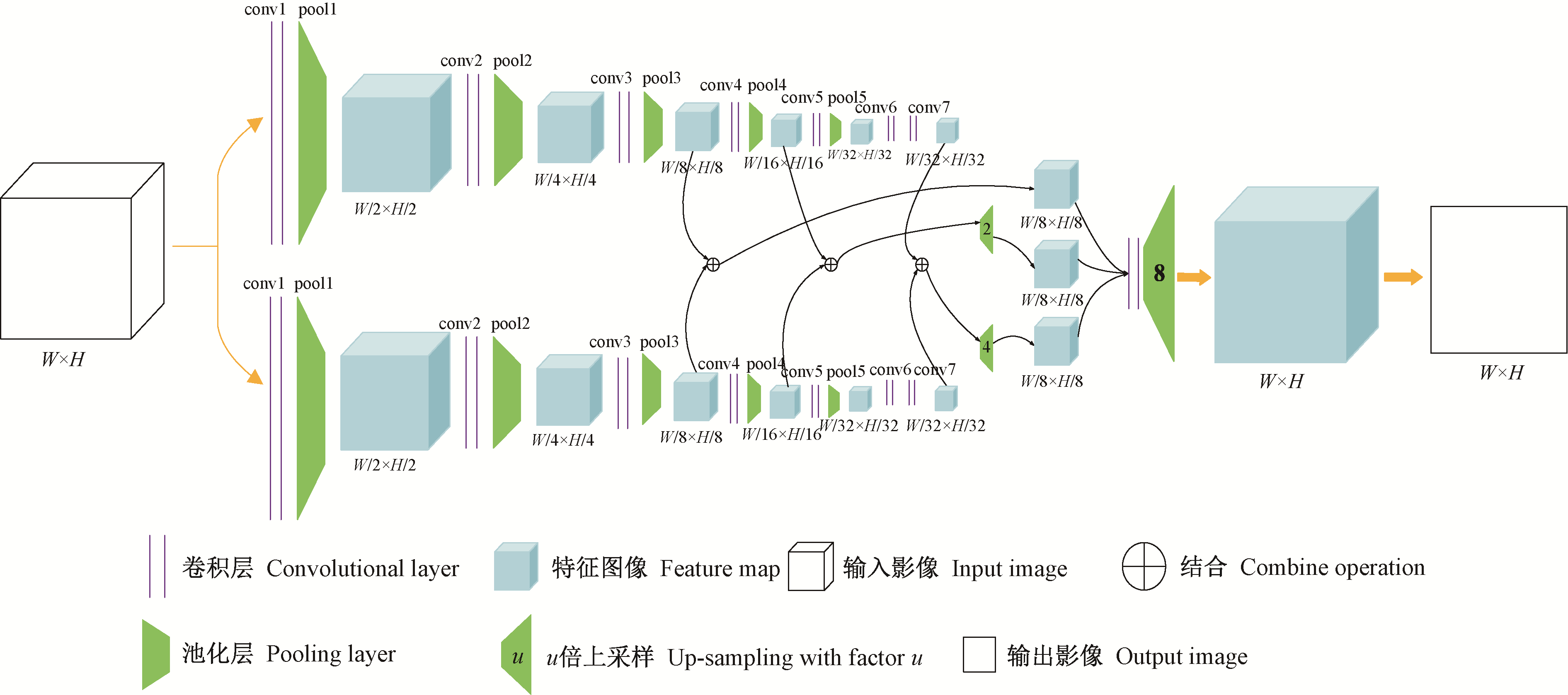
Table 2
Confusion matrix of classification result of two-branch FCN-8s"
| 油松 Pinus tabulaeformis | 华北落叶松 Larix principis-rupprechtii | 红松 Pinus koraiensis | 白桦 Betula platyphylla | 蒙古栎 Quercus mongolica | 山杨 Populus davidiana | 其他林地 Other forest land | 耕地 Cultivated land | 建设用地 Construction land | 灌木林地 Shrub land | 草地 Grassland | 其他非林地 Other non-forest land | 总计 Total | |
| 油松Pinus tabulaeformis | 70 | 2 | 0 | 4 | 0 | 3 | 1 | 0 | 0 | 0 | 0 | 0 | 80 |
| 华北落叶松 Larix principis-rupprechtii | 2 | 62 | 0 | 1 | 0 | 0 | 1 | 0 | 0 | 0 | 0 | 0 | 66 |
| 红松Pinus koraiensis | 0 | 0 | 15 | 0 | 0 | 1 | 0 | 0 | 0 | 0 | 0 | 0 | 16 |
| 白桦Betula platyphylla | 0 | 1 | 0 | 23 | 1 | 0 | 0 | 3 | 0 | 0 | 0 | 0 | 28 |
| 蒙古栎Quercus mongolica | 0 | 0 | 0 | 0 | 27 | 0 | 0 | 1 | 2 | 0 | 0 | 0 | 30 |
| 山杨Populus davidiana | 1 | 0 | 0 | 10 | 0 | 6 | 1 | 0 | 0 | 0 | 0 | 0 | 18 |
| 其他林地 Other forest land | 1 | 3 | 0 | 8 | 0 | 0 | 0 | 1 | 8 | 0 | 0 | 0 | 21 |
| 耕地Cultivated land | 0 | 1 | 0 | 0 | 0 | 0 | 1 | 34 | 0 | 2 | 1 | 0 | 39 |
| 建设用地Construction land | 0 | 0 | 0 | 0 | 0 | 0 | 0 | 0 | 40 | 0 | 0 | 1 | 40 |
| 灌木林地Shrub land | 0 | 0 | 0 | 0 | 0 | 0 | 2 | 2 | 0 | 21 | 0 | 0 | 25 |
| 草地Grassland | 0 | 0 | 0 | 0 | 0 | 0 | 0 | 0 | 0 | 0 | 11 | 0 | 11 |
| 其他非林地Other non-forest land | 0 | 0 | 0 | 0 | 0 | 0 | 0 | 0 | 0 | 0 | 0 | 30 | 30 |
| 总计Total | 74 | 69 | 15 | 46 | 28 | 15 | 16 | 36 | 40 | 23 | 12 | 30 | 404 |

Fig.7
Classification result of the two-branch FCN-8s method"
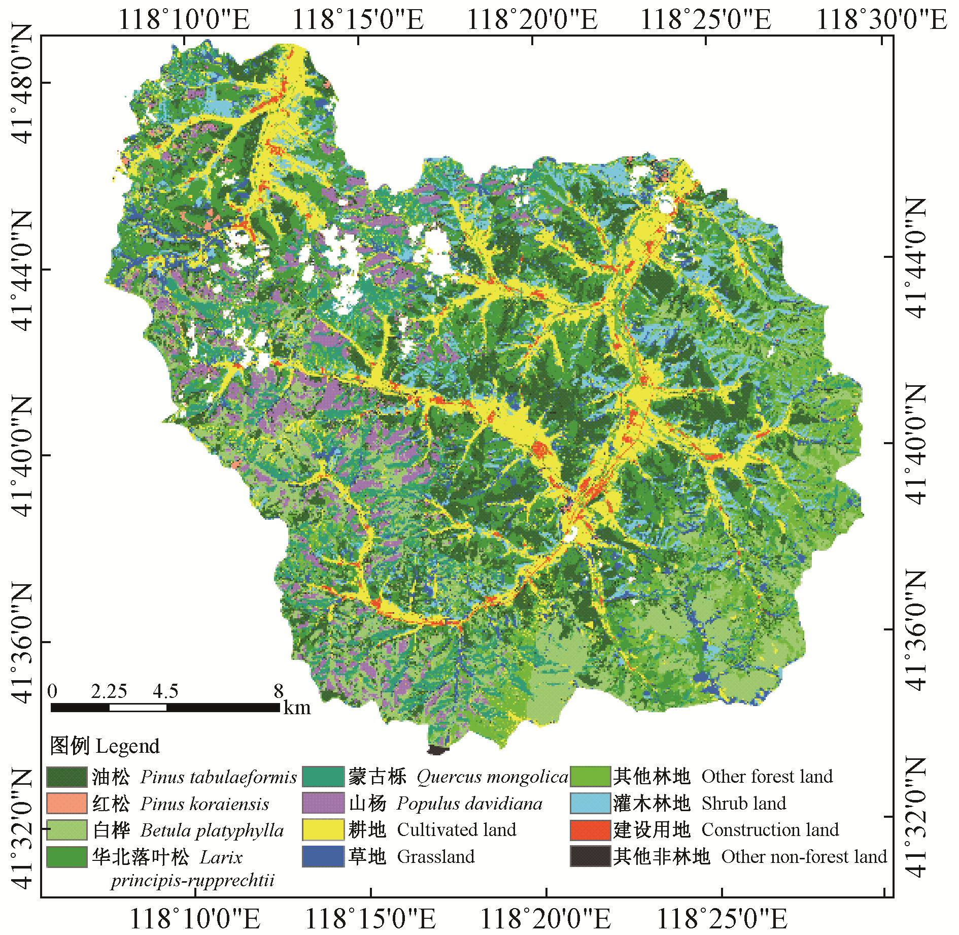
Table 3
Comparison of classification accuracy among two-branch FCN-8s, FCN-8s and SVM"
| 地类 Land cover type | 双支FCN-8s Two-branch FCN-8s | FCN-8s | SVM | |||||
| 生产者精度 Producer accuracy(%) | 用户精度 User accuracy(%) | 生产者精度 Producer accuracy(%) | 用户精度 User accuracy(%) | 生产者精度 Producer accuracy(%) | 用户精度 User accuracy(%) | |||
| 油松Pinus tabulaeformis | 94.59 | 87.50 | 90.54 | 82.72 | 79.73 | 81.94 | ||
| 华北落叶松Larix principis-rupprechtii | 89.86 | 93.94 | 94.20 | 87.84 | 88.41 | 70.93 | ||
| 红松Pinus koraiensis | 100.00 | 93.75 | 100.00 | 93.75 | 93.33 | 100.00 | ||
| 白桦Betula platyphylla | 50.00 | 82.14 | 26.09 | 80.00 | 56.52 | 68.42 | ||
| 蒙古栎Quercus mongolica | 96.43 | 90.00 | 100.00 | 82.35 | 96.43 | 79.41 | ||
| 山杨Populus davidiana | 40.00 | 33.33 | 40.00 | 26.09 | 66.67 | 43.48 | ||
| 其他林地Other forest land | 50.00 | 38.10 | 56.25 | 42.86 | 31.25 | 62.50 | ||
| 耕地Cultivated land | 94.44 | 87.18 | 97.22 | 87.50 | 97.22 | 56.45 | ||
| 建设用地Construction land | 100.00 | 100.00 | 100.00 | 100.00 | 97.50 | 97.50 | ||
| 灌木林地Shrub land | 91.30 | 80.77 | 86.96 | 95.24 | 21.74 | 100.00 | ||
| 草地Grassland | 91.67 | 100.00 | 75.00 | 100.00 | 50.00 | 100.00 | ||
| 其他非林地Other non-forest land | 100.00 | 90.91 | 93.33 | 93.33 | 53.33 | 100.00 | ||
| 总体精度Overall accuracy(%) | 85.89 | 82.67 | 75.00 | |||||
| Kappa系数Kappa coefficient | 0.841 4 | 0.805 0 | 0.716 8 | |||||
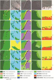
Fig.8
The detailed classification results"

Table 4
Impact of NDVI features and finetune strategy on classification accuracy of two-branch FCN-8s model"
| 地类 Land cover type | 双支FCN-8s Two-branch FCN-8s | 双支FCN-8s不使用微调策略 Two-branch FCN-8s without finetune strategy | 双支FCN-8s不加入NDVI特征 Two-branch FCN-8s without NDVI | |||||
| 生产者精度 Producer accuracy(%) | 用户精度 User accuracy(%) | 生产者精度 Producer accuracy(%) | 用户精度 User accuracy(%) | 生产者精度 Producer accuracy(%) | 用户精度 User accuracy(%) | |||
| 油松Pinus tabulaeformis | 94.59 | 87.50 | 82.43 | 88.41 | 86.49 | 84.21 | ||
| 华北落叶松Larix principis-rupprechtii | 89.86 | 93.94 | 89.86 | 82.67 | 89.86 | 87.32 | ||
| 红松Pinus koraiensis | 100.00 | 93.75 | 100.00 | 100.00 | 100.00 | 100.00 | ||
| 白桦Betula platyphylla | 50.00 | 82.14 | 36.96 | 73.91 | 56.52 | 70.27 | ||
| 蒙古栎Quercus mongolica | 96.43 | 90.00 | 92.86 | 74.29 | 96.43 | 90.00 | ||
| 山杨Populus davidiana | 40.00 | 33.33 | 46.67 | 36.84 | 26.67 | 30.77 | ||
| 其他林地Other forest land | 50.00 | 38.10 | 31.25 | 25.00 | 43.75 | 38.89 | ||
| 耕地Cultivated land | 94.44 | 87.18 | 91.67 | 78.57 | 97.22 | 70.00 | ||
| 建设用地Construction land | 100.00 | 100.00 | 95.00 | 100.00 | 82.50 | 100.00 | ||
| 灌木林地Shrub land | 91.30 | 80.77 | 82.61 | 76.00 | 91.30 | 95.45 | ||
| 草地Grassland | 91.67 | 100.00 | 75.00 | 81.82 | 66.67 | 100.00 | ||
| 其他非林地Other non-forest land | 100.00 | 90.91 | 96.67 | 90.63 | 96.67 | 93.55 | ||
| 总体精度Overall accuracy(%) | 85.89 | 79.46 | 81.93 | |||||
| Kappa系数Kappa coefficient | 0.841 4 | 0.769 3 | 0.796 3 | |||||
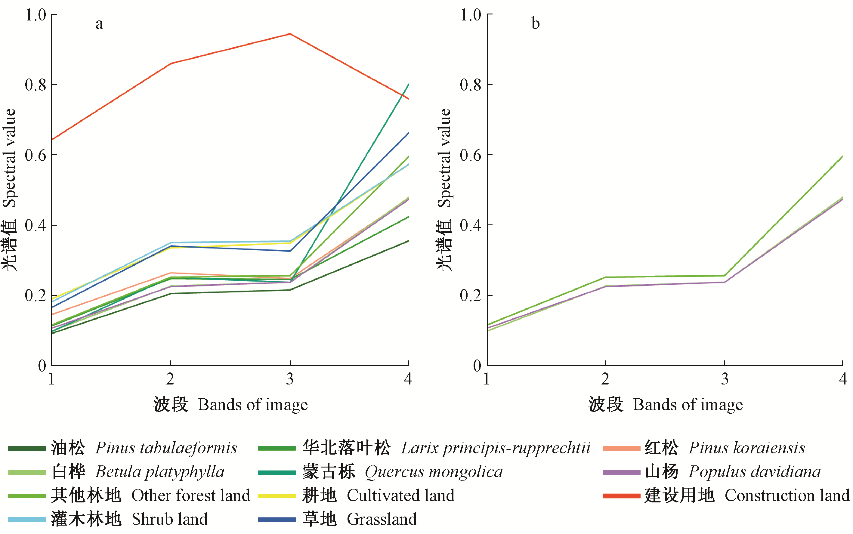
Fig.9
Spectral curves of land cover types"
|
陈广胜, 陈守玉, 景维鹏, 等. 基于遗传算法与全卷积网络的遥感影像像素级分类方法. 小型微型计算机系统, 2018. 39 (7): 1590- 1595.
doi: 10.3969/j.issn.1000-1220.2018.07.041 |
|
|
Chen G S , Chen S Y , Jing W P , et al. Remote sensing image pixel-level classification with genetic algorithm and fully convolutional network. Journal of Chinese Computer Systems, 2018. 39 (7): 1590- 1595.
doi: 10.3969/j.issn.1000-1220.2018.07.041 |
|
| 丁世飞, 齐丙娟, 谭红艳. 支持向量机理论与算法研究综述. 电子科技大学学报, 2011. 40 (1): 2- 10. | |
| Ding S F , Qi B J , Tan H Y . An overview on theory and algorithm of support vector machines. Journal of University of Electronic Science and Technology of China, 2011. 40 (1): 2- 10. | |
| 方旭, 王光辉, 杨化超, 等. 结合均值漂移分割与全卷积神经网络的高分辨遥感影像分类. 激光与光电子学进展, 2018. 55 (2): 446- 454. | |
| Fang X , Wang G H , Yang H C , et al. High resolution remote sensing image classification combining with mean-shift segmentation and fully convolution neural network. Laser & Optoelectronics Progress, 2018. 55 (2): 446- 454. | |
|
高永年, 张万昌. 遥感影像地形校正研究进展及其比较实验. 地理研究, 2008. 27 (02): 467- 478.
doi: 10.3321/j.issn:1000-0585.2008.02.024 |
|
|
Gao Y N , Zhang W C . Comparison test and research progress of topographic correction on remotely sensed data. Geographical Research, 2008. 27 (02): 467- 478.
doi: 10.3321/j.issn:1000-0585.2008.02.024 |
|
| 何小飞, 邹峥嵘, 陶超, 等. 联合显著性和多层卷积神经网络的高分影像场景分类. 测绘学报, 2016. 45 (9): 1073- 1080. | |
| He X F , Zou Z R , Tao C , et al. Combined saliency with multi-convolutional neural network for high resolution remote sensing scene classification. Acta Geodaetica et Cartographica Sinica, 2016. 45 (9): 1073- 1080. | |
|
黄建文, 鞠洪波. 山区林地多季相TM影像综合分类研究. 福建林学院学报, 2004. 24 (2): 136- 139.
doi: 10.3969/j.issn.1001-389X.2004.02.010 |
|
|
Huang J W , Ju H B . Study on integrated vegetation classification by using multi-temporal TM data in mountainous area of northeast China. Journal of Fujian College of Forestry, 2004. 24 (2): 136- 139.
doi: 10.3969/j.issn.1001-389X.2004.02.010 |
|
| 雷光斌, 李爱农, 边金虎, 等. 基于阈值法的山区森林常绿、落叶特征遥感自动识别方法——以贡嘎山地区为例. 生态学报, 2014. 34 (24): 7210- 7221. | |
| Lei G B , Li A N , Bian J H , et al. An practical method for automatically identifying the evergreen and deciduous characteristic of forests at mountainous areas:a case study in Mt.Gongga Region. Acta Ecologica Sinica, 2014. 34 (24): 7210- 7221. | |
| 刘大伟, 韩玲, 韩晓勇. 基于深度学习的高分辨率遥感影像分类研究. 光学学报, 2016. 36 (4): 306- 314. | |
| Liu D W , Han L , Han X Y . High spatial resolution remote sensing image classification based on deep learning. Acta Optica Sinica, 2016. 36 (4): 306- 314. | |
| 任冲, 鞠洪波, 张怀清, 等. 多源数据林地类型的精细分类方法. 林业科学, 2016. 52 (6): 54- 65. | |
| Ren C , Ju H B , Zhang H Q , et al. Multi-source data for forest land type precise classification. Scientia Silvae Sinicae, 2016. 52 (6): 54- 65. | |
| 徐慧敏. 2018.基于深度学习U-Net模型的高分辨率遥感影像分类方法研究.成都:西南交通大学硕士学位论文. | |
| Xu H M. 2018. Method research of high resolution remote sensing imagery classification based on U-Net model of deep learning. Chengdu: MS thesis of Southwest Jiaotong University.[in Chinese] | |
| 尹宝才, 王文通, 王立春. 深度学习研究综述. 北京工业大学学报, 2015. 41 (1): 48- 59. | |
| Yin B C , Wang W T , Wang L C . Review of deep learning. Journal of Beijing University of Technology, 2015. 41 (1): 48- 59. | |
| 张永宏, 夏广浩, 阚希, 等. 基于全卷积神经网络的多源高分辨率遥感道路提取. 计算机应用, 2018. 38 (7): 246- 251. | |
| Zhang Y H , Xia G H , Kan X , et al. Road extraction from multi-source high resolution remote sensing image based on fully convolutional neural network. Journal of Computer Applications, 2018. 38 (7): 246- 251. | |
| Agata H , Aneta L . Mapping forest type and tree species on a regional scale using multi-temporal Sentinel-2 data. Remote Sensing, 2019. 11 (8): 929. | |
| Bengio Y . Learning deep architectures for AI. Foundations and Trends® R in Machine Learning, 2009. 2 (1): 1- 127. | |
| Feng Y , Lu D , Chen Q , et al. Examining effective use of data sources and modeling algorithms for improving biomass estimation in a moist tropical forest of the Brazilian Amazon. International Journal of Digital Earth, 2017. 10, 996- 1016. | |
| Foody G . Assessing the accuracy of remotely sensed data:principles and practices. The Photogrammetric Record, 2010. 25 (130): 204- 205. | |
| Fu G , Liu C , Zhou R , et al. Classification for high resolution remote sensing imagery using a fully convolutional network. Remote Sensing, 2017. 9 (5): 498. | |
|
Gaetano R , Ienco D , Ose K , et al. A two-branch CNN architecture for land cover classification of PAN and MS imagery. Remote Sensing, 2018. 10 (11): 1746.
doi: 10.3390/rs10111746 |
|
| Haralick R M , Shanmugam K , Dinstein I . Textural features for image classification. Studies in Media and Communication, 1973. SMC-3 (6): 610- 621. | |
| He K , Zhang X , Ren S , et al. Identity mappings in deep residual networks. European Conference on Computer Vision, 2016. 2016 (4): 630- 645. | |
| Kingma D, Ba J. 2014. Adam: a method for stochastic optimization. arXiv preprint arXiv: 1412.6980. | |
| Längkvist M , Kiselev A , Alirezaie M , et al. Classification and segmentation of satellite ortho-imagery using convolutional neural networks. Remote Sensing, 2016. 8 (4): 329. | |
| Liu X , Jiao L , Zhao J , et al. Deep multiple instance learning-based spatial-spectral classification for PAN and MS imagery. IEEE Transactions on Geoscience and Remote Sensing, 2018. 56 (1): 461- 473. | |
| Long J , Shelhamer E , Darrell T . Fully Convolutional networks for semantic segmentation. IEEE Transactions on Pattern Analysis & Machine Intelligence, 2014. 39 (4): 640- 651. | |
|
Marmanis D , Schindler K , Wegner J D , et al. Classification with an edge:improving semantic image segmentation with boundary detection. ISPRS Journal of Photogrammetry and Remote Sensing, 2018. 135, 158- 172.
doi: 10.1016/j.isprsjprs.2017.11.009 |
|
| Nogueira K , Penatti , Otávio A B , et al. Towards better exploiting convolutional neural networks for remote sensing scene classification. Pattern Recognition, 2016. 61, 539- 556. | |
|
Rezaee M , Mahdianpari M , Zhang Y , et al. Deep convolutional neural network for complex wetland classification using optical remote sensing imagery. IEEE Journal of Selected Topics in Applied Earch Observations and Remote Sensing, 2018. 11 (9): 3030- 3039.
doi: 10.1109/JSTARS.2018.2846178 |
|
| Sherrah J. 2016. Fully convolutional networks for dense semantic labelling of high resolution aerial imagery. arXiv preprint arXiv: 1606.02585. | |
| Sun W , Wang R . Fully convolutional networks for semantic segmentation of very high resolution remotely sensed images combined with DSM. IEEE Geoscience and Remote Sensing Letters, 2018. 99, 1- 5. | |
| Tan Y H , Xiong S Z , Li Y S . Automatic extraction of built-up areas from panchromatic and multispectral remote sensing images using double-stream deep convolutional neural networks. IEEE Journal of Selected Topics in Applied Earth Observations and Remote Sensing, 2018. 11 (11): 3988- 4004. | |
| Vapnik V , Lerner A . Pattern recognition using generalized portrait method. Automation & Remote Control, 1963. 24, 774- 780. | |
| Wang Y , Lu D . Mapping torreyagrandis spatial distribution using high spatial resolution satellite imagery with the expert rules-based approach. Remote Sensing, 2017. 9 (6): 564. | |
| Wang X , Wang M , Wang S , et al. Extraction of vegetation information from visible unmanned aerial vehicle images. Transactions of the Chinese Society of Agricultural Engineering, 2015. 31 (5): 152- 159. | |
| Xie Z , Chen Y , Lu D , et al. Classification of land cover, forest, and tree species classes with Ziyuan-3 multispectral and stereo data. Remote Sensing, 2019. 11 (2): 164. |
| Viewed | ||||||
|
Full text |
|
|||||
|
Abstract |
|
|||||