
Scientia Silvae Sinicae ›› 2022, Vol. 58 ›› Issue (9): 48-59.doi: 10.11707/j.1001-7488.20220905
Previous Articles Next Articles
Bodong Zhu,Hongbin Luo,Jing Jin,Cairong Yue*
Received:2021-06-17
Online:2022-09-25
Published:2023-01-18
Contact:
Cairong Yue
CLC Number:
Bodong Zhu,Hongbin Luo,Jing Jin,Cairong Yue. Optimization of Individual Tree Segmentation Methods for High Canopy Density Plantation Based on UAV LiDAR[J]. Scientia Silvae Sinicae, 2022, 58(9): 48-59.
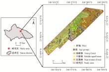
Fig.1
Location of study area and distribution of sample plots"

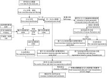
Fig.2
Comparison of individual tree segmentation methods for ULS data and technical route of accuracy analysis"


Fig.3
Results and accuracy of two methods of individual tree segmentation for the forest with different age groups"

Table 1
The basic profile of the sample plots of the 3 age groups and the segmentation accuracy of individual trees corresponding to the 2 segmentation algorithms in each age group"
| 龄组 Age groups | 样地数量 Number of sample plots | 平均郁闭度 Average canopy cover | 分水岭算法 Watershed algorithm | 基于点云的局部最大值聚类算法 Local maximum clustering algorithm based on point cloud | |||||
| r | p | F | r | p | F | ||||
| 幼龄林 Young forest | 13 | 0.82 | 0.70 | 0.89 | 0.78 | 0.53 | 0.92 | 0.64 | |
| 中龄林 Middle-aged forest | 14 | 0.79 | 0.60 | 0.80 | 0.68 | 0.53 | 0.88 | 0.66 | |
| 近熟林 Near-mature forest | 9 | 0.82 | 0.60 | 0.79 | 0.67 | 0.72 | 0.85 | 0.77 | |
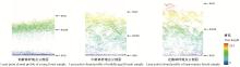
Fig.4
Point cloud profile of different age groups sample"

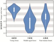
Fig.5
Violin plot of canopy relief ratio of three age groups in sample plot"
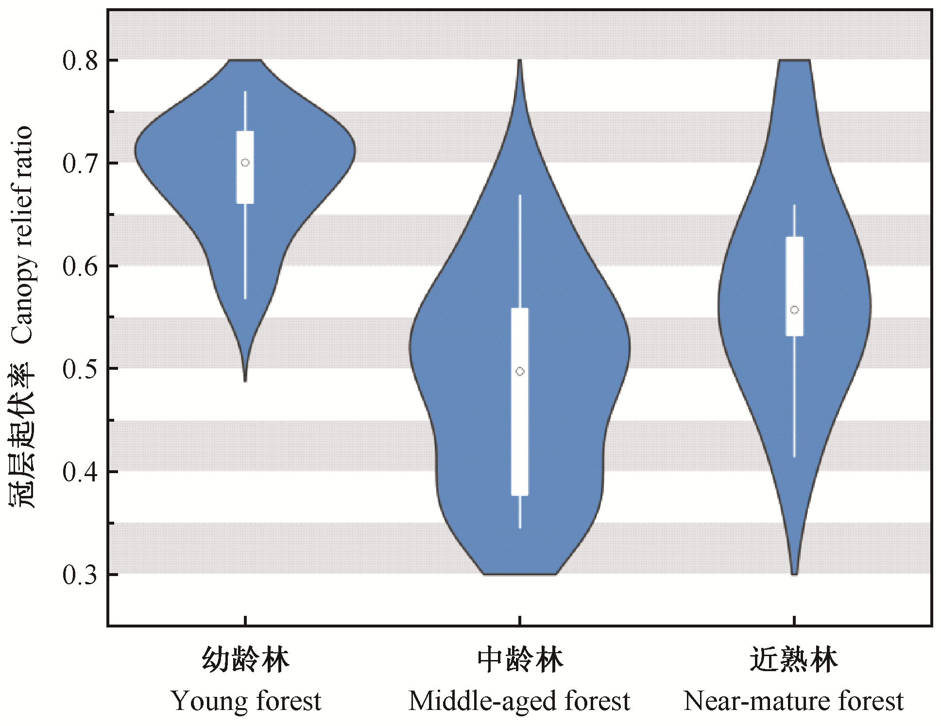
Table 2
Accuracy assessments of individual tree segmentation"
| 精度验证指标 Index for accuracy assessments | 分水岭算法 Watershed algorithm | 基于点云的局部最大值聚类算法 Local maximum clustering algorithm based on point cloud | 基于冠层起伏率的点云分层分割法 layered segmentation method based on CRR, combined with watershed algorithm and the local maximum clustering algorithm based on point cloud |
| r | 0.63 | 0.58 | 0.67 |
| p | 0.83 | 0.89 | 0.86 |
| F | 0.71 | 0.68 | 0.75 |
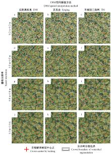
Fig.6
Segmentation accuracy of three spatial interpolation methods at different resolutions"

Table 3
Influence of CHM resolution and interpolation method on segmentation accuracy in watershed algorithm"
| CHM空间分辨率 CHM resolutions | 指标 Index | 插值方法Interpolation method | ||
| 反距离权重 IDW | 克里金 Kriging | 不规则三角网 TIN | ||
| 0.2 m×0.2 m | r | 1.00 | 1.00 | 1.00 |
| p | 0.28 | 0.25 | 0.26 | |
| F | 0.44 | 0.40 | 0.42 | |
| 0.5 m×0.5 m | r | 0.70 | 0.73 | 0.73 |
| p | 0.94 | 0.89 | 0.82 | |
| F | 0.81 | 0.80 | 0.77 | |
| 0.8 m×0.8 m | r | 0.32 | 0.32 | 0.43 |
| p | 0.93 | 0.93 | 0.95 | |
| F | 0.47 | 0.47 | 0.59 | |
| 1.0 m×1.0 m | r | 1.00 | 1.00 | 1.00 |
| p | 0.23 | 0.23 | 0.30 | |
| F | 0.37 | 0.37 | 0.46 | |
| 郭昱杉, 刘庆生, 刘高焕, 等. 基于标记控制分水岭分割方法的高分辨率遥感影像单木树冠提取. 地球信息科学学报, 2016, 18 (9): 1259- 1266. | |
| Guo Y S , Liu Q S , Liu G H , et al. Individual tree crown extraction of high resolution image based on marker-controlled watershed segmentation method. Journal of Geo-Information Science, 2016, 18 (9): 1259- 1266. | |
|
韩悬, 马银平. 分水岭算法的改进及在图像分割中的应用. 现代信息科技, 2019, 3 (24): 17- 19.
doi: 10.3969/j.issn.2096-4706.2019.24.006 |
|
|
Han X , Ma Y P . Improvement of watershed algorithm and its application in image segmentation. Modern Information Technology, 2019, 3 (24): 17- 19.
doi: 10.3969/j.issn.2096-4706.2019.24.006 |
|
| 霍朗宁, 张晓丽. 基于机载LiDAR点云多层聚类的单木信息提取及其精度评价. 林业科学, 2021, 57 (1): 85- 94. | |
| Huo L N , Zhang X L . Individual tree information extraction and accuracy evaluation based on airborne LiDAR point cloud by multilayer clustering method. Scientia Silvae Sinicae, 2021, 57 (1): 85- 94. | |
|
李平昊, 申鑫, 代劲松, 等. 机载激光雷达人工林单木分割方法比较和精度分析. 林业科学, 2018, 54 (12): 127- 136.
doi: 10.11707/j.1001-7488.20181214 |
|
|
Li P H , Shen X , Dai J S , et al. Comparisons and accuracy assessments of LiDAR-based tree segmentation approaches in planted forests. Scientia Silvae Sinicae, 2018, 54 (12): 127- 136.
doi: 10.11707/j.1001-7488.20181214 |
|
| 李增元, 刘清旺, 庞勇. 激光雷达森林参数反演研究进展. 遥感学报, 2016, 20 (5): 1138- 1150. | |
| Li Z Y , Liu Q W , Pang Y . Review on forest parameters inversion using LiDAR. Journal of Remote Sensing, 2016, 20 (5): 1138- 1150. | |
|
刘鲁霞, 庞勇. 机载激光雷达和地基激光雷达林业应用现状. 世界林业研究, 2014, 27 (1): 49- 56.
doi: 10.13348/j.cnki.sjlyyj.2014.01.009 |
|
|
Liu L X , Pang Y . Applications of airborne laser scanning and terrestrial laser scanning to forestry. World Forestry Research, 2014, 27 (1): 49- 56.
doi: 10.13348/j.cnki.sjlyyj.2014.01.009 |
|
|
刘清旺, 李增元, 陈尔学, 等. 机载LIDAR点云数据估测单株木生物量. 高技术通讯, 2010, 20 (7): 765- 770.
doi: 10.3772/j.issn.1002-0470.2010.07.019 |
|
|
Liu Q W , Li Z Y , Chen E X , et al. Estimating biomass of individual trees using point cloud data of airborne LiDAR. Chinese High Technology Letters, 2010, 20 (7): 765- 770.
doi: 10.3772/j.issn.1002-0470.2010.07.019 |
|
| 欧光龙, 肖义发, 王俊峰, 等. 思茅松天然林树冠结构模型. 生态学报, 2014, 34 (7): 1663- 1671. | |
| Ou G L , Xiao Y F , Wang J F , et al. Modeling tree crown structure of Simao pine (Pinus kesiya var. langbianensis) natural forest. Acta Ecologica Sinica, 2014, 34 (7): 1663- 1671. | |
|
潘瑶, 苏凯文, 张婉洁, 等. 面向可持续的国有林场森林生态系统管理研究: 以云南省万掌山国有林场为例. 林业调查规划, 2016, 41 (6): 64- 67.
doi: 10.3969/j.issn.1671-3168.2016.06.012 |
|
|
Pan Y , Su K W , Zhang W J , et al. Sustainable forest ecosystem management of state forest farm: a case study of Wanzhangshan forest farm. Forest Inventory and Planning, 2016, 41 (6): 64- 67.
doi: 10.3969/j.issn.1671-3168.2016.06.012 |
|
|
孙钊, 潘磊, 谢运鸿, 等. 分水岭算法在林业中的应用. 世界林业研究, 2021, 34 (3): 63- 67.
doi: 10.13348/j.cnki.sjlyyj.2020.0102.y |
|
|
Sun Z , Pan L , Xie Y H , et al. Application of watershed algorithm to forestry. World Forestry Research, 2021, 34 (3): 63- 67.
doi: 10.13348/j.cnki.sjlyyj.2020.0102.y |
|
|
Alexander C . Delineating tree crowns from airborne laser scanning point cloud data using Delaunay triangulation. International Journal of Remote Sensing, 2009, 30 (14): 3843- 3848.
doi: 10.1080/01431160902842318 |
|
|
Brandtberg T , Warner T A , Landenberger R E , et al. Detection and analysis of individual leaf-off tree crowns in small footprint, high sampling density LiDAR data from the eastern deciduous forest in North America. Remote Sensing of Environment, 2003, 85 (3): 290- 303.
doi: 10.1016/S0034-4257(03)00008-7 |
|
|
Brandtberg T . Classifying individual tree species under leaf-off and leaf-on conditions using airborne LiDAR. ISPRS Journal of Photogrammetry and Remote Sensing, 2007, 61 (5): 325- 340.
doi: 10.1016/j.isprsjprs.2006.10.006 |
|
| Chen Q , Baldocchi D , Gong P , et al. Isolating individual trees in a savanna woodland using small footprint LiDAR data. Photogrammetric Engineering & Remote Sensing, 2006, 72 (8): 923- 932. | |
|
Falkowski M J , Smith A M S , Gessler P E , et al. The influence of conifer forest canopy cover on the accuracy of two individual tree measurement algorithms using LiDAR data. Canadian Journal of Remote Sensing, 2008, 34 (sup2): S338- S350.
doi: 10.5589/m08-055 |
|
|
Ferraz A , Bretar F , Jacquemoud S , et al. 3-D mapping of a multi-layered Mediterranean forest using ALS data. Remote Sensing of Environment, 2012, 121, 210- 223.
doi: 10.1016/j.rse.2012.01.020 |
|
|
Forzieri G , Guarnieri L , Vivoni E R , et al. Multiple attribute decision making for individual tree detection using high-resolution laser scanning. Forest Ecology and Management, 2009, 258 (11): 2501- 2510.
doi: 10.1016/j.foreco.2009.09.006 |
|
| Goutte C, Gaussier E. 2005. A probabilistic interpretation of precision, recall and F-score, with implication for evaluation. European Conference on Information Retrieval, Springer, Berlin, Heidelberg, 345-359. | |
| Hyyppä J . Detecting and estimating attributes for single trees using laser scanner. Photogramm J Finland, 1999, 16, 27- 42. | |
| Johan H , Mats N , Håkan O . Estimation of tree height and stem volume on plots using airborne laser scanning. Forest Science, 2003, 49 (3): 419- 428. | |
|
Kaartinen H , Hyyppä J , Yu X W , et al. An international comparison of individual tree detection and extraction using airborne laser scanning. Remote Sensing, 2012, 4 (4): 950- 974.
doi: 10.3390/rs4040950 |
|
| Koch B , Heyder U , Weinacker H . Detection of individual tree crowns in airborne LiDAR data. Photogrammetric Engineering & Remote Sensing, 2006, 72 (4): 357- 363. | |
| Korpela I, Dahlin B, Schäfer H, et al. 2007. Single-tree forest inventory using LiDAR and aerial images for 3D treetop positioning, species recognition, height and crown width estimation. Proceedings of ISPRS Workshop on Laser Scanning, 227-233. | |
| Lee H , Slatton K C , Roth B E , et al. Adaptive clustering of airborne LiDAR data to segment individual tree crowns in managed pine forests. International Journal of Remote Sensing, 2010, 31 (1): 117- 139. | |
| Li W K , Guo Q H , Jakubowski M K , et al. A new method for segmenting individual trees from the LiDAR point cloud. Photogrammetric Engineering & Remote Sensing, 2012, 78 (1): 75- 84. | |
| Maltamo M , Eerikäinen K , Pitkänen J , et al. Estimation of timber volume and stem density based on scanning laser altimetry and expected tree size distribution functions. Remote Sensing of Environment, 2004, 90 (3): 319- 330. | |
| Mei C , Durrieu S . Tree crown delineation from digital elevation models and high resolution imagery. Proc. IAPRS, 2004, 36, 218- 223. | |
| Meyer F , Beucher S . Morphological segmentation. Journal of Visual Communication and Image Representation, 1990, 1 (1): 21- 46. | |
| Nuijten R J G , Coops N C , Goodbody T R H , et al. Examining the multi-seasonal consistency of individual tree segmentation on deciduous stands using digital aerial photogrammetry (DAP) and unmanned aerial systems (UAS). Remote Sensing, 2019, 11 (7): 739. | |
| Parker G G , Russ M E . The canopy surface and stand development: assessing forest canopy structure and complexity with near-surface altimetry. Forest Ecology and Management, 2004, 189 (1/3): 307- 315. | |
| Pedersen R Ø , Bollandsås O M , Gobakken T , et al. Deriving individual tree competition indices from airborne laser scanning. Forest Ecology and Management, 2012, 280, 150- 165. | |
| Popescu S C , Wynne R H , Nelson R F . Estimating plot-level tree heights with LiDAR: local filtering with a canopy-height based variable window size. Computers and Electronics in Agriculture, 2003, 37 (1/3): 71- 95. | |
| Popescu S C . Estimating biomass of individual pine trees using airborne LiDAR. Biomass and Bioenergy, 2007, 31 (9): 646- 655. | |
| Reitberger J , Schnörr C , Krzystek P , et al. 3D segmentation of single trees exploiting full waveform LiDAR data. ISPRS Journal of Photogrammetry and Remote Sensing, 2009, 64 (6): 561- 574. | |
| Siepielski A M , Morrissey M B , Buoro M , et al. Precipitation drives global variation in natural selection. Science, 2017, 355 (6328): 959- 962. | |
| Sokolova M, Japkowicz N, Szpakowicz S. 2006. Beyond accuracy, F-score and ROC: a family of discriminant measures for performance evaluation. Lecture Notes in Computer Science. Berlin, Heidelberg: Springer Berlin Heidelberg, 1015-1021. | |
| Tang F F, Zhang X H, Liu J N. 2007. Segmentation of tree crown model with complex structure from airborne LiDAR data. Proc SPIE 6752, Geoinformatics 2007: Remotely Sensed Data and Information, 94-102. | |
| Vauhkonen J , Ene L , Gupta S , et al. Comparative testing of single-tree detection algorithms under different types of forest. Forestry: an International Journal of Forest Research, 2011, 85 (1): 27- 40. | |
| Vincent L , Soille P . Watersheds in digital spaces: an efficient algorithm based on immersion simulations. IEEE Transactions on Pattern Analysis and Machine Intelligence, 1991, 13 (6): 583- 598. | |
| Wulder M , Niemann K O , Goodenough D G . Local maximum filtering for the extraction of tree locations and basal area from high spatial resolution imagery. Remote Sensing of Environment, 2000, 73 (1): 103- 114. | |
| Yang Q L , Su Y J , Jin S C , et al. The influence of vegetation characteristics on individual tree segmentation methods with airborne LiDAR data. Remote Sensing, 2019, 11 (23): 2880. | |
| Yu X W , Hyyppä J , Vastaranta M , et al. Predicting individual tree attributes from airborne laser point clouds based on the random forests technique. ISPRS Journal of Photogrammetry and Remote Sensing, 2011, 66 (1): 28- 37. | |
| Zhao K , Suarez J C , Garcia M , et al. Utility of multitemporal LiDAR for forest and carbon monitoring: tree growth, biomass dynamics, and carbon flux. Remote Sensing of Environment, 2018, 204, 883- 897. | |
| Zimble D A , Evans D L , Carlson G C , et al. Characterizing vertical forest structure using small-footprint airborne LiDAR. Remote Sensing of Environment, 2003, 87 (2/3): 171- 182. |
| Viewed | ||||||
|
Full text |
|
|||||
|
Abstract |
|
|||||