
Scientia Silvae Sinicae ›› 2026, Vol. 62 ›› Issue (2): 160-172.doi: 10.11707/j.1001-7488.LYKX20240782
• Research papers • Previous Articles
Zongqi Yao1,2,3,Lingting Lei1,2,3,Guoqi Chai4,Langning Huo5,Xin Tian4,Xiaoli Zhang1,2,3,*( )
)
Received:2024-12-22
Revised:2025-09-15
Online:2026-02-25
Published:2026-03-04
Contact:
Xiaoli Zhang
E-mail:zhang-xl@263.net
CLC Number:
Zongqi Yao,Lingting Lei,Guoqi Chai,Langning Huo,Xin Tian,Xiaoli Zhang. Collaborative Detection Method with Spaceborne Multispectral and SAR Data for Land Cover and Forest Type Changes[J]. Scientia Silvae Sinicae, 2026, 62(2): 160-172.
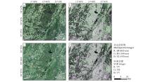
Fig.1
Remote sensing images of the study area"
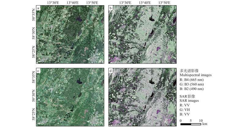

Fig.2
Examples of land cover change in study area"
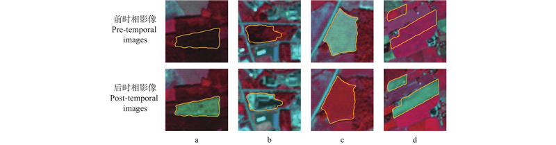
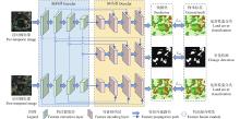
Fig.3
Overall framework of FCCDNet"
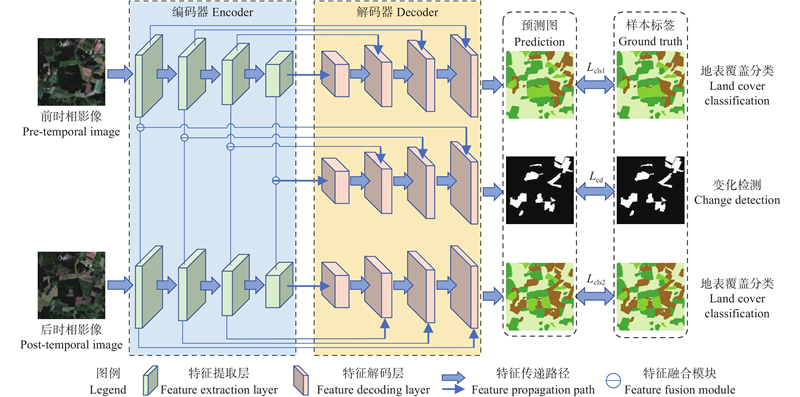
Fig.4
Bitemporal feature encoder"
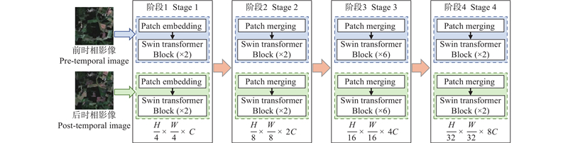
Fig.5
Decoder branch of FCCDNet"
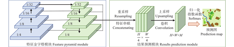
Table 1
Experimental design details"
| 试验名称 Experiment name | 试验目的 Experimental purpose | 变化检测算法 Change detection algorithms | 输入数据 Input data | |
| 前时相 Pre-temporal | 后时相 Post-temporal | |||
| 试验A Experiment A | 比较FCCDNet与其他变化 检测算法的性能 Comparing the performance of FCCDNet with other change detection algorithms | IR-MAD | Sentinel-2 | |
| dVIs | ||||
| BIT | ||||
| Random forest | ||||
| FCCDNet | ||||
| 试验B Experiment B | 检验不同输入数据的效果 Testing the performance of different input data | FCCDNet | Sentinel-2 | Sentinel-2 |
| Sentinel-2 | Sentinel-1 | |||
| Sentinel-1 | Sentinel-2 | |||
| Sentinel-1 | Sentinel-1 | |||
Table 2
Change detection and land cover classification accuracy using Sentinel-2 data"
| 算法Algorithm | 任务Task | 类别Type | 精度Accuracy (%) | |||
| F1-score | mF | IoU | mIoU | |||
| IR-MAD | 变化检测 Change detection | 未变化Unchanged | 81.27 | 77.68 | 76.71 | 71.77 |
| 变化changed | 74.09 | 66.83 | ||||
| dVIs | 变化检测 Change detection | 未变化Unchanged | 82.73 | 78.09 | 78.57 | 72.47 |
| 变化changed | 73.44 | 66.36 | ||||
| BIT | 变化检测 Change detection | 未变化Unchanged | 87.36 | 79.14 | 80.24 | 74.36 |
| 变化changed | 75.91 | 68.48 | ||||
| Random forest | 地表覆盖分类 Land cover classification | 针叶林Coniferous forest | 90.28 | 90.29 | 86.54 | 84.95 |
| 阔叶林Broad-leaved forest | 83.61 | 78.94 | ||||
| 其他植被Other vegetation | 88.75 | 81.27 | ||||
| 水体Water | 97.34 | 94.82 | ||||
| 其他非植被地表 Other non-vegetation surfaces | 91.47 | 83.17 | ||||
| FCCDNet | 变化检测 Change detection | 未变化Unchanged | 96.28 | 90.56 | 92.83 | 84.25 |
| 变化changed | 84.83 | 75.66 | ||||
| 地表覆盖分类 Land cover classification | 针叶林Coniferous forest | 94.75 | 93.26 | 90.03 | 87.49 | |
| 阔叶林Broad-leaved forest | 89.11 | 80.36 | ||||
| 其他植被Other vegetation | 91.74 | 84.74 | ||||
| 水体Water | 97.49 | 95.1 | ||||
| 其他非植被地表 Other non-vegetation surfaces | 93.19 | 87.25 | ||||
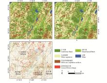
Fig.6
Land cover classification and change detection map using Sentinel-2 image and FCCDNet"
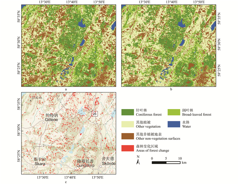
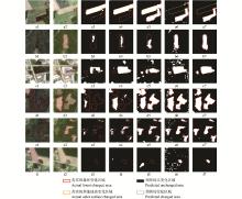
Fig.7
Comparison of Sentinel-2 image change detection results"
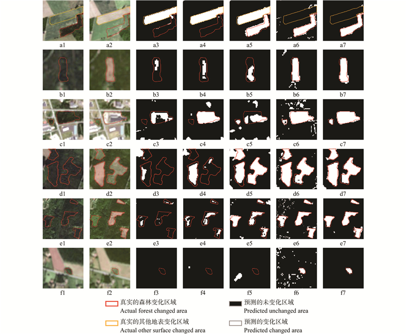
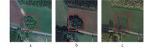
Fig.8
High resolution Google image of “Fig. 7f”"
Table 3
Accuracy of land cover classification and change detection for multi-source data based on FCCDNet"
| 前时相 数据 Pre-temporal data | 后时相 数据 Post-temporal data | 任务Task | 精度Accuracy | |
| mF(%) | mIoU(%) | |||
| Sentinel-2 | Sentinel-2 | 变化检测 Change detection | 90.56 | 84.25 |
| 地表覆盖分类 Land cover classification | 93.26 | 87.49 | ||
| Sentinel-2 | Sentinel-1 | 变化检测 Change detection | 76.68 | 64.58 |
| 地表覆盖分类 Land cover classification | 74.87 | 61.00 | ||
| Sentinel-1 | Sentinel-2 | 变化检测 Change detection | 75.07 | 62.66 |
| 地表覆盖分类 Land cover classification | 73.80 | 59.73 | ||
| Sentinel-1 | Sentinel-1 | 变化检测 Change detection | 65.94 | 55.88 |
| 地表覆盖分类 Land cover classification | 65.81 | 54.04 | ||

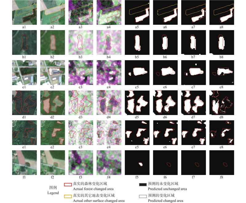
Fig.9
Comparison of forest change detection results with multiple data sources"
| 冯林艳, 谭炳香, 王晓慧, 等. 基于高分二号影像的森林变化快速检测方法研究. 林业科学研究, 2019, 32 (5): 142- 148. | |
| Feng L Y, Tan B X, Wang X H, et al. Study on rapid forest change detection method based on GF-2 images. Forest Research, 2019, 32 (5): 142- 148. | |
| 李春干, 代华兵. 基于统计检验的面向对象高分辨率遥感图像森林变化检测. 林业科学, 2017, 53 (5): 74- 81. | |
| Li C G, Dai H B. Statistical object-based method for forest change detection using high-resolution remote sensing images. Scientia Silvae Sinicae, 2017, 53 (5): 74- 81. | |
| 李德仁. 利用遥感影像进行变化检测. 武汉大学学报(信息科学版), 2003 (S1): 7- 12. | |
| Li D R. Change detection from remote sensing images. Geomatics and Information Science of Wuhan University, 2003 (S1): 7- 12. | |
| 王崇阳, 田 昕. 基于GF-1 PMS数据的森林覆盖变化检测. 遥感技术与应用, 2021, 36 (1): 208- 216. | |
| Wang C Y, Tian X. Forest cover change detection based on GF-1 PMS data. Remote Sensing Technology and Application, 2021, 36 (1): 208- 216. | |
| 王晓强. 基于高分辨率遥感影像的厦门市森林资源动态监测与管理方法研究. 测绘与空间地理信息, 2021, 44 (12): 94- 97. | |
| Wang X Q. Research on dynamic monitoring and management methods of forest resources in Xiamen city based on high-resolution remote sensing images. Geomatics & Spatial Information Technology, 2021, 44 (12): 94- 97. | |
| 张良培, 武 辰. 多时相遥感影像变化检测的现状与展望. 测绘学报, 2017, 46 (10): 1447- 1459. | |
| Zhang L P, Wu C. Advance and future development of change detection for multi-temporal remote sensing imagery. Acta Geodaetica et Cartographica Sinica, 2017, 46 (10): 1447- 1459. | |
|
Alshehri M, Ouadou A, Scott G J. Deep transformer-based network deforestation detection in the Brazilian Amazon using Sentinel-2 imagery. IEEE Geoscience and Remote Sensing Letters, 2024, 21, 1- 5.
doi: 10.1109/LGRS.2024.3355104 |
|
|
Bu L J, Zhang J Y, Zhang Z P, et al. Enhancing RABASAR for multi-temporal SAR image despeckling through directional filtering and wavelet transform. Sensors, 2023, 23 (21): 8916.
doi: 10.3390/s23218916 |
|
| Chen H, Qi Z P, Shi Z W. Remote sensing image change detection with transformers. IEEE Transactions on Geoscience and Remote Sensing, 2022, 60, 1- 14. | |
|
Cheng J D, Zhang F, Xiang D L, et al. PolSAR image land cover classification based on hierarchical capsule network. Remote Sensing, 2021, 13 (16): 3132.
doi: 10.3390/rs13163132 |
|
|
Cheng K, Su Y J, Guan H C, et al. Mapping China's planted forests using high resolution imagery and massive amounts of crowdsourced samples. ISPRS Journal of Photogrammetry and Remote Sensing, 2023, 196, 356- 371.
doi: 10.1016/j.isprsjprs.2023.01.005 |
|
|
Choi H, Jeong J. Speckle noise reduction technique for SAR images using statistical characteristics of speckle noise and discrete wavelet transform. Remote Sensing, 2019, 11 (10): 1184.
doi: 10.3390/rs11101184 |
|
|
Curtis P G, Slay C M, Harris N L, et al. Classifying drivers of global forest loss. Science, 2018, 361 (6407): 1108- 1111.
doi: 10.1126/science.aau3445 |
|
|
Deng J S, Wang K, Deng Y H, et al. PCA-based land-use change detection and analysis using multitemporal and multisensor satellite data. International Journal of Remote Sensing, 2008, 29 (16): 4823- 4838.
doi: 10.1080/01431160801950162 |
|
| Dosovitskiy A, Beyer L, Kolesnikov A, et al. 2021., An image is worth 16x16 words: transformers for image recognition at scale.. International Conference on Learning Representations, 611−631.. | |
|
Hu J R, Zhang Y. Seasonal change of land-use/land-cover (LULC) detection using MODIS data in rapid urbanization regions: a case study of the pearl river delta region (China). IEEE Journal of Selected Topics in Applied Earth Observations and Remote Sensing, 2013, 6 (4): 1913- 1920.
doi: 10.1109/JSTARS.2012.2228469 |
|
|
Im J, Jensen J R. A change detection model based on neighborhood correlation image analysis and decision tree classification. Remote Sensing of Environment, 2005, 99 (3): 326- 340.
doi: 10.1016/j.rse.2005.09.008 |
|
|
Isaienkov K, Yushchuk M, Khramtsov V, et al. Deep learning for regular change detection in Ukrainian forest ecosystem with Sentinel-2. IEEE Journal of Selected Topics in Applied Earth Observations and Remote Sensing, 2021, 14, 364- 376.
doi: 10.1109/JSTARS.2020.3034186 |
|
|
John D, Zhang C. An attention-based U-Net for detecting deforestation within satellite sensor imagery. International Journal of Applied Earth Observation and Geoinformation, 2022, 107, 102685.
doi: 10.1016/j.jag.2022.102685 |
|
|
Latifi H, Heurich M. Multi-scale remote sensing-assisted forest inventory: a glimpse of the state-of-the-art and future prospects. Remote Sensing, 2019, 11 (11): 1260.
doi: 10.3390/rs11111260 |
|
|
Liu T, Yang L X, Lunga D. Change detection using deep learning approach with object-based image analysis. Remote Sensing of Environment, 2021a, 256, 112308.
doi: 10.1016/j.rse.2021.112308 |
|
| Liu Z, Lin Y T, Cao Y, et al. 2021b. Swin Transformer: hierarchical vision transformer using shifted windows. 2021 IEEE/CVF International Conference on Computer Vision (ICCV), 9992−10002. | |
|
Martone M, Rizzoli P, Wecklich C, et al. The global forest/non-forest map from TanDEM-X interferometric SAR data. Remote Sensing of Environment, 2018, 205, 352- 373.
doi: 10.1016/j.rse.2017.12.002 |
|
|
Molini A B, Valsesia D, Fracastoro G, et al. Speckle2Void: deep self-supervised SAR despeckling with blind-spot convolutional neural networks. IEEE Transactions on Geoscience and Remote Sensing, 2022, 60, 1- 17.
doi: 10.1109/TGRS.2021.3065461 |
|
|
Nemmour H, Chibani Y. Multiple support vector machines for land cover change detection: an application for mapping urban extensions. ISPRS Journal of Photogrammetry and Remote Sensing, 2006, 61 (2): 125- 133.
doi: 10.1016/j.isprsjprs.2006.09.004 |
|
|
Nielsen A A. The regularized iteratively reweighted MAD method for change detection in multi- and hyperspectral data. IEEE Transactions on Image Processing, 2007, 16 (2): 463- 478.
doi: 10.1109/TIP.2006.888195 |
|
|
Sebastianelli A, Rosso M P D, Ullo S L, et al. A speckle filter for Sentinel-1 SAR ground range detected data based on residual convolutional neural networks. IEEE Journal of Selected Topics in Applied Earth Observations and Remote Sensing, 2022, 15, 5086- 5101.
doi: 10.1109/JSTARS.2022.3184355 |
|
|
Seidl R, Spies T A, Peterson D L, et al. Searching for resilience: addressing the impacts of changing disturbance regimes on forest ecosystem services. Journal of Applied Ecology, 2016, 53 (1): 120- 129.
doi: 10.1111/1365-2664.12511 |
|
|
Su H, Zhang X Z, Luo Y Q, et al. Nonlocal feature learning based on a variational graph auto-encoder network for small area change detection using SAR imagery. ISPRS Journal of Photogrammetry and Remote Sensing, 2022, 193, 137- 149.
doi: 10.1016/j.isprsjprs.2022.09.006 |
|
|
Wittstruck L, Jarmer T, Waske B. Multi-stage feature fusion of multispectral and SAR satellite images for seasonal crop-type mapping at regional scale using an adapted 3D U-Net model. Remote Sensing, 2024, 16 (17): 3115.
doi: 10.3390/rs16173115 |
|
|
Wessels K J, Van den Bergh F, Roy D P, et al. Rapid land cover map updates using change detection and robust random forest classifiers. Remote Sensing, 2016, 8 (11): 888.
doi: 10.3390/rs8110888 |
|
|
Xiao P F, Sheng G W, Zhang X L, et al. Direction-dominated change vector analysis for forest change detection. International Journal of Applied Earth Observation and Geoinformation, 2021, 103, 102492.
doi: 10.1016/j.jag.2021.102492 |
|
|
Zhang C X, Yue P, Tapete D, et al. A deeply supervised image fusion network for change detection in high resolution bi-temporal remote sensing images. ISPRS Journal of Photogrammetry and Remote Sensing, 2020, 166, 183- 200.
doi: 10.1016/j.isprsjprs.2020.06.003 |
|
|
Zhang C, Wang L J, Cheng S L, et al. SwinSUNet: pure transformer network for remote sensing image change detection. IEEE Transactions on Geoscience and Remote Sensing, 2022, 60, 1- 13.
doi: 10.1109/TGRS.2022.3160007 |
|
|
Zhang X, Zhao T T, Xu H, et al. GLC_FCS30D: the first global 30 m land-cover dynamics monitoring product with a fine classification system for the period from 1985 to 2022 generated using dense-time-series Landsat imagery and the continuous change-detection method. Earth System Science Data, 2024, 16 (3): 1353- 1381.
doi: 10.5194/essd-16-1353-2024 |
|
|
Zhao F, Sun R, Zhong L H, et al. Monthly mapping of forest harvesting using dense time series Sentinel-1 SAR imagery and deep learning. Remote Sensing of Environment, 2022, 269, 112822.
doi: 10.1016/j.rse.2021.112822 |
| [1] | Yaodi Li,Ye Tian,Changchun Zhang,Jiangjian Xie,Haitao Zhao,Junguo Zhang. Wildlife Image Recognition Methods and Challenges Based on Deep Learning [J]. Scientia Silvae Sinicae, 2026, 62(1): 207-222. |
| [2] | Caihong Duan,Hui Lin,Jiangping Long,Peisong Yang,Zilin Ye,Tingchen Zhang,Xunwei Li,Lixin Zhu. Remote Sensing Estimation of Eucalyptus Age and Stem Volume Combining Improved Simulating Continuous Change Detection with Classification Algorithm [J]. Scientia Silvae Sinicae, 2025, 61(4): 46-55. |
| [3] | Xiaoning Ge,Xinqiao Xu,Huaiqing Zhang,Jing Zhang,Jie Yang,Zeyu Cui,Rurao Fu,Jinjie Liang,Tianhua Zou,Linlong Wang,Yang Liu. Progress and Reflection on Genotype-Environment Interaction Algorithms in Forest Tree Breeding [J]. Scientia Silvae Sinicae, 2025, 61(3): 1-15. |
| [4] | Min Ji,Rui Gao,Xiaohuan Wang,Xingliang Diao,Jiakai Han,Yang Zhao,Guofu Wang,Wei Zhang. Online Detecting Method of Structural Lumber Knot Based on Deep Learning [J]. Scientia Silvae Sinicae, 2025, 61(11): 150-159. |
| [5] | Wanying Xie,Wenping Liu,Han Wang. UAV Images of Pine Forests for Early Detection of Pine Wood Nematode Infestation [J]. Scientia Silvae Sinicae, 2024, 60(9): 124-133. |
| [6] | Jiandong Qi,Shangzi Zheng,Ziyi Chen,Zhongtian Ma. Wildlife Image Recognition of Infrared Cameras in Beijing Area Based on an Improvement ConvNeXt Model [J]. Scientia Silvae Sinicae, 2024, 60(8): 33-45. |
| [7] | Guangdao Bao,Ting Liu,Zhonghui Zhang,Zhibin Ren,Chang Zhai,Mingming Ding,Xuefei Jiang. Remote Sensing Inversion of Effective Leaf Area Index of Four Coniferous Forest Types and Their Spatial Distribution Rule in Changbai Mountain [J]. Scientia Silvae Sinicae, 2024, 60(5): 127-138. |
| [8] | Lin Zhu,Lishui Nie,Ce Shi,Mengyao Huang,Xin Niu,Runzhe Zhang,Zhaode Zhang,Yifan Wei,Dengzhi Wang,Hao Yang,Haoliang Nie,Jiang Wang,HuiJuan Bo. Effects of Soil Properties and Stand Factors on nirK-Denitrifying Microbial Community in Songshan, Beijing [J]. Scientia Silvae Sinicae, 2024, 60(5): 139-150. |
| [9] | Zhikang Tian,Zhedong Ge,Huanqi Zheng,Zhishuai Zheng,Yucheng Zhou. Microscopic Identification Methods for 75 Types of Hardwood Based on Deep Neural Network [J]. Scientia Silvae Sinicae, 2024, 60(10): 94-103. |
| [10] | Jiandong Qi,Zhongtian Ma,Dehuai Zhang,Yun Tian. Wildlife Image Recognition in Miyun District Based on BS-ResNeXt-50 [J]. Scientia Silvae Sinicae, 2023, 59(8): 112-122. |
| [11] | Linyan Feng,Bingxiang Tan,Qingwang Liu,Chaofan Zhou,Hang Yu,Huiru Zhang,Liyong Fu. Land Cover and Tree Species Classification of the Chongli Winter Olympic Core Area Based on GF-2 Images [J]. Scientia Silvae Sinicae, 2022, 58(10): 10-23. |
| [12] | Jia Li,Lan Lan,Zuozhong Zhang,Wentao Yuan,Demin Gao,Shuqin Zong,Qiaolin Ye. Inversion Technology of Forest Fuel Moisture Content Based on Deep Learning [J]. Scientia Silvae Sinicae, 2022, 58(10): 47-58. |
| [13] | Hong Xia,Chunyan Xia,Haiyan Song,Yu Du,Jianping Tao. Seed Rain, Soil Seed Bank, and Seedling Regeneration of Woody Plants in Three Karst Forest Communities on Jinfo Mountain, Chongqing [J]. Scientia Silvae Sinicae, 2022, 58(1): 1-11. |
| [14] | Yan Zhou,Wenping Liu,Youqing Luo,Shixiang Zong. Small Object Detection for Infected Trees Based on the Deep Learning Method [J]. Scientia Silvae Sinicae, 2021, 57(3): 98-107. |
| [15] | Ting Ma,Chonggui Li,Fuquan Tang,Jie Lü. Extraction of Larch Plantation Based on Multi-Classifier Ensemble [J]. Scientia Silvae Sinicae, 2021, 57(11): 105-118. |
| Viewed | ||||||
|
Full text |
|
|||||
|
Abstract |
|
|||||