
林业科学 ›› 2020, Vol. 56 ›› Issue (1): 74-86.doi: 10.11707/j.1001-7488.20200108
吴项乾,曹林*,申鑫,汪贵斌,曹福亮
收稿日期:2018-01-10
出版日期:2020-01-25
发布日期:2020-02-24
通讯作者:
曹林
基金资助:Xiangqian Wu,Lin Cao*,Xin Shen,Guibin Wang,Fuliang Cao
Received:2018-01-10
Online:2020-01-25
Published:2020-02-24
Contact:
Lin Cao
Supported by:摘要:
目的: 精确估测银杏人工林有效叶面积指数(eLAI),以更好了解银杏人工林的生长和竞争、理解人工林生态系统的功能和生产力。方法: 基于多旋翼无人机激光雷达(LiDAR)系统获取的点云数据,结合45块地面实测样地数据,使用孔隙度模型法(通过计算点云的冠层穿透率,根据Beer-Lambert定律计算有效叶面积指数)和统计模型法(首先通过地面实测的有效叶面积指数和所提取的LiDAR特征变量建模,然后借助拟合的模型估测有效叶面积指数)对我国典型银杏人工林进行样地尺度的有效叶面积指数估测。结果: 1)使用统计模型法估测eLAI时,仅利用LiDAR高度特征变量估测精度为R2=0.38(rRMSE=54%),引入其他特征变量(冠层密度特征、冠层容积比以及强度特征变量)后精度分别达到R2=0.64(rRMSE=26%)、R2=0.61(rRMSE=28%)、R2=0.74(rRMSE=23%);2)根据Cover将样地分组建模后发现,分组建模的精度优于不分组建模的精度;3)孔隙度模型法估测有效叶面积指数的精度为R2=0.71(rRMSE=32.0%)。结论: 结合多组LiDAR特征变量估测有效叶面积指数能够充分挖掘LiDAR数据包含的冠层结构特性,从而提升估测精度;同时,使用孔隙度模型法可以有效估测银杏人工林有效叶面积指数。无人机LiDAR点云在估测银杏人工林有效叶面积指数上具有较好的潜力。
中图分类号:
吴项乾,曹林,申鑫,汪贵斌,曹福亮. 基于无人机激光雷达的银杏人工林有效叶面积指数估测[J]. 林业科学, 2020, 56(1): 74-86.
Xiangqian Wu,Lin Cao,Xin Shen,Guibin Wang,Fuliang Cao. Estimation of Effective Leaf Area Index Using UAV-Based LiDAR in Ginkgo Plantations[J]. Scientia Silvae Sinicae, 2020, 56(1): 74-86.
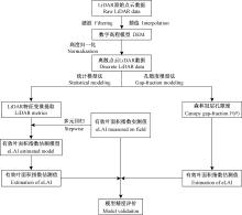
图1
研究技术路线"

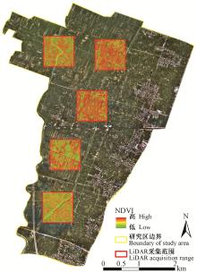
图2
研究区正射影像及样地空间分布"

表1
研究区样地林分参数调查信息汇总"
| 组 Group | 胸径 DBH/cm | Lorey’s平均树高 Lorey’s mean height/m | 株数 Number of stems | 密度 Density/hm-2 | 有效叶面积指数 eLAI/(m2·m-2) | |||||||||
| 范围 Range | 平均值 Mean | 范围 Range | 平均值 Mean | 范围 Range | 平均值 Mean | 范围 Range | 平均值 Mean | 范围 Range | 平均值 Mean | |||||
| 第1组Group 1 | 10.2~22.9 | 15.2 | 6.6~13.4 | 9.5 | 23~94 | 41.5 | 312~1 332 | 602.7 | 1.03~2.89 | 2.15 | ||||
| 第2组Group 2 | 16.0~23.4 | 19.5 | 10.1~14.5 | 12.2 | 22~54 | 37.6 | 328~952 | 533.6 | 0.93~2.42 | 1.67 | ||||
| 第3组Group 3 | 15.6~21.0 | 18.9 | 10.6~14.6 | 12.2 | 30~79 | 45.4 | 440~1 120 | 631.5 | 0.27~1.62 | 0.95 | ||||
| 全部样地All | 10.2~23.4 | 17.9 | 6.6~14.6 | 11.3 | 23~94 | 41.2 | 312~1 332 | 598.2 | 0.27~2.89 | 1.59 | ||||
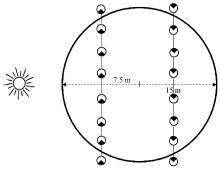
图3
有效叶面积指数地面实测方法示意"

表2
LiDAR特征变量及其描述"
| 特征变量Metrics | 变量描述Description |
| 高度百分位数Height percentiles | |
| h25,h50,h75,h95 | 森林冠层首次回波高度垂直分布的分位数The percentiles of the canopy height distributions by first echo(25th, 50th, 75th, and 95th) |
| hmean | 归一化点云高度的平均值The mean height of all points after normalized |
| hcv | 归一化点云高度的变异系数(标准差与平均数的比值)The coefficient of variation of height of all points after normalized(the ratio of the standard deviation to the mean) |
| hskewness/hkurtosis | 首次回波所有激光雷达高度点分布的偏度(分布曲线偏斜方向和程度)/峭度(分布曲线顶端的高耸程度) The skewness and kurtosis of the heights of all points by first echo |
| 冠层密度Ganopy density | |
| d1, d3, d5, d7, d9 | 大于10%、30%、50%、70%、90%高度的植被点占所有激光点的比例The proportion of points above the quantiles(10th, 30th, 50th, 70th, and 90th)to total number of points |
| 覆盖度Goverage | |
| CC1 | 首次回波中高于1 m的激光返回点占所有返回点的比例The first return points above 1 m accounts for the percentage of all return points |
| Weibull特征变量Weibull metrics | |
| α/β | 枝叶剖面中Weibull模型分布的尺度(宽度)/形状(高度)参数The α and β parameter of the Weibull distribution fitted to foliage density profile |
| 冠层容积特征变量Canopy volume metrics | |
| Open/Closed | 在冠层容积模型中无体元区域的上层/下层The empty voxels located above and below the canopy respectively |
| Euphotic/Oligophotic | 在冠层容积模型中有体元区域的上65%区域和下35%区域The voxels located within an uppermost percentile(65%)of all filled grid cells of that column, and voxels located below the point in the profile |
| 强度特征变量Intensily metrics | |
| I25, I50, I75, I95 | 首次回波返回点的能量强度分布百分位数The percentiles of the intensity distributions by first echo(25th, 50th, 75th, and 95th) |
| Imean | 首次回波激光雷达强度的平均值The mean intensity of all points by first echo |
| Icv | 首次回波激光雷达强度的变异系数(标准差与平均数的比值)The coefficient of variation of intensity of LiDARby first echo(the ratio of the standard deviation to the mean) |
| Iskewness/Ikurtosis | 首次回波所有激光雷达强度分布的偏度(分布曲线偏斜方向和程度)/峭度(分布曲线顶端的高耸程度) The skewness and kurtosis of the intensity of LiDAR by first echo |
表3
不同特征变量组合作为预测变量的有效叶面积指数估测模型比较及精度评价"
| 特征变量组合 Metrics contained | 模型Model | R2 | RMSE/(m2·m-2) | rRMSE(%) | AIC |
| Model 1 (基于高度特征变量Height percentile) | -7.93×hcv-0.36×h75+0.49×h95 +1.58 | 0.44 | 0.74 | 48.3 | 202.5 |
| Model 2 (基于高度+密度特征变量 Height percentile+ density metrics) | -0.98×h75+0.78×h95+4.68×d5-0.45 | 0.67 | 0.70 | 43.2 | 172.1 |
| Model 3 (基于高度+冠层容积特征变量 Height percentile+canopy volume metrics) | 0.28×β-6.96×Open-5.03×Euphotic+3.98 | 0.65 | 0.71 | 43.8 | 175.2 |
| Model 4 (基于所有特征变量All LiDAR metrics) | -7.10×d3+0.10×CC1-0.03×I95+0.47 | 0.78 | 0.39 | 22.1 | 158.3 |
表4
不同Cover分组的有效叶面积指数估测模型比较及交叉验证精度评价"
| 组Group | 模型Model | R2 | RMSE/m2·m-2) | rRMSE(%) | AIC |
| 第1组Group 1 | 22.4×hcv+3.18×hskewness+11.06×d5-9.69 | 0.86 | 0.21 | 15.6 | 132.4 |
| 第2组Group 2 | 0.72×Iskewness+3.75×d5-6.85×d9-0.76 | 0.88 | 0.14 | 12.6 | 127.5 |
| 第3组Group 3 | -9.42×hcv+0.06×I25-0.01×CC1+2.04 | 0.79 | 0.37 | 21.9 | 150.2 |
| 总体样地All | -7.10×d3+0.10×CC1-0.03×I95+0.47 | 0.74 | 0.39 | 23.0 | 158.3 |
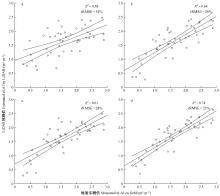
图4
地面实测eLAI与统计模型法预测eLAI交叉验证结果 a为基于高度特征变量建模;b为基于高度+密度特征变量建模;c为基于高度+冠层容积特征变量建模;d为基于所有提取的特征变量(含强度特征变量)建模。"
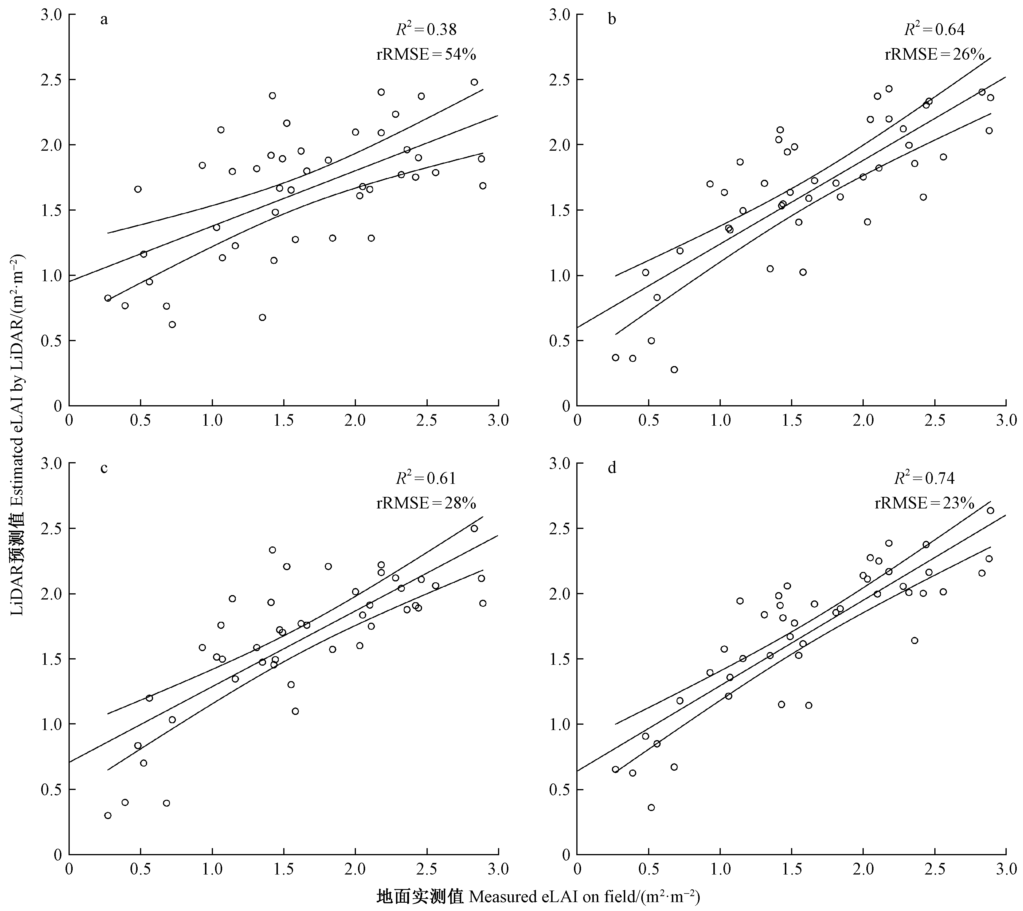
图5
不同Cover组地面实测eLAI与统计模型法预测eLAI交叉验证结果 a为第1组结果;b为第2组结果;c为第3组结果;d为所有样地结果。"
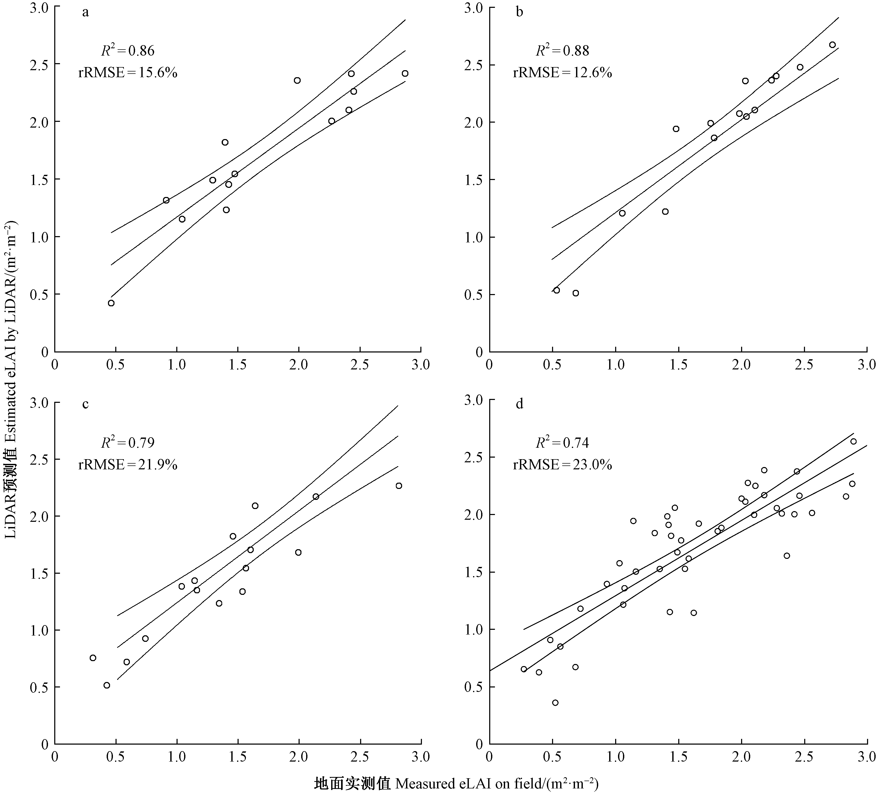
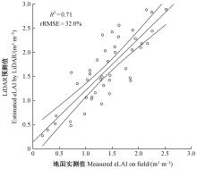
图6
孔隙度模型法估测eLAI与地面实测eLAI拟合精度"
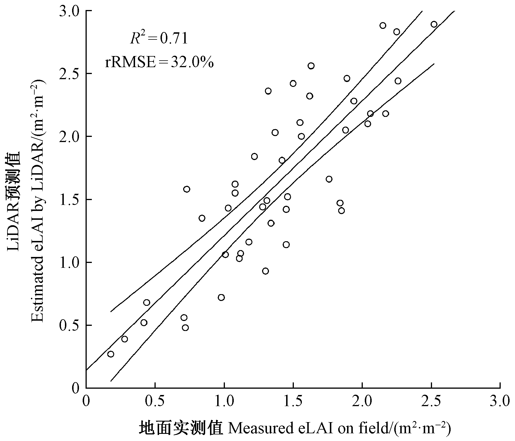
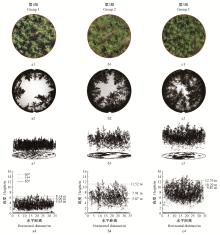
图7
3组典型样地正射影像(a1—c1)、球面镜影像(a2—c2)、激光雷达点云(a3—c3)及激光雷达点云剖面(含50、75、95高度分位数位置)(a4—c4)"


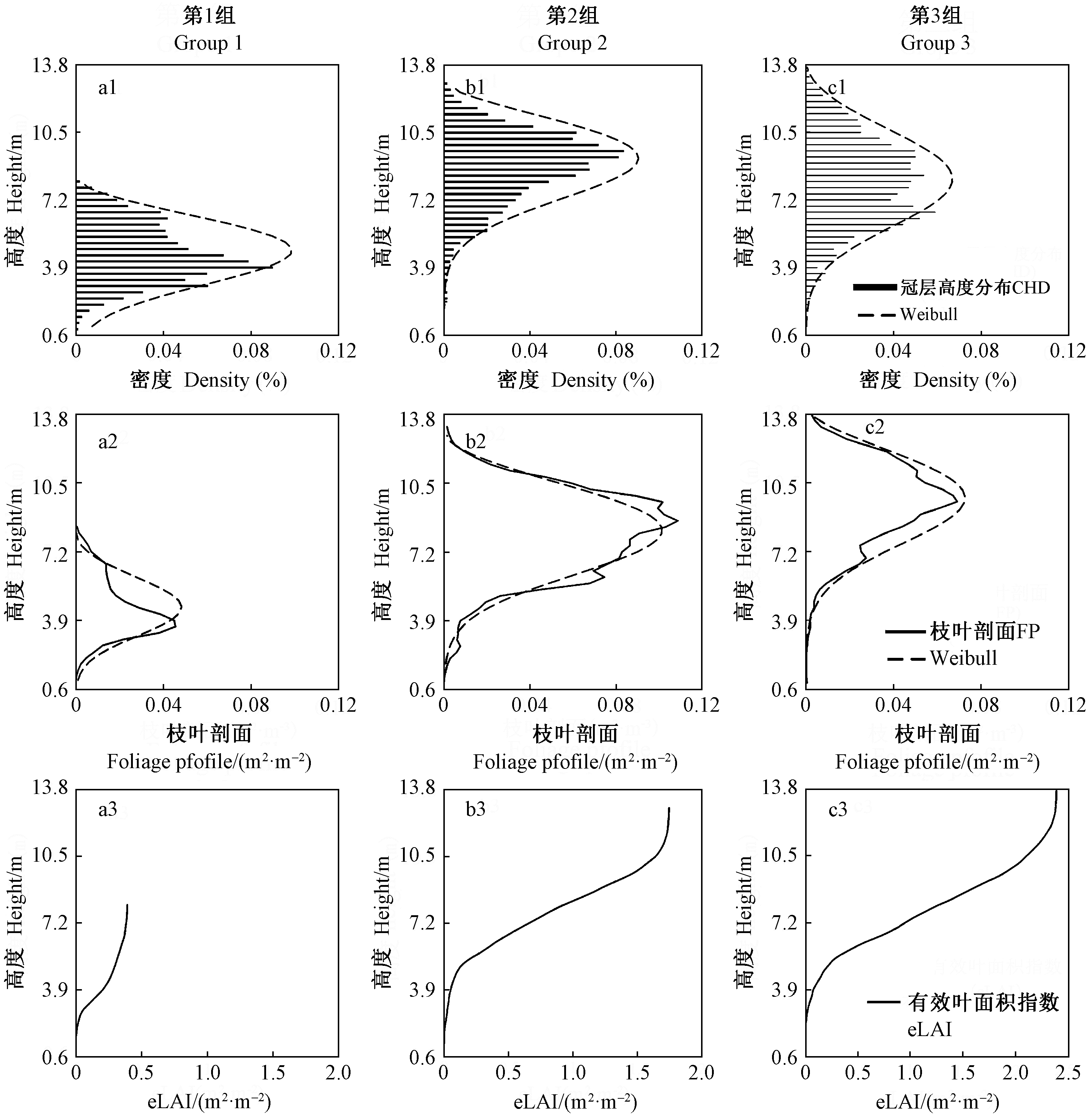
图8
3个典型样地冠层高度分布(CHD)(a1—c1)、枝叶剖面(FP)(a2—c2)与Weibull拟合曲线及有效叶面积指数(eLAI)累积曲线(a3—c3)"
| 曹福亮. 中国银杏志. 北京: 中国林业出版社. 2007. | |
| Cao F L . Chinese ginkgo. Beijing: China Forestry Publishing House. 2007. | |
| 曹林, 代劲松, 徐建新, 等. 基于机载小光斑LiDAR技术的亚热带森林参数信息优化提取. 北京林业大学学报, 2014. 36 (5): 13- 21. | |
| Cao L , Dai J S , Xu J X , et al. Optimized extraction of forest parameters in subtropical forests based on airborne small footprint LiDAR technology. Journal of Beijing Forestry University, 2014. 36 (5): 13- 21. | |
|
程武学, 潘开志, 杨存建. 叶面积指数(LAI)测定方法研究进展. 四川林业科技, 2010. 31 (3): 51- 54.
doi: 10.3969/j.issn.1003-5508.2010.03.007 |
|
|
Cheng W X , Pan K Z , Yang C J . Research progress in the determination methods of leaf area index(LAI). Journal of Sichuan Forestry Science and Technology, 2010. 31 (3): 51- 54.
doi: 10.3969/j.issn.1003-5508.2010.03.007 |
|
| 胡艳波, 惠刚盈, 王宏翔, 等. 随机分布的角尺度置信区间及其应用. 林业科学研究, 2014. 27 (3): 302- 308. | |
| Hu Y B , Hui G Y , Wang H X , et al. Uniform angle index(W) confidence interval of the random distribution and its application. Forest Research, 2014. 27 (3): 302- 308. | |
| 李德仁, 王长委, 胡月明, 等. 遥感技术估算森林生物量的研究进展. 武汉大学学报:信息科学版, 2012. 37 (6): 631- 635. | |
| Li D R , Wang C W , Hu Y M , et al. General review on remote sensing-based biomass estimation. Geomatics and Information Science of Wuhan University, 2012. 37 (6): 631- 635. | |
| 李增元, 刘清旺, 庞勇. 激光雷达森林参数反演研究进展. 遥感学报, 2016. 20 (5): 1138- 1150. | |
| Li Z Y , Liu Q W , Pang Y . Review on forest parameters inversion using LiDAR. Journal of Remote Sensing, 2016. 20 (5): 1138- 1150. | |
|
张佳华, 符淙斌, 延晓冬. 全球植被叶面积指数对温度和降水的响应研究. 地球物理学报, 2002. 45 (5): 631- 637.
doi: 10.3321/j.issn:0001-5733.2002.05.005 |
|
|
Zhang J H , Fu Z B , Yan X D . Global despondence analysis of LAI versus surface air temperature and precipitation variations. Chinese Journal of Geophysics, 2002. 45 (5): 631- 637.
doi: 10.3321/j.issn:0001-5733.2002.05.005 |
|
| 赵中华, 惠刚盈, 胡艳波, 等. 角尺度判断林木水平分布格局的新方法. 林业科学, 2016. 52 (2): 10- 16. | |
| Zhao Z H , Hui G Y , Hu Y B , et al. The new method judged horizontal distribution pattern by uniform angle index. Scientia Silvae Sinicae, 2016. 52 (2): 10- 16. | |
|
Akaike H . A new look at the statistical identification. Automatic Control IEEE Transactions on, 1974. 19 (6): 716- 723.
doi: 10.1109/TAC.1974.1100705 |
|
|
Bequet R , Campioli M , Kint V , et al. Leaf area index development in temperate oak and beech forests is driven by stand characteristics and weather conditions. Trees, 2011. 25 (5): 935- 946.
doi: 10.1007/s00468-011-0568-4 |
|
|
Breidenbach J , Næsset E , Lien V , et al. Prediction of species specific forest inventory attributes using a nonparametric semi-individual tree crown approach based on fused airborne laser scanning and multispectral data. Remote Sensing of Environment, 2010. 114 (4): 911- 924.
doi: 10.1016/j.rse.2009.12.004 |
|
| Brockerhoff E G , Jactel H , Parrotta J A , et al. Plantation forests and biodiversity:oxymoron or opportunity. Biodiversity & Conservation, 2008. 17 (5): 925- 951. | |
|
Bruna P , Sebastião V , Elpídio I , et al. Management recommendation generation for areas under forest restoration process through images obtained by UAV and LiDAR. Remote Sensing, 2019. 11 (13): 1508- 1520.
doi: 10.3390/rs11131508 |
|
|
Cao L , Gao S , Li P , et al. Aboveground biomass estimation of individual trees in a coastal planted forest using full-waveform airborne laser scanning data. Remote Sensing, 2016. 8 (9): 729- 742.
doi: 10.3390/rs8090729 |
|
| Coops N C , Hilker T , Wulder M A , et al. Estimating canopy structure of Douglas-fir forest stands from discrete-return LiDAR. Trees, 2007. 21 (3): 295- 310. | |
| Food and Agriculture Organization of the United Nations(FAO). 2010. Global forest resources assessment 2010. Forestry Department at FAO: Rome, Italy. | |
| Getis A , Aldstadt J . Constructing the spatial weights matrix using a local statistic. Geographical Analysis, 2004. 36 (2): 147- 163. | |
| Gonsamo A , Chen J M . Continuous observation of leaf area index at Fluxnet-Canada sites. Agricultural & Forest Meteorology, 2014. 189-190 (3): 168- 174. | |
| Gorgoso J J , González J G A , Rojo A , et al. Modelling diameter distributions of Betula alba L. stands in northwest spain with the two-parameter weibull function. Forest Systems, 2007. 16 (2): 113- 123. | |
| Jaakkola A , Hyyppä J , Kukko A , et al. A low-cost multi-sensoral mobile mapping system and its feasibility for tree measurements. ISPRS Journal of Photogrammetry & Remote Sensing, 2010. 65 (6): 514- 522. | |
| Jupp D L B , Culvenor D S , Lovell J L , et al. Estimating forest LAI profiles and structural parameters using a ground-based laser called 'Echidna'. Tree Physiology, 2009. 29 (2): 171- 181. | |
| Kidd J, Pe'eri S, Eren F, et al.2016. Performance evaluation of the Velodyne VLP-16 system for feature-surface surveying scanner. Canadian Hydrographic Conference, Halifax, NS, Canada 16-19. | |
|
Lim K , Treitz P , Baldwin K , et al. LiDAR remote sensing of biophysical properties of tolerant northern hardwood forests. Canadian Journal of Remote Sensing, 2003. 29 (5): 658- 678.
doi: 10.5589/m03-025 |
|
| Lin Y , Hyyppa J , Jaakkola A . Mini-UAV-Borne LiDAR for fine-scale mapping. IEEE Geoscience & Remote Sensing Letters, 2011. 8 (3): 426- 430. | |
| Lovell S C , Davis I W , Arendall W B , et al. Structure validation by Cα geometry:Φ, ψ and Cβ deviation. Proteins:Structure Function & Bioinformatics, 2003. 50, 437- 450. | |
|
Mariano G , Riañ O D , Chuvieco E , et al. Estimating biomass carbon stocks for a Mediterranean forest in central Spain using LiDAR height and intensity data. Remote Sensing of Environment, 2010. 114 (4): 816- 830.
doi: 10.1016/j.rse.2009.11.021 |
|
|
Morsdorf F , K tz B , Meier E , et al. Estimation of LAI and fractional cover from small footprint airborne laser scanning data based on gap fraction. Remote Sensing of Environment, 2006. 104 (1): 50- 61.
doi: 10.1016/j.rse.2006.04.019 |
|
| Nagai M , Chen T , Shibasaki R , et al. UAV-Borne 3-D mapping system by multisensor integration. IEEE Transactions on Geoscience & Remote Sensing, 2009. 47 (3): 701- 708. | |
|
Næsset E . Predicting forest stand characteristics with airborne scanning laser using a practical two-stage procedure and field data. Remote Sensing of Environment, 2002. 80 (1): 88- 99.
doi: 10.1016/S0034-4257(01)00290-5 |
|
|
Næsset E , Gobakken T . Estimation of above- and below-ground biomass across regions of the boreal forest zone using airborne laser. Remote Sensing of Environment, 2008. 112 (6): 3079- 3090.
doi: 10.1016/j.rse.2008.03.004 |
|
|
Peduzzi A , Wynne R H , Thomas V A , et al. Combined use of airborne LiDAR and DBInSARdata to estimate LAI in temperate mixed forests. Remote Sensing, 2012. 4 (6): 1758- 1780.
doi: 10.3390/rs4061758 |
|
|
Radtke P J , Bolstad P V . Laser point-quadrat sampling for estimating foliage-height profiles in broad-leaved forests. Canadian Journal of Forest Research, 2001. 31 (3): 410- 418.
doi: 10.1139/x00-182 |
|
|
Riaño D , Meier E , Allg wer B , et al. Modeling airborne laser scanning data for the spatial generation of critical forest parameters in fire behavior modeling. Remote Sensing of Environment, 2003. 86 (2): 177- 186.
doi: 10.1016/S0034-4257(03)00098-1 |
|
| Roberts S D , Dean T J , Evans D L , et al. Estimating individual tree leaf area in loblolly pine plantations using LiDAR-derived measurements of height and crown dimensions. Forest Ecology & Management, 2005. 213 (1/3): 54- 70. | |
| Running S W , Coughlan J C . A general model of forest ecosystem processes for regional applications:1. Hydrologic balance, canopy gas exchange and primary production processes. Ecological Modelling, 1988. 42, 125- 154. | |
| Ryu Y , Verfaillie J , Macfarlane C , et al. Continuous observation of tree leaf area index at ecosystem scale using upward-pointing digital cameras. Remote Sensing of Environment, 2012. 126 (4): 116- 125. | |
| Sasaki T , Imanishi J , Ioki K , et al. Estimation of leaf area index and canopy openness in broad-leaved forest using an airborne laser scanner in comparison with high-resolution near-infrared digital photography. Landscape & Ecological Engineering, 2008. 4 (1): 47- 55. | |
| Turner D P , Acker S A , Means J E , et al. Assessing alternative allometric algorithms for estimating leaf area of Douglas-fir trees and stands. Forest Ecology & Management, 2000. 126 (1): 61- 76. | |
|
Thomas V , Noland T , Treitz P , et al. Leaf area and clumping indices for a boreal mixed-wood forest:LiDAR, hyperspectral, and landsat models. International Journal of Remote Sensing, 2011. 32 (23): 8271- 8297.
doi: 10.1080/01431161.2010.533211 |
|
|
Wallace L , Lucieer A , Watson C S , et al. Development of a UAV-LiDAR system with application to forest inventory. Remote Sensing, 2012. 4 (6): 1519- 1543.
doi: 10.3390/rs4061519 |
|
| Wallace L , Lucieer A , Watson C S . Evaluating tree detection and segmentation routines on very high resolution UAV LiDAR data. IEEE Transactions on Geoscience & Remote Sensing, 2014. 52 (12): 7619- 7628. | |
|
Wallace L , Lucieer A , Malenovský Z , et al. Assessment of forest structure using two UAV techniques:a comparison of airborne laser scanning and structure from motion(SfM)point clouds. Forests, 2016. 7, 62.
doi: 10.3390/f7030062 |
|
| Weiss M , Baret F , Smith G J , et al. Review of methods for in situ leaf area index(LAI)determination. Ⅱ. Estimation of LAI, errors and sampling.. Agricultural & Forest Meteorology, 2004. 121 (1): 19- 35. | |
|
Wulder M A , White J C , Stinson G , et al. Implications of differing input data sources and approaches upon forest carbon stock estimation. Environmental Monitoring and Assessment, 2010. 166, 543- 561.
doi: 10.1007/s10661-009-1022-6 |
|
|
Zhao K , Popescu S , Nelson R . LiDAR remote sensing of forest biomass:a scale-invariant estimation approach using airborne lasers. Remote Sensing of Environment, 2009. 113 (1): 182- 196.
doi: 10.1016/j.rse.2008.09.009 |
| [1] | 张雷, 孙鹏森, 刘世荣. 川西亚高山森林不同恢复阶段生长季蒸腾特征[J]. 林业科学, 2020, 56(1): 1-9. |
| [2] | 陈栋,吴保国,王姗姗,苏晓慧,陈玉玲,李宜瑾. 面向人工林经营的模型库和方法库服务平台[J]. 林业科学, 2020, 56(1): 87-102. |
| [3] | 韩新生, 王彦辉, 李振华, 王艳兵, 于澎涛, 熊伟. 六盘山半干旱区华北落叶松人工林林下日蒸散特征及其影响因子[J]. 林业科学, 2019, 55(9): 11-21. |
| [4] | 陈东升, 李凤日, 孙晓梅, 张守攻. 基于节子分析技术构建落叶松人工林树冠基部高动态模型[J]. 林业科学, 2019, 55(9): 103-110. |
| [5] | 王卫, 杨俊杰, 罗晓莹, 周长江, 陈世发, 杨志军, 侯荣丰, 陈再雄, 李永生. 基于Maxent模型的丹霞山国家级自然保护区极小种群植物丹霞梧桐的潜在生境评价[J]. 林业科学, 2019, 55(8): 19-27. |
| [6] | 叶钰倩, 赵家豪, 刘畅, 关庆伟. 间伐强度对马尾松人工林根际与非根际土壤中性糖特征的影响[J]. 林业科学, 2019, 55(8): 28-35. |
| [7] | 陈秀波, 朱德全, 赵晨晨, 张路路, 陈立新, 段文标. 凉水国家自然保护区不同林型红松林土壤nosZ型反硝化微生物群落组成和多样性分析[J]. 林业科学, 2019, 55(8): 106-117. |
| [8] | 胡华英, 张虹, 曹升, 殷丹阳, 周垂帆, 何宗明. 杉木人工林土壤施用生物炭对细菌群落结构及多样性的影响[J]. 林业科学, 2019, 55(8): 184-193. |
| [9] | 巫志龙, 周成军, 周新年, 刘富万, 朱奇雄, 黄金湧, 陈文. 不同强度采伐5年后杉阔混交人工林土壤呼吸速率差异[J]. 林业科学, 2019, 55(6): 142-149. |
| [10] | 张茜茜, 杨庆朋, 刘亮, 王清涛, 李菲, 郭丽丽, 郝立华, 曹旭, 范晓懂, 梁伟佳, 郑云普. 环剥对毛白杨树干表面CO2通量及其温度敏感性的影响[J]. 林业科学, 2019, 55(5): 1-10. |
| [11] | 王超群, 焦如珍, 董玉红, 厚凌宇, 赵京京, 赵世荣. 不同林龄杉木人工林土壤微生物群落代谢功能差异[J]. 林业科学, 2019, 55(5): 36-45. |
| [12] | 李丹, 张俊杰, 赵梦溪. 基于FCM和分水岭算法的无人机影像中林分因子提取[J]. 林业科学, 2019, 55(5): 180-187. |
| [13] | 刘宝, 王民煌, 余再鹏, 林思祖, 林开敏. 中亚热带天然林改造成人工林后土壤呼吸的变化特征[J]. 林业科学, 2019, 55(4): 1-12. |
| [14] | 夏永杰, 庞勇, 刘鲁霞, 陈博伟, 董斌, 黄庆丰. 高精度DEM支持下的多时期航片杉木人工林树高生长监测[J]. 林业科学, 2019, 55(4): 108-121. |
| [15] | 宋以宁, 刘文萍, 骆有庆, 宗世祥. 基于线性谱聚类的林地图像中枯死树监测[J]. 林业科学, 2019, 55(4): 187-195. |
| 阅读次数 | ||||||
|
全文 |
|
|||||
|
摘要 |
|
|||||