
林业科学 ›› 2024, Vol. 60 ›› Issue (8): 79-94.doi: 10.11707/j.1001-7488.LYKX20220699
梅安琪1,2,侯正阳1,2,*,徐晴3,4,陈芳婷1,2,齐元浩1,2,贾东瑾5
收稿日期:2022-10-19
出版日期:2024-08-25
发布日期:2024-09-03
通讯作者:
侯正阳
基金资助:Anqi Mei1,2,Zhengyang Hou1,2,*,Qing Xu3,4,Fangting Chen1,2,Yuanhao Qi1,2,Dongjin Jia5
Received:2022-10-19
Online:2024-08-25
Published:2024-09-03
Contact:
Zhengyang Hou
摘要:
目的: 1) 量化“过期”模型对推断总体参数(总体均值、方差)的影响;2) 提出利用基于模型辅助的估计量修正模型保质期引起的推断偏倚;3) 评估度量误差模型对推断偏倚的修正作用。方法: 在基于设计、基于模型和基于模型辅助3种推断框架下,应用度量误差模型,修正“过期”模型对总体参数(总体均值、方差)的影响。结果: 1) 将二阶抽样的估计值作为参照,对比基于模型的统计推断估计值,无论是线性回归模型还是度量误差模型,其均值估计值与二阶抽样下总体均值估计值6.774 m3·hm?2接近,其方差估计值的平均值为0.117,远小于基于设计的方差估计值0.965,精度提升平均为87.93%;2) 遥感数据“过期”引起模型失效,对总体均值估计产生较大偏差,总体均值估计值的偏移程度随着遥感数据获取时间的推移加剧;3) 在基于模型辅助推断框架下,线性回归模型和度量误差模型的总体均值估计值均在6.5~6.8波动,波动范围较小,变化趋势相同,二者均值估计值差异较小,后者推断精度更高,精度提升范围为5.71%~22.50%,平均为13.34%。结论: 1) 遥感数据作为辅助信息可有效提高估计精度;2) 当遥感数据“过期”时模型失效,总体均值估计值偏倚增大,方差估计值被低估;3) 基于模型辅助的统计推断可解决模型“过期”造成的推断偏倚问题,保持估计量近似无偏性,且精度与概率样本的样本量呈正相关;4) 度量误差模型可降低总体方差估计值,但仅使用度量误差模型无法消除时间外延性遥感数据产生的推断偏倚。
中图分类号:
梅安琪,侯正阳,徐晴,陈芳婷,齐元浩,贾东瑾. 基于耦合推断的时间外延性辅助数据偏倚修正——以森林蓄积量估计为例[J]. 林业科学, 2024, 60(8): 79-94.
Anqi Mei,Zhengyang Hou,Qing Xu,Fangting Chen,Yuanhao Qi,Dongjin Jia. Rejuvenating the Shelf-Life of Outdated Model and Auxiliary Data for Remote Sensing-Assisted Forest Inventory:Taking Forest Volume as an Example[J]. Scientia Silvae Sinicae, 2024, 60(8): 79-94.
表1
样地的描述性统计"
| 属性信息Attributes | 最小值Min. | 最大值Max. | 均值Mean | 标准差SD |
| 林木密度Tree density/(tree·hm?2) | 10.0 | 494.0 | 401.0 | |
| 平均胸径Mean DBH/cm | 6.4 | 40.0 | 15.2 | 8.5 |
| 断面积Basal area/(m2·hm?2) | 0.2 | 16.1 | 5.6 | 3.6 |
| 材积Volume/(m3·hm?2) | 0.0 | 29.1 | 6.6 | 6.2 |

图1
8个时间上连续Landsat 8 OLI遥感数据组成的遥感数据集 日期“2013-300”代表2013年的第300天。"

表2
植被指数①"
| 植被指数Vegetation index | 计算公式Formula | 参考文献Reference |
| 增强型植被指数Enhanced vegetation index (EVI) | 2.5 (NIR ? R)/(NIR + 6R ? 7.5B + 1) | |
| 广义差分植被指数Generalized difference vegetation index (GDVI) | (NIR2 ? R2)/(NIR2 + R2) | |
| 归一化差值植被指数Normalized difference vegetation index (NDVI) | (NIR ? R)/(NIR + R) | |
| 归一化差值水体指数Normalized difference water index (NDWI) | (NIR ? SWIR2)/(NIR+SWIR) | |
| 有效叶面积指数Specific leaf area vegetation indexm (SLAVI) | NIR/(R + SWIR2) | |
| 比值植被指数Simple ratio (SR) | NIR/R |
表3
模型结果①"
| 遥感数据 Remote sensing data ( | 遥感模型 Remote sensing model | 均方根误差 RMSE/(m3·hm?2) | RMSE (%) | 自变量 Independent variable | 模型参数估计值 Parameter estimate | 模型参数 估计误Std. error |
| Landsat 8-A | 线性回归模型A Linear regression model A | 4.480 | 66.141 | 截距项 Intercept | ?6.086 | 0.707 |
| EVI | 11.615 | 0.829 | ||||
| 度量误差模型A Error-in-variable model A | 4.478 | 66.114 | 截距项 Intercept | ?6.125 | 0.691 | |
| EVI | 11.664 | 0.816 | ||||
| Landsat 8-B | 线性回归模型B Linear regression model B | 4.361 | 64.379 | 截距项 Intercept | -6.026 | 0.566 |
| EVI | 14.722 | 0.942 | ||||
| 度量误差模型B Error-in-variable model B | 4.357 | 64.326 | 截距项 Intercept | ?6.096 | 0.536 | |
| EVI | 14.845 | 0.917 |

图2
模型残差以及观测值与预测值的关系"
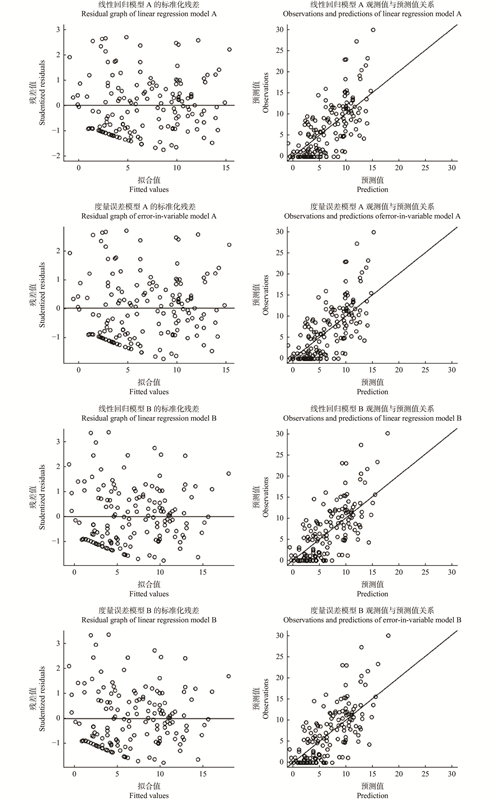
表4
基于设计、基于模型和基于模型辅助的估计值"
| 估计值 Estimates | 抽样设计 Sampling design | 遥感自变量 Independent variable ( | 遥感模型 Remote sensing model | 均值 Mean ( | 方差 Variance [ | 变异系数 Coefficient of variation(CV)(%) |
| 基于设计的估计值 Design-based estimates | 二阶抽样 Two-stage sampling | — | — | 6.774 | 0.965 | 14.502 |
| 基于模型的估计值 Model-based estimates | — | Landsat 8-A | 线性回归模型A Linear regression model A | 6.495 | 0.121 | — |
| 度量误差模型A Error-in-variable model A | 6.509 | 0.119 | — | |||
| Landsat 8-B | 线性回归模型B Linear regression model B | 6.516 | 0.114 | — | ||
| 度量误差模型B Error-in-variable model B | 6.551 | 0.112 | — | |||
| 基于模型辅助的估计值 Model-assisted estimates | 二阶抽样 Two-stage sampling | Landsat 8-A | 线性回归模型A Linear regression model A | 6.571 | 0.297 | 8.293 |
| 度量误差模型A Error-in-variable model A | 6.570 | 0.296 | 8.283 | |||
| Landsat 8-B | 线性回归模型B Linear regression model B | 6.591 | 0.261 | 7.743 | ||
| 度量误差模型B Error-in-variable model B | 6.590 | 0.259 | 7.724 |
表5
应用不同时间遥感数据的基于模型的估计值"
| 遥感自变量 Independent variable( | 线性回归模型A Linear regression model A | 度量误差模型A Error-in-variable model A | 线性回归模型B Linear regression model B | 度量误差模型B Error-in-variable model B | |||||||
| 均值 Mean ( | 方差Variance [ | 均值 Mean ( | 方差Variance [ | 均值 Mean ( | 方差Variance [ | 均值 Mean ( | 方差Variance [ | ||||
| Landsat 8-A | 6.495 | 0.121 | 6.509 | 0.119 | 9.920 | 0.280 | 9.984 | 0.276 | |||
| Landsat 8-B | 3.809 | 0.067 | 3.811 | 0.064 | 6.516 | 0.114 | 6.551 | 0.113 | |||
| Landsat 8-C | 2.492 | 0.067 | 2.489 | 0.064 | 4.847 | 0.067 | 4.868 | 0.066 | |||
| Landsat 8-D | 0.768 | 0.094 | 0.758 | 0.089 | 2.662 | 0.040 | 2.665 | 0.036 | |||
| Landsat 8-E | 0.464 | 0.102 | 0.452 | 0.096 | 2.276 | 0.040 | 2.276 | 0.035 | |||
| Landsat 8-F | ?0.305 | 0.126 | ?0.320 | 0.119 | 1.301 | 0.043 | 1.293 | 0.037 | |||
| Landsat 8-G | 1.452 | 0.079 | 1.445 | 0.075 | 3.529 | 0.046 | 3.539 | 0.044 | |||
| Landsat 8-H | ?0.287 | 0.125 | ?0.302 | 0.118 | 1.324 | 0.043 | 1.316 | 0.037 | |||
表6
应用不同时间遥感数据的基于模型辅助的估计值"
| 遥感自 变量 Independent variable ( | 线性回归模型A Linear regression model A | 度量误差模型A Error-in-variable model A | 线性回归模型B Linear regression model B | 度量误差模型B Error-in-variable model B | |||||||||||
| 均值 Mean ( | 方差 Variance [ | 变异系数 Coefficient of variation (CV)(%) | 均值 Mean ( | 方差 Variance [ | 变异系数 Coefficient of variation (CV)(%) | 均值 Mean ( | 方差 Variance [ | 变异系数 Coefficient of variation (CV)(%) | 均值 Mean ( | 方差 Variance [ | 变异系数 Coefficient of variation (CV)(%) | ||||
| Landsat 8-A | 6.571 | 0.297 | 8.293 | 6.570 | 0.296 | 8.283 | 6.517 | 0.279 | 8.099 | 6.514 | 0.279 | 8.112 | |||
| Landsat 8-B | 6.630 | 0.320 | 8.535 | 6.630 | 0.319 | 8.518 | 6.592 | 0.261 | 7.743 | 6.590 | 0.259 | 7.724 | |||
| Landsat 8-C | 6.649 | 0.393 | 9.424 | 6.648 | 0.391 | 9.405 | 6.616 | 0.306 | 8.360 | 6.614 | 0.303 | 8.323 | |||
| Landsat 8-D | 6.717 | 0.587 | 11.401 | 6.717 | 0.585 | 11.389 | 6.702 | 0.507 | 10.628 | 6.701 | 0.504 | 10.598 | |||
| Landsat 8-E | 6.617 | 0.557 | 11.274 | 6.616 | 0.555 | 11.261 | 6.575 | 0.473 | 10.455 | 6.573 | 0.469 | 10.423 | |||
| Landsat 8-F | 6.653 | 0.631 | 11.943 | 6.652 | 0.630 | 11.934 | 6.620 | 0.565 | 11.353 | 6.619 | 0.562 | 11.330 | |||
| Landsat 8-G | 6.606 | 0.474 | 10.426 | 6.605 | 0.473 | 10.415 | 6.561 | 0.412 | 9.784 | 6.559 | 0.410 | 9.763 | |||
| Landsat 8-H | 6.794 | 0.619 | 11.582 | 6.794 | 0.618 | 11.573 | 6.799 | 0.562 | 11.024 | 6.799 | 0.560 | 11.004 | |||
图3
基于模型的统计推断在各模型下对8个连续时间Landsat8数据集的响应"
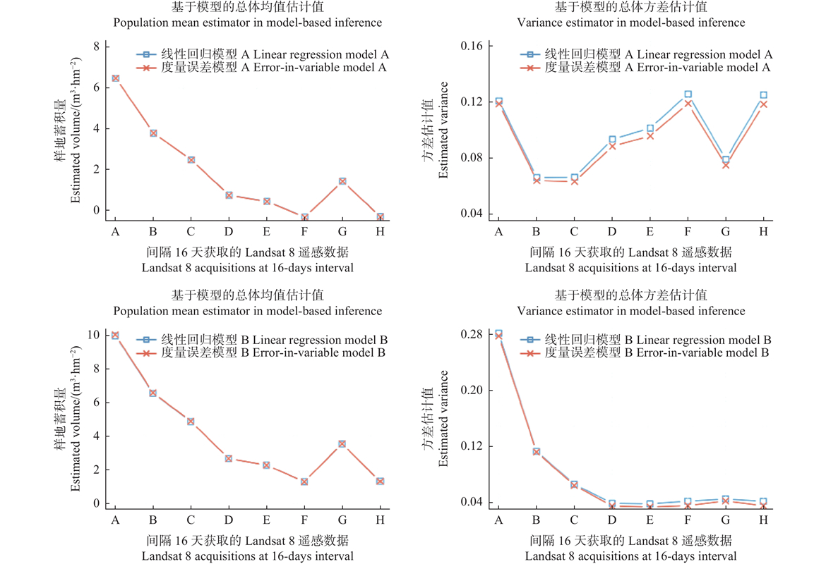

图4
基于模型辅助的统计推断在各模型下对8个连续时间Landsat8数据集的响应"
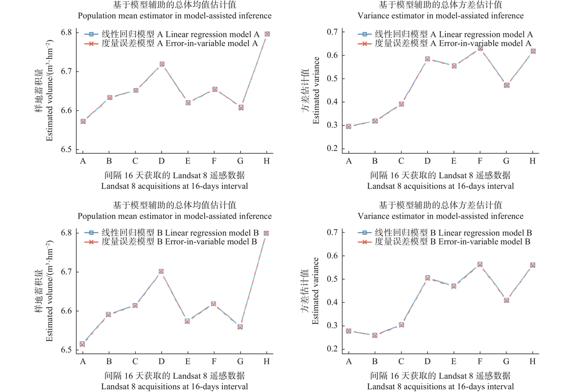

图5
基于模型辅助的统计推断在各模型下的变异系数估计量"
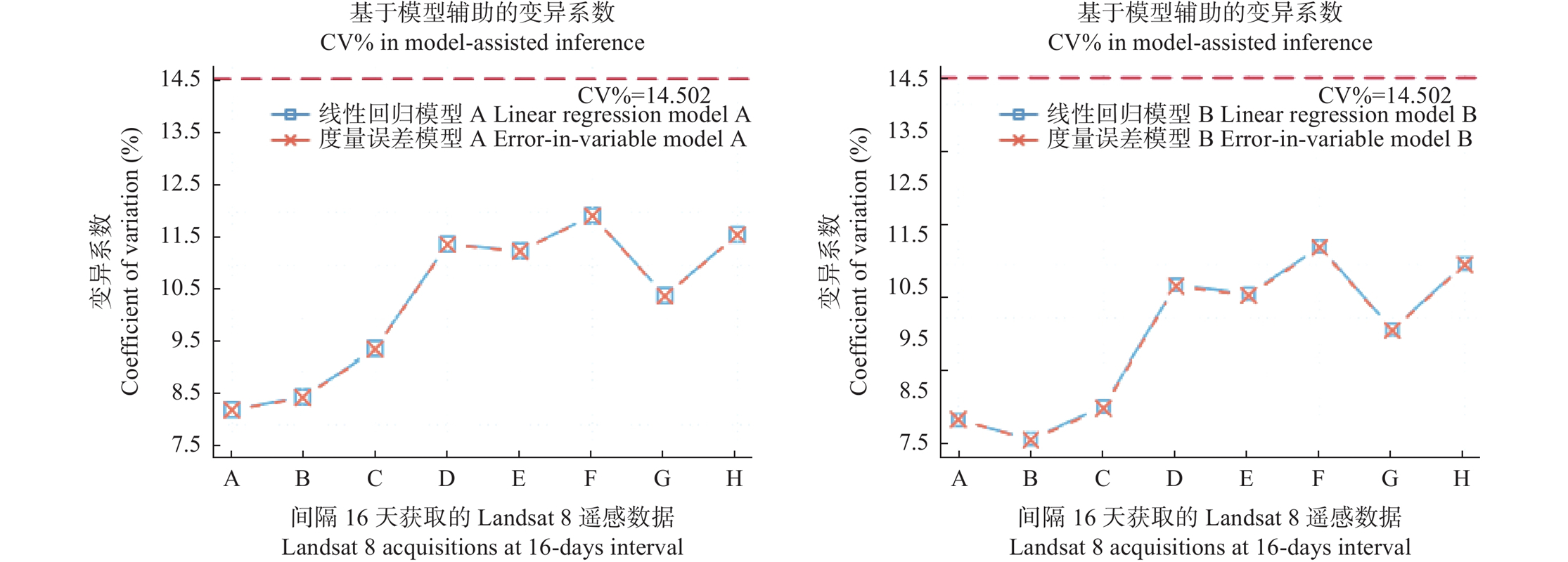
表7
不同样本量下应用Landsat 8-G和Landsat 8-H的模型辅助估计值"
| 模型Model | 遥感数据 Independent Variable ( | 重抽样次数 Number of repeated sampling | 20 | 40 | 60 | 80 | 100 | |||||
| 线性回归模型A Linear regression model A | Landsat 8-G | 6.597 | 1.245 | 6.608 | 0.618 | 6.610 | 0.413 | 6.613 | 0.310 | 6.604 | 0.247 | |
| 6.612 | 1.241 | 6.608 | 0.620 | 6.604 | 0.414 | 6.612 | 0.310 | 6.608 | 0.248 | |||
| Landsat 8-H | 6.788 | 1.484 | 6.795 | 0.736 | 6.799 | 0.492 | 6.803 | 0.369 | 6.792 | 0.295 | ||
| 6.803 | 1.479 | 6.798 | 0.739 | 6.790 | 0.492 | 6.800 | 0.369 | 6.796 | 0.295 | |||
| 度量误差模型A Error-in-variable model A | Landsat 8-G | 6.596 | 1.243 | 6.607 | 0.617 | 6.609 | 0.413 | 6.613 | 0.310 | 6.603 | 0.247 | |
| 6.611 | 1.239 | 6.608 | 0.619 | 6.603 | 0.413 | 6.611 | 0.309 | 6.607 | 0.247 | |||
| Landsat 8-H | 6.788 | 1.483 | 6.795 | 0.735 | 6.799 | 0.492 | 6.803 | 0.369 | 6.792 | 0.294 | ||
| 6.803 | 1.478 | 6.798 | 0.738 | 6.791 | 0.492 | 6.800 | 0.368 | 6.796 | 0.295 | |||
|
黄华国. 林业定量遥感研究进展和展望. 北京林业大学学报, 2019, 41 (12): 1- 14.
doi: 10.12171/j.1000-1522.20190326 |
|
|
Huang H G. Progress and perspective of quantitative remote sensing of forestry. Journal of Beijing Forestry University, 2019, 41 (12): 1- 14.
doi: 10.12171/j.1000-1522.20190326 |
|
| 李好奇. 2007. 度量误差模型参数估计及其统计性质. 长沙: 湖南大学. | |
| Li H Q. 2007. Parameter estimation of measurement error model and its statistical properties. Changsha: Hunan University. [in Chinese] | |
| 王雪军, 张煜星, 黄国胜, 等. 全国森林面积和森林蓄积年度出数方法探讨. 江西农业大学学报, 2016, 38 (1): 9- 18. | |
| Wang X J, Zhang Y X, Huang G S, et al. Discussion on methods for annual national producing estimates of forest area and forest stock in China. Acta Agriculturae Universitatis Jiangxiensis, 2016, 38 (1): 9- 18. | |
| 曾伟生. 遥感技术在森林资源清查中的应用问题探讨. 中南林业调查规划, 2004, 23 (1): 47- 49. | |
| Zeng W S. Discussion on application of remote sensing in forest inventories. Central South Forest Inventory and Planning, 2004, 23 (1): 47- 49. | |
| 曾伟生, 黄国胜, 党永峰, 等. 全国森林资源宏观监测的抽样设计与估计方法探索. 林业资源管理, 2016, (3): 1- 6. | |
| Zeng W S, Huang G S, Dang Y F, et al. Discussion on sampling design and estimation methods of national forest resources macro-monitoring. Forest Resources Management, 2016, (3): 1- 6. | |
| 曾伟生, 易善军, 蒲 莹. 森林资源调查监测年度数据产出方法研究. 中南林业调查规划, 2022, 41 (3): 1- 6,11. | |
| Zeng W S, Yi S J, Pu Y. Study on producing annual data in forest inventory and monitoring. Central South Forest Inventory and Planning, 2022, 41 (3): 1- 6,11. | |
| 郑冬梅, 智长贵, 黄国胜, 等. 遥感大样地点面判读方法在森林资源宏观监测中的应用分析. 林业资源管理, 2017, (6): 137- 142, 148. | |
| Zheng D M, Zhi C G, Huang G S, et al. Analysis of forest resources monitoring by zoning interpretation and point interpretation of remote sensing large plot. Forest Resources Management, 2017, (6): 137- 142, 148. | |
|
Akaike H. A new look at the statistical model identification. IEEE Transactions on Automatic Control, 1974, 19 (6): 716- 723.
doi: 10.1109/TAC.1974.1100705 |
|
|
Battauz M, Bellio R. Structural modeling of measurement error in generalized linear models with rasch measures as covariates. Psychometrika, 2011, 76 (1): 40- 56.
doi: 10.1007/s11336-010-9195-z |
|
|
Birth G S, McVey G R. Measuring the color of growing turf with a reflectance Spectrophotometer. Agronomy Journal, 1968, 60 (6): 640- 643.
doi: 10.2134/agronj1968.00021962006000060016x |
|
| Carroll R J, Ruppert D, Stefanski L A, et al. 2006. Measurement error in nonlinear models. New York: Chapman and Hall/CRC. | |
| Carroll R J, Ruppert D. 1988. Transformation and weighting in regression. New York: Chapman and Hall/CRC. | |
| Cassel C M, Särndal C E, Wretman J H. 1977. Foundations of inference in survey sampling. New York: John Wiley & Sons. | |
|
Chave J, Andalo C, Brown S, et al. Tree allometry and improved estimation of carbon stocks and balance in tropical forests. Oecologia, 2005, 145 (1): 87- 99.
doi: 10.1007/s00442-005-0100-x |
|
| Cochran W G. 1977. Sampling techniques. 3rd ed. NJ: John Wiley & Sons. | |
|
Cook J R, Stefanski L A. Simulation-extrapolation estimation in parametric measurement error models. Journal of the American Statistical Association, 1994, 89 (428): 1314- 1328.
doi: 10.1080/01621459.1994.10476871 |
|
| Curran P J, Hay A M. The importance of measurement error for certain procedures in remote sensing at optical wavelengths. Photogrammetric Engineering and Remote Sensing, 1986, 52, 229- 241. | |
|
Fischer C, Kleinn C, Fehrmann L, et al. A national level forest resource assessment for Burkina Faso–A field based forest inventory in a semiarid environment combining small sample size with large observation plots. Forest Ecology and Management, 2011, 262 (8): 1532- 1540.
doi: 10.1016/j.foreco.2011.07.001 |
|
|
Fu L Y, Liu Q W, Sun H, et al. Development of a system of compatible individual tree diameter and aboveground biomass prediction models using error-In-variable regression and airborne LiDAR data. Remote Sensing, 2018, 10 (2): 325.
doi: 10.3390/rs10020325 |
|
|
Fu L Y, Zeng W S, Tang S Z. Individual tree biomass models to estimate forest biomass for large spatial regions developed using four pine species in China. Forest Science, 2017, 63 (3): 241- 249.
doi: 10.5849/FS-2016-055 |
|
| Fuller W A. 2009. Sampling statistics. New York: John Wiley & Sons. | |
|
Ganse R A, Amemiya Y, Fuller W A. Prediction when both variables are subject to error, with application to earthquake magnitudes. Journal of the American Statistical Association, 1983, 78 (384): 761- 765.
doi: 10.1080/01621459.1983.10477016 |
|
|
Gao B C. NDWI: a normalized difference water index for remote sensing of vegetation liquid water from space. Remote Sensing of Environment, 1996, 58 (3): 257- 266.
doi: 10.1016/S0034-4257(96)00067-3 |
|
|
Gasparri N I, Parmuchi M G, Bono J, et al. Assessing multi-temporal Landsat 7 ETM+ images for estimating above-ground biomass in subtropical dry forests of Argentina. Journal of Arid Environments, 2010, 74 (10): 1262- 1270.
doi: 10.1016/j.jaridenv.2010.04.007 |
|
|
Goelz J C G, Burk T E. Development of a well-behaved site index equation: jack pine in north central Ontario. Canadian Journal of Forest Research, 1992, 22 (6): 776- 784.
doi: 10.1139/x92-106 |
|
|
Goelz J C G, Burk T E. Measurement error causes bias in site index equations. Canadian Journal of Forest Research, 1996, 26 (9): 1585- 1593.
doi: 10.1139/x26-178 |
|
|
Hansen M H, Madow W G, Tepping B J. An evaluation of model-dependent and probability-sampling inferences in sample surveys. Journal of the American Statistical Association, 1983, 78 (384): 776- 793.
doi: 10.1080/01621459.1983.10477018 |
|
| Haralick R M, Shanmugam K, Dinstein I. 1973. Textural features for image classification. IEEE Transactions on Systems, Man, and Cybernetics, SMC-3(6): 610-621. | |
| Harrell F E Jr. 2001. Regression modeling strategies: with applications to linear models, logistic regression, and survival analysis. New York, NY: Springer. | |
|
Hou Z Y, Xu Q, McRoberts R E, et al. Effects of temporally external auxiliary data on model-based inference. Remote Sensing of Environment, 2017, 198, 150- 159.
doi: 10.1016/j.rse.2017.06.013 |
|
|
Hou Z Y, Xu Q, Nuutinen T, et al. Extraction of remote sensing-based forest management units in tropical forests. Remote Sensing of Environment, 2013, 130, 1- 10.
doi: 10.1016/j.rse.2012.11.006 |
|
|
Hou Z Y, Xu Q, Tokola T. Use of ALS, Airborne CIR and ALOS AVNIR-2 data for estimating tropical forest attributes in Lao PDR. ISPRS Journal of Photogrammetry and Remote Sensing, 2011, 66 (6): 776- 786.
doi: 10.1016/j.isprsjprs.2011.09.005 |
|
| Huete A, Didan K, Miura T, et al. Overview of the radiometric and biophysical performance of the MODIS vegetation indices. Remote Sensing of Environment, 2002, 83 (1/2): 195- 213. | |
|
Jonsson K, Ong C K, Odongo J C W. Influence of scattered néré and karité trees on microclimate, soil fertility and millet yield in Burkina Faso. Experimental Agriculture, 1999, 35 (1): 39- 53.
doi: 10.1017/S0014479799001039 |
|
| Kangas A S. Effect of errors-in-variables on coefficients of a growth model and on prediction of growth. Forest Ecology and Management, 1998, 102 (2/3): 203- 212. | |
| Kangas A S, Maltamo M. 2006. Forest inventory: methodology and applications. Dordrecht: Springer, 179−194. | |
| Kvålseth T O. Cautionary note about R2. The American Statistician, 1985, 39, 279- 285. | |
| Lehmann E L, Casella G. 1998. Theory of point estimation. 2nd ed. New York: Springer. | |
|
Lindley D V. Regression lines and the linear functional relationship. Journal of the Royal Statistical Society Series B: Statistical Methodology, 1947, 9 (2): 218- 244.
doi: 10.2307/2984115 |
|
|
Lockwood J R, McCaffrey D F. Correcting for test score measurement error in ANCOVA models for estimating treatment effects. Journal of Educational and Behavioral Statistics, 2014, 39 (1): 22- 52.
doi: 10.3102/1076998613509405 |
|
| Lymburner L, Beggs P J, Jacobson C R. Estimation of canopy-average surface-specific leaf area using Landsat TM data. Photogrammetric Engineering and Remote Sensing, 2000, 66 (2): 183- 191. | |
|
McRoberts R E, Næsset E, Gobakken T. The effects of temporal differences between map and ground data on map-assisted estimates of forest area and biomass. Annals of Forest Science, 2016a, 73 (4): 839- 847.
doi: 10.1007/s13595-015-0485-6 |
|
|
McRoberts R E, Chen Q, Domke G M, et al. Hybrid estimators for mean aboveground carbon per unit area. Forest Ecology and Management, 2016b, 378, 44- 56.
doi: 10.1016/j.foreco.2016.07.007 |
|
|
McRoberts R E, Chen Q, Walters B F, et al. The effects of global positioning system receiver accuracy on airborne laser scanning-assisted estimates of aboveground biomass. Remote Sensing of Environment, 2018a, 207, 42- 49.
doi: 10.1016/j.rse.2017.09.036 |
|
|
McRoberts R E, Chen Q, Gormanson D D, et al. The shelf-life of airborne laser scanning data for enhancing forest inventory inferences. Remote Sensing of Environment, 2018b, 206, 254- 259.
doi: 10.1016/j.rse.2017.12.017 |
|
|
McRoberts R E, Tomppo E O, Næsset E. Advances and emerging issues in national forest inventories. Scandinavian Journal of Forest Research, 2010, 25 (4): 368- 381.
doi: 10.1080/02827581.2010.496739 |
|
|
McRoberts R E, Tomppo E O, Vibrans A C, et al. Design considerations for tropical forest inventories. Pesquisa Florestal Brasileira, 2013, 33 (74): 189- 202.
doi: 10.4336/2013.pfb.33.74.430 |
|
|
Næsset E, Gobakken T, Solberg S, et al. Model-assisted regional forest biomass estimation using LiDAR and InSAR as auxiliary data: a case study from a boreal forest area. Remote Sensing of Environment, 2011, 115 (12): 3599- 3614.
doi: 10.1016/j.rse.2011.08.021 |
|
| Nicholson S E. A revised picture of the structure of the “monsoon” and land ITCZ over west Africa. Climate Dynamics, 2009, 32 (7): 1155- 1171. | |
|
Peel M C, Finlayson B L, McMahon T A. Updated world map of the Köppen-Geiger climate classification. Hydrology and Earth System Sciences, 2007, 11 (5): 1633- 1644.
doi: 10.5194/hess-11-1633-2007 |
|
| Rizopoulos D. 2009. Bootstrap stepAIC. https://CRAN.R-project.org/package= bootStepAIC (accessed 22.10.1). | |
| Rouse J W, Haas R H, Schell J A, et al. 1973. Monitoring vegetation systems in the great plains with ERST. Third ERTS Symposium, NASA SP-351, 309–317. | |
|
Royall R M, Herson J. Robust estimation in finite populations II: stratification on a size variable. Journal of the American Statistical Association, 1973, 68 (344): 890.
doi: 10.1080/01621459.1973.10481441 |
|
|
Saarela S, Schnell S, Tuominen S, et al. Effects of positional errors in model-assisted and model-based estimation of growing stock volume. Remote Sensing of Environment, 2016, 172, 101- 108.
doi: 10.1016/j.rse.2015.11.002 |
|
| Särndal C E, Swensson B, Wretman J. 1992. Model assisted survey sampling. New York, NY: Springer, 323. | |
| Särndal C E, Thomsen I, Hoem J M, et al. Design-based and model-based inference in survey sampling with discussion and reply. Scandinavian Journal of Statistics, 1978, 5 (1): 27- 52. | |
|
Sawadogo L, Nygård R, Pallo F. Effects of livestock and prescribed fireon coppice growth after selective cutting of Sudanian savannah in Burkina Faso. Annals of Forest Science, 2002, 59 (2): 185- 195.
doi: 10.1051/forest:2002005 |
|
| Tomppo E, Gschwantner T, Lawrence M, et al. 2010. National forest inventories. pathways for common reporting. Dordrecht: Springer. | |
| Vågen T G, Winowiecki L A, Tamene Desta L, et al. 2015. The land degradation surveillance framework (LDSF) - Field Guide v 4.1. Nairobi: World Agroforestry Centre. | |
| Valliant R, Dorfman A, Royall R. 2000. Finite population sampling and inference: a prediction approach. New York: John Wiley & Sons. | |
| Willett J B, Singer J D. Another cautionary note about R2: its use in weighted least-squares regression analysis. The American Statistician, 1988, 42 (3): 236. | |
|
Wu W C, de Pauw E, Helldén U. Assessing woody biomass in African tropical savannahs by multiscale remote sensing. International Journal of Remote Sensing, 2013, 34 (13): 4525- 4549.
doi: 10.1080/01431161.2013.777487 |
|
|
Zhang W H, Ke Y H, Quackenbush L J, et al. Using error-in-variable regression to predict tree diameter and crown width from remotely sensed imagery. Canadian Journal of Forest Research, 2010, 40 (6): 1095- 1108.
doi: 10.1139/X10-073 |
| [1] | 李贾,兰岚,张佐忠,袁文涛,高德民,宗树琴,业巧林. 基于深度学习的森林可燃物含水率反演技术[J]. 林业科学, 2022, 58(10): 47-58. |
| [2] | 潘颖,丁鸣鸣,林杰,代侨,郭赓,崔琳琳. 基于PROSAIL模型和多角度遥感数据的森林叶面积指数反演[J]. 林业科学, 2021, 57(4): 90-106. |
| [3] | 李春干,李振. 机载激光雷达大区域亚热带森林参数估测的普适性模型式[J]. 林业科学, 2021, 57(10): 23-35. |
| [4] | 李丹, 张俊杰, 赵梦溪. 基于FCM和分水岭算法的无人机影像中林分因子提取[J]. 林业科学, 2019, 55(5): 180-187. |
| [5] | 刘鲁霞, 庞勇, 任海保, 李增元. 基于高分2号遥感数据估测中亚热带天然林木本植物物种多样性[J]. 林业科学, 2019, 55(2): 61-74. |
| [6] | 邱霓, 徐颂军, 邱彭华, 杨文槐, 杨秀, 杨倩. 珠海淇澳岛红树林群落分布与景观格局[J]. 林业科学, 2019, 55(1): 1-10. |
| [7] | 李晓红, 陈尔学, 李增元, 李世明. 综合应用多源遥感数据的面向对象土地覆盖分类方法[J]. 林业科学, 2018, 54(2): 68-80. |
| [8] | 祖笑锋, 覃先林, 李增元, 孙桂芬, 刘树超. 基于幂律分布的森林燃烧生物量卫星遥感估测方法[J]. 林业科学, 2017, 53(10): 90-99. |
| [9] | 徐小军;周国模;杜华强;董德进;崔瑞蕊;周宇峰;沈振明. 基于Landsat TM数据估算雷竹林地上生物量[J]. 林业科学, 2011, 47(9): 1-6. |
| [10] | 刘鹏举 黄水生 谢阳生 侯瑞霞 唐小明. 基于边界锁定的二类调查方法研究[J]. , 2006, 42(zk): 51-55. |
| [11] | 谭炳香 杜纪山. 遥感数据分析林区的植被和土壤侵蚀特征[J]. 林业科学, 2006, 42(4): 7-11. |
| 阅读次数 | ||||||
|
全文 |
|
|||||
|
摘要 |
|
|||||