
林业科学 ›› 2021, Vol. 57 ›› Issue (4): 90-106.doi: 10.11707/j.1001-7488.20210410
潘颖1,2,丁鸣鸣3,林杰1,*,代侨1,郭赓1,崔琳琳1
收稿日期:2019-06-18
出版日期:2021-04-25
发布日期:2021-05-21
通讯作者:
林杰
基金资助:Ying Pan1,2,Mingming Ding3,Jie Lin1,*,Qiao Dai1,Geng Guo1,Linlin Cui1
Received:2019-06-18
Online:2021-04-25
Published:2021-05-21
Contact:
Jie Lin
摘要:
目的: 基于多角度PROBA/CHRIS遥感数据和野外实测数据,结合PROSAIL模型和随机森林模型反演森林叶面积指数(LAI),以提高植被LAI遥感反演精度,为区域土壤侵蚀遥感定量监测提供新的方法和模型。方法: 以南京市紫金山和幕府山为研究区,采用野外调查、遥感影像、辐射传输模型与数学模型相结合的方法,构建基于PROSAIL模型和多角度PROBA/CHRIS遥感数据的随机森林LAI反演模型,对PROSAIL模型进行敏感性分析和适用性评价,确定最佳LAI反演模型,并利用地面实测LAI进行精度验证和评价。结果: PROSAIL模型中各输入参数敏感性大小为LAI>叶绿素a、b含量Cab>叶片干物质含量Cm>热点参数SL>叶片内部结构参数N>等效水厚度Cw;模拟的冠层反射率精度大小为0°>36°>-36°>55°>-55°。单角度LAI反演模型中,前向观测角55°精度最高,其决定系数(R2)、均方根误差(RMSE)和平均绝对百分误差(MAPE)分别为0.915 7、0.235 7和0.042 6;相比于传统垂直观测,55°模型的R2提高0.75%,RMSE和MAPE分别降低3.76%和5.12%;相比于非线性回归模型,单角度随机森林LAI反演模型的R2提高0.7%,RMSE和MAPE分别降低15.40%和11.98%;单角度LAI反演模型精度由高到低依次为55°、36°、0°、-55°、-36°。多角度LAI反演模型中,3角度组合(0°、36°、55°)LAI反演精度最高,其R2、RMSE和MAPE分别为0.918 4、0.231 9和0.041 5,相比于单角度55°,R2提高0.29%,RMSE和MAPE分别降低1.61%和2.58%;相比于传统垂直观测,3角度组合模型的R2提高1.05%,RMSE和MAPE分别降低5.31%和7.57%;相比于非线性回归模型,多角度随机森林LAI反演模型的R2提高0.79%,RMSE和MAPE分别降低6.72%和9.19%。紫金山西部区域LAI介于0.44~6.70之间,林地LAI均值为3.04;紫金山西部林地LAI整体上呈北部和南部高、中间低的空间分布格局。结论: 最佳LAI反演模型为基于3角度组合(0°、36°、55°)的随机森林LAI反演模型;一方面,增加观测角度可提供更多植被冠层结构信息,LAI反演精度随观测角度增加而增加,但另一方面,观测角度过多会使像元空间重采样、叶片阴影和土壤阴影等问题带来更多不确定性,LAI反演精度反而下降;无论是单角度还是多角度数据,随机森林LAI反演模型精度均高于非线性回归模型,随机森林模型能够明显提高LAI反演精度,适用于区域植被LAI反演;多角度遥感数据能够反映森林立体结构信息和地物多维空间结构特征,显著改善传统垂直观测数据反演LAI精度较低的问题,从而有效提高植被LAI反演精度。
中图分类号:
潘颖,丁鸣鸣,林杰,代侨,郭赓,崔琳琳. 基于PROSAIL模型和多角度遥感数据的森林叶面积指数反演[J]. 林业科学, 2021, 57(4): 90-106.
Ying Pan,Mingming Ding,Jie Lin,Qiao Dai,Geng Guo,Linlin Cui. Inversion of Forest Leaf Area Index Based on PROSAIL Model and Multi-Angle Remote Sensing Data[J]. Scientia Silvae Sinicae, 2021, 57(4): 90-106.
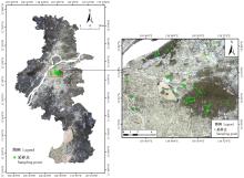
图1
采样点分布"

表1
采样点不同植被类型的LAI描述统计"
| 植被类型 Vegetation types | 样点数 Sample number | 最小值 Min. | 最大值 Max. | 平均值 Mean | 偏度 Skewness | 峰度 Kurtosis | 变异系数 Coefficient of variation (%) |
| 阔叶林 Broadleaf forest | 59 | 1.70 | 6.30 | 3.90 | -0.08 | 0.77 | 24.36 |
| 针叶林 Coniferous forest | 18 | 2.28 | 4.61 | 3.62 | -0.38 | -0.74 | 20.58 |
| 针阔混交林 Coniferous-broadleaf forest | 37 | 2.82 | 6.70 | 4.06 | 0.85 | 0.92 | 22.48 |
| 全样本 Full sample | 114 | 1.70 | 6.70 | 3.91 | 0.23 | 0.84 | 23.36 |
表2
多角度遥感数据源"
| 数据类型 Data type | 成像时间 Imaging time | 波谱范围 Band range | 分辨率 Resolution ratio |
| PROBA/CHRIS | 2015-09-07 | 0.4~1.1 | 17 |
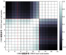
图2
CHRIS影像波段间的相关系数矩阵"
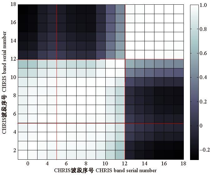
表3
敏感性分析参数设置①"
| 参数设置 Parameter setting | 分析参数 Analysis parameters | |||||
| LAI | N | Cab | Cw | Cm | SL | |
| LAI | 1-0.5-7 | 3.8 | 3.8 | 3.8 | 3.8 | 3.8 |
| N | 1.50 | 1-0.1-2.5 | 1.50 | 1.50 | 1.50 | 1.50 |
| Cab | 44.72 | 44.72 | 20-5-70 | 44.72 | 44.72 | 44.72 |
| Cw | 0.015 3 | 0.015 3 | 0.015 3 | 0.006-0.02-0.06 | 0.015 3 | 0.015 3 |
| Cm | 0.008 3 | 0.008 3 | 0.008 3 | 0.008 3 | 0.004-0.002-0.04 | 0.008 3 |
| SL | 0.15 | 0.15 | 0.15 | 0.15 | 0.15 | 0.01-0.05-0.31 |
| θs | 61.88 | 61.88 | 61.88 | 61.88 | 61.88 | 61.88 |
| θv | 20.18 | 20.18 | 20.18 | 20.18 | 20.18 | 20.18 |
| φ | 214.36 | 214.36 | 214.36 | 214.36 | 214.36 | 214.36 |
表4
植被指数及其表达式①"
| 植被指数 Vegetation indices | 表达式 Expressions | 参考文献 References |
| 比值植被指数 Ratio vegetation index(RVI) | ρNIR/ρRED | |
| 归一化植被指数Normalized difference vegetation index(NDVI) | (ρNIR-ρRED)/(ρNIR+ρRED) | |
| 垂直植被指数 Perpendicular vegetation index(PVI) | ||
| 差值植被指数 Difference vegetation index(DVI) | ρNIR-ρRED | |
| 土壤调节植被指数 Soil adjusted vegetation index(SAVI) | 1.5(ρNIR-ρRED)/(ρNIR+ρRED+0.5) | |
| 增强型植被指数 Enhanced vegetation index(EVI) | 2.5(ρNIR-ρRED)/(ρNIR+6.0ρRED-7.5ρBLUE+1) | |
| 修正土壤调节植被指数 Modified soil adjusted vegetation index(MSAVI) | ||
| 结构不敏感色素(植被)指数 Structure insensitive pigment (vegetation) index(SIPI) | (ρNIR-ρBLUE)/(ρNIR+ρBLUE) |

图3
LAI反演技术路线"
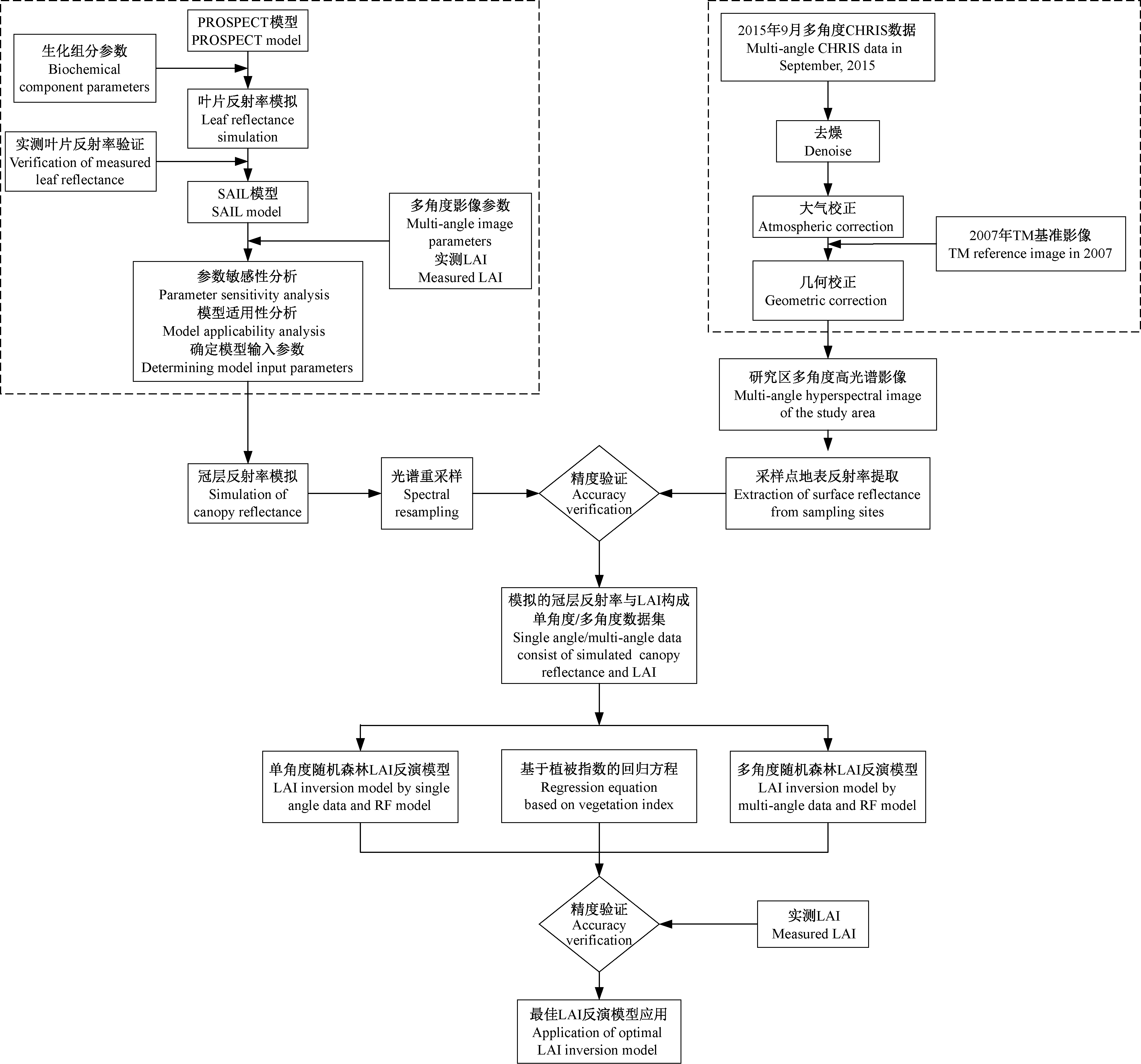
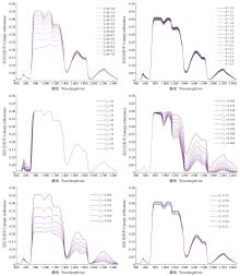
图4
冠层反射率随模型参数变化曲线"

表5
PROSAIL模型各参数敏感度计算结果"
| 等级 Level | LAI | N | Cab | Cm | Cw | SL |
| 1 | 0.332 86 | 0.021 60 | 0.261 82 | 0.068 09 | 0.011 88 | 0.023 62 |
| 2 | 0.227 62 | 0.026 81 | 0.085 11 | 0.058 56 | 0.011 42 | 0.021 18 |
| 3 | 0.161 23 | 0.039 96 | 0.034 61 | 0.051 89 | 0.011 00 | 0.017 98 |
| 4 | 0.121 63 | 0.047 22 | 0.023 76 | 0.046 93 | 0.010 61 | 0.015 47 |
| 5 | 0.096 81 | 0.050 54 | 0.016 87 | 0.043 08 | 0.010 26 | 0.013 49 |
| 平均值 Mean | 0.188 03 | 0.037 23 | 0.084 43 | 0.053 71 | 0.011 03 | 0.018 35 |
表6
PROSAIL模型变化输入参数和范围"
| 变化参数 Variable parameters | 参数描述 Parametric description | 参数值 Parameter values | ||
| 最小值 Min. | 最大值 Max. | 步长 Step | ||
| LAI | 叶面积指数 Leaf area index | 0.5 | 6.5 | 0.02 |
| Cab/(μg·cm-2) | 叶片叶绿素a、b含量 Chlorophyll a and b content | 20 | 70 | 5 |
| θv/(°) | 观测天顶角 Observation zenith angle | 20.18,39.47,37.27,57.65,56.04 | ||
| φ | 太阳-卫星相对方位角 Sun-satellite relative azimuth angle | 214.36,111.77,243.56,103.82,246.91 | ||
表7
PROSAIL模型常量输入参数"
| 常量参数 Constant parameters | 参数描述 Parametric description | 参数值 Parameter values |
| Cw/cm | 叶片等效水厚度 Leaf equivalent water thickness | 0.015 3 |
| Cm/(g·cm-2) | 叶片干物质含量 Leaf dry matter content | 0.008 3 |
| N | 叶片结构参数 Leaf structure parameter | 1.5 |
| θs | 太阳天顶角 Sun zenith angle | 61.88 |
| SL | 热点效应参数 Hot spot effect parameter | 0.15 |
| ALA | 平均叶倾角 Average leaf inclination angle | Spherical |
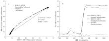
图5
PROSPECT模型模拟叶片反射率与实测叶片反射率"

表8
各角度模拟冠层反射率与影像反射率的精度评价"
| 指标 Index | -55° | -36° | 0° | 36° | 55° |
| RMSE | 0.127 2 | 0.065 2 | 0.047 3 | 0.054 7 | 0.091 3 |
| MAPE | 0.654 7 | 0.412 5 | 0.376 1 | 0.393 7 | 0.421 7 |
表9
实测LAI与不同观测角度下植被指数之间的相关性分析结果①"
| 植被指数 Vegetation indices | -55° | -36° | 0° | 36° | 55° |
| RVI | 0.191 7 | 0.300 3* | 0.362 2** | 0.287 5** | 0.179 6** |
| NDVI | 0.162 7 | 0.265 5* | 0.327 4** | 0.253 3** | 0.149 9 |
| PVI | 0.903 5** | 0.900 4** | 0.907 6** | 0.900 0** | 0.892 1** |
| DVI | 0.871 1** | 0.883 8** | 0.894 0** | 0.882 6** | 0.862 5** |
| SAVI | 0.760 1** | 0.827 1** | 0.848 8** | 0.821 9** | 0.753 3** |
| EVI | 0.809 6** | 0.852 3** | 0.867 9** | 0.848 9** | 0.803 3** |
| MSAVI | 0.735 5** | 0.832 5** | 0.859 2** | 0.824 7** | 0.721 9** |
| SIPI | 0.567 6** | 0.708 6** | 0.748 7** | 0.699 5** | 0.558 0** |
表10
LAI反演模型构建的角度组合方式"
| 角度数目 Angle number | 组合数 Combination number | 角度组合形式 Angle combination forms |
| 单角度 Single angle | 5 | 0°,36°,-36°,55°,-55° |
| 2角度 Two angles | 10 | (0°,36°),(0°,-36°),(0°,55°),(0°,-55°),(36°,-36°),(36°,55°),(36°,-55°),(-36°,55°),(-36°,-55°),(55°,-55°) |
| 3角度 Three angles | 10 | (0°,36°,-36°),(0°,36°,55°),(0°,36°,-55°),(0°,-36°,55°),(0°,-36°,-55°),(0°,55°,-55°),(36°,-36°,55°),(36°,-36°,-55°),(36°,55°,-55°),(-36°,55°,-55°) |
| 4角度 Four angles | 5 | (0°,36°,-36°,55°),(0°,36°,-36°,-55°),(0°,36°,55°,-55°),(0°,-36°,55°,-55°),(36°,-36°,55°,-55°) |
| 5角度 Five angles | 1 | (0°,36°,-36°,55°,-55°) |
表11
基于单角度数据的随机森林LAI反演模型精度"
| 观测角度 Observation angle | R2 | RMSE | MAPE |
| -55° | 0.908 3 | 0.245 8 | 0.046 1 |
| -36° | 0.641 1 | 0.486 2 | 0.060 1 |
| 0° | 0.908 9 | 0.244 9 | 0.044 9 |
| 36° | 0.909 9 | 0.243 6 | 0.043 7 |
| 55° | 0.915 7 | 0.235 7 | 0.042 6 |
表12
基于多角度数据的随机森林反演模型精度"
| 角度数目 Angle number | 观测角度组合 Observation angle combination | R2 | RMSE | MAPE |
| 2角度 Two angles | 0°,55° | 0.917 6 | 0.233 0 | 0.042 3 |
| 3角度 Three angles | 0°,36°,55° | 0.918 4 | 0.231 9 | 0.041 5 |
| 4角度 Four angles | 0°,36°,55°,-55° | 0.917 7 | 0.232 9 | 0.041 6 |
| 5角度 Five angles | 0°,36°,-36°,55°,-55° | 0.914 3 | 0.237 6 | 0.043 4 |
表13
基于单角度和多角度数据的非线性回归模型反演精度最高的组合汇总"
| 角度数目 Angle number | 观测角度/角度组合 Observation angle/angle combination | 模型 Models | R2 | RMSE | MAPE |
| 单角度 Single angle | 55° | y = 0.053 9exp(7.875 0PVI) | 0.909 3 | 0.278 6 | 0.048 4 |
| 2角度 Two angles | 0°,36° | y = 0.028 7exp(5.713 1PVI) | 0.910 6 | 0.267 8 | 0.047 4 |
| 3角度 Three angles | 0°,36°,55° | y = 0.045 2exp(8.297 7PVI) | 0.911 2 | 0.248 6 | 0.045 7 |
| 4角度 Four angles | 0°,36°,36°,-55° | y = 0.031 5exp(4.246 4PVI) | 0.904 8 | 0.280 4 | 0.049 0 |
| 5角度 Five angles | 0°,36°,-36°,55°,-55° | y = 0.027 1exp(3.376 0PVI) | 0.901 8 | 0.284 5 | 0.051 3 |
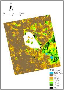
图6
基于PROBA/CHRIS遥感数据的0°、36°和55°融合反演得到的LAI分布"


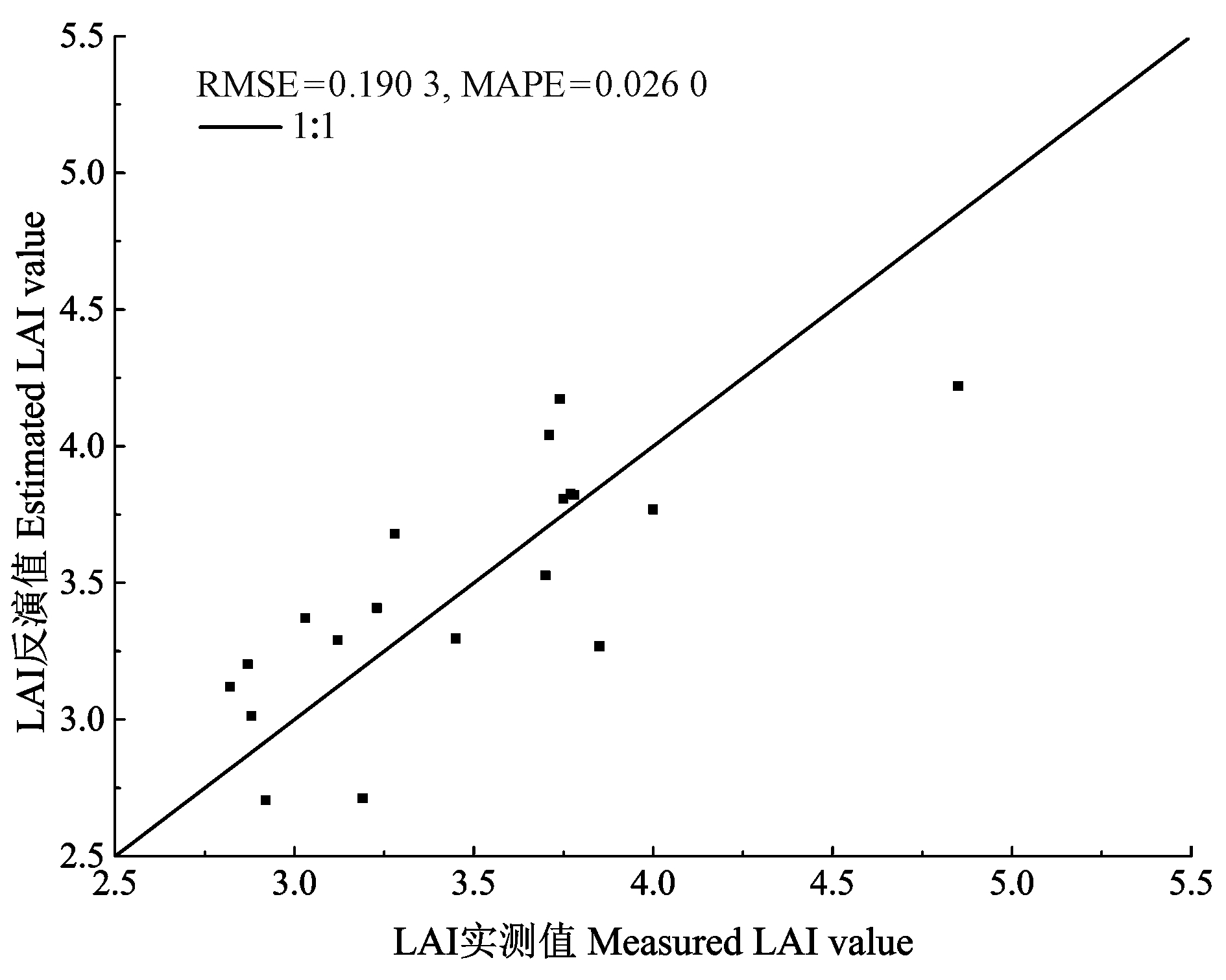
图7
LAI反演值与实测值的关系"
|
蔡博峰, 绍霞. 基于PROSPECT+SAIL模型的遥感叶面积指数反演. 国土资源遥感, 2007, 72 (2): 39- 43.
doi: 10.3969/j.issn.1001-070X.2007.02.010 |
|
|
Cai B F , Shao X . Remote sensing leaf area index inversion based on PROSPECT+SAIL model. Remote Sensing for Land and Resources, 2007, 72 (2): 39- 43.
doi: 10.3969/j.issn.1001-070X.2007.02.010 |
|
|
曹建军, 顾祝军, 徐建华, 等. 基于CHRIS/PROBA的植被叶面积指数估算模型研究. 安徽农业科学, 2013, 41 (2): 907- 910.
doi: 10.3969/j.issn.0517-6611.2013.02.156 |
|
|
Cao J J , Gu Z J , Xu J H , et al. Estimation models of leaf area index (LAI) based on remote sensing image of CHRIS/PROBA. Journal of Anhui Agriculture Science, 2013, 41 (2): 907- 910.
doi: 10.3969/j.issn.0517-6611.2013.02.156 |
|
| 陈添兴. 2012. 南京紫金山大型菌物多样性研究. 南京: 南京师范大学硕士学位论文. | |
| Chen T X. 2012. Study on the diversity of large bacteria in Mt. Zijin of Nanjing city. Nanjing: MS thesis of Nanjing Normal University. [in Chinese] | |
| 杜育璋, 姜小光, 张雨泽, 等. 基于Landsat-8遥感数据和PROSAIL辐射传输模型反演叶面积指数. 干旱区地理, 2016, 39 (5): 1096- 1103. | |
| Du Y Z , Jiang X G , Zhang Y Z , et al. Retrieving leaf area index using PROSAIL radiative transfer model based on Landsat-8 image. Arid Land Geography, 2016, 39 (5): 1096- 1103. | |
| 谷成燕, 杜华强, 周国模, 等. 基于PROSAIL辐射传输模型的毛竹林叶面积指数遥感反演. 应用生态学报, 2013, 24 (8): 2248- 2256. | |
| Gu C Y , Du H Q , Zhou G M , et al. Retrieval of leaf area index of moso bamboo forest with Landsat Thematic Mapper image based on PROSAIL canopy radiative transfer model. Chinese Journal of Applied Ecology, 2013, 24 (8): 2248- 2256. | |
| 韩兆迎, 朱西存, 房贤一, 等. 基于SVM与RF的苹果树冠LAI高光谱估测. 光谱学与光谱分析, 2016, 36 (3): 800- 805. | |
| Han Z Y , Zhu X C , Fang X Y , et al. Hyperspectral estimation of apple crown LAI based on SVM and RF. Spectroscopy and Spectral Analysis, 2016, 36 (3): 800- 805. | |
| 李粉玲, 王力, 刘京, 等. 基于高分一号卫星数据的冬小麦叶片SPAD值遥感估算. 农业机械学报, 2015, 46 (9): 273- 281. | |
| Li F L , Wang L , Liu J , et al. Remote sensing estimation of SPAD value for wheat leaf based on GF-1 data. Journal of Agricultural Machinery, 2015, 46 (9): 273- 281. | |
| 李林. 2004. 南京幕府山植物区系及其野生观赏植物资源应用研究. 南京: 南京林业大学硕士学位论文. | |
| Li L. 2004. Studies on flora of Mt. Mufu, Nanjing and the application of the wild ornamental plant resources. Nanjing: MS thesis of Nanjing Forestry University. [in Chinese] | |
| 李新辉, 宋小宁, 冷佩. 利用CHRIS/PROBA数据定量反演草地LAI方法研究. 国土资源遥感, 2011, 90 (3): 61- 66. | |
| Li X H , Song X N , Leng P . A quantitative method for grassland LAI inversion based on CHRIS/PROBA data. Remote Sensing for Land and Resources, 2011, 90 (3): 61- 66. | |
|
李映雪, 朱艳, 戴廷波, 等. 小麦叶面积指数与冠层反射光谱的定量关系. 应用生态学报, 2006, 17 (8): 1443- 1447.
doi: 10.3321/j.issn:1001-9332.2006.08.017 |
|
|
Li Y X , Zhu Y , Dai T B , et al. Quantitative relationship between leaf area index and canopy reflectance spectrum in wheat. Journal of Applied Ecology, 2006, 17 (8): 1443- 1447.
doi: 10.3321/j.issn:1001-9332.2006.08.017 |
|
|
林文鹏, 赵敏, 张翼飞, 等. 基于SPOT5遥感影像的城市森林叶面积指数反演. 测绘科学, 2008, 33 (2): 57- 59.
doi: 10.3771/j.issn.1009-2307.2008.02.020 |
|
|
Lin W P , Zhao M , Zhang Y F , et al. Study on estimation of urban forest LAI model based on SPOT5. Science of Surveying and Mapping, 2008, 33 (2): 57- 59.
doi: 10.3771/j.issn.1009-2307.2008.02.020 |
|
| 刘国华. 2004. 南京幕府山构树种群生态学及矿区废弃地植被恢复技术研究. 南京: 南京林业大学博士学位论文. | |
| Liu G H. 2004. Studies on flora of Mt. Mufu, Nanjing and the application of the wild ornamental plant resources. Nanjing: PhD thesis of Nanjing Forestry University. [in Chinese] | |
| 刘天凤. 2014. 基于PROSAIL模型的干旱半干旱地区LAI遥感反演建模. 兰州: 兰州大学硕士学位论文. | |
| Liu T F. 2014. Remote sensing modeling of leaf area index in arid and semi-arid region based on PROSAIL model. Lanzhou: MS thesis of Lanzhou University. [in Chinese] | |
| 柳艺博, 居为民, 陈镜明, 等. 2000~2010年中国森林叶面积指数时空变化特征. 科学通报, 2012, 57 (16): 1435- 1445. | |
| Liu Y B , Ju W M , Chen J M , et al. Temporal and spatial variation characteristics of forest leaf area index in China from 2000 to 2010. Science China Press, 2012, 57 (16): 1435- 1445. | |
| 吕杰. 2012. 基于机器学习和辐射传输模型的农作物叶绿素含量高光谱反演模型. 北京: 中国地质大学博士学位论文. | |
| Lü J. 2012. Hyperspectral remote sensing inversion model of crop chlorophyll content based on machine learning and radiative transfer models. Beijing: PhD thesis of China University of Geosciences. [in Chinese] | |
| 石锋. 2012. 基于HJ-1B星影像和PROSAIL模型相思树LAI反演. 福州: 福建师范大学硕士学位论文. | |
| Shi F. 2012. LAI inversion of A. richii based on HJ-1B satellite imagery data and PROSAIL model. Fuzhou: MS thesis of Fujian Normal University. [in Chinese] | |
|
宋开山, 张柏, 王宗明, 等. 基于人工神经网络的大豆叶面积高光谱反演研究. 中国农业科学, 2006, 39 (6): 1138- 1145.
doi: 10.3321/j.issn:0578-1752.2006.06.007 |
|
|
Song K S , Zhang B , Wang Z M , et al. Study on hyperspectral inversion of soybean leaf area based on artificial neural network. Chinese Agricultural Science, 2006, 39 (6): 1138- 1145.
doi: 10.3321/j.issn:0578-1752.2006.06.007 |
|
| 王春. 2009. 南京紫金山植物区系与植物资源研究. 南京: 南京林业大学硕士学位论文. | |
| Wang C. 2009. Studies on flora of Mt. Zijin vascular plants and studies of wild resource plants. Nanjing: MS thesis of Nanjing Forestry University. [in Chinese] | |
| 王李娟, 牛铮. PROSAIL模型的参数敏感性研究. 遥感技术与应用, 2014, 29 (2): 219- 223. | |
| Wang L J , Niu Z . Sensitivity analysis of vegetation parameters based on PROSAIL model. Remote Sensing Technology and Application, 2014, 29 (2): 219- 223. | |
| 吴伶, 刘湘南, 周博天, 等. 利用PROSPECT+SAIL模型反演植物生化参数的植被指数优化模拟. 应用生态学报, 2012, 23 (12): 3250- 3256. | |
| Wu L , Liu X N , Zhou B T , et al. Simulation of vegetation indices optimizing under retrieval of vegetation biochemical parameters based on PROSPECT + SAIL model. Chinese Journal of Applied Ecology, 2012, 23 (12): 3250- 3256. | |
| 吴志明, 李建超, 王睿, 等. 基于随机森林的内陆湖泊水体有色可溶性有机物(CDOM)浓度遥感估算. 湖泊科学, 2018, 30 (4): 979- 991. | |
| Wu Z M , Li J C , Wang R , et al. Estimation of CDOM concentration in inland lake based on random forest using Sentine-3A OLCI. Journal of Lake Sciences, 2018, 30 (4): 979- 991. | |
| 邢著荣. 2010. 基于辐射传输模型和CHRIS数据反演春小麦LAI. 青岛: 山东科技大学硕士学位论文. | |
| Xing Z R. 2010. Inversion of leaf area index of spring wheat based on radiative transfer model and CHRIS data. Qingdao: MS thesis of Shandong University of Science and Technology. [in Chinese] | |
| 杨福芹, 冯海宽, 李振海, 等. 基于赤池信息量准则的冬小麦叶面积指数高光谱估测. 农业工程学报, 2016, 32 (3): 163- 168. | |
| Yang F Q , Feng H K , Li Z H , et al. Hyperspectral estimation of leaf area index of winter wheat based on Chichi information criterion. Journal of Agricultural Engineering, 2016, 32 (3): 163- 168. | |
|
杨贵军, 赵春江, 邢著荣, 等. 基于PROBA/CHRIS遥感数据和PROSAIL模型的春小麦LAI反演. 农业工程学报, 2011, 27 (10): 88- 94.
doi: 10.3969/j.issn.1002-6819.2011.10.016 |
|
|
Yang G J , Zhao C J , Xing Z R , et al. LAI inversion of spring wheat based on PROBA/CHRIS hyperspectral multi-angular data and PROSAIL model. Transactions of the Chinese Society of Agricultural Engineering, 2011, 27 (10): 88- 94.
doi: 10.3969/j.issn.1002-6819.2011.10.016 |
|
|
杨慧乔, 冯仲科, 葛忠强, 等. 崂山林场森林冠层叶面积指数反演研究. 山东林业科技, 2014, 44 (2): 7- 10.
doi: 10.3969/j.issn.1002-2724.2014.02.002 |
|
|
Yang H Q , Feng Z K , Ge Z Q , et al. Study on leaf area index of Laoshan forest canopy. Shangdong Forestry Science and Technology, 2014, 44 (2): 7- 10.
doi: 10.3969/j.issn.1002-2724.2014.02.002 |
|
|
杨敏, 林杰, 顾哲衍, 等. 基于Landsat 8 OLI多光谱影像数据和BP神经网络的叶面积指数反演. 中国水土保持科学, 2015, 13 (4): 86- 93.
doi: 10.3969/j.issn.1672-3007.2015.04.013 |
|
|
Yang M , Lin J , Gu Z Y , et al. Leaf area index retrieval based on Landsat 8 OLI multi-spectral image data and BP neural network. Science of Soil and Water Conservation, 2015, 13 (4): 86- 93.
doi: 10.3969/j.issn.1672-3007.2015.04.013 |
|
|
杨勤科, 罗万勤, 马宏斌, 等. 区域水土流失植被因子的遥感提取. 水土保持研究, 2006, 13 (5): 267- 268.
doi: 10.3969/j.issn.1005-3409.2006.05.085 |
|
|
Yang Q K , Luo W Q , Ma H B , et al. NDVI extraction of regional soil erosion based on remote sensing. Research of Soil and Water Conservation, 2006, 13 (5): 267- 268.
doi: 10.3969/j.issn.1005-3409.2006.05.085 |
|
| 姚雄, 余坤勇, 杨玉洁, 等. 基于随机森林模型的林地叶面积指数遥感估算. 农业机械学报, 2017, 48 (5): 164- 171. | |
| Yao X , Yu K Y , Yang Y J , et al. Estimation of forest leaf area index based on random forest model and remote sensing data. Journal of Agricultural Machinery, 2017, 48 (5): 164- 171. | |
| 余金林. 2014. 基于PROSAIL模型的青海湖流域草地叶面积指数反演. 西宁: 青海师范大学硕士学位论文. | |
| Yu J L. 2014. Leaf area index inversion of grass in Qinghai Lake basin based PROSAIL model. Xining: MS thesis of Qinghai Normal University. [in Chinese] | |
|
张海波, 李峰. ASD地物光谱仪测量技术及使用方法. 山东气象, 2014, 34 (1): 46- 48.
doi: 10.3969/j.issn.1005-0582.2014.01.009 |
|
|
Zhang H B , Li F . Measurement technology and application method of ASD ground object spectrometer. Shandong Meteorology, 2014, 34 (1): 46- 48.
doi: 10.3969/j.issn.1005-0582.2014.01.009 |
|
| 张清林, 陈文惠, 张永贺, 等. 基于红边位置的台湾相思树叶片叶绿素含量估测模型研究. 亚热带资源与环境学报, 2011, 6 (3): 9- 17. | |
| Zhang Q L , Chen W H , Zhang Y H , et al. Estimation models of chlorophyll contents in leaves of Acacia confusa based on the red edge position. Journal of Subtropical Resources and Environment, 2011, 6 (3): 9- 17. | |
| 赵虹, 鲁蕾, 颉耀文. 基于PROSPECT+SAIL模型反演叶面积指数的较强适用性植被指数的筛选. 兰州大学学报: 自然科学版, 2014, 50 (1): 89- 100. | |
| Zhao H , Lu L , Jie Y W . Screening a suitable vegetation index for retrieval of leaf area index based on PROSPECT+SAIL models. Journal of Lanzhou University: Natural Sciences, 2014, 50 (1): 89- 100. | |
| 赵妍, 范文义, 王鹤霖, 等. 利用MISR遥感数据反演小兴安岭地区森林叶面积指数. 森林工程, 2013, 29 (4): 8- 17. | |
| Zhao Y , Fan W Y , Wang H L , et al. Retrieval of leaf area index in Xiaoxing'an Mountain by using remote sensing data MISR. Forest Engineering, 2013, 29 (4): 8- 17. | |
|
Breiman L . Random forests. Machine Learning, 2001, 45 (1): 5- 32.
doi: 10.1023/A:1010933404324 |
|
|
Broge N H , Leblanc R E . Comparing prediction power and stability of broadband and hyperspectral vegetation indices for estimation of green leaf area index and canopy chlorophyll density. Remote Sensing of Environment, 2001, 76 (2): 156- 172.
doi: 10.1016/S0034-4257(00)00197-8 |
|
| Chen J M , Cihlar J . Retrieving leaf area index of boreal conifer forests using Landsat TM images. Remote Sensing of Environment, 1996, 55 (2): 153- 162. | |
| Clevers J G P W . The application of a vegetation index in correcting the infrared reflectance for soil background. International Archives of Photogrammetry and Remote Sensing, Balkema, Rotterdam, Boston, 1986, 26 (1): 221- 226. | |
| Darvishzadeh R , Skidmore A , Schlerf M , et al. Inversion of a radiative transfer model for estimating vegetation LAI and chlorophyll in a heterogeneous grassland. Remote Sensing of Environment, 2008, 112 (5): 2592- 2604. | |
| Fan W , Xu X , Liu X , et al. Accurate LAI retrieval method based on PROBA/CHRIS data. Hydrology and Earth System Sciences Discussions, 2009, 6 (6): 7001- 7024. | |
| Huete A R . A soil-adjusted vegetation index (SAVI). Remote Sensing of Environment, 1988, 25 (3): 295- 309. | |
| Huete A , Justice C , Liu H . Development of vegetation and soil indices for MODIS-EOS. Remote Sensing of Environment, 1994, 49 (3): 224- 234. | |
| Jackson R D , Pinter P , Paul J , et al. Hand-held radiometry. USDA-SEA, Agric Rev and Manuals, 1980, 66. | |
| Jacquemoud S , Baret F . PROSPECT: a model of leaf optical properties spectra. Remote Sensing of Environment, 1990, 34 (2): 75- 91. | |
| Jacquemoud S , Verhoef W , Baret F , et al. PROSPECT+SAIL models: a review of use for vegetation characterization. Remote Sensing of Environment, 2009, 113 (1): 56- 66. | |
| Liang L , Di L , Zhang L , et al. Estimation of crop LAI using hyperspectral vegetation indices and a hybrid inversion method. Remote Sensing of Environment, 2015, 165, 123- 134. | |
| Lin J , Zhang J , Gu Z , et al. A new approach of assessing soil erosion using the remotely sensed leaf area index and its application in the hilly area. Vegetos-An International Journal of Plant Research, 2014, 27 (2): 1- 12. | |
| Liu J , Pattey E , Guillaume J . Assessment of vegetation indices for regional crop green LAI estimation from Landsat images over multiple growing seasons. Remote Sensing of Environment, 2012, 123 (3): 347- 358. | |
| Myneni R B , Hoffman S , Knyazikhin Y , et al. Global products of vegetation leaf area and fraction absorbed PAR from year one of MODIS data. Remote Sensing of Environment, 2002, 83 (1/2): 214- 231. | |
| Pearson R L , Miller L D . Remote mapping of standing crop biomass for estimation of the productivity of the shortgrass prairie. Proceedings of the Eighth International Symposium on Remote Sensing of the Environment, Ⅷ, 1972, 1355- 1379. | |
| Peñuelas J , Baret F , Filella I . Semi-empirical indices to assess carotenoids/chlorophyll a ratio from leaf spectral reflectance. Photosynthetica, 1995, 31 (2): 221- 230. | |
| Qi J , Chehbouni A , Huete A R , et al. A modified soil adjusted vegetation index. Remote Sensing of Environment, 1994, 48 (2): 119- 126. | |
| Qi J , Marsett R , Heilman P , et al. RANGES improves satellite-based information and land cover assessments in southwest United States. EOS Transactions American Geophysical Union, 2013, 83 (51): 601- 606. | |
| Rouse J W . Monitoring the vernal advancement and retrogradation (greenwave effect) of natural vegetation. NASA/GSFCT Type Report, 1974, 1- 12. | |
| Schlerf M , Atzberger C . Inversion of a forest reflectance model to estimate structural canopy variables from hyperspectral remote sensing data. Remote Sensing of Environment, 2006, 100 (3): 281- 294. | |
| Sonnentag O , Talbot J , Chen J M , et al. Using direct and indirect measurements of leaf area index to characterize the shrub canopy in an ombrotrophic peatland. Agricultural and Forest Meteorology, 2007, 144 (3/4): 200- 212. | |
| Verhoef W . Light scattering by leaf layers with application to canopy reflectance modeling: the SAIL model. Remote Sensing of Environment, 1984, 16 (2): 125- 141. | |
| Wang L , Zhang G , Lin H , et al. Estimation of leaf area index using an angular vegetation index based on in situ measurements and CHRIS/PROBA data. ISPRS-International Archives of the Photogrammetry, Remote Sensing and Spatial Information Sciences, 2016, XLI-B7, 121- 128. |
| [1] | 孙明慧,刘勇,王长伟,李国雷,王苗苗,宋协海,常笑超,万芳芳,宋怀山. 密度和行距配置对毛白杨苗木质量的影响[J]. 林业科学, 2021, 57(3): 152-160. |
| [2] | 刘海轩,吴鞠,许丽娟,徐程扬. 与林内小气候舒适度相关的城市森林冠层结构指数选择[J]. 林业科学, 2020, 56(2): 32-39. |
| [3] | 吴项乾,曹林,申鑫,汪贵斌,曹福亮. 基于无人机激光雷达的银杏人工林有效叶面积指数估测[J]. 林业科学, 2020, 56(1): 74-86. |
| [4] | 侯晓静, 明金科, 秦荣水, 朱霁平. 基于随机森林模型的交界域火灾风险分析[J]. 林业科学, 2019, 55(8): 194-200. |
| [5] | 刘海轩, 许丽娟, 吴鞠, 徐程扬. 城市森林降温效应影响因素研究进展[J]. 林业科学, 2019, 55(4): 144-151. |
| [6] | 张英凯,刘鹏举,刘长春,任怡. 基于空间聚类的杉木生长预测方法[J]. 林业科学, 2019, 55(11): 137-144. |
| [7] | 陈亮, 周国模, 杜华强, 刘玉莉, 毛方杰, 徐小军, 李雪建, 崔璐, 李阳光, 朱迪恩. 基于随机森林模型的毛竹林CO2通量模拟及其影响因子[J]. 林业科学, 2018, 54(8): 1-12. |
| [8] | 尤号田, 邢艳秋, 彭涛, 丁建华. 机载LiDAR航带旁向重叠对针叶林结构参数估测的影响[J]. 林业科学, 2018, 54(6): 109-118. |
| [9] | 刘志理, 金光泽. 光学仪器法测定叶面积指数季节变化的误差分析[J]. 林业科学, 2016, 52(9): 11-21. |
| [10] | 周靖靖, 赵忠, 刘金良, 赵君, 赵青侠, 刘俊. 不同方法提取的快鸟影像信息估算刺槐林有效叶面积指数的精度比较[J]. 林业科学, 2015, 51(9): 24-34. |
| [11] | 王会霞, 王彦辉, 杨佳, 谢滨泽, 石辉. 不同绿化树种滞留PM2.5等颗粒污染物能力的多尺度比较[J]. 林业科学, 2015, 51(7): 9-20. |
| [12] | 刘志理, 戚玉娇, 金光泽. 小兴安岭谷地云冷杉林叶面积指数的季节动态及空间格局[J]. 林业科学, 2013, 49(8): 58-64. |
| [13] | 林杰;张金池;顾哲衍;吴玉敏. 基于叶面积指数的植被覆盖管理措施因子C的遥感定量估算[J]. , 2013, 49(2): 86-92. |
| [14] | 李海洋;范文义;于颖;杨曦光. 基于Prospect,Liberty和Geosail模型的森林叶面积指数的反演[J]. 林业科学, 2011, 47(9): 75-81. |
| [15] | 向洪波 郭志华 赵占轻 王建力. 不同空间尺度森林叶面积指数的估算方法[J]. 林业科学, 2009, 12(6): 139-144. |
| 阅读次数 | ||||||
|
全文 |
|
|||||
|
摘要 |
|
|||||