
林业科学 ›› 2026, Vol. 62 ›› Issue (9): 82-95.doi: 10.11707/j.1001-7488.LYKX20250741
路海亮,邹为涛,李超,陈广胜,景维鹏*( )
)
收稿日期:2025-12-11
出版日期:2026-09-10
发布日期:2026-09-23
通讯作者:
景维鹏
E-mail:jwp@nefu.edu.cn
基金资助:
Hailiang Lu,Weitao Zou,Chao Li,Guangsheng Chen,Weipeng Jing*()
Received:2025-12-11
Online:2026-09-10
Published:2026-09-23
Contact:
Weipeng Jing
E-mail:jwp@nefu.edu.cn
摘要:
目的: 为提升森林扰动检测精度,采用多源遥感数据融合获取时空连续的Landsat影像数据,提出基于Landsat影像与深度时序建模的森林扰动检测方法(LTFD)。以大兴安岭呼中区火灾与采伐扰动为例,分析多源融合影像的应用潜力,探究深度学习模型在长时序扰动检测中的优势,为区域森林扰动检测和森林可持续经营提供技术参考。方法: 首先,构建2000—2022年呼中区时空连续的Landsat月合成数据集,通过MODIS 500 m和250 m波段影像开展空谱融合,生成MODIS 250 m多光谱影像,将其与Landsat影像进行时空融合,实现对Landsat云遮挡缺失区域的时空重建,该数据集共包含92幅影像,为后续森林扰动检测提供高时间分辨率数据支撑。其次,引入适用于深度时序建模的Transformer模型进行扰动检测,以全球森林扰动产品为核心,构建大规模训练样本作为模型监督信息,为准确获取扰动开始时间,采用归一化燃烧指数(NBR)阈值法逐像元进行提取。最后,基于呼中地区目视解译的火灾与采伐样本对LTFD方法开展精度验证,并以LandTrendr和随机森林(RF)作为对比算法进行性能评估。结果: 从定量评估和可视化分析2方面对比LTFD方法与LandTrendr和RF方法的检测性能。LTFD 方法基于深度时序建模策略,在构建的月合成数据集上可显著提升森林扰动检测精度,同时在空间可视化结果中对扰动范围和形态的刻画更为准确和细致。定量评估结果表明,构建的月合成数据集对不同扰动检测方法的精度影响存在显著差异,对LandTrendr算法产生负面影响,总体精度(OA)为0.852,Kappa系数为0.498,总体时间精度(TOA)仅为0.088,表现最差,表明该方法分段线性拟合方式难以有效检测扰动发生时间;对RF和LTFD方法具有积极作用,其中基于LTFD方法表现最优,OA达0.895,Kappa系数为0.701,TOA为0.767,表明Transformer模型凭借自注意力机制在时序依赖和非线性建模方面具有优势。结论: 本研究验证多源遥感数据融合技术与深度学习模型相结合在提升森林扰动检测精度方面的可行性和有效性,为构建高精度、智能化的森林扰动检测体系提供了新的技术路径和方法参考,有助于推动区域尺度森林扰动检测向精细化和智能化方向发展。
中图分类号:
路海亮,邹为涛,李超,陈广胜,景维鹏. 基于多源数据融合与深度时序建模的森林扰动检测方法[J]. 林业科学, 2026, 62(9): 82-95.
Hailiang Lu,Weitao Zou,Chao Li,Guangsheng Chen,Weipeng Jing. Forest Disturbance Detection Method Based on Multi-source Data Fusion and Deep Temporal Modeling[J]. Scientia Silvae Sinicae, 2026, 62(9): 82-95.
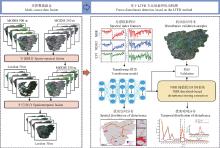
图1
基于多源数据融合与LTFD方法的呼中区森林扰动检测流程"
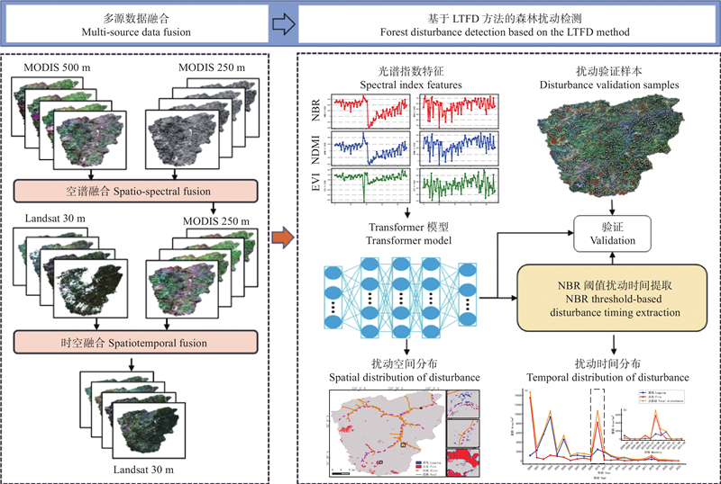
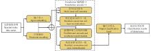
图2
Transformer模型结构"
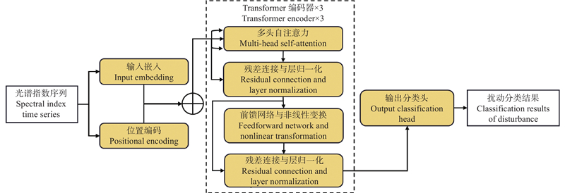

表1
LandTrendr-Y与LandTrendr-M算法参数设置"
| 参数名称Parameter name | LandTrendr-Y | LandTrendr-M |
| maxSegments | 6 | 18 |
| spikeThreshold | 0.9 | 0.95 |
| vertexCountOvershoot | 3 | 5 |
| preventOneYearRecovery | 真True | 真True |
| recoveryThreshold | 0.25 | 0.25 |
| pvalThreshold | 0.05 | 0.05 |
| bestModelProportion | 0.75 | 075 |
| minObservationsNeeded | 6 | 6 |
表2
空谱融合验证结果①"
| 方法Methods | |||||
| BT-H | 0.134 | 0.036 | 0.835 | 0.112 | 0.856 |
| SR-D | 0.027 | 0.006 | 0.967 | 0.065 | 0.929 |
| PSDip | 0.016 | 0.016 | 0.968 | 0.158 | 0.829 |
| ZSPNet | 0.007 | 0.003 | 0.990 | 0.047 | 0.950 |
表3
时空融合验证结果①"
| 方法Methods | RMSE | SAM | ERGAS | CC | SSIM |
| STARFM | 0.021 | 0.072 | 0.913 | 0.793 | 0.941 |
| FSDAF | 0.046 | 0.079 | 5.418 | 0.667 | 0.931 |
| StfNet | 0.020 | 0.053 | 0.774 | 0.862 | 0.958 |
| StfMLP | 0.020 | 0.053 | 0.771 | 0.875 | 0.959 |
表4
不同光谱指数组合输入的LTFD扰动检测结果①"
| 光谱指数组合 Spectral index combination | 扰动分类 Disturbance classification | 参考数据Reference | UA | PA | OA | Kappa | |
| 非扰动Undisturbed | 扰动Disturbed | ||||||
| NBR | 非扰动Undisturbed | 726 | 53 | 0.931 | 0.932 | 0.890 | 0.656 |
| 扰动Disturbed | 54 | 141 | 0.727 | 0.723 | |||
| NBR+EVI | 非扰动Undisturbed | 704 | 26 | 0.903 | 0.964 | 0.895 | 0.701 |
| 扰动Disturbed | 76 | 168 | 0.866 | 0.689 | |||
| NBR+NDMI | 非扰动Undisturbed | 704 | 37 | 0.903 | 0.950 | 0.884 | 0.662 |
| 扰动Disturbed | 76 | 157 | 0.809 | 0.674 | |||
| NBR+NDMI+EVI | 非扰动Undisturbed | 693 | 22 | 0.888 | 0.969 | 0.888 | 0.688 |
| 扰动Disturbed | 87 | 172 | 0.887 | 0.664 | |||
表5
不同扰动检测方法验证结果①"
| 方法 Methods | 扰动分类 Disturbance classification | 参考数据Reference | UA | PA | OA | Kappa | TOA | |
| 非扰动Undisturbed | 扰动Disturbed | |||||||
| LandTrendr-Y | 非扰动Undisturbed | 763 | 89 | 0.978 | 0.896 | 0.891 | 0.604 | 0.686 |
| 扰动Disturbed | 17 | 105 | 0.541 | 0.861 | ||||
| LandTrendr-M | 非扰动Undisturbed | 728 | 92 | 0.933 | 0.888 | 0.852 | 0.498 | 0.088 |
| 扰动Disturbed | 52 | 102 | 0.526 | 0.662 | ||||
| RF | 非扰动Undisturbed | 665 | 24 | 0.853 | 0.965 | 0.857 | 0.620 | 0.742 |
| 扰动Disturbed | 115 | 170 | 0.876 | 0.596 | ||||
| LTFD | 非扰动Undisturbed | 704 | 26 | 0.903 | 0.964 | 0.895 | 0.701 | 0.767 |
| 扰动Disturbed | 76 | 168 | 0.866 | 0.689 | ||||
表6
LTFD与RF扰动分类结果①"
| 方法 Methods | 火灾Fire | 采伐Logging | OA | Kappa | |||
| UA | PA | UA | PA | ||||
| RF | 0.810 | 0.708 | 0.787 | 0.424 | 0.565 | 0.443 | |
| LTFD | 0.886 | 0.809 | 0.787 | 0.543 | 0.662 | 0.564 | |
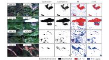
图3
不同扰动检测方法可视化对比"
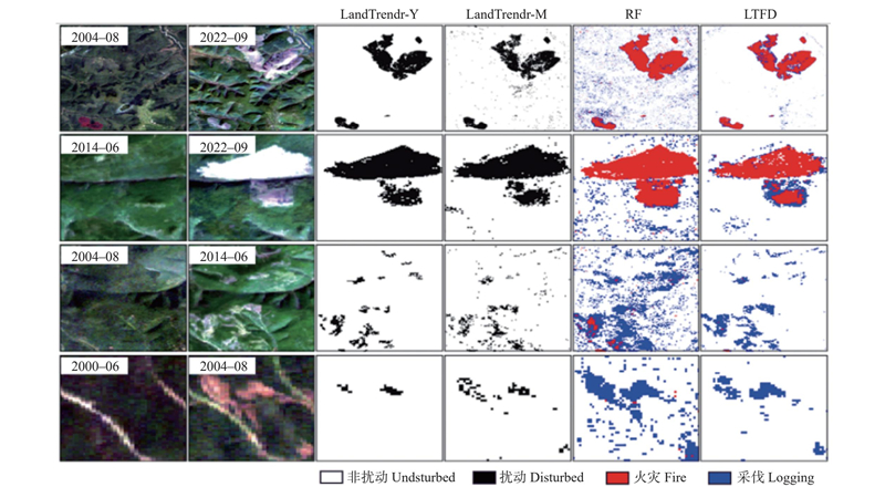
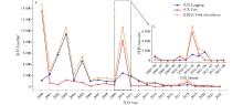
图4
研究区森林扰动面积统计 a:年度扰动面积统计 Annual disturbance area statistics;b:月度扰动面积统计 Monthly disturbance area statistics"
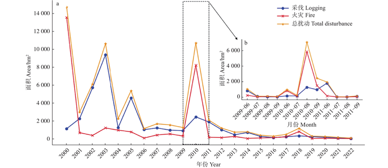
表7
森林扰动面积分阶段统计结果"
| 年份 Year | 火灾面积 Fire area | 采伐面积 Logging area | 总面积 Total area |
| 2000—2005 | 17 726.22 | 24 430.32 | 42 156.54 |
| 2006—2010 | 9 752.76 | 6 712.29 | 16 465.05 |
| 2011—2015 | 883.35 | 4 477.41 | 5 360.76 |
| 2016—2022 | 1 533.33 | 1 453.05 | 2 986.38 |
| 陈宏伟, 胡远满, 常 禹, 等. 森林采伐方式对森林景观的影响模拟: 以大兴安岭呼中林区为例. 生态学杂志, 2013, 32 (7): 1888- 1895. | |
| Chen H W, Hu Y M, Chang Y, et al. Simulation of the effect of forest harvest mode on forest landscape: a case study in Huzhong forest region of Daxing’anling Mountains, China. Chinese Journal of Ecology, 2013, 32 (7): 1888- 1895. | |
| 毛学刚, 姚 瑶, 范文义. 基于Landsat长时间序列的森林扰动参数提取与树高估算. 林业科学, 2019, 55 (3): 79- 87. | |
| Mao X G, Yao Y, Fan W Y. Extraction of forest disturbance parameters and estimation of forest height based on long time-series Landsat. Scientia Silvae Sinicae, 2019, 55 (3): 79- 87. | |
| 沈文娟, 李明诗, 黄成全. 长时间序列多源遥感数据的森林干扰监测算法研究进展. 遥感学报, 2018, 22 (6): 1005- 1022. | |
| Shen W J, Li M S, Huang C Q. Review of remote sensing algorithms for monitoring forest disturbance from time series and multi-source data fusion. National Remote Sensing Bulletin, 2018, 22 (6): 1005- 1022. | |
|
王 晨, 庞 勇, 袁智文, 等. 基于LandTrendr算法和森林资源清查数据的海南岛森林扰动监测与分析. 生态学报, 2025, 45 (16): 8054- 8070.
doi: 10.20103/j.stxb.202409092167 |
|
|
Wang C, Pang Y, Yuan Z W, et al. Forest disturbance monitoring and analysis based on LandTrendr algorithm and forest resource inventory data in Hainan Island. Acta Ecologica Sinica, 2025, 45 (16): 8054- 8070.
doi: 10.20103/j.stxb.202409092167 |
|
|
王明玉, 李伟克, 舒立福, 等. 雷击火高发的呼中地区瞭望塔配置的可视性评价. 林业科学, 2023, 59 (10): 9- 21.
doi: 10.11707/j.1001-7488.LYKX20220917 |
|
|
Wang M Y, Li W K, Shu L F, et al. Visibility evaluation of the lookout tower configuration in Huzhong area where lightning fires frequently occur. Scientia Silvae Sinicae, 2023, 59 (10): 9- 21.
doi: 10.11707/j.1001-7488.LYKX20220917 |
|
|
王 宁, 岳彩荣, 罗洪斌, 等. 森林扰动遥感影像检测方法研究进展. 世界林业研究, 2022, 35 (4): 40- 46.
doi: 10.13348/j.cnki.sjlyyj.2022.0022.y |
|
|
Wang N, Yue C R, Luo H B, et al. Review on forest disturbance detection methods by remote sensing. World Forestry Research, 2022, 35 (4): 40- 46.
doi: 10.13348/j.cnki.sjlyyj.2022.0022.y |
|
|
吴 伶, 刘湘南, 刘美玲, 等. 融合遥感时间序列时空谱信息的森林扰动检测与归因研究进展. 遥感学报, 2024, 28 (3): 558- 575.
doi: 10.11834/jrs.20232211 |
|
|
Wu L, Liu X N, Liu M L, et al. Review of the detection and attribution of multi-type forest disturbances using an ensemble of spatio-temporal-spectral information from remote sensing images. National Remote Sensing Bulletin, 2024, 28 (3): 558- 575.
doi: 10.11834/jrs.20232211 |
|
| 肖 亮, 刘鹏飞, 李 恒. 多源空−谱遥感图像融合方法进展与挑战. 中国图象图形学报, 2020, 25 (5): 851- 863. | |
| Xiao L, Liu P F, Li H. Progress and challenges in the fusion of multisource spatial−spectral remote sensing images. Journal of Image and Graphics, 2020, 25 (5): 851- 863. | |
|
杨广奇, 刘 慧, 钟锡武, 等. 遥感图像时空融合综述. 计算机工程与应用, 2022, 58 (10): 27- 40.
doi: 10.3778/j.issn.1002-8331.2111-0131 |
|
|
Yang G Q, Liu H, Zhong X W, et al. Temporal and spatial fusion of remote sensing images: a review. Computer Engineering and Applications, 2022, 58 (10): 27- 40.
doi: 10.3778/j.issn.1002-8331.2111-0131 |
|
|
杨宇迪, 郭 颖, 田 昕, 等. 多时间分辨率遥感森林变化监测方法综述. 遥感技术与应用, 2025, 40 (4): 1026- 1035.
doi: 10.11873/j.issn.1004-0323.2025.4.1026 |
|
|
Yang Y D, Guo Y, Tian X, et al. Review of multi-time resolution remote sensing forest change detection methods. Remote Sensing Technology and Application, 2025, 40 (4): 1026- 1035.
doi: 10.11873/j.issn.1004-0323.2025.4.1026 |
|
|
郑明心, 李玥莹, 王肇钧, 等. 干扰对森林土壤动物群落特征的影响. 生态学杂志, 2026, 45 (2): 606- 616.
doi: 10.13292/j.1000-4890.202602.050 |
|
|
Zheng M X, Li Y Y, Wang Z J, et al. The impacts of disturbance on soil faunal communities in forests. Chinese Journal of Ecology, 2026, 45 (2): 606- 616.
doi: 10.13292/j.1000-4890.202602.050 |
|
|
钟 莉, 陈芸芝, 汪小钦. 基于Landsat时序数据的森林干扰监测. 林业科学, 2020, 56 (5): 80- 88.
doi: 10.11707/j.1001-7488.20200509 |
|
|
Zhong L, Chen Y Z, Wang X Q. Forest disturbance monitoring based on time series of Landsat data. Scientia Silvae Sinicae, 2020, 56 (5): 80- 88.
doi: 10.11707/j.1001-7488.20200509 |
|
|
Bhat Y, Nandy S, Das K, et al. Vegetation disturbance and regrowth dynamics in shifting cultivation landscapes. Scientific Reports, 2024, 14 (1): 28324.
doi: 10.1038/s41598-024-78089-9 |
|
|
Breiman L. Random forests. Machine Learning, 2001, 45 (1): 5- 32.
doi: 10.1023/A:1010933404324 |
|
|
Cai J J, Huang B, Fung T. Progressive spatiotemporal image fusion with deep neural networks. International Journal of Applied Earth Observation and Geoinformation, 2022, 108, 102745.
doi: 10.1016/j.jag.2022.102745 |
|
|
Cai Y T, Li X, Zhu P, et al. China earth observation data cube: the 30-m seamless annual leaf-on Landsat composites from 1985 to 2023. Journal of Remote Sensing, 2025, 5, 698.
doi: 10.34133/remotesensing.0698 |
|
|
Chen G S, Lu H L, Di D L, et al. StfMLP: spatiotemporal fusion multilayer perceptron for remote-sensing images. IEEE Geoscience and Remote Sensing Letters, 2023, 20, 5000105.
doi: 10.1109/lgrs.2022.3230720 |
|
|
Du B, Yuan Z L, Bo Y C, et al. A combined deep learning and prior knowledge constraint approach for large-scale forest disturbance detection using time series remote sensing data. Remote Sensing, 2023, 15 (12): 2963.
doi: 10.3390/rs15122963 |
|
|
Foga S, Scaramuzza P L, Guo S, et al. Cloud detection algorithm comparison and validation for operational Landsat data products. Remote Sensing of Environment, 2017, 194, 379- 390.
doi: 10.1016/j.rse.2017.03.026 |
|
|
Gao F, Masek J, Schwaller M, et al. On the blending of the Landsat and MODIS surface reflectance: predicting daily Landsat surface reflectance. IEEE Transactions on Geoscience and Remote Sensing, 2006, 44 (8): 2207- 2218.
doi: 10.1109/TGRS.2006.872081 |
|
|
Hansen M C, Potapov P V, Moore R, et al. High-resolution global maps of 21st-century forest cover change. Science, 2013, 342 (6160): 850- 853.
doi: 10.1126/science.1244693 |
|
|
Kennedy R E, Yang Z Q, Gorelick N, et al. Implementation of the LandTrendr algorithm on google earth engine. Remote Sensing, 2018, 10 (5): 691.
doi: 10.3390/rs10050691 |
|
|
Liu X, Deng C W, Chanussot J, et al. StfNet: a two-stream convolutional neural network for spatiotemporal image fusion. IEEE Transactions on Geoscience and Remote Sensing, 2019, 57 (9): 6552- 6564.
doi: 10.1109/TGRS.2019.2907310 |
|
|
Liu Z, Zhang Y R, Zheng X. Improving urban forest expansion detection with LandTrendr and machine learning. Forests, 2024, 15 (8): 1452.
doi: 10.3390/f15081452 |
|
|
Lu H L, Paoletti M E, Haut J M, et al. A novel spectral-spatial attention network for zero-shot pansharpening. IEEE Journal of Selected Topics in Applied Earth Observations and Remote Sensing, 2025, 18, 19805- 19820.
doi: 10.1109/JSTARS.2025.3587244 |
|
|
Lolli S, Alparone L, Garzelli A, et al. Haze correction for contrast-based multispectral pansharpening. IEEE Geoscience and Remote Sensing Letters, 2017, 14 (12): 2255- 2259.
doi: 10.1109/LGRS.2017.2761021 |
|
|
Marinelli D, Dalponte M, Frizzera L, et al. A method for continuous sub-annual mapping of forest disturbances using optical time series. Remote Sensing of Environment, 2023, 299, 113852.
doi: 10.1016/j.rse.2023.113852 |
|
|
Perbet P, Guindon L, Côté J F, et al. Evaluating deep learning methods applied to Landsat time series subsequences to detect and classify boreal forest disturbances events: The challenge of partial and progressive disturbances. Remote Sensing of Environment, 2024, 306, 114107.
doi: 10.1016/j.rse.2024.114107 |
|
|
Peng Y D, Li W S, Luo X B, et al. Integrated fusion framework based on semicoupled sparse tensor factorization for spatio-temporal-spectral fusion of remote sensing images. Information Fusion, 2021, 65, 21- 36.
doi: 10.1016/j.inffus.2020.08.013 |
|
|
Potapov P, Hansen M C, Pickens A, et al. The global 2000–2020 land cover and land use change dataset derived from the Landsat archive: first results. Frontiers in Remote Sensing, 2022, 3, 856903.
doi: 10.3389/frsen.2022.856903 |
|
|
Qiu D A, Liang Y J, Shang R, et al. Improving LandTrendr forest disturbance mapping in China using multi-season observations and multispectral indices. Remote Sensing, 2023, 15 (9): 2381.
doi: 10.3390/rs15092381 |
|
|
Rui X Y, Cao X Y, Li Y N, et al. Variational zero-shot multispectral pansharpening. IEEE Transactions on Geoscience and Remote Sensing, 2024, 62, 5409716.
doi: 10.1109/tgrs.2024.3492059 |
|
|
Schiller C, Költzow J, Schwarz S, et al. Forest disturbance detection in Central Europe using transformers and Sentinel-2 time series. Remote Sensing of Environment, 2024, 315, 114475.
doi: 10.1016/j.rse.2024.114475 |
|
| Vaswani A, Shazeer N, Parmar N, et al. 2017. Attention is all you need. In 31st Conference on Neural Information Processing Systems (NIPS 2017), Long Beach, CA, USA. | |
|
Vicinanza M R, Restaino R, Vivone G, et al. A pansharpening method based on the sparse representation of injected details. IEEE Geoscience and Remote Sensing Letters, 2015, 12 (1): 180- 184.
doi: 10.1109/LGRS.2014.2331291 |
|
|
Wang J, Wang J D, Zhou H M, et al. Detecting forest disturbance in northeast China from GLASS LAI time series data using a dynamic model. Remote Sensing, 2017a, 9 (12): 1293.
doi: 10.3390/rs9121293 |
|
|
Wang L H, Wei F L, Tagesson T, et al. Transforming forest management through rewilding: enhancing biodiversity, resilience, and biosphere sustainability under global change. One Earth, 2025, 8 (3): 101195.
doi: 10.1016/j.oneear.2025.101195 |
|
|
Wang L, Liu S D, Song W J, et al. Global high-resolution forest disturbance type dataset. Earth System Science Data, 2026, 18 (2): 1601- 1617.
doi: 10.5194/essd-18-1601-2026 |
|
|
Wang Q M, Zhang Y H, Onojeghuo A O, et al. Enhancing spatio-temporal fusion of MODIS and Landsat data by incorporating 250 m MODIS data. IEEE Journal of Selected Topics in Applied Earth Observations and Remote Sensing, 2017b, 10 (9): 4116- 4123.
doi: 10.1109/JSTARS.2017.2701643 |
|
|
Xu K, Lin W S, Zhang N. Comparative analysis of forest disturbance detection in the key state-owned forest region of the Greater Khingan Range of China based on different algorithms. Geocarto International, 2025, 40, 2489526.
doi: 10.1080/10106049.2025.2489526 |
|
|
Zhang X, Zhao T T, Xu H, et al. GLC_FCS30D: the first global 30 m land-cover dynamics monitoring product with a fine classification system for the period from 1985 to 2022 generated using dense-time-series Landsat imagery and the continuous change-detection method. Earth System Science Data, 2024, 16 (3): 1353- 1381.
doi: 10.5194/essd-16-1353-2024 |
|
|
Zhou G X, Liu M, Liu X N. An autoencoder-based model for forest disturbance detection using Landsat time series data. International Journal of Digital Earth, 2021, 14 (9): 1087- 1102.
doi: 10.1080/17538947.2021.1949399 |
|
|
Zhu X L, Helmer E H, Gao F, et al. A flexible spatiotemporal method for fusing satellite images with different resolutions. Remote Sensing of Environment, 2016, 172, 165- 177.
doi: 10.1016/j.rse.2015.11.016 |
| [1] | 张兴,颜宇凡,付波霖,李景文,于灵雪,李颖,邓荣鑫,孙静. 一种基于ENVINet5-SME的农田防护林自动提取方法[J]. 林业科学, 2026, 62(9): 124-138. |
| [2] | 徐泽宇,李荣荣. 基于轻量化特征融合与空间重构的竹条表面缺陷检测算法[J]. 林业科学, 2026, 62(7): 186-196. |
| [3] | 姚宗琦,雷令婷,柴国奇,霍朗宁,田昕,张晓丽. 星载多光谱与SAR协同的地表覆盖及森林类型变化检测方法[J]. 林业科学, 2026, 62(2): 160-172. |
| [4] | 李尧迪,田野,张长春,谢将剑,赵海涛,张军国. 基于深度学习的野生动物图像识别方法与挑战[J]. 林业科学, 2026, 62(1): 207-222. |
| [5] | 崔泽宇,张怀清,刘洋,张京,杨廷栋,傅汝饶. 树木三维建模与可视化模拟技术进展与应用[J]. 林业科学, 2025, 61(6): 1-12. |
| [6] | 葛晓宁,许新桥,张怀清,张京,杨杰,崔泽宇,傅汝饶,梁金洁,邹添华,王林龙,刘洋. 林木基因型-环境互作算法研究进展与思考[J]. 林业科学, 2025, 61(3): 1-15. |
| [7] | 纪敏,高锐,王晓欢,刁兴良,韩佳锴,赵扬,王国富,张伟. 基于深度学习的结构用锯材节子在线检测方法[J]. 林业科学, 2025, 61(11): 150-159. |
| [8] | 谢婉滢,刘文萍,王晗. 无人机松林图像早期松材线虫病害检测[J]. 林业科学, 2024, 60(9): 124-133. |
| [9] | 齐建东,郑尚姿,陈子仪,马鐘添. 基于ConvNeXt的北京地区红外相机野生动物图像识别改进模型构建[J]. 林业科学, 2024, 60(8): 33-45. |
| [10] | 田智康,葛浙东,郑焕祺,郑志帅,周玉成. 基于深度学习的75种阔叶材微观辨识方法[J]. 林业科学, 2024, 60(10): 94-103. |
| [11] | 齐建东,马鐘添,张德怀,田赟. 基于BS-ResNeXt-50的密云地区野生动物图像识别[J]. 林业科学, 2023, 59(8): 112-122. |
| [12] | 李贾,兰岚,张佐忠,袁文涛,高德民,宗树琴,业巧林. 基于深度学习的森林可燃物含水率反演技术[J]. 林业科学, 2022, 58(10): 47-58. |
| [13] | 田相林,廖梓延,孙帅超,薛海连,王彬,曹田健. 多源数据对林分动态预测的影响及不确定性分析[J]. 林业科学, 2021, 57(3): 51-66. |
| [14] | 周焱,刘文萍,骆有庆,宗世祥. 基于深度学习的小目标受灾树木检测方法[J]. 林业科学, 2021, 57(3): 98-107. |
| [15] | 郭颖,李增元,陈尔学,张旭,赵磊,陈艳,王雅慧. 一种改进的高空间分辨率遥感影像森林类型深度学习精细分类方法:双支FCN-8s[J]. 林业科学, 2020, 56(3): 48-60. |
| 阅读次数 | ||||||
|
全文 |
|
|||||
|
摘要 |
|
|||||

