
Scientia Silvae Sinicae ›› 2023, Vol. 59 ›› Issue (8): 90-101.doi: 10.11707/j.1001-7488.LYKX20220531
• Research papers • Previous Articles Next Articles
Bo Wang1( ),Xueqing Yang2,Chunying Jiang2,Dong Liu3,Feng Chen1,Ye Bai1,Xiaodong Liu1,*
Received:2022-08-02
Online:2023-08-25
Published:2023-10-16
Contact:
Xiaodong Liu
E-mail:2293777945@qq.com
CLC Number:
Bo Wang,Xueqing Yang,Chunying Jiang,Dong Liu,Feng Chen,Ye Bai,Xiaodong Liu. Forest Fire Spread Risk in Yanqing District of Beijing Based on GIS[J]. Scientia Silvae Sinicae, 2023, 59(8): 90-101.
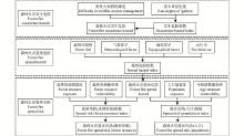
Fig.1
The assessment framework of forest fire spread risk"
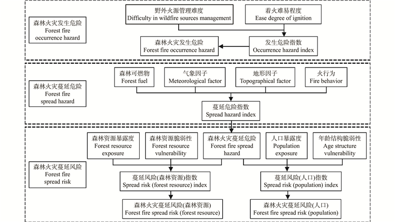
Table 1
The assessment index of forest fire occurrence hazard"
| 一级指标 First level index | 二级指标 Secondary index | 计算方式 Calculation |
| 野外火源管理难度 Difficulty in wildfire sources management | 祭祀用火重点人群密度 Sacrificial fire key population density | 林区及林缘100 m范围内祭祀用火重点人群(60岁至79岁)数量与评估区域的林地面积之比,单位为person·hm?2。Ratio of the number of key groups (aged 60 to 79) for sacrificial fire to the forest area of the evaluation area within 100 meters of forest area and forest edge, in person·hm?2. |
| 农事用火风险区域面积 Area of agricultural fire risk area | 林区及林缘100 m范围内耕地面积与评估区域的林地面积之比,量纲为一。The ratio of cultivated land area within 100 meters of forest area and forest edge to woodland area of evaluation area, without dimensionality. | |
| 路旁烟头风险区域长度 Length of roadside cigarette butts risk area | 林区及林缘100 m范围内交通建设用地小班的长度与评估区域林地面积之比,单位为km·hm?2。The ratio of the length of traffic construction land subclass within 100 meters of forest area and forest edge to the area of forest land in the evaluation region, in km·hm?2. | |
| 着火难易程度 Ease degree of ignition | 防火期月最小相对湿度Minimum monthly relative humidity during fire prevention period | 防火期期间,月每日最小相对湿度的最小值,单位为%。The minimum daily relative humidity of a month during the fire prevention period, in %. |
| 防火期月平均风速 Monthly mean wind speed during fire prevention period | 防火期期间,月每日平均风速的平均值,单位为m·s?1。Average monthly average daily wind speed during the fire prevention period, in m·s?1. | |
| 细小可燃物载量 Fine fuel load | 单位面积1h时滞可燃物(直径<0.64 cm)、枯死杂草和上层枯叶载量,单位为t·hm?2。1 hour delay fuel (diameter<0.64 cm), dead weeds and upper layer dead leaf load in unit area, in t·hm?2. |
Table 2
The assessment index of forest fire spread hazard"
| 一级指标 First level index | 二级指标Secondary index | 计算方式 Calculation |
| 森林可燃物 Forest fuel | 地表可燃物载量Surface fuel load | 单位面积地表可燃物(灌木、草本、枯落物)载量,单位为t·hm?2。Amount of surface fuel (shrub, herb, litter) per unit area, in t·hm?2. |
| 灌草植被总覆盖度Total coverage of shrub and grass vegetation | 林地灌草层的总覆盖度,单位为%。Total coverage of shrub and grass layer in woodland, in %. | |
| 森林燃烧性Forest flammability | 森林被引燃着火的难易程度以及着火后所表现出的燃烧状态(火种类)和燃烧速度、火强度等的综合,也可以衡量森林燃烧释放能量的大小,量纲为一。It is also possible to measure the size of energy released by forest combustion, dimensionless, by the combination of the difficulty of forest ignition and the combustion state (fire type) and the combustion speed and fire intensity after ignition. | |
| 气象因子 Meteorological factor | 防火期月大风日数Monthly gale days during fire prevention period | 防火期期间,月平均出现瞬时风力5级或以上的天气日数,单位为days。During the fire prevention period, the monthly average number of weather days with instantaneous wind force 5 or above is expressed in days. |
| 防火期月降水量Monthly precipitation during fire prevention period | 防火期期间,总降雨量的月平均值,单位为mm。The monthly average of total rainfall during the fire prevention period, in mm. | |
| 防火期月平均最高气温Monthly mean maximum temperature during fire prevention period | 防火期期间,日最高气温的平均值,单位为℃。Average daily maximum temperature during the fire prevention period, in ℃. | |
| 地形因子 Topographical factor | 海拔Elevation | 高出海平面的垂直距离,单位为m。The vertical distance above sea level, in m. |
| 坡度Slope | 坡面的垂直高度和水平宽度的比值,单位为%。The ratio of vertical height to horizontal width of a slope, in %. | |
| 坡向Aspect | 坡面的朝向,量纲为一。Orientation of slope, dimensionless. | |
| 坡位Slope position | 坡面所处的地貌部位,量纲为一。The landform on which a slope is located, dimensionless. | |
| 火行为 Fire behavior | 地表火蔓延速度Surface fire spread speed | 地表火的火线在单位时间内向前移动的距离,单位是m·min?1。The distance that the surface fire line moves forward per unit time, in m·min?1. |
| 火线强度Fire intensity | 火头前沿单位长度上热量释放速度,单位是kW·m?1。Heat release rate per unit length of fire head front, in kW·m?1. | |
| 火焰高度Flame height | 垂直于地面连续的火焰高度,单位是m。Continuous flame height perpendicular to the ground, in m. |
Table 3
Standard for classification of forest fire spread risk level"
| 森林火灾蔓延风险指数 Forest fire spread risk index | 1 | (1,1.5] | (1.5,2] | (2,3] | (3,4] |
| 森林火灾蔓延风险等级 Forest fire spread risk level | 极高风险 Extremely high risk | 中高风险 Medium-high risk | 中风险 Medium risk | 中低风险 Medium-low risk | 低风险 Low risk |
Table 4
Forest fire occurrence hazard assessment index weight"
| 一级指标 First level index | 一级指标 综合权重Comprehensive weight of first level index | 二级指标 Secondary index | 二级指标层次分析权重Chromatography analysis weight of secondary index | 二级指标熵权重Entropy weight of secondary index | 二级指标综合权重Comprehensive weight of secondary index | 指标类型 Index type | 计算尺度 Computing scale |
| 野外火源管理难度Difficulty in wildfire sources management | 0.7713 | 祭祀用火重点人群密度Sacrificial fire key population density | 0.2415 | 0.3093 | 0.2754 | 正向Positive | 村屯Village |
| 农事用火风险区域面积Area of agricultural fire risk area | 0.2402 | 0.2839 | 0.2621 | 正向Positive | 村屯Village | ||
| 路旁烟头风险区域长度Length of roadside cigarette butts risk area | 0.2365 | 0.2311 | 0.2338 | 正向Positive | 村屯Village | ||
| 着火难易程度Ease degree of ignition | 0.2287 | 防火期月最小相对湿度Minimum monthly relative humidity during fire prevention period | 0.1081 | 0.0380 | 0.0730 | 负向Negative | 小班Subcompartment |
| 防火期月平均风速Monthly mean wind speed during fire prevention period | 0.0474 | 0.0914 | 0.0694 | 正向Positive | 小班Subcompartment | ||
| 细小可燃物载量Fine fuel load | 0.1263 | 0.0463 | 0.0863 | 正向Positive | 小班Subcompartment |
Table 5
Forest fire spread hazard assessment index weight"
| 一级指标First level index | 一级指标 综合权重Comprehensive weight of first level index | 二级指标Secondary index | 二级指标层次分析权重Chromatography analysis weight of secondary index | 二级指标熵权重Entropy weight of secondary index | 二级指标综合权重Comprehensive weight of secondary index | 指标类型 Index type | 计算尺度Computing scale |
| 森林可燃物Forest fuel | 0.1982 | 地表可燃物载量Surface fuel load | 0.0812 | 0.0314 | 0.0563 | 正向Positive | 小班Subcompartment |
| 灌草植被总覆盖度Total coverage of shrub and grass vegetation | 0.1132 | 0.0845 | 0.0989 | 正向Positive | 小班Subcompartment | ||
| 森林燃烧性Forest flammability | 0.0735 | 0.0125 | 0.0430 | 正向Positive | 小班Subcompartment | ||
| 气象因子Meteorological factor | 0.1414 | 防火期月大风日数Monthly gale days during fire prevention period | 0.1153 | 0.0205 | 0.0679 | 正向Positive | 小班Subcompartment |
| 防火期月降水量Monthly precipitation during fire prevention period | 0.0524 | 0.0228 | 0.0376 | 负向Negative | 小班Subcompartment | ||
| 防火期月平均最高气温Monthly mean maximum temperature during fire prevention period | 0.0501 | 0.0216 | 0.0359 | 正向Positive | 小班Subcompartment | ||
| 地形因子Topographical factor | 0.2572 | 海拔Elevation | 0.0126 | 0.0017 | 0.0071 | 负向Negative | 小班Subcompartment |
| 坡度Slope | 0.1249 | 0.1895 | 0.1572 | 正向Positive | 小班Subcompartment | ||
| 坡向Aspect | 0.0508 | 0.0411 | 0.0460 | 正向Positive | 小班Subcompartment | ||
| 坡位Slope position | 0.0522 | 0.0417 | 0.0469 | 正向Positive | 小班Subcompartment | ||
| 火行为 Fire behavior | 0.4032 | 地表火蔓延速度Surface fire spread speed | 0.1265 | 0.1964 | 0.1614 | 正向Positive | 小班Subcompartment |
| 火线强度Fire intensity | 0.0781 | 0.2019 | 0.1400 | 正向Positive | 小班Subcompartment | ||
| 火焰高度Flame height | 0.0692 | 0.1344 | 0.1018 | 正向Positive | 小班Subcompartment |
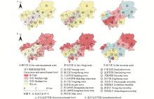
Fig.2
Multi-scale forest fire occurrence and spread hazard level in Yanqing District"

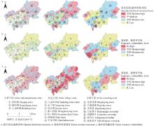
Fig.3
Multi-scale forest fire spread risk (forest resource), forest resource exposure and vulnerability level in Yanqing District"

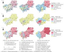
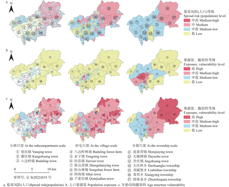
Fig.4
Multi-scale forest fire spread risk (population), population exposure and age structure vulnerability level in Yanqing District"
| 国务院第一次全国自然灾害综合风险普查领导小组办公室. 2021. 森林和草原火灾风险调查与评估. 北京: 应急管理出版社. | |
| Office of the Leading Group for the First National Comprehensive Survey of Natural Disaster Risks under The State Council. 2021. Forest and grassland fire risk investigation and assessment. Beijing: Emergency Management Press.[in Chinese] | |
| 国志兴, 钟兴春, 方伟华, 等. 野火蔓延灾害风险评估研究进展. 地理科学进展, 2010, 29 (7): 778- 788. | |
| Guo Z X, Zhong X C, Fang W H, et al. The research advances of wildfire spreading and wildfire risk assessment. Progress in Geography, 2010, 29 (7): 778- 788. | |
| 侯丽丽, 都瓦拉, 银 山, 等. 基于牧户尺度的草原火灾风险评价——以东乌旗汗敖包嘎查为例. 生态学报, 2022, 42 (3): 1059- 1070. | |
| Hou L L, Du W L, Yin S, et al. Grassland fire risk assessment based on herder scale: Taking Khan Obo village, eastern Wuzhumuqin Banner as an example. Acta Ecologica Sinica, 2022, 42 (3): 1059- 1070. | |
| 胡海清. 2005. 林火生态与管理. 北京: 中国林业出版社. | |
| Hu H Q. 2005. Forest fire ecology and management. Beijing: China Forestry Publishing House.[in Chinese] | |
| 阚振国. 2006. 林火基础理论. 北京: 人民武警出版社. | |
| Kan Z G. 2006. Forest fire basic theory. Beijing: People’s Armed Police Press.[in Chinese] | |
| 李连强, 牛树奎, 陈 锋, 等. 北京妙峰山林场地表潜在火行为及燃烧性分析. 北京林业大学学报, 2019, 41 (3): 58- 67. | |
| Li L Q, Niu S K, Chen F, et al. Analysis on surface potential fire behavior and combustion of Miaofeng Mountain Forest Farm in Beijing. Journal of Beijing Forestry University, 2019, 41 (3): 58- 67. | |
| 刘冠宏. 2019. 北京地区典型林分地表火及向树冠火蔓延机制研究. 北京: 北京林业大学. | |
| Liu G H. 2019. Study on the mechanism of surface fire and spread of canopy fire of typical tree species in Beijing area. Beijing: MS thesis of Beijing Forestry University.[in Chinese] | |
| 马玉春, 赵彦飞. 森林灭火安全防范与紧急避险探讨. 消防科学与技术, 2021, 40 (1): 5- 7. | |
| Ma Y C, Zhao Y F. Discussion on safety precaution and emergency avoidance of forest fire fighting. Fire Science and Technology, 2021, 40 (1): 5- 7. | |
| 牛树奎. 2012. 北京山区主要森林类型火行为与可燃物空间连续性研究. 北京: 北京林业大学. | |
| Niu S K. 2012. Fire behavior and fuel spatial continuity of major forest types in the mountainous area, Beijing. Beijing: Beijing Forestry University.[in Chinese] | |
| 牛树奎, 崔国发, 雷 鸣, 等. 北京喇叭沟门林区森林燃烧性及防火区研究. 北京林业大学学报, 2000, 22 (4): 109- 112. | |
| Niu S K, Cui G F, Lei M, et al. Study on the forest combustibility and the fire districts in Labagoumen forest region. Journal of Beijing Forestry University, 2000, 22 (4): 109- 112. | |
| 孙朝峰, 吴 立, 黄川容, 等. 基于GIS的福建省塑料大棚风害风险评估与区划. 气象与环境科学, 2022, 45 (4): 67- 73. | |
| Sun C F, Wu L, Huang C R, et al. Risk assessment and division of wind damage to plastic greenhouses in Fujian province based on geographic information system. Meteorological and Environmental Sciences, 2022, 45 (4): 67- 73. | |
| 孙志超, 杨雪清, 李 超. 小型无人机非测量相机在林业调查中的应用研究. 林业资源管理, 2017, (2): 103- 109. | |
| Sun Z C, Yang X Q, Li C. Application of small unmanned aerial vehicle with non-measuring camera in forestry investigation. Forest Resources Management, 2017, (2): 103- 109. | |
| 唐博海. 2016. 基于Web GIS的森林火灾风险评估. 哈尔滨: 哈尔滨师范大学. | |
| Tang B H. 2016. Forest fire risk assessment based on Web GIS. Harbin: Harbin Normal University.[in Chinese] | |
| 王 兵, 牛 香, 宋庆丰. 中国森林生态系统服务评估及其价值化实现路径设计. 环境保护, 2020, 48 (14): 28- 36. | |
| Wang B, Niu X, Song Q F. Forest ecosystem service assessment and path design of value-oriented realization in China. Environmental Protection, 2020, 48 (14): 28- 36. | |
|
王睿琛, 张文文, 龙腾腾, 等. 森林火灾风险性评估方法综述. 林业调查规划, 2021, 46 (6): 44- 47,54.
doi: 10.3969/j.issn.1671-3168.2021.06.008 |
|
|
Wang R C, Zhang W W, Long T T, et al. Review of forest fire risk assessment methods. Forest Inventory and Planning, 2021, 46 (6): 44- 47,54.
doi: 10.3969/j.issn.1671-3168.2021.06.008 |
|
| 王晓丽. 2010. 北京山区森林燃烧性研究. 北京: 北京林业大学博士学位论文. | |
| Wang X L. 2010. Study on combustibility of forests in Beijing Mountain Area. Beijing: PhD thesis of Beijing Forestry University.[in Chinese] | |
| 王卫国. 2017. 甘肃省火灾风险评价与区划研究. 兰州: 西北师范大学. | |
| Wang W G. 2017. Study on the assessment of fire risk and zoning in Gansu Province. Lanzhou: Northwest Normal University.[in Chinese] | |
| 尹赛男, 王东昶, 单延龙, 等. 黑龙江省3种主要火源引发森林火灾的次数和面积时空分布特征. 林业科学, 2021, 57 (6): 115- 124. | |
| Yin S N, Wang D C, Shan Y L, et al. Spatial and temporal distribution of forest fires (frequency and area) caused by three main fire sources in Heilongjiang Province. Scientia Silvae Sinicae, 2021, 57 (6): 115- 124. | |
|
Adab H, Atabati A, Oliveira S, et al. Assessing fire hazard potential and its main drivers in Mazandaran province, Iran: a data-driven approach. Environmental Monitoring and Assessment, 2018, 190, 670.
doi: 10.1007/s10661-018-7052-1 |
|
|
Aparício B A, Pereira J M C, Santos F C, et al. Combining wildfire behaviour simulations and network analysis to support wildfire management: A Mediterranean landscape case study. Ecological Indicators, 2022, 137, 108726.
doi: 10.1016/j.ecolind.2022.108726 |
|
| Calkin D E, Ager A A, Gilbertson D J. 2010. Wildfire risk and hazard: procedures for the first approximation. General Technical Report RMRS-GTR-235. Fort Collins, CO: U. S. Department of Agriculture, Forest Service, Rocky Mountain Research Station, 62 . | |
|
Chuvieco E, Aguado I, Yebra M, et al. Development of a framework for fire risk assessment using remote sensing and geographic information system technologies. Ecological Modelling, 2010, 221 (1): 46- 58.
doi: 10.1016/j.ecolmodel.2008.11.017 |
|
|
Heisig J, Olson E, Pebesma E. Predicting wildfire fuels and hazard in a central European temperate forest using active and passive remote sensing. Fire, 2022, 5, 29.
doi: 10.3390/fire5010029 |
|
|
Hysa A, Baskaya F A T. A GIS based method for indexing the broad-leaved forest surfaces by their wildfire ignition probability and wildfire spreading capacity. Modeling Earth Systems and Environment, 2019, 5 (1): 71- 84.
doi: 10.1007/s40808-018-0519-9 |
|
|
Hysa A, Teqja Z, Bani A, et al. Assessing wildfire vulnerability of vegetated serpentine soils in the Balkan peninsula. Journal for Nature Conservation, 2022, 68, 126217.
doi: 10.1016/j.jnc.2022.126217 |
|
|
Li X N, Shao X H, Li R Q, et al. Optimization of tobacco water-fertilizer coupling scheme under effective microorganisms biochar-based fertilizer application condition. Agronomy Journal, 2021, 113 (2): 1653- 1663.
doi: 10.1002/agj2.20568 |
|
| Milanović S, Marković N, Pamučar D, et al. Forest fire probability mapping in eastern Serbia: Logistic regression versus random forest method. Forests, 2021, 12, 5. | |
|
Nasiri V, Sadeghi S M M, Bagherabadi R, et al. Modeling wildfire risk in western Iran based on the integration of AHP and GIS. Environmental Monitoring and Assessment, 2022, 194, 644.
doi: 10.1007/s10661-022-10318-y |
|
|
Rodrigues M, Zúñiga-Antón M, Alcasena F, et al. Integrating geospatial wildfire models to delineate landscape management zones and inform decision-making in Mediterranean areas. Safety Science, 2022, 147, 105616.
doi: 10.1016/j.ssci.2021.105616 |
|
|
Wu J R, Chen X L, Lu J Z. Assessment of long and short-term flood risk using the multi-criteria analysis model with the AHP—Entropy method in Poyang Lake basin. International Journal of Disaster Risk Reduction, 2022, 75, 102968.
doi: 10.1016/j.ijdrr.2022.102968 |
|
|
Xiang K X, Zhou Y, Zhou E Z, et al. A spatial assessment of wildfire risk for transmission-line corridor based on a weighted naïve bayes model. Frontiers in Energy Research, 2022, 10, 829934.
doi: 10.3389/fenrg.2022.829934 |
|
|
You W B, Lin L, Wu L Y, et al. Geographical information system-based forest fire risk assessment integrating national forest inventory data and analysis of its spatiotemporal variability. Ecological Indicators, 2017, 77, 176- 184.
doi: 10.1016/j.ecolind.2017.01.042 |
|
| Zhang L, Huo Z G, Zhang L Z, et al. Integrated risk assessment of major meteorological disasters with paprika pepper in Hainan province. Journal of Tropical Meteorology, 2017, 23 (3): 334- 344. | |
| Zhang X H, Liu H J, Xu M M, et al. 2020. Evaluation of passenger satisfaction of urban multi-mode public transport. PLoS One: 0241004. |
| [1] | Fangyu Yin,Bai Ouyang,Jiali Jiang,Zhu Li,Jianxiong Lü. Research Development of Shrinkage and Swelling of Wood with Multi-Scale Structures [J]. Scientia Silvae Sinicae, 2023, 59(7): 145-154. |
| [2] | Fuming Wu,Zhihao Song,Chao Wang,Liyong Fu,Qiaolin Ye. Adaptive Sample Equalization and Information Fusion Augmentation Method for Forest Fire Data [J]. Scientia Silvae Sinicae, 2023, 59(6): 88-101. |
| [3] | Sisheng Luo,Bizhen Luo,Shujing Wei,Haiqing Hu,Xiaochuan Li,Zhenshi Wang,Yufei Zhou,Zhao Song,Yingxia Zhong. Characteristics of Soil Carbon Pool in Pinus massoniana Forest One Year after Moderate Forest Fires [J]. Scientia Silvae Sinicae, 2022, 58(9): 25-35. |
| [4] | Ze Gu,Xiaodong Liu,Feng Chen. Response of Twig Functional Traits of Pinus tabuliformis to Different Fire Severities [J]. Scientia Silvae Sinicae, 2022, 58(8): 99-108. |
| [5] | Sainan Yin,Dongchang Wang,Yanlong Shan,Xiyue Han,Bo Gao,Mingxia Wang. Spatial and Temporal Distribution of Forest Fires (Frequency and Area) Caused by Three Main Fire Sources in Heilongjiang Province [J]. Scientia Silvae Sinicae, 2021, 57(6): 115-124. |
| [6] | Daxiao Han,Rui Wei,Xiaohong Wang,Rizheng Cong,Xueying Di,Guang Yang,Huiying Cai,Jili Zhang. Progress on the Mechanisms and Influencing Factors of Tree Mortality Caused by Forest Fire: A Review [J]. Scientia Silvae Sinicae, 2020, 56(7): 151-162. |
| [7] | Haiqing Hu,Bizhen Luo,Sisheng Luo,Shujing Wei,Zhenshi Wang,Xiaochuan Li,Fei Liu. Research Progress on Effects of Forest Fire Disturbance on Carbon Pool of Forest Ecosystem [J]. Scientia Silvae Sinicae, 2020, 56(4): 160-169. |
| [8] | Wenxia Zheng,Xinbin Guo,Yuxuan Guo,Aicong Zeng,Mao Wei,Linfei Guo,Yuanfan Ma,Futao Guo. Characteristics of NMHCs Released by Burning Typical Arbor Species in Daxing'anling Mountains [J]. Scientia Silvae Sinicae, 2020, 56(12): 101-113. |
| [9] | Hou Xiaojing, Ming Jinke, Qin Rongshui, Zhu Jiping. Analysis of the Fire Risk in Wildland-Urban Interface with Random Forest Model [J]. Scientia Silvae Sinicae, 2019, 55(8): 194-200. |
| [10] | Fang Xiang, Wang Haihui, Tao Junjun, Sheng Changdong. Analysis on Radiation Heat Transfer and the Associated Ignition during Forest Fire Spread [J]. Scientia Silvae Sinicae, 2019, 55(3): 97-105. |
| [11] | Yin Sainan, Shu Lifu, Zhang Daming, Shan Yanlong, Du Shuai, Tang Shuyuan, Zhang Xinyao, Zhang Zhiwen. Study on the Data Characteristics of Forest Fire Sources in Jilin Province [J]. Scientia Silvae Sinicae, 2018, 54(7): 165-172. |
| [12] | Yang Wei, Jiang Xiaoli. Review on Remote Sensing Information Extraction and Application of the Burned Forest Areas [J]. Scientia Silvae Sinicae, 2018, 54(5): 135-142. |
| [13] | Tian Xiaorui, Shu Lifu, Zhao Fengjun, Wang Mingyu. Impacts of Climate Change on Forest Fire Danger in China [J]. Scientia Silvae Sinicae, 2017, 53(7): 159-169. |
| [14] | Zu Xiaofeng, Qin Xianlin, Li Zengyuan, Sun Guifen, Liu Shuchao. Method for Burned Forest Biomass Estimation Using Satellite Remote Sensing Based on Power Law Distribution [J]. Scientia Silvae Sinicae, 2017, 53(10): 90-99. |
| [15] | Zhang Chen, Niu Shukui, Chen Feng, Shao Xiao, Wang Huan. Effect of Landscape Pattern on Forest Fires in Yunnan Province Based on GIS [J]. Scientia Silvae Sinicae, 2016, 52(7): 96-103. |
| Viewed | ||||||
|
Full text |
|
|||||
|
Abstract |
|
|||||