
Scientia Silvae Sinicae ›› 2021, Vol. 57 ›› Issue (10): 23-35.doi: 10.11707/j.1001-7488.20211003
Previous Articles Next Articles
Chungan Li1,Zhen Li2
Received:2020-08-17
Online:2021-10-25
Published:2021-12-11
CLC Number:
Chungan Li,Zhen Li. Generalizing Predictive Models of Sub-Tropical Forest Inventory Attributes Using an Area-Based Approach with Airborne LiDAR Data[J]. Scientia Silvae Sinicae, 2021, 57(10): 23-35.
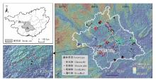
Fig.1
Location of study site in Guangxi, China and distribution of field plot"

Table 1
Summary of forest stand attributes of the field plot"
| 森林类型 Forest type | 样地数量 Sample size | 森林参数 Forest attribute | 均值 Mean | 最小值 Min. | 最大值 Max. | 标准差 St.dev. | 变动系数 CV(%) |
| 杉木林 Chinese fir | 84 | 林分年龄Age/a | 16.9 | 5.0 | 34.0 | 5.5 | 32.4 |
| 直径DBH/cm | 11.7 | 5.0 | 21.2 | 3.7 | 31.1 | ||
| 树高Height/m | 10.5 | 5.7 | 18.0 | 2.8 | 27.0 | ||
| 断面积Basal area(BA)/(m2·hm-2) | 30.2 | 12.8 | 48.6 | 7.5 | 24.9 | ||
| 蓄积量Stand volume(VOL)/(m3·hm-2) | 173.7 | 49.3 | 334.4 | 62.8 | 36.2 | ||
| 松树林 Masson pine | 97 | 林分年龄Age/a | 28.8 | 8.0 | 48.0 | 7.6 | 26.4 |
| 直径DBH/cm | 19.0 | 4.7 | 34.4 | 5.3 | 27.7 | ||
| 树高Height/m | 13.0 | 4.0 | 26.0 | 3.5 | 26.6 | ||
| 断面积Basal area(BA)/(m2·hm-2) | 26.7 | 5.0 | 53.5 | 8.5 | 32.0 | ||
| 蓄积量Stand volume(VOL)/(m3·hm-2) | 173.7 | 16.9 | 588.4 | 83.0 | 47.8 | ||
| 桉树林 Eucalyptus | 107 | 林分年龄Age/a | 4.5 | 2.0 | 9.0 | 1.5 | 34.3 |
| 直径DBH/cm | 11.4 | 2.0 | 18.0 | 2.2 | 19.4 | ||
| 树高Height/m | 16.3 | 9.8 | 25.1 | 2.7 | 16.6 | ||
| 断面积Basal area(BA)/(m2·hm-2) | 18.3 | 5.1 | 33.9 | 5.7 | 30.9 | ||
| 蓄积量Stand volume(VOL)/(m3·hm-2) | 150.1 | 31.8 | 266.8 | 58.1 | 38.7 | ||
| 阔叶林 Broadleaf | 95 | 林分年龄Age/a | 24.4 | 5.0 | 60.0 | 10.5 | 43.0 |
| 直径DBH/cm | 13.6 | 5.0 | 37.1 | 5.5 | 40.3 | ||
| 树高Height/m | 9.5 | 5.0 | 17.4 | 2.5 | 26.6 | ||
| 断面积Basal area(BA)/(m2·hm-2) | 17.6 | 1.6 | 44.3 | 8.6 | 48.7 | ||
| 蓄积量Stand volume(VOL)/(m3·hm-2) | 91.8 | 9.5 | 326.3 | 59.6 | 64.9 |
Table 2
Fitting results and statistics of the optimal and suboptimal models of three attributes estimation of four forest types"
| 森林类型 Forest type | 森林参数 Forest attribute | 模型编号 No. of model | 参数估计值Parameter estimates | R2 | rRMSE(%) | MPE(%) | |||||||
| a0 | Hmean | CC | LADcv | Hstdev | Hcv | dh50 | dh75 | ||||||
| 杉木林 Chinese fir | VOL | (8) | 9.826 6 | 1.413 0 | 0.771 0 | 0.158 3 | -0.387 8 | -0.033 3 | 0.726 | 18.80 | 4.21 | ||
| (9) | 9.230 5 | 1.036 3 | 0.802 9 | 0.117 9 | -0.441 0 | -0.174 0 | 0.733 | 18.57 | 4.16 | ||||
| BA | (8) | 3.863 4 | 1.079 6 | 0.383 5 | 0.008 0 | -0.576 8 | -0.074 2 | 0.570 | 16.25 | 3.64 | |||
| (9) | 3.689 5 | 0.515 3 | 0.465 4 | -0.080 2 | -0.663 5 | -0.316 0 | 0.620 | 15.28 | 3.42 | ||||
| DBH | (8) | 4.993 7 | 0.277 2 | 0.559 7 | -0.141 1 | 0.540 8 | 0.010 9 | 0.714 | 16.54 | 3.70 | |||
| (9) | 4.669 7 | 0.829 7 | 0.534 8 | -0.131 1 | 0.530 9 | 0.011 9 | 0.723 | 16.28 | 3.64 | ||||
| 松树林 Masson pine | VOL | (9) | 5.901 7 | 1.548 5 | -0.304 2 | -0.443 2 | 0.103 1 | 0.041 8 | 0.795 | 21.52 | 4.45 | ||
| (8) | 8.813 4 | 1.308 9 | -0.222 4 | -0.384 4 | 0.105 8 | 0.082 0 | 0.808 | 20.83 | 4.31 | ||||
| BA | (8) | 3.904 8 | 0.898 9 | -0.192 0 | -0.467 2 | 0.024 5 | 0.004 6 | 0.632 | 19.34 | 4.00 | |||
| (9) | 3.532 1 | 0.952 7 | -0.198 2 | -0.482 2 | 0.009 9 | -0.048 4 | 0.643 | 19.04 | 3.94 | ||||
| DBH | (8) | 5.816 2 | 0.351 9 | -0.119 5 | -0.092 0 | 0.294 6 | -0.026 4 | 0.471 | 20.05 | 4.15 | |||
| (9) | 8.390 3 | 0.543 2 | -0.089 7 | -0.060 1 | 0.349 3 | 0.100 0 | 0.489 | 19.71 | 4.08 | ||||
| 桉树林 Eucalyptus | VOL | (9) | 2.519 3 | 1.558 0 | 0.367 8 | 0.202 1 | 0.072 3 | -0.238 3 | 0.759 | 18.93 | 3.72 | ||
| (8) | 8.303 8 | 1.067 4 | 0.479 5 | 0.202 2 | 0.198 4 | 0.262 7 | 0.788 | 17.75 | 3.49 | ||||
| BA | (9) | 1.261 6 | 1.024 2 | 0.525 6 | 0.135 3 | -0.023 1 | -0.379 6 | 0.689 | 17.16 | 3.37 | |||
| (8) | 2.712 9 | 0.763 7 | 0.618 8 | 0.127 1 | 0.103 3 | 0.100 9 | 0.720 | 16.28 | 3.20 | ||||
| DBH | (8) | 1.315 7 | 0.675 3 | -0.135 0 | 0.175 2 | 0.112 2 | -0.064 5 | 0.707 | 10.48 | 2.06 | |||
| (9) | 1.022 9 | 0.826 2 | -0.122 2 | 0.166 6 | 0.020 2 | -0.401 8 | 0.708 | 10.46 | 2.05 | ||||
| 阔叶林 Broadleaf | VOL | (9) | 16.937 6 | 1.070 3 | 0.216 5 | 0.200 4 | 0.210 2 | 0.689 6 | 0.674 | 36.87 | 7.72 | ||
| (8) | 13.928 0 | 1.115 8 | 0.284 5 | 0.241 9 | -0.114 5 | 0.205 0 | 0.679 | 36.58 | 7.66 | ||||
| BA | (8) | 6.204 5 | 0.773 6 | 0.539 7 | 0.503 1 | -0.280 8 | 0.221 0 | 0.595 | 30.83 | 6.46 | |||
| (9) | 6.981 7 | 0.568 9 | 0.340 8 | 0.476 9 | 0.049 7 | 0.682 0 | 0.600 | 30.64 | 6.42 | ||||
| DBH | (7) | 4.941 0 | 0.818 0 | 0.024 8 | -0.222 0 | 0.528 9 | 0.396 | 31.11 | 6.47 | ||||
| (9) | 6.629 7 | 0.718 7 | 0.042 3 | -0.126 8 | 0.587 2 | 0.105 3 | 0.412 | 30.71 | 6.43 | ||||
Table 3
Significance t-test results of parameters of model(9) of three attributes of four forest types"
| LiDAR变量 LiDAR metric | 杉木林Chinese fir | 松树林Masson pine | 桉树林Eucalyptus | 阔叶林Broadleaf | |||||||||||
| VOL | BA | DBH | VOL | BA | DBH | VOL | BA | DBH | VOL | BA | DBH | ||||
| Hmean | 10.67*** | 6.92*** | 7.78*** | 10.68*** | 5.93*** | 4.10*** | 12.62*** | 9.82*** | 13.33*** | 5.91*** | 4.16*** | 2.99*** | |||
| CC | 5.57*** | 5.13*** | -0.21 | -0.34 | -0.15 | -0.95 | 2.53** | 2.59** | 1.01 | 0.19 | 1.90* | -0.87 | |||
| LADcv | 2.12** | 0.47 | 0.48 | -0.13 | 0.07 | 0.62 | 0.66 | 0.97 | -1.21 | -0.15 | -0.31 | 1.52 | |||
| Hcv | -4.22*** | -7.29*** | 5.84*** | 1.50 | 0.45 | 3.96*** | 3.23*** | 2.88*** | 4.03*** | -0.08 | -0.61 | 2.96*** | |||
| dh50 | -1.62 | -4.74*** | 1.90* | 2.50** | 2.45** | 1.68* | 1.69* | 2.07** | -1.14 | 1.73* | 1.67* | 1.35 | |||
Table 4
Relative error of fit statistics between model(9) and (8) and the locally optimal model of three attributes of four forest types %"
| 森林类型 Forest type | 森林参数 Forest attribute | 模型(9) Model (9) | 模型(8)Model (8) | |||||
| R2 | rRMSE | MPE | R2 | rRMSE | MPE | |||
| 杉木林 Chinese fir | VOL | — | — | — | -0.93 | 1.24 | 1.24 | |
| BA | — | — | — | -8.75 | 5.98 | 5.98 | ||
| DBH | — | — | — | -1.23 | 1.55 | 1.55 | ||
| 松树林 Masson pine | VOL | -1.61 | 3.33 | 3.33 | — | — | — | |
| BA | — | — | — | -1.83 | 1.58 | 1.58 | ||
| DBH | — | — | — | -3.88 | 1.74 | 1.74 | ||
| 桉树林 Eucalyptus | VOL | -3.70 | 6.65 | 6.65 | — | — | — | |
| BA | -4.32 | 5.41 | 5.41 | — | — | — | ||
| DBH | — | — | — | -0.18 | 0.22 | 0.22 | ||
| 阔叶林 Broadleaf | VOL | -0.77 | 0.81 | 0.81 | — | — | — | |
| BA | — | — | — | -0.84 | 0.62 | 0.62 | ||
| DBH | — | — | — | -17.19 | 4.78 | 4.78 | ||
Table 5
Validation results of model(9) and (8)"
| 森林类型 Forest type | 森林参数 Forest attribute | 模型(9)Model (9) | 模型(8)Model (8) | |||||
| R2 | rRMSE(%) | MPE(%) | R2 | rRMSE(%) | MPE(%) | |||
| 杉木林 Chinese fir | VOL | 0.667 | 20.89 | 4.22 | 0.677 | 20.58 | 4.16 | |
| BA | 0.572 | 16.15 | 3.27 | 0.591 | 15.80 | 3.19 | ||
| DBH | 0.574 | 18.56 | 3.75 | 0.554 | 19.00 | 3.84 | ||
| 松树林 Masson pine | VOL | 0.769 | 21.69 | 4.15 | 0.788 | 20.76 | 3.97 | |
| BA | 0.582 | 20.36 | 3.90 | 0.577 | 20.48 | 3.92 | ||
| DBH | 0.501 | 19.40 | 3.71 | 0.494 | 19.53 | 3.74 | ||
| 桉树林 Eucalyptus | VOL | 0.764 | 18.53 | 3.37 | 0.799 | 17.10 | 3.11 | |
| BA | 0.706 | 16.11 | 2.93 | 0.737 | 15.23 | 2.77 | ||
| DBH | 0.709 | 10.07 | 1.83 | 0.706 | 10.14 | 1.85 | ||
| 阔叶林 Broadleaf | VOL | 0.602 | 36.32 | 6.95 | 0.564 | 38.02 | 7.27 | |
| BA | 0.568 | 30.82 | 5.89 | 0.484 | 33.69 | 6.44 | ||
| DBH | 0.240 | 29.01 | 5.55 | 0.222 | 36.78 | 7.04 | ||

Fig.2
Observed versus predicted of VOL, BA and DBH of validation sample of four forest types of model(9) and (8)developed using ALS data"

| 刘浩, 张峥男, 曹林. 机载激光雷达森林垂直结构剖面参数的沿海平原人工林林分特征反演. 遥感学报, 2018, 22 (5): 872- 888. | |
| Liu H , Zhang Z N , Cao L . Estimating forest stand characteristics in a coastal plain forest plantation based on vertical structure profile parameters derived from ALS data. Journal of Remote Sensing, 2018, 22 (5): 872- 888. | |
| 骆期邦, 曾伟生, 贺东北. 林业数表模型——理论、方法与实践. 长沙: 湖南科学技术出版社, 2001: 7 | |
| Luo Q B , Zeng W S , He D B . Mathematical modeling for forestry table: theory, method and practice. Changsha: Science and Technology Press of Hunan, 2001: 7 | |
| 周梅, 李春干, 代华兵. 采用林分平均高和密度估计人工林蓄积量. 广西林业科学, 2017, 46 (3): 319- 324. | |
| Zhou M , Li C G , Dai H B . Estimation of stand volume based on stand average height and density of plantation. Guangxi Forestry Science, 2017, 46 (4): 319- 324. | |
|
Asner G P , Mascaro J , Muller-Landau H C , et al. A universal airborne LiDAR approach for tropical forest carbon mapping. Oecologia, 2012, 168 (4): 1147- 1160.
doi: 10.1007/s00442-011-2165-z |
|
|
Bouvier M , Durrieu S , Fournier R A , et al. Generalizing predictive models of forest inventory attributes using an area-based approach with airborne LiDAR data. Remote Sensing of Environment, 2015, 156, 322- 334.
doi: 10.1016/j.rse.2014.10.004 |
|
| Büyüksalih I, Bayburt S, Schardt M, et al. 2017. Forest stem volume calculation using airborne LiDAR data. The International Archives of the Photogrammetry, Remote Sensing and Spatial Information Sciences, Volume XLII-1/W1, 2017 ISPRS Hannover Workshop: HRIGI 17-CMRT 17-ISA 17-EuroCOW 17, 6-9 June 2017, Hannover, Germany. | |
|
Chave J , Condit R , Aguilar S , et al. Error propagation and scaling for tropical forest biomass estimates. Philosophical Transactions of the Royal Society of London Series B, Biological Sciences, 2004, 359 (1443): 409- 420.
doi: 10.1098/rstb.2003.1425 |
|
|
Chen Q , Laurin G V , Battles J J , et al. Integration of airborne LiDAR and vegetation types derived from aerial photography for mapping aboveground live biomass. Remote Sensing of Environment, 2012, 121, 108- 117.
doi: 10.1016/j.rse.2012.01.021 |
|
| Chubey M S , Franklin S E , Wulder M A . Object-based analysis of Ikonos-2 imagery for extraction of forest Inventory parameters. Photogrammetric Engineering & Remote Sensing, 2006, 72 (4): 383- 394. | |
|
Clark D B , Kellner J R . Tropical forest biomass estimation and the fallacy of misplaced concreteness. Journal of Vegetation Science, 2012, 23 (6): 1191- 1196.
doi: 10.1111/j.1654-1103.2012.01471.x |
|
|
Coops N C , Wulder M A , Culvenor D S , et al. Comparison of forest attributes extracted from fine spatial resolution multispectral and LiDAR data. Canadian Journal of Remote Sensing, 2004, 30 (6): 855- 866.
doi: 10.5589/m04-045 |
|
|
Dube T , Sibanda M , Shoko C , et al. Stand-volume estimation from multi-source data for coppiced and high forest Eucalyptus. silvicultural systems in KwaZulu-Natal, South Africa. ISPRS Journal of Photogrammetry and Remote Sensing, 2017, 132, 162- 169.
doi: 10.1016/j.isprsjprs.2017.09.001 |
|
|
Falkowski M J , Smith A M S , Gessler P E , et al. The influence of conifer forest canopy cover on the accuracy of two individual tree measurement algorithms using LiDAR data. Canadian Journal of Remote Sensing, 2008, 34 (Sup2): S338- S350.
doi: 10.5589/m08-055 |
|
|
Falkowski M J , Smith A M S , Hudak A T , et al. Automated estimation of individual conifer tree height and crown diameter two-dimensional spatial wavelet analysis of LiDAR data. Canadian Journal of Remote Sensing, 2006, 32 (2): 153- 161.
doi: 10.5589/m06-005 |
|
|
Fekety P A , Falkowski M J , Hudak A . Temporal transferability of LiDAR-based imputation of forest inventory attributes. Canadian Journal of Forest Research, 2015, 45 (4): 422- 435.
doi: 10.1139/cjfr-2014-0405 |
|
|
Giannico V , Lafortezza R , John R , et al. Estimating stand volume and above-ground biomass of urban forests using LiDAR. Remote Sensing, 2016, 8, 339.
doi: 10.3390/rs8040339 |
|
|
Görgens E B , Packalen P , Silva A G P , et al. Stand volume models based on stable metrics as from multiple ALS acquisitions in Eucalyptus plantations. Annals of Forest Science, 2015, 72 (4): 489- 498.
doi: 10.1007/s13595-015-0457-x |
|
|
Hopkinson C , Lovell J , Chasmer L , et al. Integrating terrestrial and airborne LiDAR to calibrate a 3D canopy model of effective leaf area index. Remote Sensing of Environment, 2013, 136, 301- 314.
doi: 10.1016/j.rse.2013.05.012 |
|
| Hyyppä J , Yu X , Rönnholm P , et al. Factors affecting laser-derived object-oriented forest height growth estimation. The Photogrammetric Journal of Finland, 2003, 18 (2): 16- 31. | |
|
Jakubowski M K , Guo Q , Collins B , et al. Predicting surface fuel models and fuel metrics using LiDAR and imagery in dense, mountainous forest. Photogrammetric Engineering and Remote Sensing, 2013, 79, 37- 49.
doi: 10.14358/PERS.79.1.37 |
|
|
Johnson K D , Birdsey R , Finley A O , et al. Integrating forest inventory and analysis data into a LiDAR-based carbon monitoring system. Carbon Balance and Management, 2014, 9, 3.
doi: 10.1186/1750-0680-9-3 |
|
|
Kaartinen H , Hyyppä J , Yu X , et al. An international comparison of individual tree detection and extraction using airborne laser scanning. Remote Sensing, 2012, 4, 950- 974.
doi: 10.3390/rs4040950 |
|
|
Kauranne T , Pyankov S , Junttila V , et al. Airborne laser scanning based forest inventory: comparison of experimental results for the Perm region, Russia and prior results from Finland. Forests, 2017, 8, 72.
doi: 10.3390/f8030072 |
|
|
Kim E , Lee W K , Yoon M , et al. Estimation of voxel based above-ground biomass using airborne LiDAR data in an intact tropical rain forest, Brunei. Forests, 2016, 7, 259.
doi: 10.3390/f7110259 |
|
|
Knapp N , Fischer R , Cazcarra-Bes V , et al. Structure metrics to generalize biomass estimation from LiDAR across forest types from different continents. Remote Sensing of Environment, 2020, 237, 111597.
doi: 10.1016/j.rse.2019.111597 |
|
| Koch B, Kattenborn T, Straub C, et al. 2014. Segmentation of forest to tree objects//Maltamo M, Næsset E, Vauhkonen J. Forestry applications of airborne laser scanning: concepts and case studies, managing forest ecosystems 27. Springer Science C Business Media Dordrecht, 89-112. | |
|
Latifi H , Fabian E , Fassnacht F E , et al. Forest inventories by LiDAR data: a comparison of single tree segmentation and metric-based methods for inventories of a heterogeneous temperate forest. International Journal of Applied Earth Observation and Geoinformation, 2015, 42, 162- 174.
doi: 10.1016/j.jag.2015.06.008 |
|
|
Leboeuf A , Fournier R A , Luther J E , et al. Forest attribute estimation of northeastern Canadian forests using QuickBird imagery and a shadow fraction method. Forest Ecology and Management, 2012, 266, 66- 74.
doi: 10.1016/j.foreco.2011.11.008 |
|
|
Lefsky M A , Cohen W B , Spies T A . An evaluation of alternate remote sensing products for forest inventory, monitoring, and mapping of Douglas-fir forests in western Oregon. Canadian Journal of Forest Research, 2001, 31, 78- 87.
doi: 10.1139/x00-142 |
|
|
Li D , Guo H , Wang C , et al. Individual tree delineation in windbreaks using airborne-laser-scanning data and unmanned aerial vehicle stereo images. IEEE Geoscience and Remote Sensing Letters, 2016, 13 (9): 1330- 1334.
doi: 10.1109/LGRS.2016.2584109 |
|
|
Li W , Guo Q , Jakubowski M , et al. A new method for segmenting individual trees from the LiDAR point cloud. Photogrammetric Engineering and Remote Sensing, 2012, 78, 75- 84.
doi: 10.14358/PERS.78.1.75 |
|
|
Lovell J L , Jupp D L B , Culvenor D S , et al. Using airborne and ground-based ranging LiDAR to measure canopy structure in Australian forests. Canadian Journal of Remote Sensing, 2003, 29 (5): 607- 622.
doi: 10.5589/m03-026 |
|
|
Maltamo M , Bollandsas O M , Gobakken T , et al. Large-scale prediction of aboveground biomass in heterogeneous mountain forests by means of airborne laser scanning. Canadian Journal of Forest Research, 2016, 46, 1138- 1144.
doi: 10.1139/cjfr-2016-0086 |
|
|
Maltamo M , Malinen J , Packalén P , et al. Nonparametric estimation of stem volume using airborne laser scanning, aerial photography, and stand-register data. Canadian Journal of Forest Research, 2006, 36, 426- 436.
doi: 10.1139/x05-246 |
|
| Maltamo M, Packalen P. 2014. Species-specific management inventory in Finland//Maltamo M, Næsset E, Vauhkonen J. Forestry applications of airborne laser scanning: concepts and case studies, managing forest ecosystems 27. Springer Science C Business Media Dordrecht, 241-252. | |
|
Matasci G , Hermosilla T , Wulder M A , et al. Large-area mapping of Canadian boreal forest cover, height, biomass and other structural attributes using Landsat composites and LiDAR plots. Remote Sensing of Environment, 2018, 209, 90- 106.
doi: 10.1016/j.rse.2017.12.020 |
|
|
McRoberts R E , Tomppo E O , Næsset E . Advances and emerging issues in national forest inventories. Scandinavian Journal of Forest Research, 2010, 25 (4): 368- 381.
doi: 10.1080/02827581.2010.496739 |
|
|
Montaghi A , Corona P , Dalponte M , et al. Airborne laser scanning of forest resources: an overview of research in Italy as a commentary case study. International Journal of Applied Earth Observation and Geoinformation, 2013, 23, 288- 300.
doi: 10.1016/j.jag.2012.10.002 |
|
|
Montealegre A L , Lamelas M T , de la Riva J , et al. Use of low point density ALS data to estimate stand-level structural variables in Mediterranean Aleppo pine forest. Forestry: An International Journal of Forest Research, 2016, 89 (4): 373- 382.
doi: 10.1093/forestry/cpw008 |
|
| Næsset E. 2015. Area-based inventory in Norway-from innovation to an operational reality//Maltamo M, Næsset E, Vauhkonen J. Forestry applications of airborne laser scanning: concepts and case studies, managing forest ecosystems 27. Springer Science C Business Media Dordrecht, 215-240. | |
|
Nelson R , Short A , Valenti M . Measuring biomass and carbon in Delaware using an airborne profiling LIDAR. Scandinavian Journal of Forest Research, 2004, 19 (6): 500- 511.
doi: 10.1080/02827580410019508 |
|
|
Pearse G D , Dash J P , Persson H J , et al. Comparison of high-density LiDAR and satellite photogrammetry for forest inventory. ISPRS Journal of Photogrammetry and Remote Sensing, 2018, 142, 257- 267.
doi: 10.1016/j.isprsjprs.2018.06.006 |
|
| Persson Å , Holmgren J , Söderman U . Detecting and measuring individual trees using an airborne laser scanner. Photogrammetric Engineering and Remote Sensing, 2002, 68 (9): 925- 932. | |
| Popescu S C, Hauglin M. 2014. Estimation of biomass components by airborne laser scanning//Maltamo M, Næsset E, Vauhkonen J. Forestry applications of airborne laser scanning: concepts and case studies, managing forest ecosystems 27. Springer Science C Business Media Dordrecht, 157-175. | |
|
Popescu S C , Wynne R H , Nelson R F . Measuring individual tree crown diameter with LiDAR and assessing its influence on estimating forest volume and biomass. Canadian Journal of Remote Sensing, 2003, 29 (5): 564- 577.
doi: 10.5589/m03-027 |
|
|
Silva C A , Hudak A T , Klauberg C , et al. Combined effect of pulse density and grid cell size on predicting and mapping aboveground carbon in fast-growing Eucalyptus forest plantation using airborne LiDAR data. Carbon Balance and Management, 2017, 12 (1): 13.
doi: 10.1186/s13021-017-0081-1 |
|
|
Silva C A , Klauberg C , Hubdak A T , et al. Modeling and mapping basal area of Pinus taeda L. plantation using airborne LiDAR data. Annals of the Brazilian Academy of Sciences, 2017, 89 (3): 1895- 1905.
doi: 10.1590/0001-3765201720160324 |
|
|
Singh K , Chen G , Vogler J B , et al. When big data are too much: effects of LiDAR returns and point density on estimation of forest biomass. IEEE Journal of Selected Topics in Applied Earth Observations and Remote Sensing, 2016, 9 (7): 3210- 3218.
doi: 10.1109/JSTARS.2016.2522960 |
|
|
Straub C , Tian J J , Seitz R , et al. Assessment of Cartosat-1 and WorldView-2 stereo imagery in combination with a LiDAR-DTM for timber volume estimation in a highly structured forest in Germany. Forestry: An International Journal of Forest Research, 2013, 86 (4): 463- 473.
doi: 10.1093/forestry/cpt017 |
|
|
Tonolli S , Dalponte M , Neteler M , et al. Fusion of airborne LiDAR and satellite multispectral data for the estimation of timber volume in the Southern Alps. Remote Sensing of Environment, 2011, 115, 2486- 2498.
doi: 10.1016/j.rse.2011.05.009 |
|
|
Vauhkonen J , Ene L , Gupta S , et al. Comparative testing of single-tree detection algorithms under different types of forest. Forestry: An International Journal of Forest Research, 2012, 85 (1): 27- 40.
doi: 10.1093/forestry/cpr051 |
|
| Vauhkonen J, Maltamo M, McRoberts R E, et al. 2014. Introduction to forestry applications of airborne laser scanning//Maltamo M, Næsset E, Vauhkonen J. Forestry applications of airborne laser scanning: concepts and case studies, managing forest ecosystems 27. Springer Science C Business Media Dordrecht, 1-16. | |
|
Watt P , Watt M S . Development of a national model of Pinus radiata stand volume from LiDAR metrics for New Zealand. International Journal of Remote Sensing, 2013, 34 (16): 5892- 5904.
doi: 10.1080/01431161.2013.798053 |
|
|
Xu C , Manley B , Morgenroth J . Evaluation of modeling approaches in predicting forest volume and stand age for small-scale plantation forests in New Zealand with RapidEye and LiDAR. International Journal of Applied Earth Observation and Geoinformation, 2018, 73, 386- 396.
doi: 10.1016/j.jag.2018.06.021 |
|
|
Zeng W S , Duo H R , Lei X D , et al. Individual tree biomass equations and growth models sensitive to climate variables for Larix spp. in China. European Journal of Forest Research, 2017, 136 (2): 233- 249.
doi: 10.1007/s10342-017-1024-9 |
|
|
Zeng W S , Fu L Y , Xu M , et al. Developing individual tree-based models for estimating aboveground biomass of five key coniferous species in China. Journal of Forest Research, 2018, 29 (5): 1251- 1261.
doi: 10.1007/s11676-017-0538-9 |
|
|
Zolkos S G , Goetz S J , Dubayah R . A meta-analysis of terrestrial aboveground biomass estimation using LiDAR remote sensing. Remote Sensing of Environment, 2013, 128, 289- 298.
doi: 10.1016/j.rse.2012.10.017 |
| Viewed | ||||||
|
Full text |
|
|||||
|
Abstract |
|
|||||