
Scientia Silvae Sinicae ›› 2025, Vol. 61 ›› Issue (7): 208-219.doi: 10.11707/j.1001-7488.LYKX20250184
• Research papers • Previous Articles Next Articles
Sisi Yu1,2,Shangshu Cai3,4,Shengrui Zhang5,Jiacheng Huang6,7,Kun Jin1,2,*( )
)
Received:2025-03-31
Online:2025-07-20
Published:2025-07-25
Contact:
Kun Jin
E-mail:jk2002@caf.ac.cn
CLC Number:
Sisi Yu,Shangshu Cai,Shengrui Zhang,Jiacheng Huang,Kun Jin. Evolution and Multi-Scenario Prediction of Land Habitat Quality in the Potential Area of the Proposed Songnen Plain Crane Homeland National Park[J]. Scientia Silvae Sinicae, 2025, 61(7): 208-219.
Table 1
Data source"
| 类别 Category | 名称 Name | 年份 Year | 来源 Source |
| 土地 Land | 土地利用类型 Land use type | 1990、2005、2020 | 资源环境科学数据平台 Resource and Environmental Science Data Platform( |
| 土壤 Soil | 砂粒含量 Sand content | 2009 | 联合国粮食及农业组织 Food and Agriculture Organization of the United Nations( |
| 粉粒含量 Silt content | 2009 | ||
| 黏粒含量 Clay content | 2009 | ||
| 气候 Climate | 多年平均降水量 Multi-year average precipitation | 2005—2020 | 国家地球系统科学数据中心 National Earth System Science Data Center( |
| 多年月均气温 Multi-year month mean temperature | 2005—2020 | ||
| 多年月均蒸散发量 Multi-year month mean evapotranspiration | 2005—2020 | ||
| 地形 Terrain | 高程 Elevation | 2000 | NASADEM V001产品(2020年) NASADEM V001 products (the year 2020) |
| 坡度 Slope | 2000 | ||
| 基础地理 Basic geography | 距国省县道的距离 Distance to national, provincial and county roads | 2019 | 1∶100万公众版基础地理信息数据(2021年)1∶1 000 000 public version basic geographic information data (the year 2021),全国地理信息资源目录服务系统 National Catalogue Service For Geographic Information( |
| 距高速公路的距离 Distance to highway | 2019 | ||
| 距铁路的距离 Distance to railway | 2019 | ||
| 距县政府的距离 Distance to county government | 2019 | ||
| 距乡政府的距离 Distance to township government | 2019 | ||
| 距村政府的距离 Distance to village government | 2019 | ||
| 距水系的距离 Distance to water system | 2019 | ||
| 道路网密度 Road density | 2019 | ||
| 铁路网密度 Railway density | 2019 | ||
| 社会经济 Social economy | 人口密度 Population density | 2020 | 世界人口中心共享平台 World Population Center Sharing Platform( |
| 人类足迹 Human footprint | 2020 |
Table 2
Future scenario description and parameter setting"
| 项目Item | 自然发展 Natural development | 城镇发展 Urban development | 耕地保护 Cropland protection | 生态保护 Ecological protection |
| 描述 Description | 重视历史发展规律,保持历史演变趋势:基于2005—2020年土地利用演变规律,假设未来15年土地利用发展不受干扰,预测2035年土地利用情况 Emphasizing the laws of historical development and maintaining the trend of historical evolution: based on the law of land use evolution from 2005 to 2020, it is assumed that land use development will not be disturbed in the next 15 years, and the land use situation in 2035 is predicted | 重视城镇发展,加大对城镇建设的投入:耕、林、草地向建设用地转移的概率增加20%,建设用地向其他地类 (耕地除外)转移的概率降低30% Emphasizing urban development and increasing investment in urban construction: the probability of cropland, forest, and grassland being converted to construction land increases by 20%, and the probability of construction land being converted to other land types (excluding cropland) decreases by 30% | 以保障国家18亿亩耕地红线为导向,防止城镇建设和生态保护措施占用耕地:在自然发展的基础上,耕地向建设用地转移的概率降低60% Taking the protection of the national 1.8 billion mu of cropland red line as the orientation, and preventing the occupation of cropland by urban construction and ecological protection measures: on the basis of natural development, the probability of cropland being converted to construction land decreases by 60% | 保护生态系统,促进人与自然和谐共生:林、草地向建设用地转移的概率降低50%,耕地向建设用地转移的概率降低30%,耕地向林地转移的概率提高30% Protecting the ecosystem and promoting harmonious coexistence between humans and nature: the probability of forest and grassland being converted to construction land decreases by 50%, the probability of cropland being converted to construction land decreases by 30%, and the probability of cropland being converted to forest increases by 30% |
| 转移矩阵 Transition matrix | ||||
| 邻域权重 Neighborhood weight | 耕地Cropland 0.329,林地Forest 0.180,草地Grassland 0.164,水域Water area 0.049, 建设用地Construction land 0.117,裸地Bare land 0.059,湿地Wetland 0.102 | |||
Table 3
Parameter settings related to the habitat quality module"
| 威胁因素 Threat factor | 影响距离 Impact distance/km | 权重 Weight | 衰减函数类型 Decay type | 土地利用类型 Land use type | ||||||
| 耕地 Cropland | 林地 Forest | 草地 Grassland | 水域 Water area | 建设用地 Construction land | 裸地 Bare land | 湿地 Wetland | ||||
| 0.40* | 1.00* | 0.80* | 0.70* | 0.00* | 0.10* | 0.70* | ||||
| 耕地 Cropland | 4 | 0.60 | 线性 Linear | 0.20# | 0.50# | 0.20# | 0.40# | 0.00# | 0.10# | 0.55# |
| 裸地 Bare land | 6 | 0.50 | 线性 Linear | 0.90# | 0.80# | 0.50# | 0.60# | 0.00# | 0.30# | 0.70# |
| 建设用地 Construction land | 8 | 0.80 | 指数 Exponential | 0.40# | 0.20# | 0.30# | 0.50# | 0.00# | 0.20# | 0.30# |
Table 4
Area statistics of land use types in the study area from 1990 to 2020 km2"
| 年份 Year | 耕地 Cropland | 林地 Forest | 草地 Grassland | 水域 Water area | 建设用地 Construction land | 裸地 Bare land | 湿地 Wetland |
| 1990 | 157 864.01 | 135 600.01 | 72 167.48 | 7 427.62 | 11 842.91 | 14 878.32 | 29 594.25 |
| 2005 | 176 510.01 | 128 250.72 | 64 452.41 | 6 081.42 | 12 187.15 | 14 942.21 | 26 950.68 |
| 2020 | 176 611.27 | 128 414.44 | 63 024.38 | 6 370.73 | 13 519.32 | 14 512.65 | 26 921.81 |
Table 5
Area statistics of land use type in the study area by 2035 under multiple future scenarios km2"
| 情景 Scenarios | 耕地 Cropland | 林地 Forest | 草地 Grassland | 水域 Water area | 建设用地 Construction land | 裸地 Bare land | 湿地 Wetland |
| 自然发展 Natural development | 176 817.94 | 128 551.34 | 61 719.59 | 6 604.18 | 14 642.12 | 14 135.61 | 26 903.82 |
| 城镇发展 Urban development | 176 320.36 | 128 497.97 | 61 658.54 | 6 597.83 | 15 279.34 | 14 126.07 | 26 894.49 |
| 耕地保护 Cropland protection | 178 326.79 | 128 576.76 | 61 734.58 | 6 470.18 | 13 214.49 | 14 139.09 | 26 912.71 |
| 生态保护 Ecological protection | 175 988.48 | 128 944.35 | 63 460.91 | 6 422.10 | 13 353.08 | 14 136.77 | 27 068.91 |
Table 6
Area statistics of habitat quality grades in the study area from 1990 to 2020 km2"
| 年份 Year | 核心生态栖息地 Core ecological habitat | 适宜生态栖息地 Suitable ecological habitat | 过渡生态区 Transitional ecological area | 不适宜栖息地 Unsuitable habitat | 受损生态区 Damaged ecological area |
| 1990 | 104 496.57 | 69 266.15 | 38 357.79 | 140 902.05 | 76 352.04 |
| 2005 | 92 668.59 | 67 918.88 | 34 258.77 | 152 176.98 | 82 351.38 |
| 2020 | 90 099.55 | 68 177.19 | 33 918.31 | 149 661.54 | 87 518.01 |
Table 7
Area statistics of habitat quality grades in the study area by 2035 under multiple future scenarios km2"
| 情景 Scenario | 核心生态栖息地 Core ecological habitat | 适宜生态栖息地 Suitable ecological habitat | 过渡生态区 Transitional ecological area | 不适宜栖息地 Unsuitable habitat | 受损生态区 Damaged ecological area |
| 自然发展Natural development | 89 895.57 | 67 726.34 | 33 687.20 | 149 741.03 | 88 324.46 |
| 城镇发展 Urban development | 89 821.73 | 67 630.72 | 33 516.71 | 149 658.64 | 88 746.80 |
| 耕地保护 Cropland protection | 89 788.47 | 67 772.10 | 33 587.66 | 150 839.30 | 87 387.07 |
| 生态保护 Ecological protection | 90 204.01 | 68 551.43 | 34 227.94 | 149 388.74 | 87 002.48 |
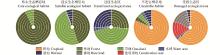
Fig.1
Area proportions of land use types within each habitat quality grade in the study area from 1990 to 2035 Inner Ring to Outer Ring: 1990, 2005, 2020, natural development, urban development, cropland protection, and ecological protection scenarios."
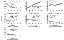
Fig.2
Response of habitat quality evolution to land use changes"
| 黄晗雯, 刘 洋, 陈君帜, 等. 拟建松嫩鹤乡国家公园范围划定方法探讨. 风景园林, 2022, 29 (7): 26- 29. | |
| Huang H W, Liu Y, Chen J Z, et al. Discussion on scope demarcation methods for the proposed Songnen Plain Crane Homeland National Park. Landscape Architecture, 2022, 29 (7): 26- 29. | |
|
匡文慧, 张树文, 杜国明, 等. 2015—2020年中国土地利用变化遥感制图及时空特征分析. 地理学报, 2022, 77 (5): 1056- 1071.
doi: 10.11821/dlxb202205002 |
|
|
Kuang W H, Zhang S W, Du G M, et al. Remotely sensed mapping and analysis of spatio-temporal patterns of land use change across China in 2015—2020. Acta Geographica Sinica, 2022, 77 (5): 1056- 1071.
doi: 10.11821/dlxb202205002 |
|
| 李玉恒, 赵 宁, 张 云, 等. 2025. 东北黑土区土地生境质量演化及多情景预测: 以黑龙江省为例. 环境科学, 1−21. https://doi.org/10.13227/j.hjkx.202409094. | |
| Li Y H, Zhao Y, Zhang Y, et al. 2025. Evolution in land-habitat in black soil area of Northeast China and Multi-scenario forecasting: the study of Heilongjiang Province. Environmental Science, 1−21. https://doi.org/10.13227/j.hjkx.202409094.[in Chinese] | |
|
刘晓菡, 乔秀娟. 大熊猫国家公园秦岭片区生境质量时空变化特征研究. 西北林学院学报, 2024, 39 (3): 179- 188.
doi: 10.3969/j.issn.1001-7461.2024.03.23 |
|
|
Liu X H, Qiao X J. Spatio-temporal variation of habitat quality of the Giant Panda National Park in the Qinling Area, China. Journal of Northwest Forestry University, 2024, 39 (3): 179- 188.
doi: 10.3969/j.issn.1001-7461.2024.03.23 |
|
| 刘晓辉, 姜 明, 吕宪国, 等. 拟建松嫩鹤乡国家公园范围划定与管理的思考. 国家公园(中英文), 2023, 1 (2): 110- 115. | |
| Liu X H, Jiang M, Lü X G, et al. Pondering on scope and management of the proposed Songnen Plain Crane Homeland National Park. National Park, 2023, 1 (2): 110- 115. | |
|
孙乔昀, 鲍梦涵, 黄晗雯, 等. 拟建松嫩平原国家公园边界划定研究. 北京林业大学学报, 2022, 44 (1): 103- 112.
doi: 10.12171/j.1000-1522.20210418 |
|
|
Sun Q Y, Bao M H, Huang H W, et al. Boundary delimitation of the proposed Songnen Plain National Park of northeastern China. Journal of Beijing Forestry University, 2022, 44 (1): 103- 112.
doi: 10.12171/j.1000-1522.20210418 |
|
| 唐小平, 欧阳志云, 蒋亚芳, 等. 中国国家公园空间布局研究. 国家公园(中英文), 2023, 1 (1): 1- 10. | |
| Tang X P, Ouyang Z Y, Jiang Y F, et al. Spatial planning of national parks in China. National Park, 2023, 1 (1): 1- 10. | |
|
魏天宇. 松嫩平原湿地水资源初探及建议. 水利科技与经济, 2004, 10 (6): 352- 353.
doi: 10.3969/j.issn.1006-7175.2004.06.015 |
|
|
Wei T Y. Preliminary study and suggestion on water resources in Songnen Plain wetland. Water Conservancy Science and Technology and Economy, 2004, 10 (6): 352- 353.
doi: 10.3969/j.issn.1006-7175.2004.06.015 |
|
|
吴林霖, 王思远, 杨瑞霞, 等. 斯里兰卡亚洲象栖息地生境质量时空变化及分异特征. 遥感学报, 2021, 25 (12): 2472- 2487.
doi: 10.11834/j.issn.1007-4619.2021.12.ygxb202112012 |
|
|
Wu L L, Wang S Y, Yang R X, et al. Spatio-temporal patterns and differentiations of habitat quality for Asian elephant (Elephas maximus) habitat of Sri Lanka. National Remote Sensing Bulletin, 2021, 25 (12): 2472- 2487.
doi: 10.11834/j.issn.1007-4619.2021.12.ygxb202112012 |
|
| 杨 永, 李瑞红, 刘 航, 等. 东北农林交错区生境质量时空演变及归因分析. 生态学杂志, 2024, 43 (5): 1399- 1407. | |
| Yang Y, Li R H, Liu H, et al. Spatiotemporal evolution and driving forces of habitat quality in agroforestry ecotone of Northeast China. Chinese Journal of Ecology, 2024, 43 (5): 1399- 1407. | |
| 杨晓英, 马旭燕, 张富玲, 等. 基于InVEST模型的三江源国家公园黄河源园区生境质量时空变化分析. 河南城建学院学报, 2025, 34 (1): 98- 106. | |
| Yang X Y, Ma X Y, Zhang F L, et al. Analysis of temporal and spatial changes in habitat quality in the Yellow River Source Area of Sangjiangyuan National Park based on the InVEST model. Journal of Henan University of Urban Construction, 2025, 34 (1): 98- 106. | |
|
禹丝思, 孙中昶, 郭华东, 等. 海上丝绸之路超大城市空间扩展遥感监测与分析. 遥感学报, 2017, 21 (2): 169- 181.
doi: 10.11834/jrs.20176031 |
|
|
Yu S S, Sun Z C, Guo H D, et al. Monitoring and analyzing the spatial dynamics and patterns of megacities along the Maritime Silk Road. Journal of Remote Sensing, 2017, 21 (2): 169- 181.
doi: 10.11834/jrs.20176031 |
|
| 岳文泽, 夏皓轩, 吴 桐, 等. 浙江省生境质量时空演变与生态红线评估. 生态学报, 2022, 42 (15): 6406- 6417. | |
| Yue W Z, Xia H X, Wu T, et al. Spatio-temporal evolution of habitat quality and ecological red line assessment in Zhejiang Province. Acta Ecologica Sinica, 2022, 42 (15): 6406- 6417. | |
| 钟林生, 徐琳琳, 迟 磊. 中国国家公园生态旅游定位与发展路径. 国家公园(中英文), 2024, 2 (11): 723- 731. | |
| Zhong L S, Xu L L, Chi L. The positioning and development pathways of ecotourism in China’s national parks. National Park, 2024, 2 (11): 723- 731. | |
|
Huang J, Yu S, Githaiga K B, et al. Integrating seasonal variation into conservation planning can provide extra benefits: s case study in the Tana River Basin, Kenya. Ecological Indicators, 2025, 173, 113392.
doi: 10.1016/j.ecolind.2025.113392 |
|
|
Huang Y, Wu J. Spatial and temporal driving mechanisms of ecosystem service trade-off/synergy in national key urban agglomerations: a case study of the Yangtze River Delta urban agglomeration in China. Ecological Indicators, 2023, 154, 110800.
doi: 10.1016/j.ecolind.2023.110800 |
|
|
Kang X, Du M, Zhao L, et al. Integrity-centered framework for determining protected areas boundary: an application in the China’s national park. Ecological Informatics, 2024, 84, 102885.
doi: 10.1016/j.ecoinf.2024.102885 |
|
|
Li C, Connor T, Bai W, et al. Dynamics of the giant panda habitat suitability in response to changing anthropogenic disturbance in the Liangshan Mountains. Biological Conservation, 2019, 237, 445- 455.
doi: 10.1016/j.biocon.2019.07.018 |
|
|
Liang X, Guan Q F, Clarke K C, et al. Mixed-cell cellular automata: a new approach for simulating the spatio-temporal dynamics of mixed land use structures. Landscape and Urban Planning, 2021, 205, 103960.
doi: 10.1016/j.landurbplan.2020.103960 |
|
|
Ma B, Zeng W, Xie Y, et al. Boundary delineation and grading functional zoning of Sangjiangyuan National Park based on biodiversity importance evaluations. Science of the Total Environment, 2022, 825, 154068.
doi: 10.1016/j.scitotenv.2022.154068 |
|
| Mu H, Li X, Wen Y, et al. 2022. A global record of annual terrestrial human footprint dataset from 2000 to 2018. Scientific Data, 9: 176. | |
|
Sui L, Yan Z, Li K, et al. Prediction of ecological security network in Northeast China based on landscape ecological risk. Ecological Indicators, 2024, 160, 111783.
doi: 10.1016/j.ecolind.2024.111783 |
|
|
Tang F, Fu M, Wang L, et al. Land-use change in Changli County, China: predicting its spatio-temporal evolution in habitat quality. Ecological Indicators, 2020, 117, 106719.
doi: 10.1016/j.ecolind.2020.106719 |
|
| Tang J, Zhou L, Dang X, et al. , 2023 Impacts and predictions of urban expansion on habitat quality in the densely populated areas: a case study of the Yellow River Basin, China. Ecological Indicators, 151: 110320. | |
|
Wang H, Zhang C, Yao X, et al. Scenario simulation of the tradeoff between ecological and farmland in black soil region of Northeast China. Land Use Policy, 2022, 114, 105991.
doi: 10.1016/j.landusepol.2022.105991 |
|
|
Wang L, Jia D. Spatiotemporal analysis of habitat quality and driving factors in the middle reaches of the Yellow River Basin. Environmental Monitoring and Assessment, 2025, 197 (4): 386.
doi: 10.1007/s10661-025-13828-7 |
|
| Xu W, Pimm S L, Du A, et al. Transforming protected area management in China. Trends in Ecology & Evolution, 2019, 34 (9): 762- 766. |
| Viewed | ||||||
|
Full text |
|
|||||
|
Abstract |
|
|||||