
Scientia Silvae Sinicae ›› 2024, Vol. 60 ›› Issue (1): 19-31.doi: 10.11707/j.1001-7488.LYKX20230208
Previous Articles Next Articles
Xinsheng Han1,2,Guangquan Liu1,*( ),Hao Xu2,Liguo Dong2,Yongzhong Guo2,Yu An2,Haixia Wan2,Yueling Wang2
Received:2023-05-17
Online:2024-01-25
Published:2024-01-29
Contact:
Guangquan Liu
E-mail:.gqliu@iwhr.com
CLC Number:
Xinsheng Han,Guangquan Liu,Hao Xu,Liguo Dong,Yongzhong Guo,Yu An,Haixia Wan,Yueling Wang. Spatial Variation and Scale Effect of Surface Soil Organic Carbon Content on Typical Slopes in the Loess Region, Ningxia[J]. Scientia Silvae Sinicae, 2024, 60(1): 19-31.
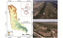
Fig.1
Locations of the study slopes"
Table 1
The basic information of slopes and sample points"
| 样点 Sample point | 东坡East slope | 西坡West slope | 南坡South slope | ||||||||
| 离坡顶水平距离 Horizontal distance from slope top/m | 立地类型 Site type | 主要植被 Main vegetation | 离坡顶水平距离 Horizontal distance from slope top/m | 立地类型 Site type | 主要植被 Main vegetation | 离坡顶水平距离 Horizontal distance from slope top/m | 立地类型 Site type | 主要植被 Main vegetation | |||
| 1 | 5.8 | A | a | 6.8 | A | b | 3.9 | A | b | ||
| 2 | 15.1 | A | a | 14.1 | A | b | 14.4 | A | b | ||
| 3 | 20.5 | A | a | 21.9 | A | b | 25.0 | A | b | ||
| 4 | 30.6 | A | a | 28.8 | A | b | 37.1 | A | b | ||
| 5 | 36.0 | A | a | 38.0 | A | b | 44.1 | A | b | ||
| 6 | 41.2 | A | a | 45.3 | A | b | 53.3 | A | b | ||
| 7 | 52.5 | A | a | 50.8 | A | b | 67.3 | A | b | ||
| 8 | 60.8 | A | a | 57.0 | A | b | 80.0 | A | b | ||
| 9 | 68.8 | A | a | 63.2 | A | b | 91.8 | A | b | ||
| 10 | 77.5 | A | a | 73.2 | A | b | 113.8 | A | b | ||
| 11 | 87.0 | A | b | 82.0 | A | b | 130.8 | A | a | ||
| 12 | 95.1 | A | b | 90.0 | A | b | 138.8 | A | a | ||
| 13 | 104.7 | A | b | 96.2 | A | b | 143.5 | A | a | ||
| 14 | 117.5 | A | b | 106.3 | B | d | 150.7 | A | a | ||
| 15 | 129.9 | A | b | 117.8 | B | d | 154.3 | A | a | ||
| 16 | 144.5 | A | a | 132.3 | B | e | 181.5 | A | a | ||
| 17 | 155.4 | A | a | 154.3 | B | e | 185.4 | A | a | ||
| 18 | 164.3 | B | c | 165.3 | B | c | 201.8 | B | h | ||
| 19 | 175.3 | B | c | 178.4 | B | d | 216.6 | B | e | ||
| 20 | 183.3 | B | c | 191.0 | B | f | 233.1 | B | e | ||
| 21 | 197.0 | B | c | 207.6 | B | f | 247.8 | B | d | ||
| 22 | 209.0 | B | c | 218.9 | B | g | 262.4 | B | d | ||
| 23 | 227.7 | B | c | 235.2 | B | g | 270.3 | B | i | ||
| 24 | 238.1 | B | c | 262.1 | B | g | 282.3 | B | d | ||
| 25 | 252.8 | B | c | 283.9 | B | g | 293.1 | B | j | ||
| 26 | 268.0 | B | c | 314.2 | B | c | 306.3 | B | j | ||
| 27 | — | — | — | — | — | — | 319.2 | B | j | ||
| 28 | — | — | — | — | — | — | 332.4 | B | j | ||
| 29 | — | — | — | — | — | — | 356.0 | B | f | ||
Fig.2
Variation of surface SOC content along the horizontal distance from slope top and relative distance from slope top"
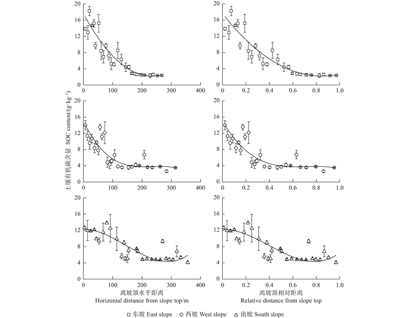
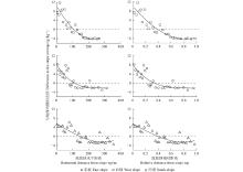
Fig.3
Variation of the difference of surface SOC content of plots to the slope average along the horizontal distance from slope top and relative distance from slope top"
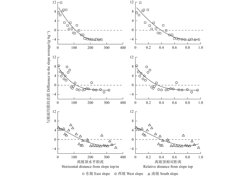
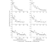
Fig.4
Variation of the ratio of surface SOC content of plots to the slope average along the horizontal distance from slope top and relative distance from slope top"

Table 2
Fitting relationship between the ratio of surface SOC content of plots to the slope average (y) and the distance from slope top (x)"
| 坡向 Slope aspect | 离坡顶水平距离 Horizontal distance from slope top | R2 | P | 离坡顶相对距离 Relative distance from slope top | R2 | P | |
| 东坡 East slope | 0.86 | <0.001 | 0.86 | <0.001 | |||
| 西坡 West slope | 0.71 | <0.001 | 0.71 | <0.001 | |||
| 南坡 South slope | 0.71 | <0.001 | 0.71 | <0.001 |
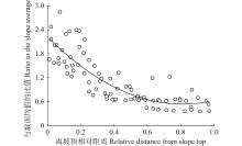
Fig.5
Variation of the ratio of surface SOC content of all plots to the three slope averages along the relative distance from slope top"
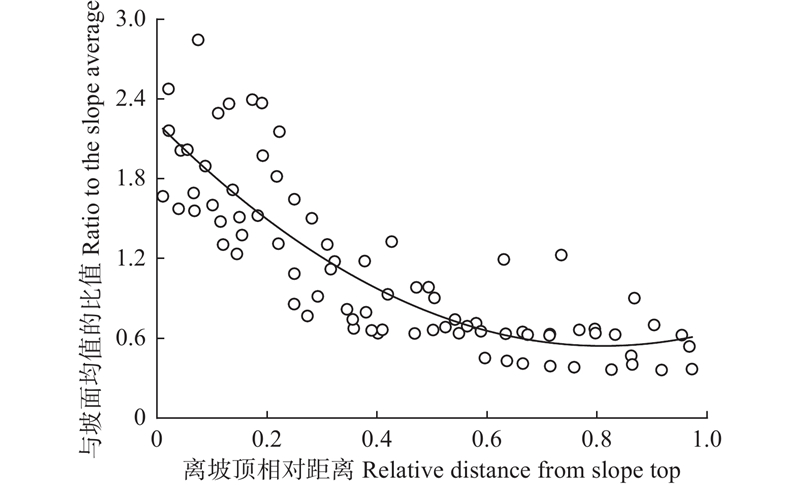
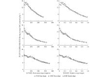
Fig.6
Variation of the moving average of surface SOC content along the horizontal distance from slope top and relative distance from slope top"

Table 3
Fitting relationship between the moving average (y) of surface SOC content and the distance (x) from slope top"
| 坡向 Slope aspect | 离坡顶水平距离 Horizontal distance from slope top | R2 | P | 离坡顶相对距离 Relative distance from slope top | R2 | P | |
| 东坡 East slope | 0.96 | <0.001 | 0.96 | <0.001 | |||
| 西坡 West slope | 0.97 | <0.001 | 0.97 | <0.001 | |||
| 南坡 South slope | 0.97 | <0.001 | 0.97 | <0.001 |
Fig.7
Differences of surface SOC content between two land use types on three slopes"


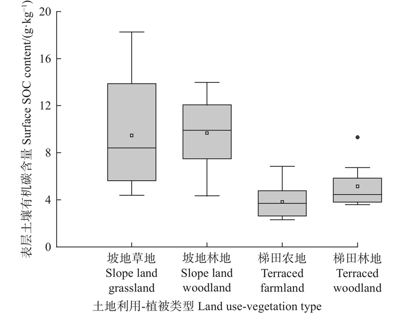
Fig.8
Differences of surface SOC content between different land use-vegetation types"
| 崔 东, 李卫红, 朱成刚, 等. 伊犁河谷不同土地利用方式下土壤有机碳含量与土壤理化性质相关性分析. 资源科学, 2016, 38 (7): 1239- 1245. | |
| Cui D, Li W H, Zhu C G, et al. Soil organic carbon content in relation to soil physicochemical properties under different land use types in the Yili valley. Resources Science, 2016, 38 (7): 1239- 1245. | |
| 郭胜利, 马玉红, 车升国, 等. 黄土区人工与天然植被对凋落物量和土壤有机碳变化的影响. 林业科学, 2009, 45 (10): 14- 18. | |
| Guo S L, Ma Y H, Che S G, et al. Effects of artificial and natural vegetations on litter production and soil organic carbon change in loess hilly areas. Scientia Silvae Sinicae, 2009, 45 (10): 14- 18. | |
| 韩新辉, 佟小刚, 杨改河, 等. 黄土丘陵区不同退耕还林地土壤有机碳库差异分析. 农业工程学报, 2012, 28 (12): 223- 229. | |
| Han X H, Tong X G, Yang G H, et al. Difference analysis of soil organic carbon pool in returning farmland to forest in loess hilly area. Transactions of the Chinese Society of Agricultural Engineering, 2012, 28 (12): 223- 229. | |
| 姜 娜, 邵明安. 黄土高原小流域不同坡地利用方式的水土流失特征. 农业工程学报, 2011, 27 (6): 36- 41. | |
| Jiang N, Shao M A. Characteristics of soil and water loss of different slope land uses in small watershed on the Loess Plateau. Transactions of the Chinese Society of Agricultural Engineering, 2011, 27 (6): 36- 41. | |
| 李 龙, 姚云峰, 秦富仓. 内蒙古赤峰梯田土壤有机碳含量分布特征及其影响因素. 生态学杂志, 2014, 33 (11): 2930- 2935. | |
| Li L, Yao Y F, Qin F C. Distribution and affecting factors of soil organic carbon of terraced fields in Chifeng, Inner Mongolia. Chinese Journal of Ecology, 2014, 33 (11): 2930- 2935. | |
| 刘泽彬, 王彦辉, 徐丽宏, 等. 六盘山华北落叶松林坡面土壤含水量的时空变化. 山地学报, 2018, 36 (1): 43- 52. | |
| Liu Z B, Wang Y H, Xu L H, et al. Spatial-temporal variations and scale effect of soil moisture on Larix principis-ruprechtii plantation slope in semihumid Liupan mountains, China. Mountain Research, 2018, 36 (1): 43- 52. | |
| 马南方, 高晓东, 赵西宁, 等. 黄土丘陵区退耕小流域土壤有机碳分布特征及地形植被对其的影响. 生态学报, 2022, 42 (14): 5838- 5846. | |
| Ma N F, Gao X D, Zhao X N, et al. Distribution characteristics of soil organic carbon and the effect of topographic and vegetation on small watershed of returned farmland in the loess hilly region. Acta Ecologica Sinica, 2022, 42 (14): 5838- 5846. | |
| 南雅芳, 郭胜利, 张彦军, 等. 坡向和坡位对小流域梯田土壤有机碳、氮变化的影响. 植物营养与肥料学报, 2012, 18 (3): 595- 601. | |
| Nan Y F, Guo S L, Zhang Y J, et al. Effects of slope aspect and position on soil organic carbon and nitrogen of terraces in small watershed. Plant Nutrition and Fertilizer Science, 2012, 18 (3): 595- 601. | |
| 王深华, 江 军, 刘丰彩, 等. 中国成熟天然林土壤有机碳垂直分异特征. 应用生态学报, 2021, 32 (7): 2371- 2377. | |
| Wang S H, Jiang J, Liu F C, et al. Vertical differentiation of soil organic carbon in mature natural forests in China. Chinese Journal of Applied Ecology, 2021, 32 (7): 2371- 2377. | |
| 王一佩, 孙美美, 程然然, 等. 黄土高原中西部人工针叶林浅层土壤有机碳积累及影响因素. 水土保持研究, 2020, 27 (3): 30- 36. | |
| Wang Y P, Sun M M, Cheng R R, et al. Accumulation of soil organic carbon and its influencing factors in coniferous plantations in the Midwestern Loess Plateau. Research of Soil and Water Conservation, 2020, 27 (3): 30- 36. | |
| 卫 玮, 党坤良. 秦岭南坡林地土壤有机碳密度空间分异特征. 林业科学, 2019, 55 (5): 11- 19. | |
| Wei W, Dang K L. Spatial variation of the density of soil organic carbon in forest land on the southern slope of Qinling mountains. Scientia Silvae Sinicae, 2019, 55 (5): 11- 19. | |
|
徐占军, 张 媛, 张绍良, 等. 基于GIS与分区Kriging的采煤沉陷区土壤有机碳含量空间预测. 农业工程学报, 2018, 34 (10): 253- 259.
doi: 10.11975/j.issn.1002-6819.2018.10.032 |
|
|
Xu Z J, Zhang Y, Zhang S L, et al. Spatial prediction of soil organic carbon content in coal mining subsidence area based on GIS and partition Kriging. Transactions of the Chinese Society of Agricultural Engineering, 2018, 34 (10): 253- 259.
doi: 10.11975/j.issn.1002-6819.2018.10.032 |
|
| 杨思存, 王成宝, 霍 琳, 等. 不同耕作措施对甘肃引黄灌区耕地土壤有机碳的影响. 农业工程学报, 2019, 35 (2): 114- 121. | |
| Yang S C, Wang C B, Huo L, et al. Effects of different tillage practices on soil organic carbon of cultivated land in Gansu Yellow River irrigation district. Transactions of the Chinese Society of Agricultural Engineering, 2019, 35 (2): 114- 121. | |
| 余 杭, 孙 凡, 李松阳, 等. 不同区段金沙江下游山地失稳性坡面土壤有机碳含量特征. 应用与环境生物学报, 2020, 26 (5): 1192- 1199. | |
| Yu H, Sun F, Li S Y, et al. Characteristics of soil organic carbon content in different sections of the unstable slopes of the mountainous area in the lower reaches of the Jinsha River. Chinese Journal of Applied and Environmental Biology, 2020, 26 (5): 1192- 1199. | |
| 余 健, 房 莉, 卞正富, 等. 土壤碳库构成研究进展. 生态学报, 2014, 34 (17): 4829- 4838. | |
| Yu J, Fang L, Bian Z F, et al. A review of the composition of soil carbon pool. Acta Ecologica Sinica, 2014, 34 (17): 4829- 4838. | |
| 张美丽, 姚云峰, 李 龙, 等. 梯田不同作物土壤有机碳含量及其影响因素分析. 中国土壤与肥料, 2017, (1): 14- 20. | |
| Zhang M L, Yao Y F, Li L, et al. Analysis of soil organic carbon content of fields growing different crops and its affecting factors in the terraced fields. Soil and Fertilizer Sciences in China, 2017, (1): 14- 20. | |
|
张全军, 于秀波, 钱建鑫, 等. 鄱阳湖南矶湿地优势植物群落及土壤有机质和营养元素分布特征. 生态学报, 2012, 32 (12): 3656- 3669.
doi: 10.5846/stxb201111201768 |
|
|
Zhang Q J, Yu X B, Qian J X, et al. Distribution characteristics of plant communities and soil organic matter and main nutrients in the Poyang Lake Nanji Wetland. Acta Ecologica Sinica, 2012, 32 (12): 3656- 3669.
doi: 10.5846/stxb201111201768 |
|
| 张 桐, 王彦辉, 王玉杰, 等. 黄土高原土石山区土壤密度的坡面变化: 以六盘山香水河小流域为例. 林业科学研究, 2016, 29 (4): 545- 552. | |
| Zhang T, Wang Y H, Wang Y J, et al. Variation of soil bulk density on slopes in the rocky mountains areas of Loess Plateau, Northwest China: a case study of Xiangshuihe small watershed in Liupan mountains. Forest Research, 2016, 29 (4): 545- 552. | |
| 张 祎, 李 鹏, 肖 列, 等. 黄土高原丘陵区地形和土地利用对土壤有机碳的影响. 土壤学报, 2019, 56 (5): 1140- 1150. | |
| Zhang Y, Li P, Xiao L, et al. Effects of topography and land use on soil organic carbon in hilly region of Loess Plateau. Acta Pedologica Sinica, 2019, 56 (5): 1140- 1150. | |
| 周 鑫, 姜 航, 孙金兵, 等. 地形因子和物理保护对张广才岭次生林土壤有机碳密度的影响. 北京林业大学学报, 2016, 38 (4): 94- 106. | |
| Zhou X, Jiang H, Sun J B, et al. Soil organic carbon density as affected by topography and physical protection factors in the secondary forest area of Zhangguangcai mountains, northeast China. Journal of Beijing Forestry University, 2016, 38 (4): 94- 106. | |
| 周晓宇, 张称意, 郭广芬. 气候变化对森林土壤有机碳贮藏影响的研究进展. 应用生态学报, 2010, 21 (7): 1867- 1874. | |
| Zhou X Y, Zhanga C Y, Guo G F, et al. Effects of climate change on forest soil organic carbon storage: a review. Chinese Journal of Applied Ecology, 2010, 21 (7): 1867- 1874. | |
| 祝元丽, 王冬艳, 张 鹤, 等. 采用无人机载高分辨率光谱仪反演土壤有机碳含量. 农业工程学报, 2021, 37 (6): 66- 72. | |
| Zhu Y L, Wang D Y, Zhang H, et al. Soil organic carbon content retrieved by UAV-borne high resolution spectrometer. Transactions of the Chinese Society of Agricultural Engineering, 2021, 37 (6): 66- 72. | |
|
Chen L F, He Z B, Zhu X, et al. Impacts of afforestation on plant diversity, soil properties, and soil organic carbon storage in a semi-arid grassland of northwestern China. Catena, 2016, 147, 300- 307.
doi: 10.1016/j.catena.2016.07.009 |
|
|
Chen Y Y, Yang K, Tang W J, et al. Parameterizing soil organic carbon’s impacts on soil porosity and thermal parameters for eastern Tibet grasslands. Science China Earth Sciences, 2012, 55 (6): 1001- 1011.
doi: 10.1007/s11430-012-4433-0 |
|
| Davidson E A, Janssens I A. Temperature sensitivity of soil carbon decomposition and feedbacks to climate change. Nature, 2006, 440 (S1): 165- 173. | |
|
Deng L, Liu S G, Kim D G, et al. Past and future carbon sequestration benefits of china's grain for green program. Global Environmental Change, 2017, 47, 13- 20.
doi: 10.1016/j.gloenvcha.2017.09.006 |
|
|
Diffenbaugh N S, Field C B. Changes in ecologically critical terrestrial climate conditions. Science, 2013, 341 (6145): 486- 492.
doi: 10.1126/science.1237123 |
|
|
Fang J Y, Guo Z D, Piao S L, et al. Terrestrial vegetation carbon sinks in China, 1981–2000. Science in China Series D, 2007, 50 (9): 1341- 1350.
doi: 10.1007/s11430-007-0049-1 |
|
|
Friggens N L, Hester A J, Mitchell R J, et al. Tree planting in organic soils does not result in net carbon sequestration on decadal timescales. Global Change Biology, 2020, 26 (9): 5178- 5188.
doi: 10.1111/gcb.15229 |
|
|
Kirschbaum M U F, Guo L B, Gifford R M. Observed and modelled soil carbon and nitrogen changes after planting a Pinus radiata stand onto former pasture. Soil Biology and Biochemistry, 2008, 40 (1): 247- 257.
doi: 10.1016/j.soilbio.2007.08.021 |
|
|
Kyaschenko J, Clemmensen K E, Karltun E, et al. Below-ground organic matter accumulation along a boreal forest fertility gradient relates to guild interaction within fungal communities. Ecology Letters, 2017, 20 (12): 1546- 1555.
doi: 10.1111/ele.12862 |
|
|
Li Y, Zhang Q W, Reicosky D C, et al. Using 137Cs and 210Pbex for quantifying soil organic carbon redistribution affected by intensive tillage on steep slopes. Soil and Tillage Research, 2006, 86 (2): 176- 184.
doi: 10.1016/j.still.2005.02.006 |
|
|
Post W M, Kwon K C. Soil carbon sequestration and land-use change: processes and potential. Global Change Biology, 2000, 6 (3): 317- 327.
doi: 10.1046/j.1365-2486.2000.00308.x |
|
|
Rey A, Petsikos C, Jarvis P G, et al. Effect of temperature and moisture on rates of carbon mineralization in a Mediterranean oak forest soil under controlled and field condition. European Journal of Soil Science, 2005, 56 (5): 589- 599.
doi: 10.1111/j.1365-2389.2004.00699.x |
|
|
Schipper L A, Baisden W T, Parfitt R L, et al. Large losses of soil C and N from soil profiles under pasture in New Zealand during the past 20 years. Global Change Biology, 2007, 13 (6): 1138- 1144.
doi: 10.1111/j.1365-2486.2007.01366.x |
|
| Vesterdal L, Ritter E, Gundersen P. Change in soil organic carbon following afforestation of former arable land. Forest Ecology and Management, 2002, 169 (1/2): 137- 147. | |
| Wang H H, Yue C, Mao Q Q, et al. Vegetation and species impacts on soil organic carbon sequestration following ecological restoration over the Loess Plateau, China. Geoderma, 2020, 371 (1): 114389- 114400. | |
|
Yang J J, Qin R Z, Shi X P, et al. The effects of plastic film mulching and straw mulching on licorice root yield and soil organic carbon content in a dryland farming. Science of the Total Environment, 2022, 826, 154113.
doi: 10.1016/j.scitotenv.2022.154113 |
|
|
Zhang Z Y, Guo J B, Wang Y H, et al. Variation of soil organic carbon density with plantation age and initial vegetation types in the Liupan mountains areas of northwest China. Forests, 2021, 12 (12): 1811.
doi: 10.3390/f12121811 |
|
|
Zhu X C, Shao M A. Distribution, stock, and influencing factors of soil organic carbon in an alpine meadow in the hinterland of the Qinghai-Tibetan Plateau. Journal of Earth System Science, 2018, 127 (5): 71.
doi: 10.1007/s12040-018-0974-8 |
|
|
Zimmerman A R, Gao B, Ahn M Y. Positive and negative carbon mineralization priming effects among a variety of biochar-amended soils. Soil Biology and Biochemistry, 2011, 43 (6): 1169- 1179.
doi: 10.1016/j.soilbio.2011.02.005 |
| Viewed | ||||||
|
Full text |
|
|||||
|
Abstract |
|
|||||