
Scientia Silvae Sinicae ›› 2025, Vol. 61 ›› Issue (9): 1-11.doi: 10.11707/j.1001-7488.LYKX20250100
• Research papers •
Jiaheng Hao1,Yichao Guo1,Hao Li1,Aiqing Zhu3,Lei Shi1,2,*( )
)
Received:2025-02-24
Online:2025-09-25
Published:2025-10-10
Contact:
Lei Shi
E-mail:leishi@icbr.ac.cn
CLC Number:
Jiaheng Hao,Yichao Guo,Hao Li,Aiqing Zhu,Lei Shi. Vegetation Cover Extraction of Bamboo Forest in China Based on Time-Series Remote Sensing Indices[J]. Scientia Silvae Sinicae, 2025, 61(9): 1-11.

Fig.1
Schematic diagram of sample points located in China’s bamboo forest distribution area"
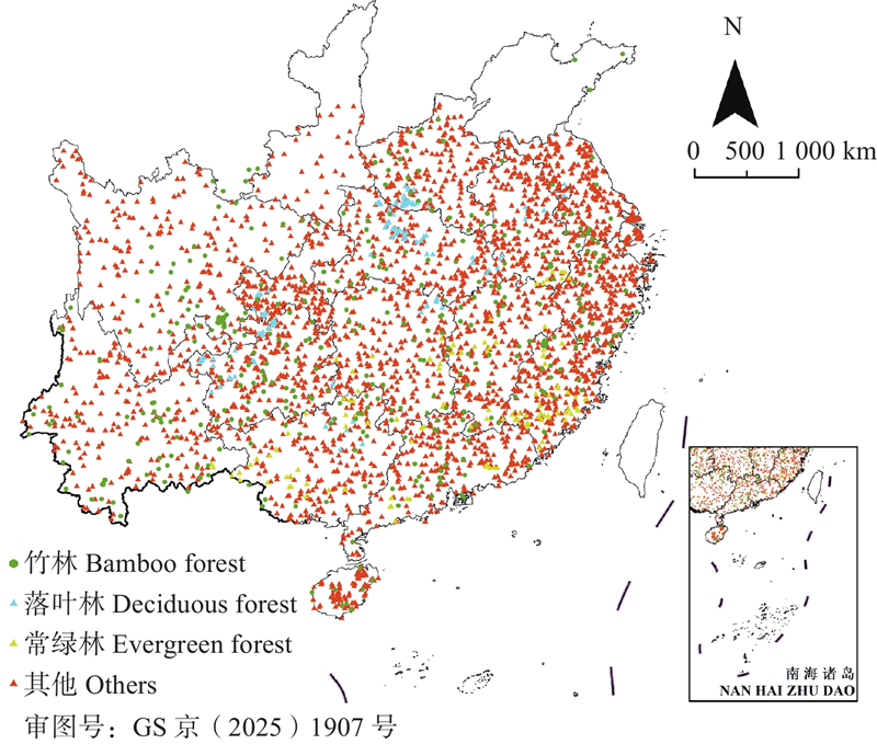
Fig.2
Monthly variation of spectral reflectance of red light and short-wave infrared"
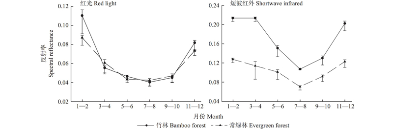
Table 1
Candidate features and their calculation formulas for the traditional index and the red edge spectral index"
| 特征类别 Feature category | 特征名称 Feature name | 计算公式 Calculation formula |
| 传统指数 Traditional index | 归一化植被指数 Normalized difference vegetation index (NDVI) | |
| 归一化水体指数 Normalized difference water index (NDWI) | ||
| 增强植被指数 Enhanced vegetation index (EVI) | ||
| 红边指数 Red-edge index | 红边比值植被指数 Red-edge ratio vegetation index (RVI) | |
| 红边综合效应指数 Red-edge integrated vegetation index (MVI) | ||
| 红边竹林指数1 Red-edge bamboo forest index (BI1) | ||
| 红边竹林指数2 Red-edge bamboo forest index (BI2) |
Table 2
Feature sets for classification schemes and their variable components"
| 编号 No. | 特征组合 Feature set | 特征变量个数 Number of feature variables |
| FS1 | 原始波段+传统指数 Original bands + traditional indices | 6+3 |
| FS2 | 原始波段+传统指数+红边指数 Original bands + traditional indices + red-edge indices | 6+3+4 |
| FS3 | 原始波段+传统指数+时序遥感指数 Original bands + traditional indices + time-series indices | 6+3+5 |
| FS4 | 原始波段+传统指数+红边指数+时序遥感指数 Original bands + traditional indices + red-edge indices + time-series indices | 6+3+4+5 |
Table 3
Confusion matrix accuracy assessment results for the different feature sets"
| 分类组合 Feature set | 总体精度 Overall accuracy | Kappa系数 Kappa coefficient | 竹林 Bamboo forest | 常绿林 Evergreen forest | 落叶林 Deciduous forest | 非林地 Non forest land | |||||||
| PA | UA | PA | UA | PA | UA | PA | UA | ||||||
| FS1 | 0.75 | 0.73 | 0.72 | 0.61 | 0.60 | 0.68 | 0.68 | 0.77 | 0.87 | 0.86 | |||
| FS2 | 0.81 | 0.77 | 0.79 | 0.75 | 0.74 | 0.80 | 0.82 | 0.77 | 0.89 | 0.92 | |||
| FS 3 | 0.87 | 0.80 | 0.89 | 0.83 | 0.79 | 0.83 | 0.85 | 0.88 | 0.91 | 0.93 | |||
| FS4 | 0.92 | 0.88 | 0.95 | 0.85 | 0.84 | 0.92 | 0.92 | 0.88 | 0.91 | 0.97 | |||
Fig.3
China’s bamboo forest distribution interpreted based on Sentinel-2 imagery"
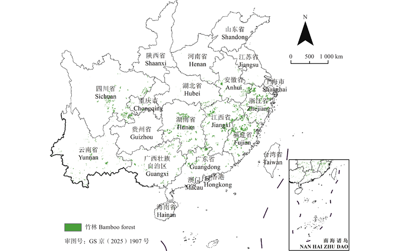
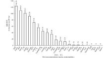
Fig.4
Interpreted bamboo forest area at the provincial ( autonomous regional,or municipal) scale"

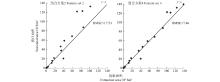
Fig.5
Comparison map of bamboo forest area based on remote sensing interpretation and forest resource statistics"
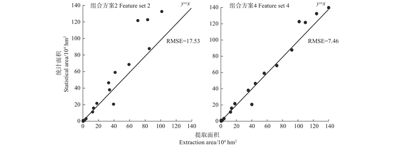
Fig.6
Comparison of the interpretation results with high-resolution images from Google Earth: a case of Tonggu township, Changning county, Sichuan province The area in red line in Figure (a) is bamboo forest, the area in green line denoted “I” is forest land, and the area “II” in green line is bare land and cultivated land, respectively."
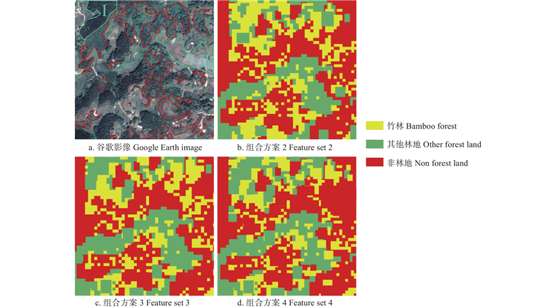
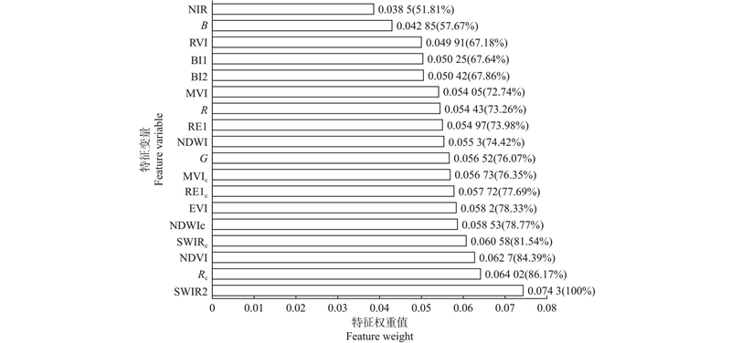
Fig.7
Feature weights and their importance ranking R, G, B, NIR, RE1, and SWIR2 represent red, green, blue, near-infrared, red edge, and short-wave infrared features, respectively;NDVI, NDWI, and EVI represent the normalized vegetation index, normalized water index, and enhanced vegetation index characteristics, respectively;MVI, RVI, BI1, and BI2 represent the red edge composite effect index, red edge ratio vegetation index, red edge bamboo forest index 1, and red edge bamboo forest index 2, respectively; Rc, RE1c, SWIRc, NDWIc, and MVIc represent the red light winter-summer change rate index, the red edge 1 winter-summer change rate index, the short-wave infrared winter-summer change rate index, the normalized water body winter-summer change index, and the red edge comprehensive effect winter-summer change rate index, respectively. To highlight the importance of each feature variable, compare the weight of each feature with the highest weighted shortwave infrared (SWIR2) feature to obtain the relative importance of each feature variable. The values in parentheses represent the relative importance of SWIR2 features."
| 龚健雅. 人工智能时代测绘遥感技术的发展机遇与挑战. 武汉大学学报(信息科学版), 2018, 43 (12): 1788- 1796. | |
| Gong J Y. Development opportunities and challenges of surveying and remote sensing technology in the age of artificial intelligence. Geomatics and Information Science of Wuhan University, 2018, 43 (12): 1788- 1796. | |
| 顾大形, 陈双林, 郑炜曼, 等. 竹子生态适应性研究综述. 竹子研究汇刊, 2010, 29 (1): 17- 23. | |
| Gu D X, Chen S L, Zheng W M, et al. Review of the ecologicol adaptability of bamboo. Journal of Bamboo Research, 2010, 29 (1): 17- 23. | |
| 官凤英, 邓旺华, 范少辉. 毛竹林光谱特征及其与典型植被光谱差异分析. 北京林业大学学报, 2012, 34 (3): 31- 35. | |
| Guan F Y, Deng W H, Fan S H. Spectral characteristics of Phyllostachys pubescens forests and spectral differences from typical vegetation. Journal of Beijing Forestry University, 2012, 34 (3): 31- 35. | |
| 国家林业和草原局. 2019. 中国森林资源报告(2014—2018). 北京: 中国林业出版社. | |
| National Forestry and Grassland Administration. 2019. China forest resources report (2014−2018). Beijing: China Forestry Publishing House. [in Chinese] | |
| 国家林业和草原局. 2023. 2021中国林草生态综合监测评价报告. 北京: 中国林业出版社. | |
| National Forestry and Grassland Administration. 2023. 2021 China forest and grassland ecological comprehensive monitoring and evaluation report. Beijing: China Forestry Publishing House. [in Chinese] | |
| 林兴稳, 闻建光, 吴胜标, 等. 地表反射率地形校正物理模型与效果评价方法研究进展. 遥感学报, 2020, 24 (8): 958- 974. | |
| Lin X W, Wen J G, Wu S B, et al. Advances in physical models and evaluation methods for topographic correction of surface reflectance. Journal of Remote Sensing, 2020, 24 (8): 958- 974. | |
|
罗涟玲, 王修信, 农京辉, 等. 遥感图像林型纹理特征的ICA与SVM分类. 计算机工程与应用, 2012, 48 (13): 227- 229,239.
doi: 10.3778/j.issn.1002-8331.2012.13.048 |
|
|
Luo L L, Wang X X, Nong J H, et al. ICA and SVM classification of forest type texture features in remote sensing images. Computer Engineering and Applications, 2012, 48 (13): 227- 229,239.
doi: 10.3778/j.issn.1002-8331.2012.13.048 |
|
|
单博文, 李 祎, 石 雷, 等. 1960—2050年中国竹林区极端气候的时空变化. 林业科学, 2025, 61 (2): 50- 61.
doi: 10.11707/j.1001-7488.LYKX20220728 |
|
|
Shan B W, Li Y, Shi L, et al. Spatiotemporal change of the extreme climate in China’s bamboo forest during 1960—2050. Scientia Silvae Sinicae, 2025, 61 (2): 50- 61.
doi: 10.11707/j.1001-7488.LYKX20220728 |
|
| 孙晓艳, 杜华强, 韩 凝, 等. 面向对象多尺度分割的SPOT5影像毛竹林专题信息提取. 林业科学, 2013, 49 (10): 80- 87. | |
| Sun X Y, Du H Q, Han N, et al. Object-oriented multi-scale segmentation for Phyllostachys pubescens information extraction from SPOT5 imagery. Scientia Silvae Sinicae, 2013, 49 (10): 80- 87. | |
| 田 宇. 2022. 基于生态环境效应约束的大庆市景观格局优化研究. 哈尔滨: 东北林业大学. | |
| Tian Y. 2022. Research on landscape pattern optimization of Daqing City based on ecological environment effect constraints. Harbin: Northeast Forestry University. [in Chinese] | |
|
王李娟, 孔钰如, 杨小冬, 等. 基于特征优选随机森林算法的农耕区土地利用分类. 农业工程学报, 2020, 36 (4): 244- 250.
doi: 10.11975/j.issn.1002-6819.2020.04.029 |
|
|
Wang L J, Kong Y R, Yang X D, et al. Land use classification in agricultural areas based on feature selection and random forest algorithm. Transactions of the Chinese Society of Agricultural Engineering, 2020, 36 (4): 244- 250.
doi: 10.11975/j.issn.1002-6819.2020.04.029 |
|
| 严欣荣, 张美曼, 郑亚雄, 等. 基于Sentinel-2的丛生竹林信息提取方法比较及分布特征. 生态学杂志, 2020, 39 (3): 1056- 1066. | |
| Yan X R, Zhang M M, Zheng Y X, et al. Comparison of extraction methods and distribution characteristics of clumping bamboo forests based on Sentinel-2. Chinese Journal of Ecology, 2020, 39 (3): 1056- 1066. | |
| 杨 丽, 李 祎, 单博文, 等. 竹林土壤碳储量的空间变异分析: 以四川长宁县为例. 生态学杂志, 2023, 42 (4): 854- 861. | |
| Yang L, Li Y, Shan B W, et al. Spatial variation of soil organic carbon of bamboo forest: a case study in Changning County, Sichuan Province. Chinese Journal of Ecology, 2023, 42 (4): 854- 861. | |
| 姚茂林, 江 洪, 张丽玉. 基于Sentinel-2影像红边光谱指数与特征优选的竹林提取研究. 海南大学学报(自然科学版), 2022, 40 (4): 373- 381. | |
| Yao M L, Jiang H, Zhang L Y. Bamboo forest extraction based on red-edge spectral indices and feature selection from Sentinel-2 imagery. Journal of Hainan University (Natural Science Edition), 2022, 40 (4): 373- 381. | |
| 郑容姝. 2003. 沿海沙地引种绿竹等竹子的抗盐抗旱机理研究. 福州: 福建农林大学. | |
| Zheng R S. 2003. Study on the salt and drought resistance mechanism of introducing bamboo such as green bamboo into coastal sandy land. Fuzhou: Fujian Agriculture And Forestry University. [in Chinese] | |
| 周芳纯. 1998. 竹林培育学. 北京: 中国林业出版社. | |
| Zhou F C. 1998. Bamboo forest cultivation. Beijing: China Forestry Publishing House. [in Chinese] | |
| Abbas A M, Amanabo U H. Harnessing the economic and environmental benefits of bamboo in Nigeria. Alanya Academic Review, 2017, 1 (3): 39- 47. | |
|
Leo B. Random forests. Machine Learning, 2001, 45 (1): 5- 32.
doi: 10.1023/A:1010933404324 |
|
|
Li J F, Wang L Y, Liu S Q, et al. An automatic cloud detection model for Sentinel-2 imagery based on Google Earth Engine. Remote Sensing Letters, 2022, 13 (2): 196- 206.
doi: 10.1080/2150704X.2021.1988753 |
|
|
Li L, Li N, Lu D, et al. Mapping moso bamboo forest and its on-year and off-year distribution in a subtropical region using time-series Sentinel-2 and Landsat 8 data. Remote Sensing of Environment, 2019, 231, 111265.
doi: 10.1016/j.rse.2019.111265 |
|
| Li M N, Li C C, Jiang H, et al. 2016. Tracking bamboo dynamics in Zhejiang, China, using time-series of Landsat data from 1990 to 2014. International Journal of Remote Sensing 37(7): 1714−1729. | |
|
Linderman M, Liu J, Qi J, et al. Using artificial neural networks to map the spatial distribution of understorey bamboo from remote sensing data. International Journal of Remote Sensing, 2004, 25 (9): 1685- 1700.
doi: 10.1080/01431160310001598971 |
|
|
Liu G, Li L, Gong H, et al. Multisource remote sensing imagery fusion scheme based on bidimensional empirical mode decomposition (BEMD) and its application to the extraction of bamboo forest. Remote Sensing, 2016, 9 (1): 19.
doi: 10.3390/rs9010019 |
|
|
McFeeters S K. The use of the normalized difference water index (NDWI) in the delineation of open water features. International Journal of Remote Sensing, 1996, 17 (7): 1425- 1432.
doi: 10.1080/01431169608948714 |
|
|
Nagler L P, Scott L R, Westenburg C, et al. Evapotranspiration on western U. S. rivers estimated using the enhanced vegetation index from MODIS and data from eddy covariance and Bowen ratio flux towers. Remote Sensing of Environment, 2005, 97 (3): 337- 351.
doi: 10.1016/j.rse.2005.05.011 |
|
|
Qi S, Bin Song, Liu C, et al. Bamboo forest mapping in China using the dense Landsat 8 image archive and Google Earth Engine. Remote Sensing, 2022, 14 (3): 762.
doi: 10.3390/rs14030762 |
|
|
Shoko C, Mutanga O. Examining the strength of the newly-launched Sentinel 2 MSI sensor in detecting and discriminating subtle differences between C3 and C4 grass species. ISPRS Journal of Photogrammetry and Remote Sensing, 2017, 129, 32- 40.
doi: 10.1016/j.isprsjprs.2017.04.016 |
|
| Takeuchi W, Yasuoka Y. Development of normalized vegetation, soil and water indices derived from satellite remote sensing data. Journal of the Japan Society of Photogrammetry and Remote Sensing, 2005, 43 (6): 7- 19. | |
|
You S, Zheng Q, Lin Y, et al. Specific bamboo forest extraction and long-term dynamics as revealed by landsat time series stacks and Google Earth Engine. Remote Sensing, 2020, 12 (18): 3095.
doi: 10.3390/rs12183095 |
| [1] | Chunling Wang,Kaiyuan Shi,Yong Pang,Shili Meng. Forest Cover Mapping of Central and Eastern European Countries Based on Change Detection and Update [J]. Scientia Silvae Sinicae, 2024, 60(5): 116-126. |
| [2] | Yaxiong Zheng,Shaohui Fan,Xuan Zhang,Xiao Zhou,Fengying Guan. Productivity Dynamics of Moso Bamboo (Phyllostachys edulis) Forest after Strip Clearcutting [J]. Scientia Silvae Sinicae, 2023, 59(2): 22-29. |
| [3] | Caixia Liu,Junhui Chen,Hua Qin,Chenfei Liang,Qiufang Xu. Effects of Long-Term Combined Application of Organic and Inorganic Fertilizers on Soil CO2- and N2-Fixing Microorganisms in a Subtropical Bamboo Forest [J]. Scientia Silvae Sinicae, 2022, 58(7): 82-92. |
| [4] | Yulu Xiong,Yufeng Zhou,Pingheng Li,Liang Tong,Guomo Zhou,Yongjun Shi,Huaqiang Du. Non-Destructive Detection by Ground Penetrating Radar of Growth Characteristics and Spatial Structure of Rhizomes in Moso Bamboo Forest [J]. Scientia Silvae Sinicae, 2020, 56(12): 19-27. |
| [5] | Li Yangguang, Du Huaqiang, Mao Fangjie, Li Xuejian, Cui Lu, Han Ning, Xu Xiaojun. Information Extracting and Spatiotemporal Evolution of Bamboo Forest Based on Landsat Time Series Data in Zhejiang Province [J]. Scientia Silvae Sinicae, 2019, 55(3): 88-96. |
| [6] | Chen Liang, Zhou Guomo, Du Huaqiang, Liu Yuli, Mao Fangjie, Xu Xiaojun, Li Xuejian, Cui Lu, Li Yangguang, Zhu Di. Simulation of CO2 Flux and Controlling Factors in Moso Bamboo Forest Using Random Forest Algorithm [J]. Scientia Silvae Sinicae, 2018, 54(8): 1-12. |
| [7] | Li Chong, Zhou Guomo, Shi Yongjun, Zhou Yufeng, Xu Lin, Fan Yeqing, Shen Zhenming, Li Shaohong, Lü Yulong. Effects of Different Management Measures on the Net Carbon Sequestration Capacity of Moso bamboo Forest Ecosystem [J]. Scientia Silvae Sinicae, 2017, 53(2): 1-9. |
| [8] | Gao Guolong, Du Huaqiang, Han Ning, Xu Xiaojun, Sun Shaobo, Li Xuejian. Mapping of Moso Bamboo Forest Using Object-Based Approach Based on the Optimal Features [J]. Scientia Silvae Sinicae, 2016, 52(9): 77-85. |
| [9] | Xu Xiaojun, Zhou Guomo, Du Huaqiang, Zhou Yufeng, Hu Junguo, Lu Guofu. Effects of Sample Plots Stratification on Estimation Accuracy of Aboveground Carbon Storage for Phyllostachys edulis Forests [J]. Scientia Silvae Sinicae, 2013, 49(6): 18-24. |
| [10] | Sun Xiaoyan, Du Huaqiang, Han Ning, Ge Hongli, Gu Chengyan. Multi-Scale Segmentation, Object-Based Extraction of Moso Bamboo Forest from SPOT 5 Imagery [J]. Scientia Silvae Sinicae, 2013, 49(10): 80-87. |
| [11] | Guo Xiaomin;Niu Dekui;Fan Fangli;Chen Fang;Zhang Guoshi;Zhou Yuxin;Zhang Bin. Regression Analysis of Leaf Nutrition,Soil Fertility and Output in Bamboo Forest of Balance Fertilization [J]. , 2007, 43(zk): 53-57. |
| [12] | Li Weicheng;Sheng Haiyan;Zhong Zheke. Importance of Long-Term Location Investigation for Bamboo Ecosystem [J]. Scientia Silvae Sinicae, 2006, 42(8): 95-101. |
| [13] | Yushan Zheng,Wei Hong,Liguang Chen,Tianhua Zhang. STUDY ON STRUCTURE CHARACTERISTICS OF RHIZOMES IN HIGH-YIELD PHYLLOSTACHYS HETEROCYCLA CV.PUBESCENS FORESTS [J]. Scientia Silvae Sinicae, 1998, 34(zk): 52-59. |
| Viewed | ||||||
|
Full text |
|
|||||
|
Abstract |
|
|||||