
Scientia Silvae Sinicae ›› 2024, Vol. 60 ›› Issue (12): 13-26.doi: 10.11707/j.1001-7488.LYKX20230469
Previous Articles Next Articles
Fan Zhang1,Tianhao Qiu1,Xinyue Li1,Shuyin Zhang1,*,Chao Xu1,Zhiguo Xie2
Received:2023-10-08
Online:2024-12-25
Published:2025-01-02
Contact:
Shuyin Zhang
CLC Number:
Fan Zhang,Tianhao Qiu,Xinyue Li,Shuyin Zhang,Chao Xu,Zhiguo Xie. Vegetation Fractional Cover Extraction and Spatiotemporal Variation Analysis Based on Improved Normalized Difference Vegetation Index (NDVI) and Dry Fuel Index (DFI) Model[J]. Scientia Silvae Sinicae, 2024, 60(12): 13-26.
Table 1
Landsat data product selection from 2000 to 2022"
| 影像名称 Image name | 年份 Year | 选取原因 Reason for Selection |
| Landsat 5/TM | 2000—2011 | 同期可选产品有Landsat 5和Landsat 7,但2003年起Landsat 7数据存在异常,故选择Landsat 5 Concurrently available products include Landsat 5 and Landsat 7, but Landsat 7 data has been abnormal since 2003, thus Landsat 5 was selected. |
| Landsat 7/ETM+ | 2012 | Landsat系列影像只有Landsat 7有2012年影像数据,使用landsat_gapfill工具进行条带错误修复 Only Landsat 7 in the Landsat series has image data from 2012. The landsat_gapfill tool was used to repair stripe errors. |
| Landsat 8/OLI | 2013—2022 | 2013年发射的新卫星,配备更先进的传感器,数据质量更好 A new satellite launched in 2013, equipped with more advanced sensors, providing better data quality. |
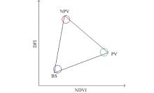
Fig.1
Ideal feature space of NDVI-DFI model"
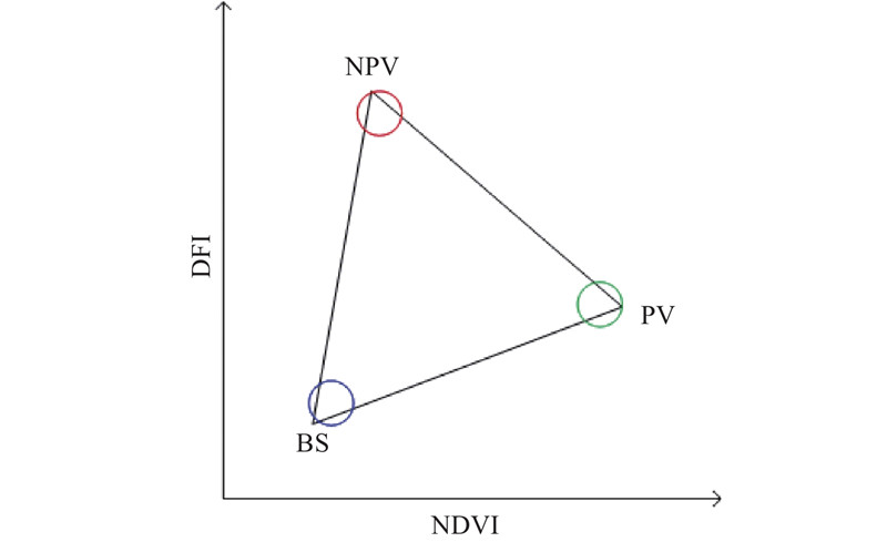

Fig.2
AEEE algorithm flowchart"
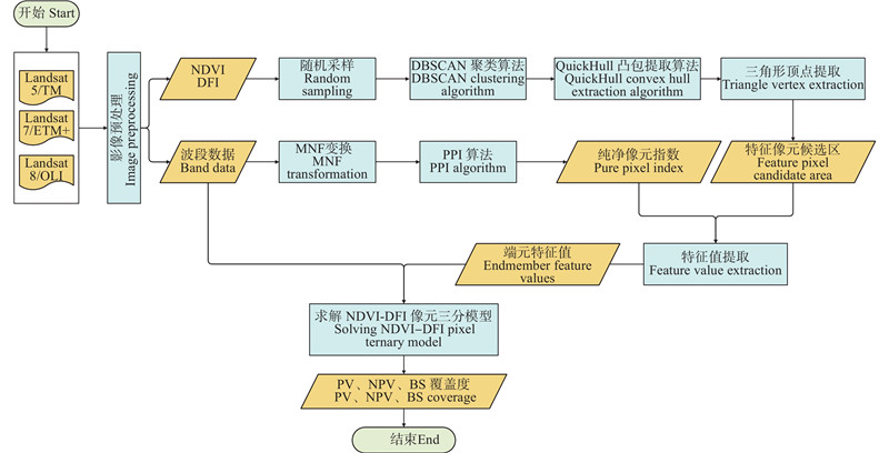
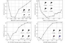
Fig.3
Parameter variation analysis Parameter analysis shows the variation of relative errors under different values of 4 parameters. The subplots in the lower right corner (with the average neighborhood subplot in the middle position) represent the feature space of the NDVI-DFI pixel ternary model for different parameter values. Green indicates PV feature pixel candidate area, red indicates NPV feature pixel candidate area, and blue indicates BS feature pixel candidate area."
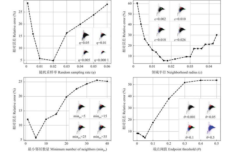
Table 2
Parameter combination calibration results"
| minpts | 相对误差 Relative error(%) | minpts | 相对误差 Relative error(%) | minpts | 相对误差 Relative error(%) | |||||||||||
| 0.01 | 0.014 | 4 | 0.04 | 10.96 | 0.01 | 0.018 | 4 | 0.04 | 9.37 | 0.02 | 0.016 | 4 | 0.04 | 17.34 | ||
| 0.01 | 0.014 | 4 | 0.05 | 11.50 | 0.01 | 0.018 | 4 | 0.05 | 9.39 | 0.02 | 0.016 | 4 | 0.05 | 13.67 | ||
| 0.01 | 0.014 | 5 | 0.04 | 10.07 | 0.01 | 0.018 | 5 | 0.04 | 8.55 | 0.02 | 0.016 | 5 | 0.04 | 14.21 | ||
| 0.01 | 0.014 | 5 | 0.05 | 11.58 | 0.01 | 0.018 | 5 | 0.05 | 8.16 | 0.02 | 0.016 | 5 | 0.05 | 11.15 | ||
| 0.01 | 0.014 | 6 | 0.04 | 10.61 | 0.01 | 0.018 | 6 | 0.04 | 7.65 | 0.02 | 0.016 | 6 | 0.04 | 11.74 | ||
| 0.01 | 0.014 | 6 | 0.05 | 12.40 | 0.01 | 0.018 | 6 | 0.05 | 7.98 | 0.02 | 0.016 | 6 | 0.05 | 9.78 | ||
| 0.01 | 0.016 | 4 | 0.04 | 9.37 | 0.02 | 0.014 | 4 | 0.04 | 11.95 | 0.02 | 0.018 | 4 | 0.04 | 24.68 | ||
| 0.01 | 0.016 | 4 | 0.05 | 8.63 | 0.02 | 0.014 | 4 | 0.05 | 10.34 | 0.02 | 0.018 | 4 | 0.05 | 20.07 | ||
| 0.01 | 0.016 | 5 | 0.04 | 7.72 | 0.02 | 0.014 | 5 | 0.04 | 9.40 | 0.02 | 0.018 | 5 | 0.04 | 19.96 | ||
| 0.01 | 0.016 | 5 | 0.05 | 7.35 | 0.02 | 0.014 | 5 | 0.05 | 8.75 | 0.02 | 0.018 | 5 | 0.05 | 15.94 | ||
| 0.01 | 0.016 | 6 | 0.04 | 8.98 | 0.02 | 0.014 | 6 | 0.04 | 9.37 | 0.02 | 0.018 | 6 | 0.04 | 15.57 | ||
| 0.01 | 0.016 | 6 | 0.05 | 10.18 | 0.02 | 0.014 | 6 | 0.05 | 9.34 | 0.02 | 0.018 | 6 | 0.05 | 12.72 |
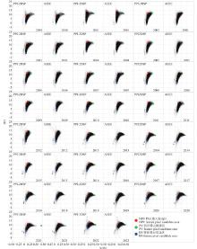
Fig.4
Feature space of NDVI-DFI pixel ternary model from 2000 to 2022 In the feature space of NDVI-DFI pixel ternary model for each year, the red color represents the feature pixel candidate region for NPV, the green color represents the feature pixel candidate region for PV, and the blue color represents the feature pixel candidate region for BS. On the left is the PPI-2DSP algorithm, which employs a circular template for manual delineation of the region. On the right, we have the results extracted using the AEEE algorithm, where the algorithm applies coloration to points within the candidate area."

Table 3
The relative error in extracting elemental features using the PPI-2DSP algorithm and the AEEE algorithm from 2000 to 2022"
| 特征值类型 Type of eigenvalue | PPI-2DSP 算法提取 Extraction using the PPI-2DSP | AEEE算法 提取 Extraction using the AEEE | 相对误差 Relative error (%) |
| BS端元的NDVI特征值 NDVI eigenvalue of the BS endmember | 0.070 | 0.073 | 9.56 |
| PV端元的NDVI特征值 NDVI eigenvalue of the PV endmember | 0.354 | 0.363 | 4.42 |
| NPV端元的NDVI特征值 NDVI eigenvalue of the NPV endmember | 0.124 | 0.129 | 9.59 |
| BS端元的DFI特征值 DFI eigenvalue of the BS endmember | 2.660 | 3.079 | 14.62 |
| PV端元的DFI特征值 DFI eigenvalue of the PV endmember | 10.856 | 10.867 | 2.06 |
| NPV端元的DFI特征值 DFI eigenvalue of the NPV endmember | 12.221 | 11.818 | 3.86 |
Fig.5
Comparison of estimation results of fractional cover"
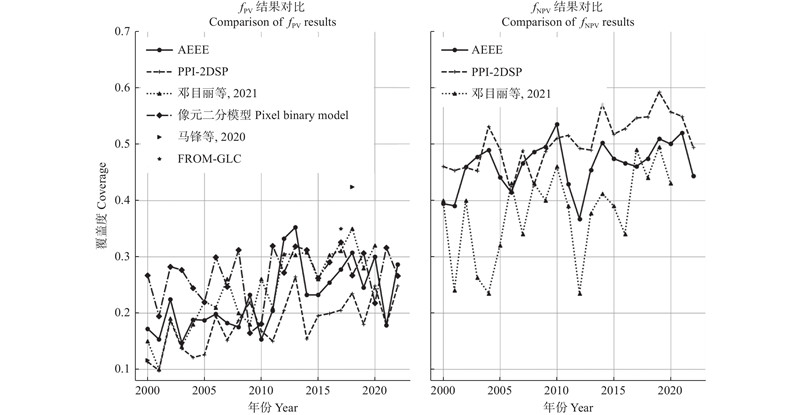
Fig.6
RGB composite map of fractional cover in Shenmu city from 2000 to 2022 Green represents fPV, red represents fNPV, blue represents fBS, and white is the invalid value of the cloud and water mask."
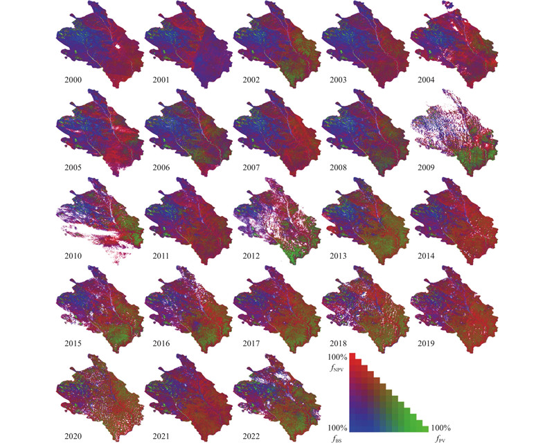
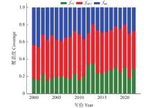
Fig.7
A bar stacked chart depicting fractional cover in Shenmu city from 2000 to 2022 Due to the data collection period being during the peak vegetation growth season (July to September), frequent mutual transitions between fPV and fNPV occur. This leads to an unstable fluctuation in the observed fPV and fNPV in the graph. However, when considering both factors collectively, an overall increasing trend is observed, consistent with findings from other studies."
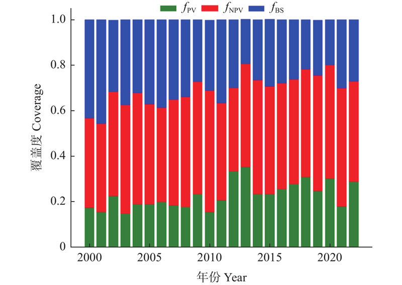
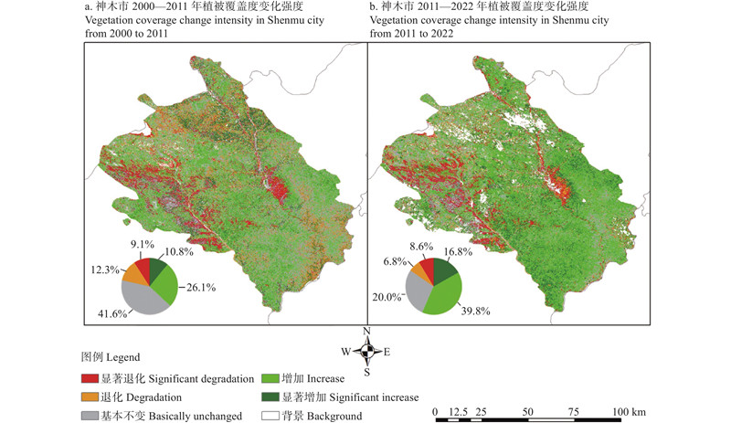
Fig.8
The trend chart depicting the two-stage variation of fractional cover in Shenmu city"
| 柴国奇, 王静璞, 王光镇, 等. 基于MODIS数据的典型草原非光合植被覆盖度估算. 国土资源遥感, 2019, 31 (3): 234- 241. | |
| Chai G Q, Wang J P, Wang G Z, et al. Estimation of fractional cover of non-photosynthetic vegetation in typical steppe based on MODIS data. Remote Sensing for Land & Resources, 2019, 31 (3): 234- 241. | |
| 邓目丽, 蒋馥根, 孙 华, 等. 神木市植被覆盖度时空动态变化分析. 森林与环境学报, 2021, 41 (6): 611- 619. | |
| Deng M L, Jiang F G, Sun H, et al. Spatial-temporal dynamic change analysis of vegetation coverage in Shenmu city. Journal of Forest and Environment, 2021, 41 (6): 611- 619. | |
|
冯正英, 王世东. 结合MNF变换和Canny算子的遥感影像变化检测. 计算机工程与应用, 2019, 55 (14): 266- 270.
doi: 10.3778/j.issn.1002-8331.1803-0452 |
|
|
Feng Z Y, Wang S D. Remote sensing image change detection based on MNF transform and canny operator. Computer Engineering and Applications, 2019, 55 (14): 266- 270.
doi: 10.3778/j.issn.1002-8331.1803-0452 |
|
|
侯春华, 李富平, 冯一帆, 等. 基于NDVI-DFI的矿业开发密集区地表热环境分异效应分析. 农业工程学报, 2020, 36 (3): 160- 168.
doi: 10.11975/j.issn.1002-6819.2020.03.020 |
|
|
Hou C H, Li F P, Feng Y F, et al. Analysis of differentiation effect of surface thermal environment in intensive mining areas based on NDVI-DFI model. Transactions of the Chinese Society of Agricultural Engineering, 2020, 36 (3): 160- 168.
doi: 10.11975/j.issn.1002-6819.2020.03.020 |
|
|
黄健熙, 吴炳方, 曾 源, 等. 水平和垂直尺度乔、灌、草覆盖度遥感提取研究进展. 地球科学进展, 2005, 20 (8): 871- 881.
doi: 10.3321/j.issn:1001-8166.2005.08.008 |
|
|
Huang J X, Wu B F, Zeng Y, et al. Review of tree, shrub, grass cover of horizontal and vertical scale retrieval from remotely sensed data. Advance in Earth Sciences, 2005, 20 (8): 871- 881.
doi: 10.3321/j.issn:1001-8166.2005.08.008 |
|
| 刘逸滨, 刘宝元, 成 城, 等. 退耕还林草20年来榆林市植被覆盖度时空变化及影响因素分析. 水土保持学报, 2022, 36 (2): 197- 208,218. | |
| Liu Y B, Liu B Y, Cheng C, et al. Spatio-temporal changes and influencing factors of vegetation coverage in Yulin city during the past 20 years since the implementation of the “grain for green” program. Journal of Soil and Water Conservation, 2022, 36 (2): 197- 208,218. | |
| 马 锋, 卓 静, 何慧娟, 等. 陕西省榆林市植被生态演变及其驱动机制. 水土保持通报, 2020, 40 (5): 257- 261,267,341. | |
| Ma F, Zhuo J, He H J, et al. Ecological evolution and driving mechanism of vegetation in Yulin city, Shaanxi Province. Bulletin of Soil and Water Conservation, 2020, 40 (5): 257- 261,267,341. | |
| 马建明, 常晓晴, 邢艳秋, 等. 基于Landsat TM/OLI影像的哈尔滨市植被覆盖度与景观格局动态变化分析. 森林工程, 2023, 39 (5): 65- 73. | |
| Ma J M, Chang X Q, Xing Y Q, et al. Analysis of dynamic changes of vegetation coverage and landscape pattern in Harbin based on Landsat TM/OLI images. Forest Engineering, 2023, 39 (5): 65- 73. | |
| 宋吉梅, 夏 楠, 海文月, 等. 基于NDVI-DFI分析新疆戈壁区植被的时空变化. 西南农业学报, 2022, 35 (12): 2867- 2875. | |
| Song J M, Xia N, Hai W Y, et al. Spatial-temporal variation of vegetation in Gobi region of Xinjiang based on NDVI-DFI model. Southwest China Journal of Agricultural Sciences, 2022, 35 (12): 2867- 2875. | |
| 宋清洁, 崔 霞, 张瑶瑶, 等. 基于小型无人机与MODIS数据的草地植被覆盖度研究: 以甘南州为例. 草业科学, 2017, 34 (1): 40- 50. | |
| Song Q J, Cui X, Zhang Y Y, et al. Grassland fractional vegetation cover analysis using small UVAs and MODIS: a case study in Gannan prefecture. Pratacultural Science, 2017, 34 (1): 40- 50. | |
| 王 升, 王全九, 董文财, 等. 黄土坡面不同植被覆盖度下产流产沙与养分流失规律. 水土保持学报, 2012, 26 (4): 23- 27. | |
| Wang S, Wang Q J, Dong W C, et al. Runoff and sediment generations and nutrient losses under different vegetation coverage in loess slope. Journal of Soil and Water Conservation, 2012, 26 (4): 23- 27. | |
| 王光镇, 王静璞, 邹学勇, 等. 基于像元三分模型的锡林郭勒草原光合植被和非光合植被覆盖度估算. 生态学报, 2017, 37 (17): 5722- 5731. | |
| Wang G Z, Wang J P, Zou X Y, et al. Estimation of fractional cover of photosynthetic and non-photosynthetic vegetation in the Xilingol steppe region using the NDVI-DFI model. Acta Ecologica Sinica, 2017, 37 (17): 5722- 5731. | |
| 王光镇. 2018. 锡林郭勒典型草原光合/非光合植被覆盖度遥感估算研究. 烟台: 鲁东大学. | |
| Wang G Z. 2018. Estimating fractional cover of Photosynthetic/non-photosynthetic vegetation in the Xilinguole typical grassland region with remote sensing data. Yantai: Ludong University. [in Chinese] | |
|
卫新东, 林良国, 冯小龙, 等. 榆林市生态安全格局构建与生态问题定量诊断. 生态学报, 2023, 43 (1): 82- 94.
doi: 10.1016/j.chnaes.2021.09.017 |
|
|
Wei X D, Lin L G, Fen X L, et al. Construction of ecological security pattern and quantitative diagnosis of ecological problems in Yulin city. Acta Ecologica Sinica, 2023, 43 (1): 82- 94.
doi: 10.1016/j.chnaes.2021.09.017 |
|
| 吴莉娟. 2015. 基于阴影情况下的植被覆盖度模型研究. 西安: 西安科技大学. | |
| Wu L J. 2015. The study of vegetation coverage model Based on of the shadow. Xi’an: Xi’an University of Science and Technology. [in Chinese] | |
| 余玉洋, 王银苹, 秦 奋, 等. 河南省植被覆盖指数变化及其对气候的响应. 森林与环境学报, 2019, 39 (3): 280- 286. | |
| Yu Y Y, Wang Y P, Qin F, et al. Vegetation index change and its response to climate in Henan Province. Journal of Forest and Environment, 2019, 39 (3): 280- 286. | |
| 云增鑫. 2019. 森林立体分层的激光雷达研究. 南京: 南京大学. | |
| Yun Z X. 2019. Stratifying forest vertical layers using three dimensional (3-D) point cloud data. Nanjing: Nanjing University. [in Chinese] | |
| 张丛凯, 于 颖. ICESat-2/ATLAS数据地面高程及植被冠层高度反演精度验证. 森林工程, 2023, 39 (3): 1- 11. | |
| Zhang C K, Yu Y. Accuracy verification of ground elevation and vegetation canopy height inversion from ICESat-2/ATLAS data. Forest Engineering, 2023, 39 (3): 1- 11. | |
| 张含玉, 方怒放, 史志华. 黄土高原植被覆盖时空变化及其对气候因子的响应. 生态学报, 2016, 36 (13): 3960- 3968. | |
| Zhang H Y, Fang N F, Shi Z H. Spatio-temporal patterns for the NDVI and its responses to climatic factors in the Loess Plateau, China. Acta Ecologica Sinica, 2016, 36 (13): 3960- 3968. | |
|
张兴昌, 刘国彬, 付会芳. 不同植被覆盖度对流域氮素径流流失的影响. 环境科学, 2000, 21 (6): 16- 19.
doi: 10.3321/j.issn:0250-3301.2000.06.004 |
|
|
Zhang X C, Liu G B, Fu H F. Soil nitrogen losses of catchment by water erosion as affected by vegetation coverage. Chinese Journal of Enviromental Science, 2000, 21 (6): 16- 19.
doi: 10.3321/j.issn:0250-3301.2000.06.004 |
|
| 祝 聪, 彭文甫, 张丽芳, 等. 2006—2016年岷江上游植被覆盖度时空变化及驱动力. 生态学报, 2019, 39 (5): 1583- 1594. | |
| Zhu C, Peng W F, Zhang L F, et al. Study of temporal and spatial variation and driving force of fractional vegetation cover in upper reaches of Minjiang River from 2006 to 2016. Acta Ecologica Sinica, 2019, 39 (5): 1583- 1594. | |
|
朱燕香, 潘剑君, 白浩然, 等. 基于Sentinel-2A影像的OPTRAM模型及其改进模型的土壤水分估算研究. 南京农业大学学报, 2020, 43 (4): 682- 689.
doi: 10.7685/jnau.201910012 |
|
|
Zhu Y X, Pan J J, Bai H R, et al. Soil moisture estimation with the OPTRAM model and its improved model based on Sentinel-2A data. Journal of Nanjing Agricultural University, 2020, 43 (4): 682- 689.
doi: 10.7685/jnau.201910012 |
|
|
Cao X, Chen J, Matsushita B, et al. Developing a MODIS-based index to discriminate dead fuel from photosynthetic vegetation and soil background in the Asian steppe area. International Journal of Remote Sensing, 2010, 31 (6): 1589- 1604.
doi: 10.1080/01431160903475274 |
|
|
Daughtry C S T, Hunt E R, McMurtrey J E. Assessing crop residue cover using shortwave infrared reflectance. Remote Sensing of Environment, 2004, 90 (1): 126- 134.
doi: 10.1016/j.rse.2003.10.023 |
|
|
Gitelson A A, Kaufman Y J, Stark R, et al. Novel algorithms for remote estimation of vegetation fraction. Remote Sensing of Environment, 2002, 80 (1): 76- 87.
doi: 10.1016/S0034-4257(01)00289-9 |
|
|
Gong P, Liu H, Zhang M N, et al. Stable classification with limited sample: transferring a 30-m resolution sample set collected in 2015 to mapping 10-m resolution global land cover in 2017. Science Bulletin, 2019, 64 (6): 370- 373.
doi: 10.1016/j.scib.2019.03.002 |
|
|
Graham R L. An efficient algorith for determining the convex hull of a finite planar set. Information Processing Letters, 1972, 1 (4): 132- 133.
doi: 10.1016/0020-0190(72)90045-2 |
|
|
Guerschman J P, Hill M J, Renzullo L J, et al. Estimating fractional cover of photosynthetic vegetation, non-photosynthetic vegetation and bare soil in the Australian tropical savanna region upscaling the EO-1 hyperion and MODIS sensors. Remote Sensing of Environment, 2009, 113 (5): 928- 945.
doi: 10.1016/j.rse.2009.01.006 |
|
|
Mele A, Vitiello A, Bonano M, et al. On the joint exploitation of satellite DInSAR measurements and DBSCAN-based techniques for preliminary identification and ranking of critical constructions in a built environment. Remote Sensing, 2022, 14 (8): 1872.
doi: 10.3390/rs14081872 |
|
|
Towers P C, Poblete-Echeverría C. Effect of the illumination angle on NDVI data composed of mixed surface values obtained over vertical-shoot-positioned vineyards. Remote Sensing, 2021, 13 (5): 855.
doi: 10.3390/rs13050855 |
|
|
Wang G Z, Wang J P, Zou X Y, et al. Estimating the fractional cover of photosynthetic vegetation, non-photosynthetic vegetation and bare soil from MODIS data: assessing the applicability of the NDVI-DFI model in the typical Xilingol grasslands. International Journal of Applied Earth Observation and Geoinformation, 2019, 76, 154- 166.
doi: 10.1016/j.jag.2018.11.006 |
|
| Yan K, Gao S, Chi H J, et al. Evaluation of the vegetation-index-based dimidiate pixel model for fractional vegetation cover estimation. IEEE Transactions on Geoscience and Remote Sensing, 2021, 60, 4400514. | |
|
Zhao T, Bai H Y, Han H Z, et al. A quantitatively divided approach for the vertical belt of vegetation based on NDVI and DEM: an analysis of Taibai Mountain. Forests, 2023, 14 (10): 1981.
doi: 10.3390/f14101981 |
| [1] | Yi Li,Bowen Shan,Li Yang,Jun Qin,Lei Shi. Spatio-Temporal Change of Forest Lands of Feicheng City and Its Driving Factorsin the Past 20 Years [J]. Scientia Silvae Sinicae, 2024, 60(7): 40-46. |
| [2] | Li Zhong,Yunzhi Chen,Xiaoqin Wang. Forest Disturbance Monitoring Based on Time Series of Landsat Data [J]. Scientia Silvae Sinicae, 2020, 56(5): 80-88. |
| [3] | Mao Xuegang, Yao Yao, Fan Wenyi. Extraction of Forest Disturbance Parameters and Estimation of Forest Height Based on Long Time-Series Landsat [J]. Scientia Silvae Sinicae, 2019, 55(3): 79-87. |
| [4] | Li Yangguang, Du Huaqiang, Mao Fangjie, Li Xuejian, Cui Lu, Han Ning, Xu Xiaojun. Information Extracting and Spatiotemporal Evolution of Bamboo Forest Based on Landsat Time Series Data in Zhejiang Province [J]. Scientia Silvae Sinicae, 2019, 55(3): 88-96. |
| [5] | Tian Jing, Xing Yanqiu, Yao Songtao, Zeng Xujing, Jiao Yitao. Comparison of Landsat-TM Image Forest Type Classification Based on Cellular Automata and BP Neural Network Algorithm [J]. Scientia Silvae Sinicae, 2017, 53(2): 26-34. |
| [6] | Xi Zhenyuan, Liu Lijuan, Lu Dengsheng, Ge Hongli, Chen Yaoliang. Mapping of Carya cathayensis Spatial Distribution with Linear Spectral Mixture Model [J]. Scientia Silvae Sinicae, 2015, 51(10): 43-52. |
| [7] | Guo Yun, Li Zengyuan, Chen Erxue, Tian Xin, Ling Feilong. Estimating Forest Above-Ground Biomass in the Upper Reaches of Heihe River Basin Using Multi-Spectral Remote Sensing [J]. Scientia Silvae Sinicae, 2015, 51(1): 140-149. |
| [8] | Zhang Maozhen, Wang Guangxing, Ge Hongli, Xu Lihua. Estimation of Forest Carbon Distribution for Xianju County Based on Spatial Simulation [J]. Scientia Silvae Sinicae, 2014, 50(11): 13-22. |
| [9] | Xu Xiaojun;Zhou Guomo;Du Huaqiang;Dong Dejin;Cui Ruirui;Zhou Yufeng;Shen Zhenming. Estimation of Aboveground Biomass of Phyllostachys praecox Forest Based on Landsat Thematic Mapper Image [J]. Scientia Silvae Sinicae, 2011, 47(9): 1-6. |
| Viewed | ||||||
|
Full text |
|
|||||
|
Abstract |
|
|||||