
Scientia Silvae Sinicae ›› 2024, Vol. 60 ›› Issue (4): 52-61.doi: 10.11707/j.1001-7488.LYKX20220863
Previous Articles Next Articles
Zhuo Chen1,Haiyang Liu1,*,Quanyi Huang1,Mingzhang Zheng2,Jian Li1
Received:2022-12-06
Online:2024-04-25
Published:2024-05-23
Contact:
Haiyang Liu
CLC Number:
Zhuo Chen,Haiyang Liu,Quanyi Huang,Mingzhang Zheng,Jian Li. Simulation of Forest Fire Spread and Optimization of Forest Fire Emergency Prevention Planning[J]. Scientia Silvae Sinicae, 2024, 60(4): 52-61.

Fig.1
Administrative division of Dongchang"


Fig.2
Fire brigade and lookout monitor distribution"

Table 1
General forest fires in Dongchang district of Tonghua city from 2007 to 2018"
| 火灾编号Fire No. | 起火原因 Fire cause | 起火 时间 Fire time | 发现 时间 Discovery time | 扑灭时间 Extinguishing time | 火场总面积Total fire area/ hm2 | 受害成林蓄积量Volume of damaged forest/ m3 | 出动扑火人工 Dispatch fire fighting manpower | 扑火经费 Fire fighting funds/ (104 yuan) |
| 20070427-220502-01 | 农事用火 Farming with fire | 2007?04?27 13:15 | 2007?04?27 13:15 | 2007?04?27 13:40 | 0.15 | 100.00 | 23 | 0.23 |
| 20080419-220502-01 | 农事用火 Farming with fire | 2008?04?19 14:35 | 2008?04?19 14:35 | 2008?04?19 15:00 | 0.43 | 0.00 | 28 | 0.28 |
| 20080422-220502-01 | 火源不明 Unknown fire source | 2008?04?22 02:15 | 2008?04?22 02:15 | 2008?04?22 02:40 | 0.03 | 0.00 | 11 | 0.19 |
| 20100503-220502-01 | 祭祀用火 Sacrifice with fire | 2010?05?03 12:10 | 2010?05?03 12:50 | 2010?05?03 13:20 | 1.24 | 0.00 | 132 | 0.55 |
| 20100509-220502-01 | 祭祀用火 Sacrifice with fire | 2010?05?09 10:50 | 2010?05?09 10:55 | 2010?05?09 11:49 | 0.26 | 190.00 | 76 | 0.31 |
| 20110405-220502-01 | 祭祀用火 Sacrifice with fire | 2011?04?05 13:20 | 2011?04?05 13:25 | 2011?04?05 13:50 | 0.85 | 0.00 | 35 | 0.50 |
| 20140331-220502-01 | 农事用火 Farming with fire | 2014?03?31 14:10 | 2014?03?31 14:20 | 2014?03?31 15:05 | 0.60 | 80.00 | 45 | 0.13 |
| 20140403-220502-01 | 野外吸烟 Wild smoking | 2014?04?03 15:20 | 2014?04?03 15:25 | 2014?04?03 15:57 | 0.50 | 0.00 | 50 | 0.27 |
| 20180430-220502-01 | 野外吸烟 Wild smoking | 2018?04?30 12:50 | 2018?04?30 13:22 | 2018?04?30 14:02 | 0.03 | 0.00 | 20 | 0.26 |

Fig.3
Basic data of FARSITE"
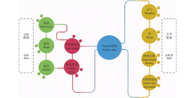

Fig.4
Operation process of FARSITE"
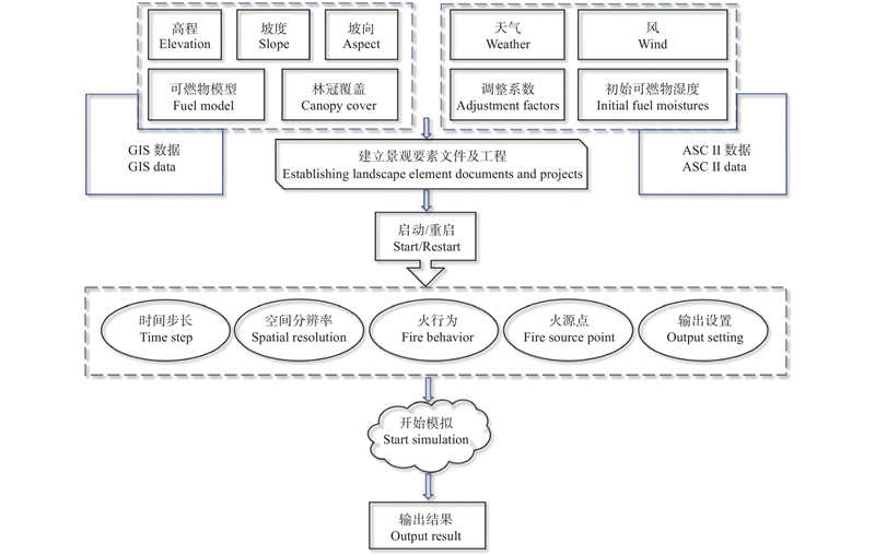

Fig.5
Schematic diagram of single source shortest path method"
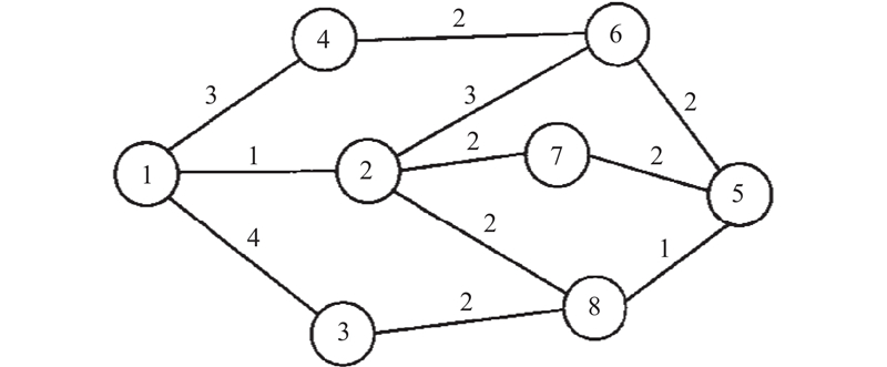

Fig.6
Comparison between paths without priority and paths with priority"


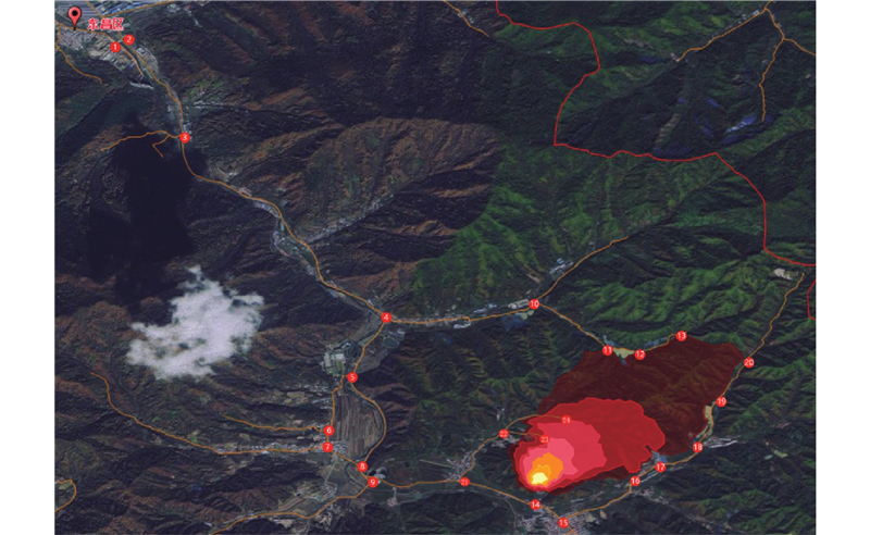
Fig.7
Simulation of "5.3" general forest fire spread in Jinchang Town, Dongchang District in 2010"
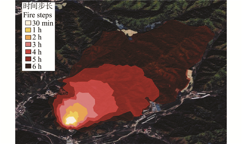

Fig.8
Simulated Rescue Path of "5.3" Fire Spread in Jinchang Town, Dongchang District in 2010"
| 陈 森, 姜 江, 陈英武, 等. 未定路网结构情况下应急物资车辆配送问题模型与应用. 系统工程理论与实践, 2011, 31 (5): 907- 913. | |
| Chen S, Jiang J, Chen Y W, et al. Emergency logistics distribution problem model under uncertain roadway network structure and its application. Systems Engineering-Theory & Practice, 2011, 31 (5): 907- 913. | |
| 韩大校, 韦 睿, 王晓红, 等. 林火导致树木死亡的作用机制和影响因素的研究进展. 林业科学, 2020, 56 (7): 151- 162. | |
| Han D X, Wei R, Wang X H, et al. Progress on the mechanisms and influencing factors of tree mortality caused by forest fire: a review. Scientia Silvae Sinicae, 2020, 56 (7): 151- 162. | |
| 方 祥, 王海晖, 陶骏骏, 等. 林火蔓延过程中辐射换热和点燃特性分析. 林业科学, 2019, 55 (3): 97- 105. | |
| Fang X, Wang H H, Tao J J, et al. Analysis on radiation heat transfer and the ignition associated ignition during forest fire spread. Scientia Silvae Sinicae, 2019, 55 (3): 97- 105. | |
| 葛洪磊, 刘 南. 2014. 复杂灾害情景下应急资源配置的随机规划模型. 系统工程理论与实践, 34(12): 3034−3042. | |
| Ge H L, Liu N. 2014. A stochastic programming model for relief resources allocation problem based on complex disaster scenarios. Systems Engineering-Theory & Practice, 34(12): 3034−3042. [in Chinese] | |
| 黄 辉, 吴 翰, 杨佳祺, 等. 基于实时路况信息的灾后应急配送路径选择系统. 系统管理学报, 2018, 27 (1): 50- 56. | |
| Huang H, Wu H, Yang J, et al. Study on after-disaster emergency relieve supplies transportation route selection system based on real time route information. Journal of Systems & Management, 2018, 27 (1): 50- 56. | |
|
李宗明, 郭 健, 王宇君, 等. 顾及车辆性能的路径规划方法研究. 测绘与空间地理信息, 2020, 43 (11): 100- 105.
doi: 10.3969/j.issn.1672-5867.2020.11.028 |
|
|
Li Z M, Guo J, Wang Y J, et al. Research on path planning method considering vehicle performance. Geomatics & Spatial Information Technology, 2020, 43 (11): 100- 105.
doi: 10.3969/j.issn.1672-5867.2020.11.028 |
|
| 刘志华, 杨 健, 贺红士, 等. 黑龙江大兴安岭呼中林区火烧点格局分析及影响因素. 生态学报, 2011, 31 (6): 1669- 1677. | |
| Liu Z H, Yang J, He H S, et al. Spatial point analysis of fire occurrence and its influence factor in Huzhong forest area of the Great Xing’an Mountains in Heilongjiang Province, China. Acta Ecologica Sinica, 2011, 31 (6): 1669- 1677. | |
| 罗 东, 秦志光, 赵 洋, 等. 基于GIS的应急物资调运信息系统研究. 计算机应用研究, 2011, 28 (6): 2144- 2146,2150. | |
| Luo D, Qin Z G, Zhao Y, et al. Research on emergency material transportation information system based on GIS. Application Research of Computers, 2011, 28 (6): 2144- 2146,2150. | |
| 马宏亮, 张建平, 李瑞敏. 基于动态交通分配的应急路径规划. 交通信息与安全, 2012, 30 (4): 85- 88. | |
| Ma H L, Zhang J P, Li R M. Emergency route planning through dynamic traffic assignment. Journal of Transport Information and Safety, 2012, 30 (4): 85- 88. | |
| 慕安冬, 余世舟. 震后应急期最优路径评估方法. 世界地震工程, 2018, 34 (1): 113- 120. | |
| Mu A D, Yu S Z. Calculation of optimal path in post-earthquake emergency period. World Earthquake Engineering, 2018, 34 (1): 113- 120. | |
| 那顺陶格陶, 吴国周, 代海燕, 等. 基于FARSITE的森林火蔓延模拟研究. 安徽农业科学, 2013, 41 (19): 8203- 8205. | |
| Natao Getao, Wu G Z, Dai H Y, et al. Forest fire spread based on FARSITE. Journal of Anhui Agricultural Sciences, 2013, 41 (19): 8203- 8205. | |
| 苏宝莉, 李 宁. Dijkstra算法优化及在GIS系统中求最佳路径的应用. 遥感技术与应用, 2013, 28 (5): 866- 870. | |
| Su B L, Li N. Dijkstra algorithm and the application of the optimal path in the GIS system. Remote Sensing Technology and Application, 2013, 28 (5): 866- 870. | |
| 唐丽玉, 毛行辉, 陈崇成, 等. 2015. 基于FARSITE的林火蔓延三维可视化模拟. 自然灾害学报, 24(2): 221−227. | |
| Tang L Y , Mao H H, Chen C C, et al. 2013. Three-dimensional visual simulation of forest fire spread based on FARSITE. Journal of Natural Disasters, 24(2): 221−227. [in Chinese] | |
| 陶玉柱, 邸雪颖. 2013. 火对森林土壤微生物群落的干扰作用及其机制研究进展. 林业科学, 49(11): 146−157. | |
| Tao Y Z, Di X Y. 2013. Fire interference on forest soil microbial communities and the mechanism: a review. Scientia Silvae Sinicae, 49(11): 146−157. [in Chinese] | |
| 王晓红, 王千雪, 于宏影, 等. FARSITE模型原理、结构及其在林火行为模拟中的应用. 温带林业研究, 2022, 5 (4): 55- 60. | |
| Wang X H, Wang Q X, Yu H Y, et al. Principle and structure of FARSITE model and its application in simulation of forest fire behavior. Journal of Temperate Forestry Research, 2022, 5 (4): 55- 60. | |
| 吴志伟, 贺红士, 胡远满, 等. FARSITE火行为模型的原理、结构及其应用. 生态学杂志, 2012, 31 (2): 494- 500. | |
| Wu Z W, He H S, Hu Y M, et al. Principle, structure, and application of FARSITE fire behavior model. Chinese Journal of Ecology, 2012, 31 (2): 494- 500. | |
| 肖化顺. 林火管理模糊性术语的界定. 西北林学院学报, 2009, 24 (3): 148- 152. | |
| Xiao H S. Definition of several fire management terminologies. Journal of Northwest Forestry University, 2009, 24 (3): 148- 152. | |
| 杨 斌, 文洪蕊, 李 峰, 等. 突发情景下应急物资分配决策研究. 安全与环境工程, 2015, 22 (5): 7- 12. | |
| Yang B, Wen H R, Li F, et al. Distribution decision on emergency materials in unexpected situation. Safety and Environmental Engineering, 2015, 22 (5): 7- 12. | |
| 曾 伟, 刘祥凤, 杨龙光. 森林火险预报研究进展. 中国林副特产, 2013, (1): 82- 84. | |
| Zeng W, Liu X F, Yang L G. Research progress of forest fire risk forecast. Forest By-Product and Speciality in China, 2013, (1): 82- 84. | |
| 张 杰, 王志勇, 许维胜, 等. 突发事件下应急救援路径选择模型的构建和求解. 计算机应用研究, 2011, 28 (4): 1311- 1314. | |
| Zhang J, Wang Z Y, Xu W S, et al. Model and solution of rescue path selection in emergency. Application Research of Computers, 2011, 28 (4): 1311- 1314. | |
|
Allison R S, Johnston J M, Craig G, et al. Airborne optical and thermal remote sensing for wildfire detection and monitoring. Sensors, 2016, 16 (8): 1310.
doi: 10.3390/s16081310 |
|
| Baker A G, Catterall C. 2016. Managing fire-dependent vegetation in Byron Shire, Australia: are we restoring the keystone ecological process of fire? Ecological Management & Restoration, 17(1): 47–55. | |
|
Bharany S, Sharma S, Frnda J, et al. Wildfire monitoring based on energy efficient clustering approach for FANETS. Drones, 2022, 6 (8): 193.
doi: 10.3390/drones6080193 |
|
| Cao W G, Huang X C, Shu F L. Unmanned rescue vehicle navigation with fused DQN algorithm proceedings of the 2019 international conference on robotics, Intelligent Control and Artificial Intelligence. Shanghai China. ACM, 2019, 6, 556- 561. | |
|
Chen J H, Yang Y, Peng L, et al. Knowledge graph representation learning-based forest fire prediction. Remote Sensing, 2022a, 14 (17): 4391.
doi: 10.3390/rs14174391 |
|
| Chen J H , Zeng S Q, Xu X L. 2022b. Environment-aware path planning for UAV-assisted search and rescue2022 14th international conference on wireless communications and signal processing (WCSP), November 1−3, 2022. Nanjing, China. IEEE, 922−927. | |
| Chen Q, Xu N. 2019. Research on the shortest path analysis method in complex traffic environment based on GIS2019 IEEE 4th advanced information technology, Electronic and Automation Control Conference (IAEAC), December 20−22, 2019. Chengdu, China. IEEE. 208−212. | |
| Cheng X Z, Zhao X Z, Xiao S, et al. 2022. Research on real-time rescue path planning after earthquake based on priority queue. Proc SPIE 12081, Sixth International Conference on Electromechanical Control Technology and Transportation (ICECTT 2021): 925−932. | |
|
Ciesielski M, Balazy R, Borkowski B, et al. Contribution of anthropogenic, vegetation, and topographic features to forest fire occurrence in Poland. IForest - Biogeosciences and Forestry, 2022, 15 (4): 307- 314.
doi: 10.3832/ifor4052-015 |
|
|
Costafreda-Aumedes S, Comas C, Vega-Garcia C. Human-caused fire occurrence modelling in perspective: a review. International Journal of Wildland Fire, 2017, 26 (12): 983.
doi: 10.1071/WF17026 |
|
| Gosiewski Z, Kwaśniewski K. 2020. Time minimization of rescue action realized by an autonomous vehicle. Electronics, 9(12): 2099. | |
| Guo F, Zhang L, Jin S, et al. Modeling anthropogenic fire occurrence in the boreal forest of China usinglogistic regression and random forests. Forests, 2016, 7 (11): 250. | |
|
Guo J, Hou R, Zhou M, et al. Monitoring 2019 forest fires in southeastern Australia with GNSS technique. Remote Sensing, 2021, 13 (3): 386.
doi: 10.3390/rs13030386 |
|
|
Hoekstra A, Buurman J, van Ginkel K C H. Urban water security: a review. Environmental Research Letters, 2018, 13 (5): 053002.
doi: 10.1088/1748-9326/aaba52 |
|
|
Kale M P, Mishra A, Pardeshi S, et al. Forecasting wildfires in major forest types of India. Frontiers in Forests and Global Change, 2022, 5, 882685.
doi: 10.3389/ffgc.2022.882685 |
|
|
Khan S, Khan A. FFireNet: Deep learning based forest fire classification and detection in smart cities. Symmetry, 2022, 14 (10): 2155.
doi: 10.3390/sym14102155 |
|
|
Kumar S, Kumar A. Hotspot and trend analysis of forest fires and its relation to climatic factors in the western Himalayas. Natural Hazards, 2022, 114 (3): 3529- 3544.
doi: 10.1007/s11069-022-05530-5 |
|
|
Kurbanov E, Vorobev O, Lezhnin S, et al. Remote sensing of forest burnt area, burn severity, and post-fire recovery: a review. Remote Sensing, 2022, 14 (19): 4714.
doi: 10.3390/rs14194714 |
|
| Laschi A, Foderi C, Fabiano F, et al. Forest road planning, construction and maintenance to improve forest fire fighting: a review. Croatian Journal of Forest Engineering:Journal for Theory and Application of Forestry Engineering, 2019, 40 (1): 207- 219. | |
|
Li W H, Xu Q L, Yi J H, et al. Predictive model of spatial scale of forest fire driving factors: a case study of Yunnan Province, China. Scientific Reports, 2022a, 12, 19029.
doi: 10.1038/s41598-022-23697-6 |
|
|
Li X L, Vázquez-López A, Sánchez del Río Sáez J, et al. Recent advances on early-stage fire-warning systems: mechanism, performance, and perspective. Nano-Micro Letters, 2022b, 14 (1): 197.
doi: 10.1007/s40820-022-00938-x |
|
| Miezïte L E, Ameztegui A, De Cáceres M, et al. Trajectories of wildfire behavior under climate change. Can forest management mitigate the increasing hazard? Journal of Environmental Management, 2022, 322, 116134. | |
| Ravinandan M E, Prasad E V, Vijaya Kumar M V. 2016. Adaptive path exploration and cognitive map generation using swarm intelligence. 2016 International Conference on Electrical, Electronics, Communication, Computer and Optimization Techniques (ICEECCOT). December 9−10, 2016. Mysuru. IEEE, 318−321. | |
| Mostafa M, Shataee Jouibary S, Lotfalian M, et al. 2017. Watershed road network analysis with an emphasis on fire fighting management. Journal of Environmental Engineering and Landscape Management, 25(4): 342−353. | |
|
Naderpour M, Rizeei H M, Ramezani F. Forest fire risk prediction: a spatial deep neural network-based framework. Remote Sensing, 2021, 13 (13): 2513.
doi: 10.3390/rs13132513 |
|
|
Nebot À, Mugica F. Forest fire forecasting using fuzzy logic models. Forests, 2021, 12 (8): 1005.
doi: 10.3390/f12081005 |
|
|
Parisien M A, Snetsinger S, Greenberg J A, et al. Spatial variability in wildfire probability across the western United States. International Journal of Wildland Fire, 2012, 21 (4): 313- 327.
doi: 10.1071/WF11044 |
|
| Piao Y, Lee D K, Park S, et al. 2022. Multi-hazard mapping of droughts and forest fires using a multi-layer hazards approach with machine learning algorithms. Geomatics, Natural Hazards and Risk, 13(1): 2649−2673. | |
|
Picchio R, Pignatti G, Marchi E, et al. The application of two approaches using GIS technology implementation in forest road network planning in an Italian Mountain Setting. Forests, 2018, 9 (5): 277.
doi: 10.3390/f9050277 |
|
|
Purfürst T. The permanent German forest rescue point system—concept, geographical analysis, and optimisation. Forests, 2022, 13 (2): 197.
doi: 10.3390/f13020197 |
|
|
Shen L, Wang F R, Hu L, et al. Rescue vehicle allocation problem based on optimal reliable path under uncertainty. Journal of Central South University, 2022, 29 (11): 3779- 3792.
doi: 10.1007/s11771-022-5188-1 |
|
|
Shi X L, Gai W M, Xu K. Bi-objective rescue path selection optimization for mine fires based on quantitative risk assessment. Safety Science, 2022, 146, 105492.
doi: 10.1016/j.ssci.2021.105492 |
|
|
Spies T A, Scheller R M, Bolte J P. Adaptation in fire-prone landscapes: interactions of policies, management, wildfire, and social networks in Oregon, USA. Ecology and Society, 2018, 23 (2): 11.
doi: 10.5751/ES-10079-230211 |
|
|
Thompson M P, Gannon B M, Caggiano M D. Forest roads and operational wildfire response planning. Forests, 2021, 12 (2): 110.
doi: 10.3390/f12020110 |
|
|
Thompson M P, Rodríguez y Silva F, Calkin D E, et al. A review of challenges to determining and demonstrating efficiency of large fire management. International Journal of Wildland Fire, 2017, 26 (7): 562- 573.
doi: 10.1071/WF16137 |
|
|
Tian Y P, Wu Z C, Li M Z, et al. Forest fire spread monitoring and vegetation dynamics detection based on multi-source remote sensing images. Remote Sensing, 2022, 14 (18): 4431.
doi: 10.3390/rs14184431 |
|
|
Van Wees D, Van der Werf G R, Randerson J T, et al. The role of fire in global forest loss dynamics. Global Change Biology, 2021, 27 (11): 2377- 2391.
doi: 10.1111/gcb.15591 |
|
| Wang S, Liu B, Liu W P, et al. 2021. Research on the best route strategy model of rescue patrol based on Floyd algorithm2021 7th international conference on hydraulic and civil engineering & smart water conservancy and intelligent disaster reduction forum (ICHCE & SWIDR), November 6-8, 2021. Nanjing, China. IEEE, 48−51. | |
| Wang Z Y, Zlatanova S, Moreno A, et al. A data model for route planning in the case of forest fires. Computers & Geosciences, 2014, 68, 1- 10. | |
|
Wen H Y, Lin Y F, Wu J B. Co-Evolutionary Optimization Algorithm Based on the Future Traffic Environment for Emergency Rescue Path Planning. IEEE Access, 2020, 8, 148125- 148135.
doi: 10.1109/ACCESS.2020.3014609 |
|
|
Wu Z C, Li M Z, Wang B, et al. Analysis of factors related to forest fires in different forest ecosystems in China. Forests, 2022, 13 (7): 1021.
doi: 10.3390/f13071021 |
|
| Yang L H, Li D M, Tan R P, et al. Particle swarm optimization for the shortest path problem. Journal of Intelligent & Fuzzy Systems, 2021, 41 (1): 1353- 1373. | |
| Z Rasel Rahman A K, Nabil Sakif S M, Sikder N, et al. Unmanned aerial vehicle assisted forest fire detection using deep convolutional neural network. Intelligent Automation & Soft Computing, 2023, 35 (3): 3259- 3277. | |
| Zhao M H, Lu J, Hu X J. 2011. A path selection method for traffic accident emergency rescue on expressway network. Proceedings 2011 international conference on transportation, mechanical, and electrical engineering (TMEE), December 16-18, 2011. Changchun, China. IEEE, 1861−1866. | |
|
Zheng S X, Gao P, Zou X J, et al. Forest fire monitoring via uncrewed aerial vehicle image processing based on a modified machine learning algorithm. Fronters in Plant Science, 2022, 13, 954757.
doi: 10.3389/fpls.2022.954757 |
|
|
Zhou J F, Reniers G. Simulation analysis of the use of emergency resources during the emergency response to a major fire. Journal of Loss Prevention in the Process Industries, 2016, 44, 1- 11.
doi: 10.1016/j.jlp.2016.08.007 |
|
|
Zhu Z, Deng X, Zhao F, et al. How environmental factors affect forest fire occurrence in Yunnan forest region. Forests, 2022, 13 (9): 1392.
doi: 10.3390/f13091392 |
| [1] | Li Weike, Shu Lifu, Wang Mingyu, Li Wei, Si Liqing, Zhao Fengjun, Li Xiaoxiao, Zhou Nuanyang. Occurrence Pattern and Changing Trend of Lightning Induced Fires and Human-caused Fires in Daxing’anling Forest Region of Heilongjiang Province [J]. Scientia Silvae Sinicae, 2024, 60(4): 136-146. |
| [2] | Mingyu Wang,Weike Li,Lifu Shu,Liqing Si,Fengjun Zhao,Wei Li,Xiaoxiao Li. Visibility Evaluation of the Lookout Tower Configuration in Huzhong Area Where Lightning Fires Frequently Occur [J]. Scientia Silvae Sinicae, 2023, 59(10): 9-21. |
| [3] | Difei Chen,Mingyu Wang,Liqing Si,Fengjun Zhao,Wei Li,Weike Li,Lifu Shu. Temporal and Spatial Distribution Characteristics and the Influencing Factors of Lightning Fires in Sichuan [J]. Scientia Silvae Sinicae, 2023, 59(10): 32-40. |
| [4] | Wei Li,Lifu Shu,Mingyu Wang,Weike Li,Shangbo Yuan,Liqing Si,Fengjun Zhao,Jiajun Song,Yahui Wang. Temporal and Spatial Distribution and Dynamic Characteristics of Lightning Fires in the Daxing’anling Mountains from 1980 to 2021 [J]. Scientia Silvae Sinicae, 2023, 59(10): 22-31. |
| [5] | Liqing Si,Mingyu Wang,Feng Chen,Lifu Shu,Fengjun Zhao,Weike Li. Distribution Characteristics of Lightning and the Warning of Lightning-Caused Forest Fires [J]. Scientia Silvae Sinicae, 2023, 59(10): 1-8. |
| [6] | Yin Sainan, Shan Yanlong, Chen Xiang, Cao Lili, Yu Bo, Zhang Meiyu. Simulation of the Smoldering Characteristics and Occurrence Probability of Sub-Surface Fires in the Typhoon-Caused Disaster Areas of Changbaishan Mountain with Different Recovery Degrees [J]. Scientia Silvae Sinicae, 2023, 59(9): 117-126. |
| [7] | Chen Bing, Zhao Fengjun, Fan Taiyun, Wu Lijuan, Jiang Zhiquan, Zhao Shuang, Ye Jiangxia. Spatial Distribution of Forest Fire Prevention Comprehensive Obstructing Network in Xichang City [J]. Scientia Silvae Sinicae, 2023, 59(9): 127-138. |
| [8] | Bo Wang,Xueqing Yang,Chunying Jiang,Dong Liu,Feng Chen,Ye Bai,Xiaodong Liu. Forest Fire Spread Risk in Yanqing District of Beijing Based on GIS [J]. Scientia Silvae Sinicae, 2023, 59(8): 90-101. |
| [9] | Xiaorui Tian,Xuezheng Zong,Mingyu Wang. A Review of Recent Progress in Fire Management of Wildland-Urban Interface [J]. Scientia Silvae Sinicae, 2023, 59(6): 149-158. |
| [10] | Fuming Wu,Zhihao Song,Chao Wang,Liyong Fu,Qiaolin Ye. Adaptive Sample Equalization and Information Fusion Augmentation Method for Forest Fire Data [J]. Scientia Silvae Sinicae, 2023, 59(6): 88-101. |
| [11] | Qiangying Jiao,Zongfu Han,Weiye Wang,Di Liu,Pengxu Pan,Bo Li,Nianci Zhang,Ping Wang,Jinhua Tao,Meng Fan. Driving Factors and Forecasting Model of Lightning-Caused Forest Fires in Daxing’ anling Mountains Based on Multi-Sources Data and Machine Learning Method [J]. Scientia Silvae Sinicae, 2023, 59(6): 74-87. |
| [12] | Liqing Si,Shangbo Yuan,Fengjun Zhao,Lifu Shu,Mingyu Wang,Qiming Ma. Relationship between Lightning, Lightning Fire and Human Activities [J]. Scientia Silvae Sinicae, 2022, 58(11): 1-9. |
| [13] | Weike Li,Lifu Shu,Shangbo Yuan,Jiajun Song,Wei Li,Liqing Si,Fengjun Zhao,Yahui Wang,Mingyu Wang. Temporal and Spatial Distribution Characteristics of Lightning in Daxing'anling Mountains Based on VLF/LF 3D Lightning Location System [J]. Scientia Silvae Sinicae, 2022, 58(11): 21-30. |
| [14] | Mingyu Wang,Shangbo Yuan,Wei Li,Weike Li,Jiajun Song,Liqing Si,Yahui Wang,Fengjun Zhao,Xiaorui Tian,Xiaoxiao Li,Lifu Shu. Process and Influencing Factors of Mass Lightning Fires Caused by Dense Lightning in Daxing'anling Mountains [J]. Scientia Silvae Sinicae, 2022, 58(11): 10-20. |
| [15] | Jia Li,Lan Lan,Zuozhong Zhang,Wentao Yuan,Demin Gao,Shuqin Zong,Qiaolin Ye. Inversion Technology of Forest Fuel Moisture Content Based on Deep Learning [J]. Scientia Silvae Sinicae, 2022, 58(10): 47-58. |
| Viewed | ||||||
|
Full text |
|
|||||
|
Abstract |
|
|||||