
Scientia Silvae Sinicae ›› 2024, Vol. 60 ›› Issue (12): 27-34.doi: 10.11707/j.1001-7488.LYKX20240111
Previous Articles Next Articles
Zhongqiu Sun1( ),Xin Ye2,*
Received:2024-02-27
Online:2024-12-25
Published:2025-01-02
Contact:
Xin Ye
E-mail:qiuqiu8708@163.com
CLC Number:
Zhongqiu Sun,Xin Ye. Estimation of Near-Surface Air Temperature in Daxing’anling Mountains Forest Area based on Fengyun-4B Geostationary Meteorological Satellite Data[J]. Scientia Silvae Sinicae, 2024, 60(12): 27-34.
Table 1
FY-4B AGRI sensor parameters"
| 波段 Band | 中心波长 Central wavelength/μm | 波长范围 Wavelength range/μm | 空间分辨率 Spatial resolution/km |
| 1 | 0.47 | 0.45~0.49 | 1 |
| 2 | 0.65 | 0.55~0.75 | 0.5 |
| 3 | 0.825 | 0.750~0.900 | 1 |
| 4 | 1.379 | 1.371~1.386 | 2 |
| 5 | 1.61 | 1.58~1.64 | 2 |
| 6 | 2.25 | 2.10~2.35 | 2 |
| 7 | 3.75 | 3.50~4.00 | 2 |
| 8 | 3.75 | 3.50~4.00 | 4 |
| 9 | 6.25 | 5.80~6.70 | 4 |
| 10 | 6.95 | 6.75~7.15 | 4 |
| 11 | 7.42 | 7.24~7.60 | 4 |
| 12 | 8.55 | 8.30~8.80 | 4 |
| 13 | 10.80 | 10.30~11.30 | 4 |
| 14 | 12.00 | 11.50~12.50 | 4 |
| 15 | 13.3 | 13.00~13.60 | 4 |
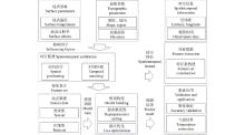
Fig.1
Flowchart of near-surface air temperature estimation method"

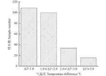
Fig.2
Validation results of the proposed model"

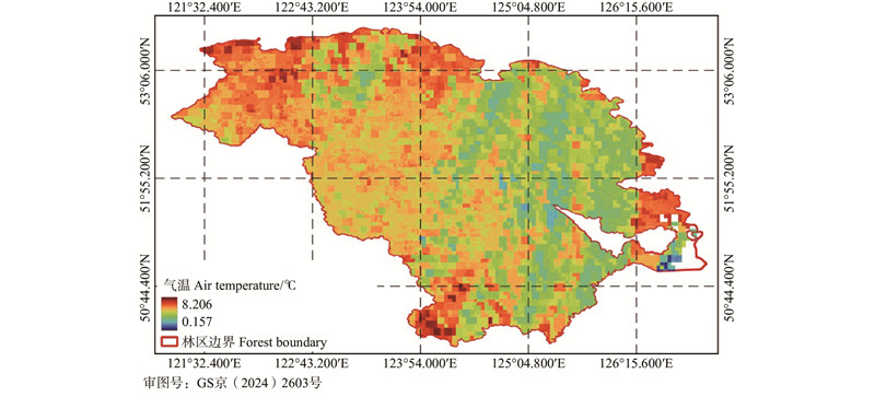
Fig.3
NSAT mapping in the Daxing’anling Mountains forest area"
|
丁利荣, 周 纪, 张晓东, 等. 全天候地表温度遥感获取进展与挑战. 遥感学报, 2023, 27 (7): 1534- 1553.
doi: 10.11834/jrs.20211323 |
|
|
Ding L R, Zhou J, Zhang X D, et al. Estimation of all-weather land surface temperature with remote sensing: progress and challenges. National Remote Sensing Bulletin, 2023, 27 (7): 1534- 1553.
doi: 10.11834/jrs.20211323 |
|
| 杜宝裕. 2023. 基于人工智能和遥感数据的近地表空气温度反演方法研究. 济南: 山东建筑大学. | |
| Du B Y. 2023. Research on inversion method of near-surface air temperature based on artificial intelligence and remote sensing data. Jinan: Shandong Jianzhu University. [in Chinese] | |
| 冯 瑞. 2022. 基于机器学习的西安市近地表气温估算及城市热岛效应研究. 西安: 长安大学. | |
| Feng R. 2022. Near-surface air temperature estimation and urban heat island effect in Xi’an city based on machine learning. Xian: Chang’an University. [in Chinese] | |
| 高亮亮. 2023. 基于集成学习的方面级情感分析的研究与应用. 兰州: 兰州大学. | |
| Gao L L. 2023. Research and application of aspect-level emotion analysis based on integrated learning. Lanzhou: Lanzhou University. [in Chinese] | |
| 郭春霞, 诸云强, 孙 伟. 不同时间尺度、季节的气温数据空间平稳特征及其对插值结果的影响. 地理研究, 2015, 34 (9): 1675- 1684. | |
| Guo C X, Zhu Y Q, Sun W. Analysis of spatial stationary characteristics of air temperature data in different time scales, seasons and its influence on interpolation performance. Geographical Research, 2015, 34 (9): 1675- 1684. | |
| 郭福涛, 苏漳文, 马祥庆, 等. 大兴安岭塔河地区雷击火发生驱动因子综合分析. 生态学报, 2015, 35 (19): 6439- 6448. | |
| Guo F T, Su Z W, Ma X Q, et al. Climatic and non-climatic factors driving lightning-induced fire in Tahe, Daxing’an Mountain. Acta Ecologica Sinica, 2015, 35 (19): 6439- 6448. | |
| 葛玲玲. 2021. 基于机器学习的土壤湿度和气温遥感反演方法研究. 南京: 南京信息工程大学. | |
| Ge L L. 2021. Research on remote sensing inversion method of soil moisture and air temperature based on machine learning. Nanjing: Nanjing University of Information Science & Technology. [in Chinese] | |
| 韩谷怀, 秦其明, 任华忠, 等. 利用AB算法进行高分四号卫星数据反照率反演. 武汉大学学报(信息科学版), 2020, 45 (4): 542- 549. | |
| Han G H, Qin Q M, Ren H Z, et al. Retrieval of GF-4 satellite image data surface albedo based on angular Bin algorithm. Geomatics and Information Science of Wuhan University, 2020, 45 (4): 542- 549. | |
| 华俊玮. 2017. 近地表气温遥感反演及局地高温监测应用研究. 南京: 南京信息工程大学. | |
| Hua J W. 2017. Research on remote sensing inversion of near-surface temperature and application of local high temperature monitoring. Nanjing: Nanjing University of Information Science & Technology. [in Chinese] | |
|
焦强英, 韩宗甫, 王炜烨, 等. 基于多源数据和机器学习方法的大兴安岭地区雷击火驱动因子及火险预测模型. 林业科学, 2023, 59 (6): 74- 87.
doi: 10.11707/j.1001-7488.LYKX20220553 |
|
|
Jiao Q Y, Han Z F, Wang W Y, et al. Driving factors and forecasting model of lightning-caused forest fires in Daxing’anling Mountains based on multi-sources data and machine learning method. Scientia Silvae Sinicae, 2023, 59 (6): 74- 87.
doi: 10.11707/j.1001-7488.LYKX20220553 |
|
| 李思宇, 梁 达, 韦燕芳, 等. 基于贝叶斯网络的干旱-森林火灾灾害链定量建模研究. 自然灾害学报, 2023, 32 (1): 38- 46. | |
| Li S Y, Liang D, Wei Y F, et al. Quantitative modeling of drought-forest fire disaster chain based on the Bayesian network. Journal of Natural Disasters, 2023, 32 (1): 38- 46. | |
| 李秀举, 曹 琦, 周树添, 等. FY-4B GHI长波红外波段的发射前辐射表征和定标. 光学学报, 2023, 43 (12): 163- 174. | |
| Li X J, Cao Q, Zhou S T, et al. Prelaunch radiometric characterization and calibration for long wave infrared band of FY-4B GHI. Acta Optica Sinica, 2023, 43 (12): 163- 174. | |
| 刘 凯, 聂格格, 张 森. 中国1951-2018年气温和降水的时空演变特征研究. 地球科学进展, 2020, 35 (11): 1113- 1126. | |
| Liu K, Nie G G, Zhang S. Study on the spatiotemporal evolution of temperature and precipitation in China from 1951 to 2018. Advances in Earth Science, 2020, 35 (11): 1113- 1126. | |
| 刘林馨, 王 健, 杨晓杰, 等. 大兴安岭不同森林群落植被多样性对土壤有机碳密度的影响. 生态环境学报, 2018, 27 (9): 1610- 1616. | |
| Liu L X, Wang J, Yang X J, et al. Forest plant community and soil organic carbon density in da Xing’an Mountains. Ecology and Environmental Sciences, 2018, 27 (9): 1610- 1616. | |
|
陆忠涛, 侯士彬, 周彦玲, 等. 大兴安岭地区近30a气温变化特征分析. 黑龙江气象, 2023, 40 (2): 22- 24.
doi: 10.3969/j.issn.1002-252X.2023.02.008 |
|
|
Lu Z T, Hou S B, Zhou Y L, et al. Characterization of air temperature changes in the Daxing’anling region in the last 30a. Heilongjiang Meteorology, 2023, 40 (2): 22- 24.
doi: 10.3969/j.issn.1002-252X.2023.02.008 |
|
|
彭 彬, 周艳莲, 高 苹, 等. 气温插值中不同空间插值方法的适用性分析——以江苏省为例. 地球信息科学学报, 2011, 13 (4): 539- 548.
doi: 10.3724/SP.J.1047.2011.00539 |
|
|
Peng B, Zhou Y L, Gao P, et al. Suitability assessment of different interpolation methods in the gridding process of station collected air temperature: a case study in Jiangsu Province, China. Journal of Geo-Information Science, 2011, 13 (4): 539- 548.
doi: 10.3724/SP.J.1047.2011.00539 |
|
| 苏漳文. 2020. 基于地理信息系统的大兴安岭林火发生驱动因子及预测模型的研究. 哈尔滨: 东北林业大学. | |
| Su Z W. 2020. Study on driving factors and prediction model of forest fire in Daxing’anling based on geographic information system. Harbin: Northeast Forestry University. | |
| 孙应龙, 韩佳芮, 延 昊, 等. 我国东北林区夏季森林生态系统服务功能对气候变化的响应研究. 环境生态学, 2023, 5 (3): 36- 42. | |
| Sun Y L, Han J R, Yan H, et al. Response of summer forest ecosystem services to climate change in Northeast China. Environmental Ecology, 2023, 5 (3): 36- 42. | |
| 孙越君, 汪子豪, 秦其明, 等. 高分四号静止卫星数据的地表反照率反演. 遥感学报, 2018, 22 (2): 220- 233. | |
| Sun Y J, Wang Z H, Qin Q M, et al. Retrieval of surface albedo based on GF-4 geostationary satellite image data. Journal of Remote sensing, 2018, 22 (2): 220- 233. | |
|
田宝星, 翟 墨, 杨 帆, 等. 大兴安岭林区生长季气温的变化分析. 黑龙江气象, 2023, 40 (4): 12- 18.
doi: 10.3969/j.issn.1002-252X.2023.04.005 |
|
|
Tian B X, Zhai M, Yang F, et al. Analysis of changes in air temperature during the growing season in the Daxing’anling forest area. Heilongjiang Meteorology, 2023, 40 (4): 12- 18.
doi: 10.3969/j.issn.1002-252X.2023.04.005 |
|
| 王和斌. 2012. 基于风云静止卫星的气温反演研究. 阜新: 辽宁工程技术大学. | |
| Wang H B. 2012. Research on temperature inversion based on FY-geostationary satellite. Fuxin: Liaoning Technical University. [in Chinese] | |
| 王猛猛. 2017. 地表温度与近地表气温热红外遥感反演方法研究. 北京: 中国科学院大学(中国科学院遥感与数字地球研究所). | |
| Wang M M. 2017. Study on thermal infrared remote sensing inversion method of surface temperature and near-surface temperature. Beijing: University of Chinese Academy of Sciences (Institute of Remote Sensing and Digital Earth Chinese Academy of Sciences). | |
|
王文杰, 钱 诚, 张 宇, 等. 1961~2020年中国两大林区森林火险天气的多尺度特征. 气候与环境研究, 2022, 27 (5): 559- 577.
doi: 10.3878/j.issn.1006-9585.2021.21097 |
|
|
Wang W J, Qian C, Zhang Y, et al. Multi-time scale features of fire weather in two major forests in China during 1961–2020. Climatic and Environmental Research, 2022, 27 (5): 559- 577.
doi: 10.3878/j.issn.1006-9585.2021.21097 |
|
| 徐化成. 1998. 中国大兴安岭森林. 北京: 科学出版社. | |
| Xu H C. 1998. The forests of Daxing’anling mountain, China. Beijing: Science Press. [in Chinese] | |
|
徐继伟, 杨 云. 集成学习方法: 研究综述. 云南大学学报(自然科学版), 2018, 40 (6): 1082- 1092.
doi: 10.7540/j.ynu.20180455 |
|
|
Xu J W, Yang Y. A survey of ensemble learning approaches. Journal of Yunnan University (Natural Science Edition), 2018, 40 (6): 1082- 1092.
doi: 10.7540/j.ynu.20180455 |
|
|
张宏鸣, 刘 雯, 韩文霆, 等. 基于梯度提升树算法的夏玉米叶面积指数反演. 农业机械学报, 2019, 50 (5): 251- 259.
doi: 10.6041/j.issn.1000-1298.2019.05.029 |
|
|
Zhang H M, Liu W, Han W T, et al. Inversion of summer maize leaf area index based on gradient boosting decision tree algorithm. Transactions of the Chinese Society for Agricultural Machinery, 2019, 50 (5): 251- 259.
doi: 10.6041/j.issn.1000-1298.2019.05.029 |
|
| 张悦琦, 任鸿瑞. 融合特征优选与随机森林算法的GF-6影像东北一季稻遥感提取. 遥感学报, 2023, 27 (9): 2153- 2164. | |
| Zhang R Q, Ren H R. Remote sensing extraction of paddy rice in Northeast China from GF-6 images by combining feature optimization and random forest. Journal of Remote Sensing, 2023, 27 (9): 2153- 2164. | |
| Ding B S, Zhang R H, Xu L X, et al. U2D2Net: unsupervised unified image dehazing and denoising network for single hazy image enhancement. IEEE Transactions on Multimedia, 2023, 26, 202- 217. | |
| Hou P, Chen Y H, Qiao W, et al. Near-surface air temperature retrieval from satellite images and influence by wetlands in urban region. Theoretical and Applied Climatology, 2013, 111 (1): 109- 118. | |
|
Sun Y J, Wang J F, Zhang R H, et al. Air temperature retrieval from remote sensing data based on thermodynamics. Theoretical and Applied Climatology, 2005, 80 (1): 37- 48.
doi: 10.1007/s00704-004-0079-y |
|
|
Thongsuwan S, Jaiyen S, Padcharoen A, et al. ConvXGB: a new deep learning model for classification problems based on CNN and XGBoost. Nuclear Engineering and Technology, 2021, 53 (2): 522- 531.
doi: 10.1016/j.net.2020.04.008 |
|
|
Ye X, Liu R Y, Hui J, et al. Land surface temperature estimation from landsat-9 thermal infrared data using ensemble learning method considering the physical radiance transfer process. Land, 2023, 12 (7): 1287.
doi: 10.3390/land12071287 |
|
| Zhang R H, Cao Z, Yang S, et al. 2024. Cognition-driven structural prior for instance-dependent label transition matrix estimation. IEEE Transactions on Neural Networks and Learning Systems, 1−14. doi: 10.1109/TNNLS.2023.3347633. | |
| Zhang R H, Xu L X, Yu Z Y, et al. Deep-IRTarget: an automatic target detector in infrared imagery using dual-domain feature extraction and allocation. IEEE Transactions on Multimedia, 2021, 24, 1735- 1749. | |
|
Zhang R H, Yang S, Zhang Q, et al. Graph-based few-shot learning with transformed feature propagation and optimal class allocation. Neurocomputing, 2022, 470, 247- 256.
doi: 10.1016/j.neucom.2021.10.110 |
| [1] | Wei Li,Lifu Shu,Mingyu Wang,Weike Li,Shangbo Yuan,Liqing Si,Fengjun Zhao,Jiajun Song,Yahui Wang. Temporal and Spatial Distribution and Dynamic Characteristics of Lightning Fires in the Daxing’anling Mountains from 1980 to 2021 [J]. Scientia Silvae Sinicae, 2023, 59(10): 22-31. |
| [2] | Zhao Xiaodi, Li Lingchao, Yang Wentao, Cheng Baodong, Liu Jinlong. Analysis of Socio-Economic Influencing Factors of Forest Transition in Counties of Fujian Province [J]. Scientia Silvae Sinicae, 2019, 55(8): 147-156. |
| [3] | Zhang Yuxing, Wang Xuejun, Huang Guosheng, Dang Yongfeng, Chen Xinyun. Forest Area Remote Sensing Monitoring Using the Multi-Level Sampling Interpretation Approach [J]. Scientia Silvae Sinicae, 2017, 53(7): 94-104. |
| [4] | Zhu Zhenfeng, Cao Yukun. Pseudo Decoupling Risk of Economic Growth and Resource Consumption Identifying and Cracking in the National Forestry Area [J]. Scientia Silvae Sinicae, 2017, 53(4): 139-149. |
| [5] | Zhang Zhanzhen;Wang Zhaojun;. Empirical Analysis of Forestry Industrial Concentration Level in Northeast State-Owned Forest Area [J]. Scientia Silvae Sinicae, 2011, 47(5): 112-116. |
| [6] | Liu Yanchun;Shi Ying . Development Course of Forest Harvesting Management Techniques of the Key State Owned Forest Areas in Jilin Province [J]. Scientia Silvae Sinicae, 2008, 44(6): 180-180. |
| [7] | He Haoran;Weng Qian;Xu Jintao. Analysis on the Efficiency of Processing Mills in State-Owned Forest Areas [J]. Scientia Silvae Sinicae, 2007, 43(11): 113-121. |
| [8] | Xu Xiuying;Ma Tianle;Liu Junchang. Study on Forest Property Rights System Reform in Collective Forest Area of South China [J]. Scientia Silvae Sinicae, 2006, 42(8): 121-129. |
| [9] | Li Jingwen;Nie Shaoquan;An Binhe. Stump Sprouting of the Main Broad-Leaved Tree Species of Secondary Forestin Eastern Area of Northeast China [J]. Scientia Silvae Sinicae, 2005, 41(6): 72-77. |
| [10] | Wan Zhifang;Geng Yude;. Study on Reconstruction Forestry Micro-Main Body of the State-Owned Forest Area [J]. Scientia Silvae Sinicae, 2005, 41(1): 148-156. |
| Viewed | ||||||
|
Full text |
|
|||||
|
Abstract |
|
|||||