
Scientia Silvae Sinicae ›› 2021, Vol. 57 ›› Issue (1): 85-94.doi: 10.11707/j.1001-7488.20210109
Previous Articles Next Articles
Langning Huo,Xiaoli Zhang*
Received:2019-03-01
Online:2021-01-25
Published:2021-03-10
Contact:
Xiaoli Zhang
CLC Number:
Langning Huo,Xiaoli Zhang. Individual Tree Information Extraction and Accuracy Evaluation Based on Airborne LiDAR Point Cloud by Multilayer Clustering Method[J]. Scientia Silvae Sinicae, 2021, 57(1): 85-94.
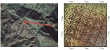
Fig.1
Position of the study area and the super plot layout presenting in point cloud"

Table 1
The stand information of the super plot"
| 树高 最大值 Maximum height/m | 树高 最小值 Minimum height/m | 树高 均值 Mean height/m | 冠幅加权 平均树高 Average height weighted by crown diameter/m | 冠幅 最大值 Maximum crown diameter/m | 冠幅 最小值 Minimum crown diameter/m | 冠幅 均值 Mean crown diameter/m |
| 33.80 | 2.00 | 9.29 | 10.92 | 9.05 | 0.50 | 3.22 |
| 郁闭度 Canopy closure | 株数密度 Stem density/ hm-2 | 树高基尼指数 Gini coefficient | 树高变异系数 Coefficient of variation | 聚集指数 Aggregation index | 最邻近体间平均距离 Mean distance between the nearest neighbors/m | |
| 0.70 | 1 435 | 0.35 | 55.20 | 0.99 | 1.31 | |
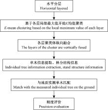
Fig.2
The framework for clustering with slicing horizontal layers"


Fig.3
The slicing of horizontal layers and extraction of the positions of the local maximums"
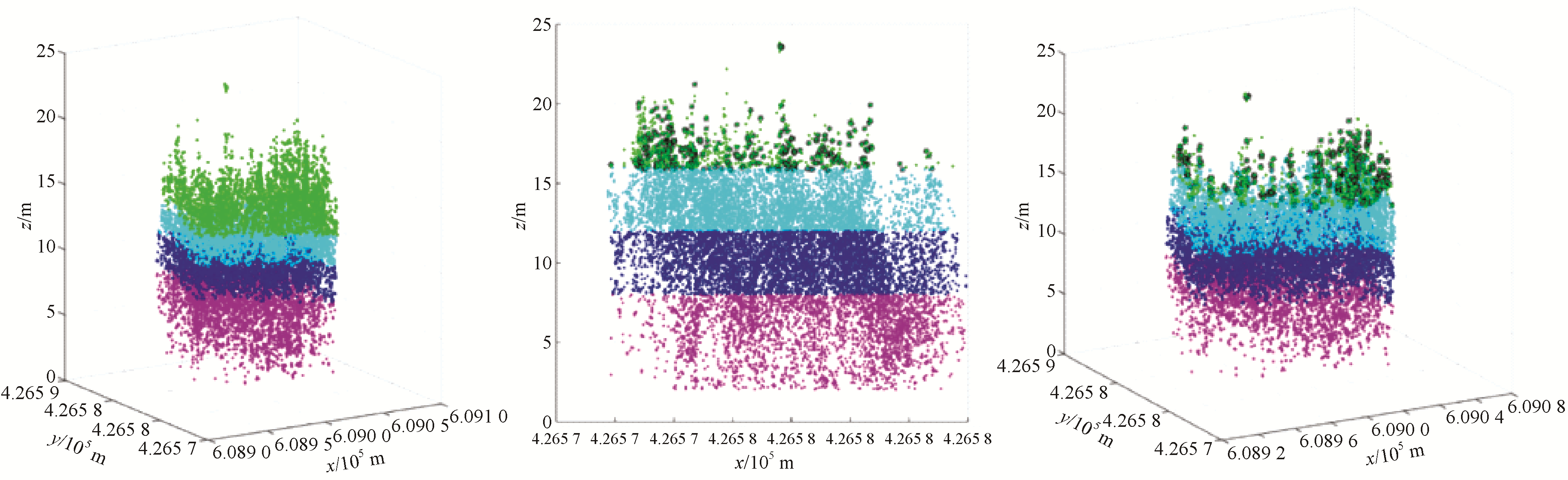
Table 2
The parameters and their abbreviation used in this paper"
| 参数名称 Parameter name | LiDAR提取木 Test trees from LiDAR data | 实际对照木 Reference trees | 精度 Accuracy |
| 单木树高Individual tree height | h_test | h_ref | A_h |
| 单木冠幅Individual tree crown diameter | c_test | c_ref | A_c |
| 林分平均高(冠幅加权平均树高) Mean height of the stands (average height weighted by crown diameter) | H_test | H_ref | A_H |
| 林木数量Number of trees | N_test | N_ref | N_match |
| 树高基尼指数Gini coefficient | Gc_test | Gc_ref | A_Gc |
| 树高变异系数Coefficient of variation | Cv_test | Cv_ref | A_Cv |
| 最邻近体间平均距离 Mean distance between the nearest neighbors | r_test | r_ref | A_r |
| 聚集指数Aggregation index | R_test | R_ref | A_R |
| 树高分布均方根误差RMSE of tree height | RMSE_H | ||
| 冠幅分布均方根误差RMSE of crown diameter | RMSE_C | ||
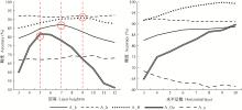
Fig.4
Effect of different slicing methods on accuracy"
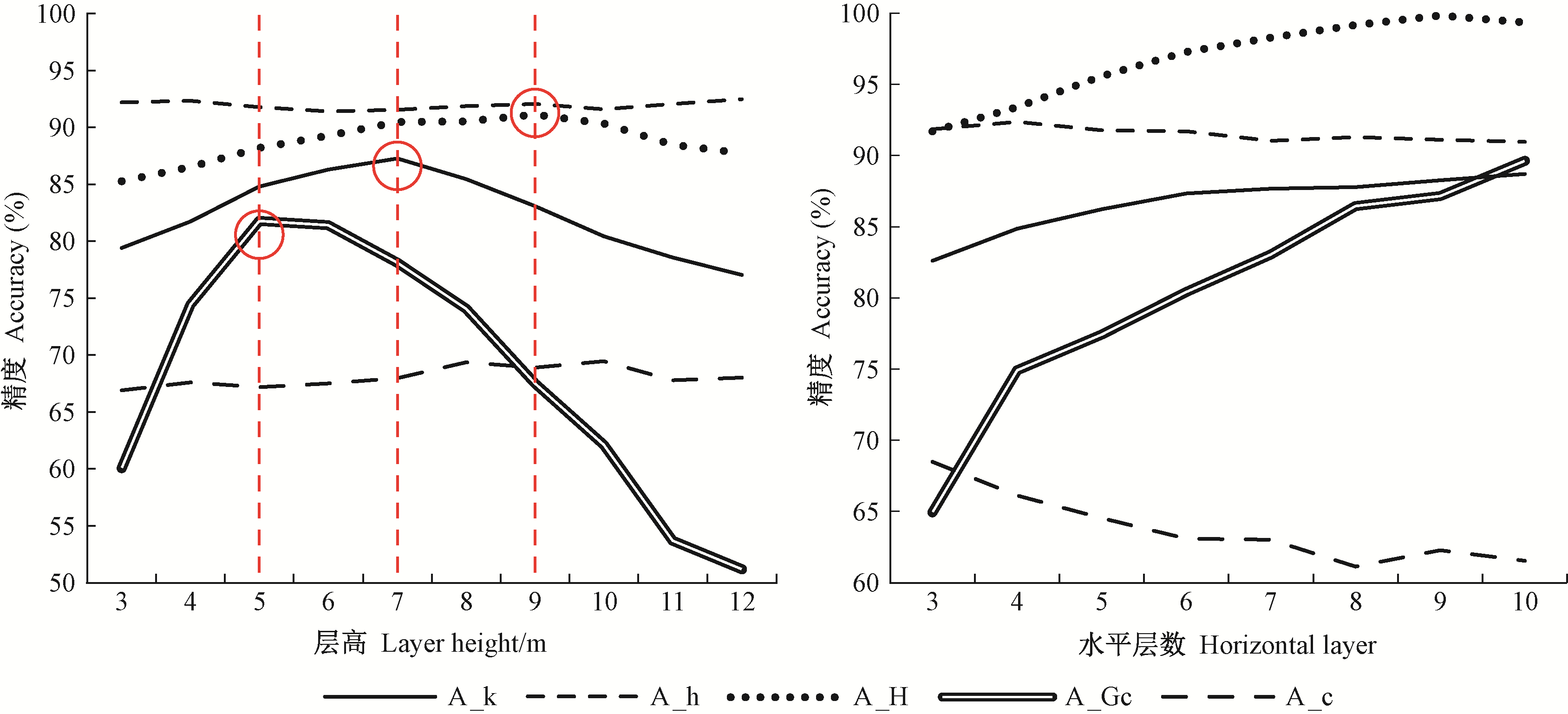
Table 3
Effect of slice number setting on clustering effect and accuracy"
| 分层数 Number of slices | A_k(%) | 单木信息精度 Accuracy of individual tree information | 林分结构信息精度 Accuracy of forest structure information | ||||||
| A_h(%) | A_c(%) | A_H(%) | RMSE_H | RMSE_C | A_Gc(%) | A_Cv(%) | |||
| 3 | 82.61 | 91.85 | 68.51 | 91.73 | 66.88 | 139.26 | 64.93 | 65.38 | |
| 4 | 84.86 | 92.38 | 66.13 | 93.40 | 59.68 | 132.73 | 74.94 | 75.04 | |
| 5 | 86.24 | 91.80 | 64.52 | 95.60 | 48.04 | 128.54 | 77.45 | 77.31 | |
| 6 | 87.35 | 91.73 | 63.10 | 97.31 | 46.17 | 126.33 | 80.45 | 80.25 | |
| 7 | 87.69 | 91.05 | 63.02 | 98.29 | 39.93 | 121.44 | 83.05 | 82.72 | |
| 8 | 87.80 | 91.30 | 61.12 | 99.18 | 43.85 | 119.26 | 86.45 | 86.11 | |
| 9 | 88.28 | 91.12 | 62.27 | 99.84 | 33.94 | 114.75 | 87.15 | 86.56 | |
| 10 | 88.70 | 90.99 | 61.56 | 99.37 | 29.53 | 111.68 | 89.65 | 89.23 | |
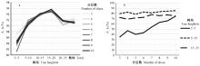
Fig.5
Effect of slice number on individual tree height accuracy and clustering effect"
Fig.6
Extraction efficiency at each tree height level with 3-12 m layer height"

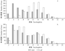
Fig.7
The comparison of height distribution of trees derived from LiDAR and reference data"

| 尹艳豹. 2010. 基于机载激光雷达测量的森林资源调查因子联立估计研究. 北京: 中国林业科学研究院博士学位论文. | |
| Yin Y B. 2010. Study on simultaneous estimation of forest resource survey factors based on airborne LiDAR measurement data. Beijing: PhD thesis of Chinese Academy of Forestry.[in Chinese] | |
|
Clark P J , Evans F C . Distance to nearest neighbor as a measure of spatial relationships in populations. Ecology, 1954, 35, 445- 453.
doi: 10.2307/1931034 |
|
|
Ene L , Næsset E , Gobakken T . Single tree detection in heterogeneous boreal forests using airborne laser scanning and area-based stem number estimates. International Journal of Remote Sensing, 2012, 33, 5171- 5193.
doi: 10.1080/01431161.2012.657363 |
|
|
Eysn L , Hollaus M , Lindberg E , et al. A benchmark of LiDAR based single tree detection methods using heterogeneous forest data from the Alpine space. Forests, 2015, 6, 1721- 1747.
doi: 10.3390/f6051721 |
|
|
Ferraz A , Bretar F , Jacquemoud S , et al. 3-D mapping of a multi-layered mediterranean forest using ALS data. Remote Sensing of Environment, 2012, 121, 210- 223.
doi: 10.1016/j.rse.2012.01.020 |
|
| Gini C . Variabilità e mutabilità contributo llo studio delle distribuzioni e delle relazioni statistiche. Studi Economico-Giuridici dell' Universiti di Cagliari, 1912, 3 (2): 1- 158. | |
|
Gupta S , Weinacker H , Koch B . Comparative analysis of clustering-based approaches for 3-D single tree detection using airborne fullwave LiDAR data. Remote Sensing, 2010, 2, 968- 989.
doi: 10.3390/rs2040968 |
|
|
Hansen E H , Gobakken T , Næsset E . Effects of pulse density on digital terrain models and canopy metrics using airborne laser scanning in a tropical rainforest. Remote Sensing, 2015, 7, 8453- 8468.
doi: 10.3390/rs70708453 |
|
| Hyyppä J , Inkinen M . Detecting and estimating attributes for single trees using laser scanner. The Photogrammetric Journal of Finland, 1999, 16, 27- 42. | |
|
Hyyppä J , Kelle O , Lehikoinen M , et al. A segmentation-based method to retrieve stem volume estimates from 3-D tree height models produced by laser scanners. IEEE Transactions on Geoscience and Remote Sensing, 2001, 39, 969- 975.
doi: 10.1109/36.921414 |
|
|
Hyyppä J , Yu X , Hyyppä H , et al. Advances in forest inventory using airborne laser scanning. Remote Sensing, 2012, 4, 1190- 1207.
doi: 10.3390/rs4051190 |
|
|
Kaartinen H , Hyyppä J , Yu X , et al. An international comparison of individual tree detection and extraction using airborne laser scanning. Remote Sensing, 2012, 4, 950- 974.
doi: 10.3390/rs4040950 |
|
|
Kandare K , Orka H O , Chan J C W , et al. Effects of forest structure and airborne laser scanning point cloud density on 3D delineation of individual tree crowns. European Journal of Remote Sensing, 2016, 49, 337- 359.
doi: 10.5721/EuJRS20164919 |
|
|
Lee H , Slatton K C , Roth B E , et al. Adaptive clustering of airborne LiDAR data to segment individual tree crowns in managed pine forests. International Journal of Remote Sensing, 2010, 31, 117- 139.
doi: 10.1080/01431160902882561 |
|
| Li W , Guo Q , Jakubowski M K , et al. A new method for segmenting individual trees from the LiDAR point cloud. Photogrammetric Engineering & Remote Sensing, 2012, 78 (1): 75- 84. | |
|
Magnussen S , Næsset E , Gobakken T . Reliability of LiDAR derived predictors of forest inventory attributes: a case study with Norway spruce. Remote Sensing of Environment, 2010, 114, 700- 712.
doi: 10.1016/j.rse.2009.11.007 |
|
|
Morsdorf F , Meier E , Kötz B , et al. LiDAR based geometric reconstruction of boreal type forest stands at single tree level for forest and wildland fire management. Remote Sensing of Environment, 2004, 92, 353- 362.
doi: 10.1016/j.rse.2004.05.013 |
|
|
Næsset E . Predicting forest stand characteristics with airborne scanning laser using a practical two-stage procedure and field data. Remote Sensing of Environment, 2002, 80, 88- 99.
doi: 10.1016/S0034-4257(01)00290-5 |
|
|
Packalen P , Strunk J L , Pitkänen J A , et al. Edge-tree correction for predicting forest inventory attributes using area-based approach with airborne laser scanning. IEEE Journal of Selected Topics in Applied Earth Observations and Remote Sensing, 2015, 8, 1274- 1280.
doi: 10.1109/JSTARS.2015.2402693 |
|
|
Pedersen R Ø , Bollandsås O M , Gobakken T , et al. Deriving individual tree competition indices from airborne laser scanning. Forest Ecology and Management, 2012, 280, 150- 165.
doi: 10.1016/j.foreco.2012.05.043 |
|
|
Reitberger J , Schnörr C , Krzystek P , et al. 3D segmentation of single trees exploiting full waveform LiDAR data. ISPRS Journal of Photogrammetry and Remote Sensing, 2009, 64, 561- 574.
doi: 10.1016/j.isprsjprs.2009.04.002 |
|
| Solberg S , Næsset E , Bollandsås O M . Single tree segmentation using airborne laser scanner data in a structurally heterogeneous spruce forest. Photogrammetric Engineering & Remote Sensing, 2006, 72, 1369- 1378. | |
|
Tang F F , Zhang X H , Liu J N . Segmentation of tree crown model with complex structure from airborne LiDAR data. Geoinformatics 2007:Remotely Sensed Data and Information, 2007, 67520A
doi: 10.1117/12.760476 |
|
|
Tang S , Dong P , Buckles B P . Three-dimensional surface reconstruction of tree canopy from LiDAR point clouds using a region-based level set method. International Journal of Remote Sensing, 2013, 34, 1373- 1385.
doi: 10.1080/01431161.2012.720046 |
|
|
Yao W , Krull J , Krzystek P , et al. Sensitivity analysis of 3D individual tree detection from LiDAR point clouds of temperate forests. Forests, 2014, 5, 1122- 1142.
doi: 10.3390/f5061122 |
| [1] | Wang Liqun, Zhang Zhiqiang, Li Ge, Ma Fengwei, Chen Lixin. A Preliminary Analysis about the Structure, Change and Ecological Benefits of Village Human Habitat Forests in Beijing Fringe Area: A Case Study in Niulanshan-Mapo Town [J]. Scientia Silvae Sinicae, 2018, 54(8): 142-152. |
| [2] | You Haotian, Xing Yanqiu, Peng Tao, Ding Jianhua. Research on the Effect of Side-Overlap between Airborne LiDAR Adjacent Swaths on the Coniferous Forest Structural Parameters Estimation [J]. Scientia Silvae Sinicae, 2018, 54(6): 109-118. |
| [3] | Li Pinghao, Shen Xin, Dai Jinsong, Cao Lin. Comparisons and Accuracy Assessments of LiDAR-Based Tree Segmentation Approaches in Planted Forests [J]. Scientia Silvae Sinicae, 2018, 54(12): 127-136. |
| [4] | Li Tingting, Lu Yuanchang, Pang Lifeng, Zhang Xianqiang, Wang Xia, Liu Xianzhao, Jiang Jun. Initial Effect of Close-to-Nature Management of Chinese Fir Plantation [J]. Scientia Silvae Sinicae, 2014, 50(5): 90-100. |
| [5] | Cao Lin, Dai Jinsong, Pang Yong, Zhao Bing, Xu Jianxin, Li Zengyuan. Estimation of Urban Building Rooftop-Received Solar Energy by LiDAR and Irradiation Model in the Urban Vegetation Shading Environment [J]. Scientia Silvae Sinicae, 2014, 50(2): 99-110. |
| [6] | Yin Yanbao;Tang Shouzheng;Lang Pumei;Gao Ruixin. Determination of DEM Based on Multiple-Echo Data of Airborne LiDAR in Mountainous Wooded Area Using Discriminant Analysis [J]. Scientia Silvae Sinicae, 2011, 47(12): 106-113. |
| [7] | Tang Mengping. Advances in Study of Forest Spatial Structure [J]. Scientia Silvae Sinicae, 2010, 46(1): 117-122. |
| [8] | Tang Xiaoming;Yu Zhengzhong;Wu Yan. PROBING INTO OPTIMAL FOREST STRUCTURE OF EVENAGED STANDS [J]. , 1989, 25(5): 439-446. |
| Viewed | ||||||
|
Full text |
|
|||||
|
Abstract |
|
|||||