
Scientia Silvae Sinicae ›› 2026, Vol. 62 ›› Issue (6): 82-95.doi: 10.11707/j.1001-7488.LYKX20250578
• Research papers • Previous Articles Next Articles
Yunhe Li1,2,Sirong Wang3,Yisa Li1,2,Dengsheng Lu1,2,*( )
)
Received:2025-09-19
Revised:2026-03-22
Online:2026-06-10
Published:2026-06-13
Contact:
Dengsheng Lu
E-mail:ludengsheng@fjnu.edu.cn
CLC Number:
Yunhe Li,Sirong Wang,Yisa Li,Dengsheng Lu. Comparative Analysis of Individual Tree Parameter Extraction Accuracy Using Integrated Data Collected by Airborne and Handheld LiDAR in Subtropical Typical Forests[J]. Scientia Silvae Sinicae, 2026, 62(6): 82-95.
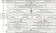
Fig.1
Framework of extracting individual tree parameters from handheld and airborne LiDAR data"
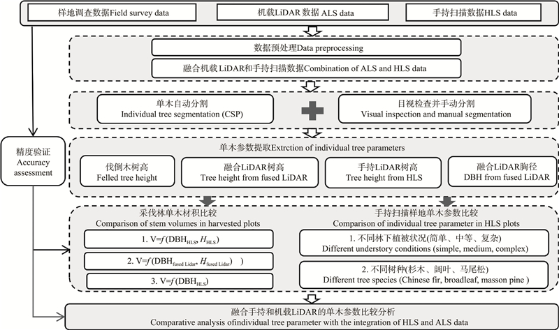
Table 1
Datasets used in research"
| 数据类型 Data type | 内容描述 Descriptions | 获取时间 Acquisition time | 用途 Purpose | |||||
| 研究区域 Study area | 林分类型 (样地数量) Forest types (number of plots) | 样地总株数Total number of stems | 实测株数Number of measured stems | 平均胸径 Average DBH/cm | 平均树高 Average tree height/m | |||
| 采伐样地内单木量测 Individual tree measurement in harvested plots | 白砂国有林场 Baisha State-Owned Forest Farm | 马尾松(1)Masson pine | 72 | 72 | 14.4 | 13.5 | 2024?02 | 基于融合LiDAR提取的单木参数的精度验证 Accuracy validation of individual tree parameters extracted from fused LiDAR data |
| 杉木(1) Chinese fir | 45 | 45 | 12.2 | 9.5 | ||||
| 手持扫描样地内单木 量测 Individual tree measurement in HLS plots | 白砂国有林场 Baisha State-Owned Forest Farm | 马尾松(4) Masson pine | 352 | 28 | 15.5 | \ | 2022?10?11 | 基于融合LiDAR数据,对手持扫描样地中不同林分类型和林下植被状况的单木参数提取结果进行精度验证和比较分析 Accuracy validation and comparative analysis of individual tree parameter extraction results for different forest types and understory conditions in HLS plots based on fused LiDAR data |
| 杉木(1)Chinese fir | 75 | 75 | 14.0 | \ | ||||
| 阔叶(2)Broadleaf | 70 | 52 | 16.1 | \ | ||||
| 水西国有林场 Shuixi State-Owned Forest Farm | 杉木(4)Chinese fir | 156 | 156 | 23.5 | \ | 2023?02 | ||
| 武夷山 国家公园 Wuyishan National Forest Park | 马尾松(2)Masson pine | 135 | 105 | 21.9 | \ | 2023?08 | ||
| 杉木(5)Chinese fir | 335 | 335 | 16.8 | \ | ||||
| 阔叶(4)Broadleaf | 306 | 74 | 12.3 | \ | ||||
| 手持激光扫描数据 HLS data | 白砂国有林场 手持扫描样地 HLS plots in Baisha State-Owned Forest Farm | HLS数据使用LiGripH120传感器采集,扫描视场角为280°× 360°,LiDAR测距精度可达到±3 cm,点频320 000 pts·s?1, 测量范围为120 m HLS data are acquired using LiGripH120 laser sensor. The device has a field of view of 280°×360°, LiDAR ranging accuracy reached up to ±3 cm, measuring up to 320 000 pts·s?1 in a single return mode within a maximum range of 120 m | 2022?10?11 | 单独基于手持扫描数据以及融合机载LiDAR数据提取采伐林与手持扫描样地单木参数 Individual tree parameters extracted separately from HLS data and fused LiDAR data in the harvested and HLS plots | ||||
| 白砂国有林场采伐林 Harvested stands in Baisha State-Owned Forest Farm | 2024?02 | |||||||
| 水西国有林场 Shuixi State-Owned Forest Farm | 2023?02 | |||||||
| 武夷山 国家公园 Wuyishan National Forest Park | 2023?08 | |||||||
| 机载激光扫描数据 ALS data | 白砂国有林场 Baisha State-Owned Forest Farm | 利用AEROS-912动力三角翼飞机搭载Riegl VUX-240机载激光雷达系统采集LiDAR数据,视场角75°,LiDAR测距精度可达到 0.2 cm,点云密度高于40 pt·m?2 LiDAR data are acquired using AEROS-912 aircraft equipped with a Riegl VUX-240 LiDAR system. The LiDAR system has a field of view of 75° and a ranging precision of up to 0.2 cm. The average point density is over 40 pt·m?2 | 2022?10?11 | 融合手持扫描数据提取采伐林与手持扫描样地单木参数 Extraction of individual tree parameters in harvested and HLS plots using fused LiDAR data | ||||
| 水西国有林场 Shuixi State-Owned Forest Farm | 2023?10 | |||||||
| 武夷山 国家公园 Wuyishan National Forest Park | 2022?12 | |||||||

Fig.2
The workflow for calculation of understory complexity index (UCI) based on fused LiDAR point clouds"
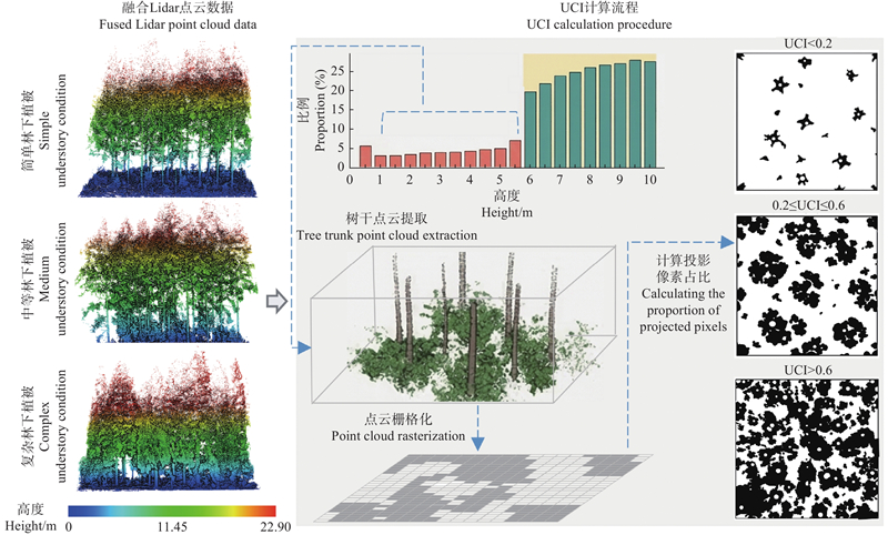
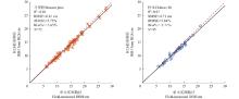
Fig.3
Relationships between handheld LiDAR-extracted DBH and field-measured DBH"
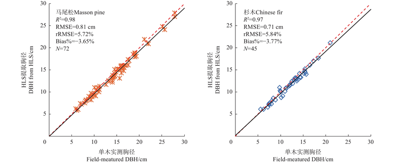
Fig.4
Comparison of tree heights from handheld and fused LiDAR data with field measurements based on felled trees"
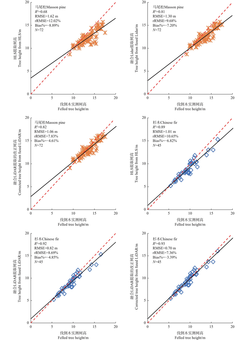
Fig.5
Comparison of single-tree volumes derived from DBH-based and DBH-height-based equations using felled tree measurements"
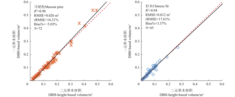
Table 2
Evaluation of tree volumes from HLS and fused LiDAR data using field measurements of felled trees m3"
| 参数 Parameters | 马尾松Masson pine | 杉木Chinese fir | |||
| RMSE (rRMSE) | Bias (Bias%) | RMSE (rRMSE) | Bias (Bias%) | ||
| 手持扫描数据提取的树高和胸径 Tree height and DBH extracted from HLS data | 0.027 (20.32%) | –0.019 (–15.01%) | 0.014 (21.48%) | –0.010 (–14.64%) | |
| 融合数据提取的树高和胸径 Tree height and DBH extracted from fused LiDAR data | 0.021 (16.11%) | –0.014 (–10.91%) | 0.015 (17.18%) | –0.006 (–9.25%) | |
| 手持扫描数据提取的胸径 DBH extracted from HLS data | 0.027 (20.40%) | –0.017 (–12.64%) | 0.014 (20.25%) | –0.004 (–6.25%) | |
Table 3
The results of individual tree segmentation"
| 林分类型 Forest types | 林下植被状况 Understory conditions | 样地个数 Number of Plots | 实际株数 Number of measured trees | 自动分割Automated segmentation | 手动分割Manual segmentation | |||||||
| 株数 No. of trees | R (%) | P (%) | F1 (%) | 株数 No. of trees | R (%) | P (%) | F1 (%) | |||||
| 马尾松 Masson pine | 简单 Simple | 2 | 189 | 192 | 98.41 | 96.88 | 97.64 | 187 | 98.94 | 100 | 99.47 | |
| 中等 Medium | 2 | 129 | 135 | 91.47 | 87.41 | 89.39 | 127 | 95.35 | 96.85 | 96.09 | ||
| 复杂 Complex | 2 | 169 | 212 | 88.76 | 70.75 | 78.74 | 175 | 94.67 | 91.43 | 93.02 | ||
| 杉木 Chinese fir | 简单 Simple | 3 | 143 | 147 | 97.9 | 95.24 | 96.55 | 146 | 99.3 | 97.26 | 98.27 | |
| 中等 Medium | 4 | 225 | 252 | 92.00 | 82.14 | 86.79 | 220 | 95.56 | 97.73 | 96.63 | ||
| 复杂 Complex | 3 | 198 | 296 | 90.40 | 60.47 | 72.47 | 197 | 94.95 | 95.43 | 95.19 | ||
| 阔叶 Broadleaf | 简单 Simple | 2 | 107 | 99 | 88.79 | 95.96 | 92.23 | 103 | 93.46 | 97.09 | 95.24 | |
| 中等 Medium | 2 | 156 | 138 | 79.49 | 89.86 | 84.35 | 168 | 92.95 | 86.31 | 89.51 | ||
| 复杂 Complex | 2 | 113 | 204 | 75.22 | 41.67 | 53.63 | 111 | 84.96 | 86.49 | 85.71 | ||
Table 4
The results of individual tree DBH extraction cm"
| 林下植被状况 Understory conditions | 马尾松Masson pine | 杉木Chinese fir | 阔叶Broadleaf | |||||
| RMSE (rRMSE) | Bias (Bias%) | RMSE (rRMSE) | Bias (Bias%) | RMSE (rRMSE) | Bias (Bias%) | |||
| 简单 Simple | 1.37 (8.78%) | –0.62 (–3.99%) | 1.31 (7.38%) | –0.76 (–4.28%) | 2.06 (12.48%) | –1.02 (–6.21%) | ||
| 中等 Medium | 2.06 (11.27%) | 0.37 (2.00%) | 1.38 (7.18%) | –0.59 (–3.0%) | 1.86 (21.75%) | –0.35 (–5.32%) | ||
| 复杂 Complex | 1.55 (8.24%) | –0.90 (–4.78%) | 1.35 (6.55%) | –0.51 (–2.49%) | 4.43 (27.12%) | 1.40 (8.59%) | ||
| 总体 Total | 1.63 (9.43%) | –0.44 (–2.54%) | 1.35 (7.05%) | –0.63 (–3.25%) | 3.15 (19.85%) | 0.18 (1.12%) | ||
Fig.6
Tree heights extracted from handheld laser scanning and fused LiDAR data for different forest types"
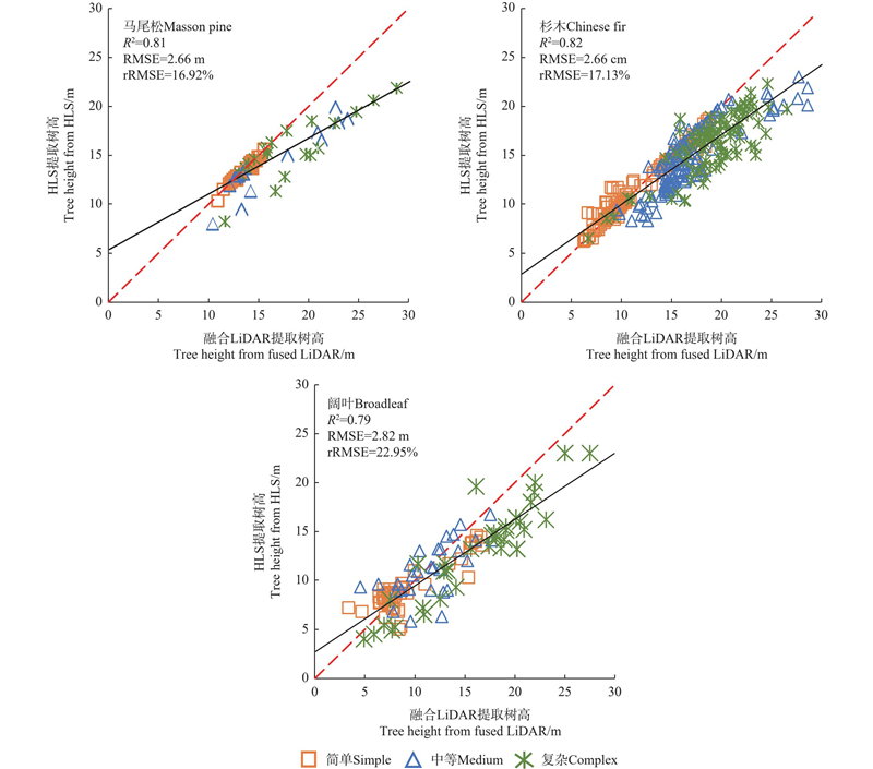
Table 5
Evaluation of single-tree heights from HLS data using the tree height from fused LiDAR data m"
| 林下植被状况 Understory conditions | 马尾松Masson pine | 杉木Chinese fir | 阔叶Broadleaf | |||||
| RMSE (rRMSE) | Bias (Bias%) | RMSE (rRMSE) | Bias (Bias%) | RMSE (rRMSE) | Bias (Bias%) | |||
| 简单 Simple | 0.21 (1.60%) | –0.13 (–0.96%) | 0.95 (8.32%) | –0.06 (–0.55%) | 1.77 (19.02%) | –0.10 (–1.10%) | ||
| 中等 Medium | 2.69 (17.03%) | –1.89 (–11.96%) | 2.83 (17.05%) | –2.07 (–12.50%) | 2.50 (21.59%) | –0.48 (–4.13%) | ||
| 复杂 Complex | 4.15 (21.92%) | –3.17 (–16.70%) | 3.65 (19.13%) | –2.96 (–15.54%) | 3.74 (23.64%) | –3.01 (–19.01%) | ||
| 总体 Total | 2.66 (16.92%) | –1.45 (–9.22%) | 2.66 (17.13%) | –1.64 (–10.54%) | 2.82 (22.95%) | –1.29 (–10.49%) | ||
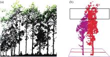
Fig.7
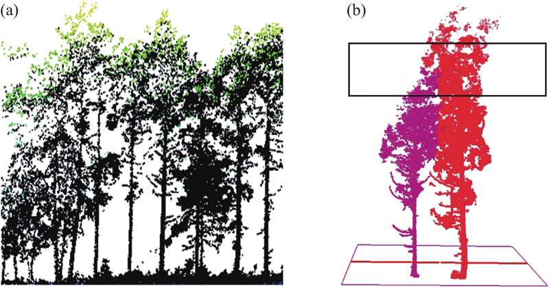
Two important factors affecting tree height extraction under complex forest structures a: Incomplete canopy point clouds of HLS data at tree top due to the occlusion under complex understory conditions (green dots: ALS point clouds; black dots: HLS point clouds); b: Mis-segmentation of single trees due to crown overlapping between two adjacent trees (different colors denote two segmented trees)"
|
邓云程, 王金亮, 刘钱威, 等. 提取林木胸径的F-LS算法. 遥感信息, 2022, 37 (5): 77- 84.
doi: 10.3969/j.issn.1000-3177.2022.05.012 |
|
|
Deng Y C, Wang J L, Liu Q W, et al. Tree DBH extraction based on F-LS algorithm. Remote Sensing Information, 2022, 37 (5): 77- 84.
doi: 10.3969/j.issn.1000-3177.2022.05.012 |
|
|
范光鹏, 许亮亮, 蔡会德, 等. 基于地基激光雷达点云的桉树单木参数提取与地上碳储量测定. 林业科学, 2026, 62 (3): 88- 99.
doi: 10.11707/j.1001-7488.LYKX20240701 |
|
|
Fan G P, Xu L L, Cai H D, et al. Extraction of individual Eucalyptus tree parameters and determination of aboveground carbon stock based on terrestrial LiDAR point clouds. Scientia Silvae Sinicae, 2026, 62 (3): 88- 99.
doi: 10.11707/j.1001-7488.LYKX20240701 |
|
| 国家林业局. 2014. 立木生物量模型及碳计量参数: 杉木(LY/T 2264—2014). 北京: 中国标准出版社. | |
| State Forestry Administration. 2014. Tree biomass models and related parameters to carbon accounting for Cunninghamia lanceolata (LY/T 2264—2014). Beijing: Standards Press of China. [in Chinese] | |
|
胡中洋, 陕 亮, 陈翔宇, 等. CHM与DSM相结合的无人机激光雷达单木分割. 林业科学, 2024, 60 (8): 14- 24.
doi: 10.11707/j.1001-7488.LYKX20230079 |
|
|
Hu Z Y, Shan L, Chen X Y, et al. Individual tree segmentation of UAV-LiDAR based on the combination of CHM and DSM. Scientia Silvae Sinicae, 2024, 60 (8): 14- 24.
doi: 10.11707/j.1001-7488.LYKX20230079 |
|
|
陆灯盛, 蒋先蝶, 李云鹤, 等. 基于激光雷达数据的森林生物量估测研究. 遥感学报, 2025, 29 (6): 2035- 2064.
doi: 10.11834/jrs.20255022 |
|
|
Lu D S, Jiang X D, Li Y H, et al. Forest biomass estimation with LiDAR data. National Remote Sensing Bulletin, 2025, 29 (6): 2035- 2064.
doi: 10.11834/jrs.20255022 |
|
| 王伟伟, 庞 勇, 杜黎明, 等. 超体素约简和谱聚类结合的机载LiDAR点云单木分割. 遥感学报, 2022, 26 (8): 1650- 1661. | |
| Wang W W, Pang Y, Du L M, et al. Individual tree segmentation for airborne LiDAR point cloud data using spectral clustering and supervoxel-based algorithm. Journal of Remote Sensing, 2022, 26 (8): 1650- 1661. | |
|
杨晨辉, 程寿民, 高谢雨, 等. 基于干形拟合的TLS长白落叶松树干参数提取. 林业科学, 2025, 61 (8): 154- 163.
doi: 10.11707/j.1001-7488.LYKX20240596 |
|
|
Yang C H, Cheng S M, Gao X Y, et al. Stem parameter estimation method for Larix olgensis based on TLS data of stem shape fitting. Scientia Silvae Sinicae, 2025, 61 (8): 154- 163.
doi: 10.11707/j.1001-7488.LYKX20240596 |
|
|
曾伟生. 杉木相容性立木材积表系列模型研建. 林业科学研究, 2014, 27 (1): 6- 10.
doi: 10.13275/j.cnki.lykxyj.2014.01.002 |
|
|
Zeng W S. Establishment of compatible tree volume equation system of Chinese fir. Forest Science Research, 2014, 27 (1): 6- 10.
doi: 10.13275/j.cnki.lykxyj.2014.01.002 |
|
|
Bauwens S, Bartholomeus H, Calders K, et al. Forest inventory with terrestrial LiDAR: A comparison of static and handheld mobile laser scanning. Forests, 2016, 7 (6): 127.
doi: 10.3390/f7060127 |
|
|
Brede B, Terryn L, Barbier N, et al. Non-destructive estimation of individual tree biomass: allometric models, terrestrial and UAV laser scanning. Remote Sensing of Environment, 2022, 280, 113180.
doi: 10.1016/j.rse.2022.113180 |
|
|
Cabo C, Del Pozo S, Rodríguez-Gonzálvez P, et al. Comparing terrestrial laser scanning (TLS) and wearable laser scanning (WLS) for individual tree modeling at plot level. Remote Sensing, 2018, 10 (4): 540.
doi: 10.3390/rs10040540 |
|
|
Dai W X, Yang B S, Liang X L, et al. Automated fusion of forest airborne and terrestrial point clouds through canopy density analysis. ISPRS Journal of Photogrammetry and Remote Sensing, 2019, 156, 94- 107.
doi: 10.1016/j.isprsjprs.2019.08.008 |
|
|
Dai W X, Kan H Y, Tan R C, et al. Multisource forest point cloud registration with semantic-guided keypoints and robust RANSAC mechanisms. International Journal of Applied Earth Observation and Geoinformation, 2022, 115, 103105.
doi: 10.1016/j.jag.2022.103105 |
|
|
de Conto T, Olofsson K, Görgens E B, et al. Performance of stem denoising and stem modelling algorithms on single tree point clouds from terrestrial laser scanning. Computers and Electronics in Agriculture, 2017, 143, 165- 176.
doi: 10.1016/j.compag.2017.10.019 |
|
|
Du L M, Pang Y, Wang Q, et al. A LiDAR biomass index-based approach for tree- and plot-level biomass mapping over forest farms using 3D point clouds. Remote Sensing of Environment, 2023, 290, 113543.
doi: 10.1016/j.rse.2023.113543 |
|
|
Duanmu J L, Xing Y Q. Annular neighboring points distribution analysis: a novel PLS stem point cloud preprocessing algorithm for DBH estimation. Remote Sensing, 2020, 12 (5): 808.
doi: 10.3390/rs12050808 |
|
|
Fekry R, Yao W, Cao L, et al. Ground-based/UAV-LiDAR data fusion for quantitative structure modeling and tree parameter retrieval in subtropical planted forest. Forest Ecosystems, 2022, 9, 100065.
doi: 10.1016/j.fecs.2022.100065 |
|
|
Hu Y, Xu X L, Wu F Y, et al. Estimating forest stocks volume in Hunan Province, China, by integrating in situ plot data, Sentinel-2 images, and linear and machine learning regression models. Remote Sensing, 2020, 12 (1): 186.
doi: 10.3390/rs12010186 |
|
|
Hyyppä E, Yu X W, Kaartinen H, et al. Comparison of backpack, handheld, under-canopy UAV, and above-canopy UAV laser scanning for field reference data collection in boreal forests. Remote Sensing, 2020, 12 (20): 3327.
doi: 10.3390/rs12203327 |
|
|
Jin S N, Zhang W M, Shao J, et al. Estimation of larch growth at the stem, crown, and branch levels using ground-based LiDAR point cloud. Journal of Remote Sensing, 2022, 2022, 9836979.
doi: 10.34133/2022/9836979 |
|
|
Jurjević L, Liang X, Gašparović M, et al. Is field-measured tree height as reliable as believed – Part Ⅱ. A comparison study of tree height estimates from conventional field measurement and low-cost close-range remote sensing in a deciduous forest. ISPRS Journal of Photogrammetry and Remote Sensing, 2020, 169, 227- 241.
doi: 10.1016/j.isprsjprs.2020.09.014 |
|
|
Li Y, Li G, Wang S, et al. Retrieval of Chinese fir tree parameters under different understory conditions with the integration of handheld and airborne LiDAR data. Geo-spatial Information Science, 2025, 28 (5): 2183- 2204.
doi: 10.1080/10095020.2024.2439399 |
|
|
Liang X L, Hyyppä J, Kaartinen H, et al. International benchmarking of terrestrial laser scanning approaches for forest inventories. ISPRS Journal of Photogrammetry and Remote Sensing, 2018, 144, 137- 179.
doi: 10.1016/j.isprsjprs.2018.06.021 |
|
|
Liang X L, Kankare V, Hyyppä J, et al. Terrestrial laser scanning in forest inventories. ISPRS Journal of Photogrammetry and Remote Sensing, 2016, 115, 63- 77.
doi: 10.1016/j.isprsjprs.2016.01.006 |
|
|
Liang X L, Wang Y S, Pyörälä J, et al. Forest in situ observations using unmanned aerial vehicle as an alternative of terrestrial measurements. Forest Ecosystems, 2019, 6 (1): 1- 16.
doi: 10.1186/s40663-019-0173-3 |
|
|
Liao K, Li Y H, Zou B Z, et al. Examining the role of UAV LidAR data in improving tree volume calculation accuracy. Remote Sensing, 2022, 14 (17): 4410.
doi: 10.3390/rs14174410 |
|
|
Lin W, Lu Y G, Li G Y, et al. A comparative analysis of modeling approaches and canopy height-based data sources for mapping forest growing stock volume in a northern subtropical ecosystem of China. GIScience & Remote Sensing, 2022, 59 (1): 568- 589.
doi: 10.1080/15481603.2022.2044139 |
|
|
Liu J C, Feng Z K, Mannan A, et al. Comparing non-destructive methods to estimate volume of three tree taxa in Beijing, China. Forests, 2019, 10 (2): 92.
doi: 10.3390/f10020092 |
|
|
Lu D S, Chen Q, Wang G X, et al. A survey of remote sensing-based aboveground biomass estimation methods in forest ecosystems. International Journal of Digital Earth, 2016, 9 (1): 63- 105.
doi: 10.1080/17538947.2014.990526 |
|
|
Lu D S, Jiang X D. A brief overview and perspective of using airborne LiDAR data for forest biomass estimation. International Journal of Image and Data Fusion, 2024, 15 (1): 1- 24.
doi: 10.1080/19479832.2024.2309615 |
|
|
Moe K, Owari T, Furuya N, et al. Comparing individual tree height information derived from field surveys, LiDAR and UAV-DAP for high-value timber species in Northern Japan. Forests, 2020, 11 (2): 223.
doi: 10.3390/f11020223 |
|
|
Oveland I, Hauglin M, Giannetti F, et al. Comparing three different ground based laser scanning methods for tree stem detection. Remote Sensing, 2018, 10 (4): 538.
doi: 10.3390/rs10040538 |
|
|
Qi Y, Coops N C, Daniels L D, et al. Comparing tree attributes derived from quantitative structure models based on drone and mobile laser scanning point clouds across varying canopy cover conditions. ISPRS Journal of Photogrammetry and Remote Sensing, 2022, 192, 49- 65.
doi: 10.1016/j.isprsjprs.2022.07.021 |
|
|
Seidel D, Annighöfer P, Ammer C, et al. Quantifying understory complexity in unmanaged forests using TLS and identifying some of its major drivers. Remote Sensing, 2021, 13 (8): 1513.
doi: 10.3390/rs13081513 |
|
|
Tao S L, Wu F F, Guo Q H, et al. Segmenting tree crowns from terrestrial and mobile LiDAR data by exploring ecological theories. ISPRS Journal of Photogrammetry and Remote Sensing, 2015, 110, 66- 76.
doi: 10.1016/j.isprsjprs.2015.10.007 |
|
|
Vorster A G, Evangelista P H, Stovall A E L, et al. Variability and uncertainty in forest biomass estimates from the tree to landscape scale: the role of allometric equations. Carbon Balance and Management, 2020, 15 (1): 8.
doi: 10.1186/s13021-020-00143-6 |
|
|
Wan P, Wang T J, Zhang W M, et al. Quantification of occlusions influencing the tree stem curve retrieving from single-scan terrestrial laser scanning data. Forest Ecosystems, 2019, 6 (1): 43.
doi: 10.1186/s40663-019-0203-1 |
|
|
Wang D, Liang X L, Mofack G I, et al. Individual tree extraction from terrestrial laser scanning data via graph pathing. Forest Ecosystems, 2021, 8, 1- 11.
doi: 10.1186/s40663-021-00340-w |
|
|
Wang Y S, Lehtomäki M, Liang X L, et al. Is field-measured tree height as reliable as believed: a comparison study of tree height estimates from field measurement, airborne laser scanning and terrestrial laser scanning in a boreal forest. ISPRS Journal of Photogrammetry and Remote Sensing, 2019, 147, 132- 145.
doi: 10.1016/j.isprsjprs.2018.11.008 |
|
|
Xie Y, Yang T, Wang X, et al. Applying a portable backpack LiDAR to measure and locate trees in a nature forest plot: Accuracy and error analyses. Remote Sensing, 2022, 14 (8): 1806.
doi: 10.3390/rs14081806 |
|
|
Yang J M, Yuan W W, Lu H C, et al. Assessing the performance of handheld laser scanning for individual tree mapping in an urban area. Forests, 2024, 15 (4): 575.
doi: 10.3390/f15040575 |
|
|
Zhao Y T, Im J, Zhen Z. Towards accurate individual tree parameters estimation in dense forest: optimized coarse-to-fine algorithms for registering UAV and terrestrial LiDAR data. GIScience & Remote Sensing, 2023, 60 (1): 2197281.
doi: 10.1080/15481603.2023.2197281 |
| Viewed | ||||||
|
Full text |
|
|||||
|
Abstract |
|
|||||