
Scientia Silvae Sinicae ›› 2024, Vol. 60 ›› Issue (11): 107-118.doi: 10.11707/j.1001-7488.LYKX20240134
Previous Articles Next Articles
Yongquan Ding1,2( ),Xiaoxiao Li1,Fengjun Zhao1,*,Liqing Si1,Lifu Shu1,Kaida Yan1,Jianhua Zhang3,Zhijie Peng3,Nuanyang Zhou1
Received:2024-03-08
Online:2024-11-25
Published:2024-11-30
Contact:
Fengjun Zhao
E-mail:953097190@qq.com
CLC Number:
Yongquan Ding,Xiaoxiao Li,Fengjun Zhao,Liqing Si,Lifu Shu,Kaida Yan,Jianhua Zhang,Zhijie Peng,Nuanyang Zhou. Forest Fire Risk Zoning of Artificial Forest Subcompartment in Saihanba Forest Farm Based on Fuel Characteristics[J]. Scientia Silvae Sinicae, 2024, 60(11): 107-118.
Table 1
Hierarchical structural model"
| A层目标层 Objective layer A | B层指标层 Indexes layer B | C层影响因子层 Influencing factors layer C |
| 森林火险等级 Forest fire risk classification | 土地类型Land type | 乔木林地、荒山、灌木林地、湿地、其他 Woodland, barren hill, shrubland, wetland, others |
| 可燃物特性Fuel characteristic | 优势树种、草本盖度、灌木盖度、枯落物厚度、郁闭度、修枝、蓄积量 Dominant tree species, herb layer coverage, shrub layer coverage, thickness of litter, canopy density, pruning, stand volume | |
| 地形Terrain | 海拔、坡向、坡度 Altitude, aspect, slope |
Table 2
Ignition risk Judgment matrix for each index of B layer"
| 指标Index | 土地类型 Land type | 可燃物特性 Fuel characteristic | 地形 Terrain |
| 土地类型 Land type | 1 | 1/5 | 2 |
| 可燃物特性 Fuel characteristic | 5 | 1 | 5 |
| 地形 Terrain | 1/2 | 1/5 | 1 |
Table 3
Ignition risk judgment matrix for land type influencing factors of C layer"
| 影响因子Influencing factors | 乔木林地Woodland | 灌木林地Shrubland | 荒山Barren hill | 湿地Wetland | 其他Others |
| 乔木林地Woodland | 1 | 1/2 | 1/3 | 3 | 5 |
| 灌木林地Shrubland | 2 | 1 | 3 | 5 | 5 |
| 荒山Barren hill | 3 | 1/3 | 1 | 5 | 7 |
| 湿地Wetland | 1/3 | 1/5 | 1/5 | 1 | 3 |
| 其他Others | 1/5 | 1/5 | 1/7 | 1/3 | 1 |
Table 4
Ignition risk judgment matrix for fuel characteristic influencing factors of C layer"
| 影响因子 Influencing factor | 优势树种 Dominant tree species | 草本盖度 Herb coverage | 灌木盖度 Shrub coverage | 枯落物厚度 Thickness of litter | 郁闭度 Canopy density | 修枝 Pruning | 蓄积量 Stand volume |
| 优势树种Dominant tree species | 1 | 2 | 2 | 3 | 2 | 7 | 9 |
| 草本盖度Herb coverage | 1/2 | 1 | 3 | 2 | 2 | 3 | 7 |
| 灌木盖度Shrub layer coverage | 1/2 | 1/3 | 1 | 2 | 2 | 3 | 7 |
| 枯落物厚度Thickness of litter | 1/3 | 1/2 | 1/2 | 1 | 2 | 4 | 5 |
| 郁闭度Canopy density | 1/2 | 1/2 | 1/2 | 1/2 | 1 | 3 | 5 |
| 修枝Pruning | 1/7 | 1/3 | 1/3 | 1/4 | 1/3 | 1 | 3 |
| 蓄积量Stand volume | 1/9 | 1/7 | 1/7 | 1/5 | 1/5 | 1/3 | 1 |
Table 5
Ignition risk judgment matrix for terrain influencing factors of C layer"
| 影响因子Influencing factor | 海拔Altitude | 坡向Aspect | 坡度Slope |
| 海拔Altitude | 1 | 1/2 | 3 |
| 坡向Aspect | 2 | 1 | 4 |
| 坡度Slope | 1/3 | 1/4 | 1 |
Table 6
Ignition risk weight values for the influencing factors of C layer to the objective A layer"
| B层指标 B layer indexes | C层影响因子 Influencing factors of C layer | 权重 Weight |
| 土地类型Land type | 乔木林地Woodland | 0.046 7 |
| 荒山Barren hill | 0.114 7 | |
| 灌木林地Shrubland | 0.082 8 | |
| 湿地Wetland | 0.020 5 | |
| 其他Others | 0.011 6 | |
| 可燃物特性 Fuel characteristic | 优势树种Dominant tree species | 0.181 6 |
| 草本盖度Herb layer coverage | 0.133 6 | |
| 灌木盖度Shrub layer coverage | 0.095 5 | |
| 枯落物厚度Thickness of litter | 0.077 5 | |
| 郁闭度Canopy density | 0.063 6 | |
| 修枝Pruning | 0.029 3 | |
| 蓄积量Stand volume | 0.014 3 | |
| 地形Terrain | 海拔Altitude | 0.041 0 |
| 坡向Aspect | 0.071 6 | |
| 坡度Slope | 0.015 6 |
Table 7
Ignition risk index values of C layer various influencing factors"
| C层影响因子 Iinfluencing factors of C layer | 阈值/类别 Threshold/category | 重要性赋值 Importance evaluation | 引燃危险 指数 Ignition risk index value | C层影响因子 Influencing factors ofC layer | 阈值/类别 Threshold/category | 重要性赋值 Importance evaluation | 引燃危险 指数 Ignition risk index value | |
| 优势树种 Dominant tree species | 易燃树种 Flammable tree species | 9 | 0.068 1 | 坡向Aspect | 南坡South | 9 | 0.025 8 | |
| 西南坡Southwest | 7 | 0.020 0 | ||||||
| 灌木林 Shrub | 7 | 0.053 0 | 东南坡Southeast | 7 | 0.020 0 | |||
| 西坡West | 7 | 0.020 0 | ||||||
| 可燃树种 Combustible species | 5 | 0.037 8 | 西北坡Northwest | 5 | 0.014 3 | |||
| 东北坡Northeast | 5 | 0.014 3 | ||||||
| 难燃树种 Flameresistant species | 3 | 0.022 7 | 无坡向 Non-slope direction | 5 | 0.014 3 | |||
| 东坡East | 3 | 0.008 6 | ||||||
| 北坡North | 1 | 0.002 9 | ||||||
| 郁闭度 Canopy density (%) | [0,0.2) | 9 | 0.022 9 | 坡度Slope(°) | ≥35 | 9 | 0.005 6 | |
| [0.2,0.4) | 7 | 0.017 8 | [25,35) | 7 | 0.004 4 | |||
| [0.4,0.6) | 5 | 0.012 7 | [15,25) | 5 | 0.003 1 | |||
| [0.6,0.8) | 3 | 0.007 6 | [5,15) | 3 | 0.001 9 | |||
| ≥0.8 | 1 | 0.002 5 | <5 | 1 | 0.000 6 | |||
| 灌木盖度 Shrub layer coverage (%) | >75 | 9 | 0.034 4 | 蓄积量 Stand volume/ (m3?hm?2) | ≥17.0 | 1 | 0.000 6 | |
| [51,75] | 7 | 0.026 7 | [10.0,17.0) | 3 | 0.001 7 | |||
| [26,50] | 5 | 0.019 1 | [5.0,10.0) | 5 | 0.002 9 | |||
| [5,25] | 3 | 0.011 5 | [2.0,5.0) | 7 | 0.004 0 | |||
| <5 | 1 | 0.003 8 | <2.0 | 9 | 0.005 1 | |||
| 草本盖度 Herb layer coverage (%) | >75 | 10 | 0.050 1 | 海拔 Altitude/m | < 120 0 | 9 | 0.014 8 | |
| [51,75] | 8 | 0.039 0 | [120 0,140 0) | 7 | 0.011 5 | |||
| [26,50] | 5 | 0.027 8 | [140 0,160 0) | 5 | 0.008 2 | |||
| [5,25] | 3 | 0.016 7 | [160 0,180 0) | 3 | 0.004 9 | |||
| <5 | 0 | 0.000 0 | ≥180 0 | 1 | 0.001 6 | |||
| 枯落物厚度 Thickness of litter/cm | ≥3 | 9 | 0.027 9 | 乔木林地Woodland | 0.050 2 | |||
| [2,3) | 7 | 0.021 7 | ||||||
| [1, 2) | 5 | 0.015 5 | 荒山 Barren hill | 0.123 3 | ||||
| [0.6, 1) | 3 | 0.009 3 | ||||||
| [0, 0.6) | 1 | 0.003 1 | 灌木林地Shrubland | 0.088 9 | ||||
| 修枝Pruning | 未修枝Unpruned | 7 | 0.020 5 | 湿地 Wetland | 0.022 1 | |||
| 修枝Pruned | 3 | 0.008 8 | 其他 Others | 0.012 5 |
Table 8
Fire intensity risk judgment matrix for each index of B layer"
| 指标Indexe | 土地类型 Land type | 可燃物特性 Fuel characteristic | 地形 Terrain |
| 土地类型Land type | 1 | 1/2 | 2 |
| 可燃物特性Fuel characteristic | 2 | 1 | 3 |
| 地形Terrain | 1/2 | 1/3 | 1 |
Table 9
Fire intensity risk judgment matrix for land type influencing factors of C layer"
| 影响因子Influencing factors | 乔木林地Woodland | 荒山Barren hill | 灌木林地Shrubland | 湿地Wetland | 其他Others |
| 乔木林地Woodland | 1 | 3 | 4 | 9 | 9 |
| 荒山Barren hill | 1/3 | 1 | 1/3 | 2 | 3 |
| 灌木林地Shrubland | 1/4 | 3 | 1 | 7 | 3 |
| 湿地Wetland | 1/9 | 1/2 | 1/7 | 1 | 3 |
| 其他Others | 1/9 | 1/3 | 1/3 | 1/3 | 1 |
Table 10
Fire intensity risk judgment matrix for fuel characteristic influencing factors of C layer"
| 影响因子Influencing factors | 优势 树种Dominant tree species | 修枝Pruning | 枯落物厚度Thickness of litter | 蓄积量Stand volume | 郁闭度Canopy density | 灌木盖度Shrub layer coverage | 草本盖度Herb layer coverage |
| 优势树种Dominant tree species | 1 | 2 | 3 | 3 | 3 | 6 | 7 |
| 修枝 Pruning | 1/2 | 1 | 2 | 2 | 2 | 5 | 7 |
| 枯落物 厚度Thickness of litter | 1/3 | 1/2 | 1 | 1/2 | 3 | 4 | 5 |
| 蓄积量 Stand volume | 1/3 | 1/2 | 2 | 1 | 1/2 | 3 | 4 |
| 郁闭度Canopy density | 1/3 | 1/2 | 1/3 | 2 | 1 | 2 | 5 |
| 灌木盖度Shrub layer coverage | 1/6 | 1/5 | 1/4 | 1/3 | 1/2 | 1 | 3 |
| 草本盖度Herb layer coverage | 1/7 | 1/7 | 1/5 | 1/4 | 1/5 | 1/3 | 1 |
Table 11
Fire intensity risk judgment matrix for terrain influencing factors of C layer"
| 影响因子Influencing factor | 坡度Slope | 坡向Aspect | 海拔Altitude |
| 坡度Slope | 1 | 2 | 3 |
| 坡向Aspect | 1/2 | 1 | 3 |
| 海拔Altitude | 1/3 | 1/3 | 1 |
Table 12
Fire intensity risk weight values for the influencing factors of C layer to objective A layer"
| B层指标 Indexes layer B | C层影响因子 Influencing factors of C layer | 权重 Weight |
| 土地类型Land type | 乔木林地Woodland | 0.156 4 |
| 荒山Barren hill | 0.035 2 | |
| 灌木林地Shrubland | 0.072 5 | |
| 湿地Wetland | 0.019 4 | |
| 其他Others | 0.013 5 | |
| 可燃物特性Fuel characteristic | 优势树种Dominant tree species | 0.173 3 |
| 草本盖度Herb layer coverage | 0.114 7 | |
| 灌木盖度Shrub layer coverage | 0.079 6 | |
| 枯落物厚度Thickness of litter | 0.068 5 | |
| 郁闭度Canopy density | 0.062 5 | |
| 修枝Pruning | 0.026 3 | |
| 蓄积量Stand volume | 0.014 7 | |
| 地形Terrain | 坡度Slope | 0.022 8 |
| 坡向Aspect | 0.054 3 | |
| 海拔Altitude | 0.086 3 |
Table 13
Fire intensity risk index values of C layer various influencing factors"
| C层影响因子 Influencing factors of C layer | 阈值/类别 Threshold/category | 重要性赋值 Importance evaluation | 火强度危险 指数Fire intensity risk index value | C层影响因子 Influencing factors of C layer | 阈值/类别 Threshold/category | 重要性赋值 Importance evaluation | 火强度危险 指数Fire intensity risk index value | |
| 优势树种 Dominant tree species | 粗脂肪含量≥5% Crude fat content≥5% | 9 | 0.062 4 | 坡向Aspect | 南坡South | 9 | 0.019 5 | |
| 粗脂肪含量[3.0%,5.0%) Crude fat content[3.0%,5.0%) | 7 | 0.048 5 | 西南坡Southwest | 7 | 0.015 2 | |||
| 粗脂肪含量[2.0%,3.0%) Crude fat content [2.0%,3.0%) | 5 | 0.034 7 | 东南坡Southeast | 7 | 0.015 2 | |||
| 粗脂肪含量[1.0%,2.0%) Crude fat content[1.0%,2.0%) | 3 | 0.020 8 | 西坡 West | 7 | 0.015 2 | |||
| 粗脂肪含量[0.0%,1.0%) Crude fat content [0.0%,1.0%) | 1 | 0.006 9 | 西北坡Northwest | 5 | 0.010 9 | |||
| 东北坡Northeast | 5 | 0.010 9 | ||||||
| 修枝Pruning | 未修枝Unpruned | 7 | 0.080 3 | 无坡向 Non-slope direction | 5 | 0.010 9 | ||
| 修枝Pruned | 3 | 0.034 4 | ||||||
| 东坡East | 3 | 0.006 5 | ||||||
| 郁闭度 Canopy density | [0,0.2) | 1 | 0.002 5 | 北坡North | 1 | 0.002 2 | ||
| [0.2,0.4) | 3 | 0.007 5 | ||||||
| [0.4,0.6) | 5 | 0.012 5 | 坡度Slope/(°) | ≥35 | 9 | 0.031 1 | ||
| [0.6,0.8) | 7 | 0.017 5 | [25,35) | 7 | 0.024 2 | |||
| ≥0.8 | 9 | 0.022 5 | [15,25) | 5 | 0.017 3 | |||
| [5,15) | 3 | 0.010 4 | ||||||
| 灌木盖度 Shrub layer coverage (%) | >75 | 9 | 0.022 4 | <5 | 1 | 0.003 5 | ||
| [51,75] | 7 | 0.017 4 | ||||||
| [26,50] | 5 | 0.012 5 | 蓄积量Stand volume/ (m3·hm?2) | ≥255.0 | 9 | 0.024 7 | ||
| [5,25] | 3 | 0.007 5 | [150.0,255.0) | 7 | 0.019 2 | |||
| <5 | 1 | 0.002 5 | [75.0,150.0) | 5 | 0.013 7 | |||
| [30.0,75.0) | 3 | 0.008 2 | ||||||
| 草本盖度 Herb layer coverage (%) | >75 | 10 | 0.005 3 | <30.0 | 1 | 0.002 7 | ||
| [51,75] | 8 | 0.004 1 | ||||||
| [26,50] | 5 | 0.002 9 | 海拔Altitude/m | < 120 0 | 9 | 0.008 2 | ||
| [5,25] | 3 | 0.001 8 | [120 0,140 0) | 7 | 0.006 4 | |||
| <5 | 1 | 0.000 6 | [140 0,160 0) | 5 | 0.004 6 | |||
| [160 0,180 0) | 3 | 0.002 7 | ||||||
| 枯落物厚度Thickness of litter/cm | ≥5.0 | 9 | 0.028 7 | ≥ 180 0 | 1 | 0.000 9 | ||
| [3.0,5.0) | 7 | 0.022 3 | ||||||
| [2.0,3.0) | 5 | 0.015 9 | 荒山 Barren hill | 0.035 2 | ||||
| [1.0-2.0) | 3 | 0.009 6 | 灌木林地Shurbland | 0.072 5 | ||||
| [0.0-1.0) | 1 | 0.003 2 | 湿地Wetland | 0.019 4 | ||||
| 乔木林地 Woodland | 0.156 4 | 其他 Others | 0.013 5 |
Table 14
Forest fire risk classification for Saihanba Mechanized Forest Farm"
| 火灾风险类型 Fire risk type | 火险等级 Fire risk classification | 危险程度 Risk level | 危险指数 Risk index value | 小班面积占比 Area proportion of subcompartment (%) |
| 引燃危险 Ignition risk | ⅤY | 极高Extremely high | 0.256 3?0.329 0 | 9.21 |
| ⅣY | 高High | 0.218 5?0.256 2 | 26.25 | |
| ⅢY | 较高Relatively high | 0.185 4?0.218 4 | 32.49 | |
| ⅡY | 较低Relatively low | 0.146 2?0.185 3 | 24.03 | |
| Ⅰy | 低Low | 0.095 7?0.146 1 | 8.02 | |
| 火强度危险 Fire intensity risk | ⅤQ | 极高Extremely high | 0.365 0?0.430 0 | 46.42 |
| ⅣQ | 高High | 0.297 4?0.364 9 | 26.38 | |
| ⅢQ | 较高Relatively high | 0.211 5?0.297 3 | 7.95 | |
| ⅡQ | 较低Relatively low | 0.159 3?0.211 4 | 7.93 | |
| ⅠQ | 低Low | 0.089 3?0.159 2 | 11.33 | |
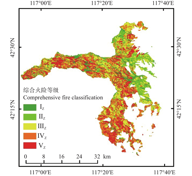
| 综合火险 Comprehensive fire risk | ⅤZ | 极高Extremely high | 0.271 2?0.323 7 | 19.13 |
| ⅣZ | 高High | 0.248 2- 0.271 1 | 29.07 | |
| ⅢZ | 较高Relatively high | 0.222 3?0.248 1 | 28.12 | |
| ⅡZ | 较低Relatively low | 0.174 9?0.222 2 | 12.42 | |
| ⅠZ | 低Low | 0.102 6?0.174 8 | 11.26 |

Fig.1
Frequency distribution of ignition risk index values"
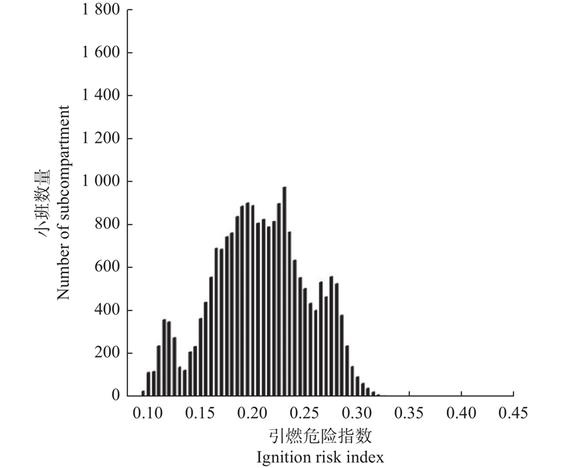

Fig.2
Ignition risk classification map of the Saihanba Mechanized Forest Farm"
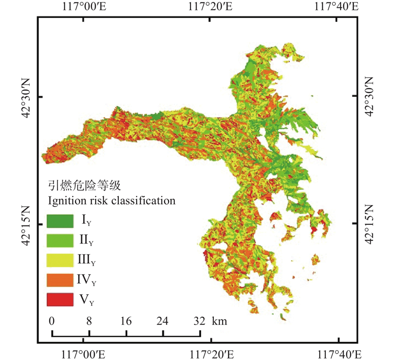

Fig.3
Frequency distribution of fire intensity risk index values"
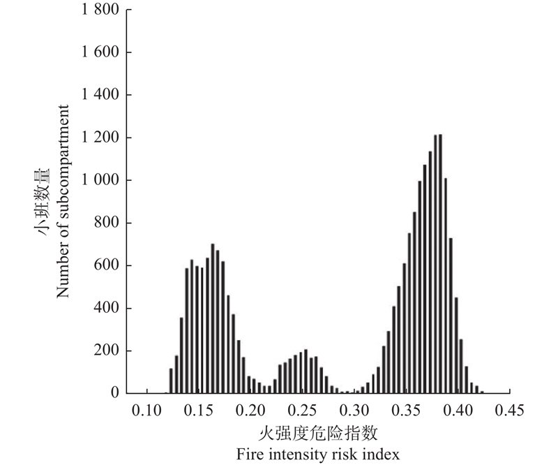

Fig.4
Fire intensity risk classification map of the Saihanba Mechanized Forest Farm"
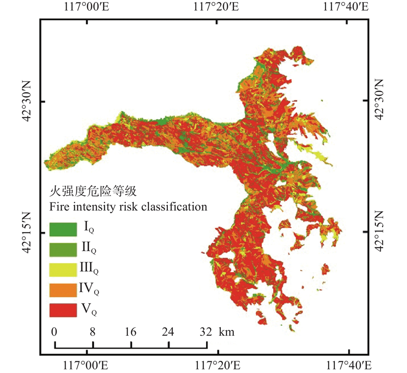

Fig.5
Frequency distribution of comprehensive risk index values"
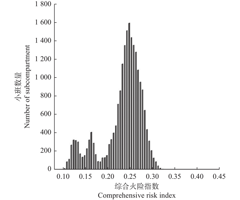

Fig.6
Comprehensive fire risk classification map of the Saihanba Mechanized Forest Farm"
|
程 顺, 王 超, 刘艳庄. 塞罕坝林区地表可燃物研究. 河北林果研究, 2011, 26 (1): 34- 37.
doi: 10.3969/j.issn.1007-4961.2011.01.011 |
|
|
Cheng S, Wang C, Liu Y Z. Research of the surface combustible substance in Saihanba. Hebei Journal of Forestry and Orchard Research, 2011, 26 (1): 34- 37.
doi: 10.3969/j.issn.1007-4961.2011.01.011 |
|
| 邸雪颖, 楚 旭, 杨 光, 等. 我国2000—2012年夏季森林火灾分布规律. 世界林业研究, 2015, 28 (4): 72- 75. | |
| Di X Y, Chu X, Yang G et al. Distribution of summer forest fires in China in 2000—2012. World Forestry Research, 2015, 28 (4): 72- 75. | |
| 丁永全, 舒立福, 吴 松, 等. 塞罕坝林场不同林型地表枯落物特性及对应火险特征研究. 西南林业大学学报(自然科学), 2021, 41 (4): 111- 118. | |
| Ding Y Q, Shu L F, Wu S, et al. Characteristics of litter and corresponding fire risk of different forest types in Saihanba Forestry Center. Journal of Southwest Forestry University(Natural Science), 2021, 41 (4): 111- 118. | |
|
段建国, 李欣泽, 吴 兵, 等. 基于Landsat 8的泰山森林火险区划等级研究. 传感器世界, 2020, 26 (10): 17- 21.
doi: 10.3969/j.issn.1006-883X.2020.10.003 |
|
|
Duan J G, Li X Z, Wu B, et al. Study on forest fire risk regionalization in Tai Shan Mountain based on Landsat 8. Sensor World, 2020, 26 (10): 17- 21.
doi: 10.3969/j.issn.1006-883X.2020.10.003 |
|
|
高 敏, 任云卯, 周晓东, 等. 抚育间伐对西山林场侧柏林冠层可燃物特征及潜在火行为的影响. 北京林业大学学报, 2022, 44 (8): 56- 65.
doi: 10.12171/j.1000-1522.20210455 |
|
|
Gao M, Ren Y M, Zhou X D, et al. Effects of thinning on canopy characteristics and potential crown fire behavior of Platycladus orientalis in Xishan Forest Farm of Beijing. Journal of Beijing Forestry University, 2022, 44 (8): 56- 65.
doi: 10.12171/j.1000-1522.20210455 |
|
|
宫大鹏, 曹 萌, 闫 淳, 等. 我国祭祀火灾时空分布特征分析. 森林防火, 2023, 41 (4): 68- 71.
doi: 10.3969/j.issn.1002-2511.2023.04.016 |
|
|
Gong D P, Cao M, Yan C et al. Analysis on the temporal and spatial distribution characteristics of sacrificial fire in China. Journal of Wildland Fire Science, 2023, 41 (4): 68- 71.
doi: 10.3969/j.issn.1002-2511.2023.04.016 |
|
|
黄宝华, 张 华, 孙治军. 基于层次分析(AHP)的山东森林火风险区划研究. 火灾科学, 2014, 23 (4): 225- 232.
doi: 10.3969/j.issn.1004-5309.2014.04.06 |
|
|
Huang B H, Zhang H, Sun Z J. Shandong forest fire danger division research based on analytic hierarchy prosess(AHP). Fire Safe Science, 2014, 23 (4): 225- 232.
doi: 10.3969/j.issn.1004-5309.2014.04.06 |
|
| 李 婧. 2022. 内蒙古大兴安岭林火时空分布及火险区划. 呼和浩特: 内蒙古农业大学. | |
| Li J. 2022. Spatial-temporal distribution and fire danger area division of forest fire in Inner Mongolia Great Khingan. Hohhot: Inner Mongolia Agricultural University. [in Chinese] | |
| 李伟克, 张 晨, 谷兴翰, 等. 2020. 北京西山侧柏林可燃物调控措施的影响评价. 浙江农林大学学报, 37(3): 472−479. | |
| Li W K, Zhang C, Gu X H, et al. 2020. Impact assessment of fuel regulation measures in Platycladus orientalis forest in Western Hills of Beijing. Journal of Zhejiang A&F University, 37(3): 472−479. [in Chinese] | |
| 李艳琴, 胡海清. 森林可燃物抽提物研究综述. 世界林业研究, 2008, 21 (6): 54- 56. | |
| Li Y Q, Hu H Q. Summary of research on forest combustible extraction. World Forestry Research, 2008, 21 (6): 54- 56. | |
|
苗庆林, 田晓瑞, 陈立光. 基于层次分析法的森林火险区划——以徂徕山林场为例. 火灾科学, 2013, 22 (3): 113- 119.
doi: 10.3969/j.issn.1004-5309.2013.03.01 |
|
|
Miao Q L, Tian X R , Chen L G , et al. Forest fire risk zoning based on analytic hierarchy process: a case study for Culai mountain forest center. Fire Safe Science, 2013, 22 (3): 113- 119.
doi: 10.3969/j.issn.1004-5309.2013.03.01 |
|
| 牛树奎, 王 叁, 贺庆棠, 等. 北京山区主要针叶林可燃物空间连续性研究——可燃物垂直连续性与树冠火发生. 北京林业大学学报, 2012, 34 (3): 1- 7. | |
| Niu S K, Wang S, He Q T, et al. Spatial continuity of fuels in major coniferous forests in Beijing mountainous area: fuel vertical continuity and crown fire occurrence. Journal of Beijing Forestry University, 2012, 34 (3): 1- 7. | |
| 努尔古丽·马坎, 张毓涛, 岳朝阳, 等. 天山中部9种乔灌木可燃物含水率及脂肪含量分析. 安徽农业大学学报, 2012, 39 (6): 925- 929. | |
| Makan N, Zhang Y T, Yue Z Y, et al. Analysis of the water content and fuel moisture content of forest combustible in the center of Tianshan Mountains. Journal of Anhui Agricultural University, 2012, 39 (6): 925- 929. | |
| 秦乃花, 陈 瑞, 吕常笑, 等. 山东省不同林分地表可燃物载量及其燃烧性研究. 西北林学院学, 2023, 38 (5): 176- 183. | |
| Qin N H, Chen R, Lü C X, et al. Surface fuel loading and combustion characteristics of different forest types in Shandong Province. Journal of Northwest Forestry University, 2023, 38 (5): 176- 183. | |
| 舒立福, 刘晓东. 2016. 森林防火学概论. 北京: 中国林业出版社. | |
| Shu L F, Liu X D. 2016. Introduction to forest fire prevention. Beijing: China Forestry Publishing House. [in Chinese] | |
|
孙 武, 牛树奎, 赵 蓓, 等. 大岗山地区主要林型可燃物调查与林火行为. 江西农业大学学报, 2012, 34 (6): 1171- 1179.
doi: 10.3969/j.issn.1000-2286.2012.06.016 |
|
|
Sun W, Niu S K, Zhao B, et al. Forest fuel survey and fire behavior in main forests in Dagangshan. Acta Agriculturae Universitatis Jiangxiensis, 2012, 34 (6): 1171- 1179.
doi: 10.3969/j.issn.1000-2286.2012.06.016 |
|
|
田光辉, 陈汇林, 许向春. 基于模糊综合判别的森林火险等级预报研究. 灾害学, 2013, 28 (3): 117- 122.
doi: 10.3969/j.issn.1000-811X.2013.03.022 |
|
|
Tian G H, Chen H L, Xu X C. Study on grade prediction on forest fire based on fussy synthetic discrimimant. Journal of Catastrophology, 2013, 28 (3): 117- 122.
doi: 10.3969/j.issn.1000-811X.2013.03.022 |
|
| 王晓红, 阳丽虹, 马明浩, 等. 塞罕坝机械林场生态环境质量评价. 华北理工大学学报(自然科学版), 2023, 45 (3): 11- 18. | |
| Wang X H, Yang L H, Ma M H, et al. Ecological environment quality evaluation of Saihanba forest farm. Journal of North China University of Science and Technology(Natural Science Edition), 2023, 45 (3): 11- 18. | |
|
王忆文, 索奥丽, 高 钰. 四川西昌云南松林地表可燃物载量及影响因素研究. 北京林业大学学报, 2023, 45 (1): 100- 108.
doi: 10.12171/j.1000-1522.20220398 |
|
|
Wang Y W, Suo A L, Gao J. Surface fuel load and influencing factors of Pinus yunnanensis forest in Xichang City, Sichuan Province of southwestern China. Journal of Beijing Forestry University, 2023, 45 (1): 100- 108.
doi: 10.12171/j.1000-1522.20220398 |
|
|
魏建珩, 赵 恒, 高仲亮, 等. 毛乌素沙地主要树种燃烧性研究. 消防科学与技术, 2021, 40 (11): 1676- 1681.
doi: 10.3969/j.issn.1009-0029.2021.11.026 |
|
|
Wei J H, Zhao H, Gao Z L, et al. Study on the combustibility of main tree species in Mu Us Sandy Land. Fire Science and Technology, 2021, 40 (11): 1676- 1681.
doi: 10.3969/j.issn.1009-0029.2021.11.026 |
|
|
魏书精, 罗斯生, 罗碧珍, 等. 气候变化背景下森林火灾发生规律研究. 林业与环境科学, 2020, 36 (2): 133- 143.
doi: 10.3969/j.issn.1006-4427.2020.02.019 |
|
|
Wei S J, Luo S S, Luo B Z, et al. Occurrence regularity of forest fire under the background of climate change. Forestry and Environmental Science, 2020, 36 (2): 133- 143.
doi: 10.3969/j.issn.1006-4427.2020.02.019 |
|
|
张 恒, 敖子奇, 乌日汉, 等. 内蒙古大兴安岭主要乔灌树种理化性质及抗火性研究. 西南林业大学学报, 2020, 40 (4): 61- 67.
doi: 10.11929/j.swfu.201909045 |
|
|
Zhang H, Ao Z Q, Wu R H, et al. Study on physicochemical properties and fire-resistance of main tree and shrub species in Daxing’an Mountains, Inner Mongolia. Journal of Southwest Forestry University, 2020, 40 (4): 61- 67.
doi: 10.11929/j.swfu.201909045 |
|
|
张文文, 闫想想, 王秋华, 等. 计划烧除对云南松林地表可燃物火行为的影响. 北京林业大学学报, 2022, 44 (5): 69- 76.
doi: 10.12171/j.1000-1522.20200328 |
|
|
Zhang W W, Yan X X, Wang Q H et al. Effects of prescribed burning on fire behavior of surface fuel in Pinus yunnanensis forest land. Journal of Beijing Forestry University, 2022, 44 (5): 69- 76.
doi: 10.12171/j.1000-1522.20200328 |
|
| 张玉春, 向 东, 郭瀚文, 等. 川西南森林可燃物分布调研及潜在火行为研究. 自然灾害学报, 2023, 32 (2): 108- 116. | |
| Zhang Y C, Xiang D, Guo H W, et al. Reaserch on the distribution of combustible materials and potential fire behavior in southwest Sichuan forests. Journal of Natural Disasters, 2023, 32 (2): 108- 116. | |
| 张运生, 舒立福, 赵凤君, 等. 基于云南松林计划烧除的可燃物调控效果评价研究. 西北林学院学报, 2023, 38 (4): 189- 196. | |
| Zhang Y S, Shu L F, Zhao F J, et al. Evaluation of fuel treatments based on prescribed burning in Pinus yunnanensis forest. Journal of Northwest Forestry University, 2023, 38 (4): 189- 196. | |
| 赵鹏武, 武峻毅, 张 恒. 基于聚类分析法的我国森林火险等级区划研究. 林业工程学报, 2021, 6 (3): 142- 148. | |
| Zhao P W, Wu J Y, Zhang H. Study on forest fire risk classification in China using cluster analysis. Journal of Forestry Engineering, 2021, 6 (3): 142- 148. | |
| Akay A E, Erdoğan A. 2017. GIS-based multi-criteria decision analysis for forest fire risk mapping. ISPRS Annals of the Photogrammetry, Remote Sensing and Spatial Information Sciences, Ⅳ-4/W4, 25−30. | |
|
Çoban H O, Erdin C. Forest fire risk assessment using GIS and AHP integration in bucak forest enterprise, Turkey. Applied Ecology and Environmental Research, 2020, 18 (1): 1567- 1583.
doi: 10.15666/aeer/1801_15671583 |
|
|
Jia X, Gao Y, Wei B C, et al. Risk assessment and regionalization of rire disaster based on analytic hierarchy process and MODIS data: a case study of Inner Mongolia, China. Sustainability, 2019, 11 (22): 6263.
doi: 10.3390/su11226263 |
|
|
Kant Sharma L, Kanga S, Singh Nathawat M, et al. Fuzzy AHP for forest fire risk modeling. Disaster Prevention and Management, 2012, 21 (2): 160- 171.
doi: 10.1108/09653561211219964 |
|
|
Kumar D, Garg C P. Evaluating sustainable supply Chain indicators using fuzzy AHP: case of Indian automotive industry. Benchmarking; An International Journal, 2017, 24 (6): 1742- 1766.
doi: 10.1108/BIJ-11-2015-0111 |
|
|
Kumari B, Pandey A C. Geo-informatics based multi-criteria decision analysis (MCDA) through analytic hierarchy process (AHP) for forest fire risk mapping in Palamau Tiger Reserve, Jharkhand state, India. Journal of Earth System Science, 2020, 129, 204.
doi: 10.1007/s12040-020-01461-6 |
|
|
Lamat R, Kumar M, Kundu A, et al. Forest fire risk mapping using analytical hierarchy process (AHP) and earth observation datasets: a case study in the mountainous terrain of Northeast India. SN Applied Sciences, 2021, 3, 425.
doi: 10.1007/s42452-021-04391-0 |
|
|
Mehta D, Baweja P K, Aggarwal R K. Forest fire risk assessment using fuzzy analytic hierarchy process. Current World Environment, 2018, 13 (3): 307- 316.
doi: 10.12944/CWE.13.3.05 |
|
|
Pradeep G S, Patel N, Kuriakose S L, et al. Forest fire risk zone mapping of Eravikulam national park in India: a comparison between frequency ratio and analytic hierarchy process methods. Croatian Journal of Forest Engineering, 2022, 43 (1): 199- 217.
doi: 10.5552/crojfe.2022.1137 |
|
|
Sivrikaya F, Küçük Ö. Modeling forest fire risk based on GIS-based analytical hierarchy process and statistical analysis in Mediterranean region. Ecological Informatics, 2022, 68, 101537.
doi: 10.1016/j.ecoinf.2021.101537 |
| [1] | Zhihan Yu,Hongqiang Yang. Research Frontier and Prospect of Forest Management Decision-Making Methodology Based on Generalized Faustmann Model [J]. Scientia Silvae Sinicae, 2024, 60(9): 170-182. |
| [2] | Mengxing Li,Ziwei Wang,Kuibin Zhou. Modeling the Threats of Forest Fires to the Buildings in the Wildland-Urban Interface [J]. Scientia Silvae Sinicae, 2024, 60(11): 119-127. |
| [3] | Bingchen Wu,Shi Qi,Zhengxi Guo,Yishui Hu. Attribution of Superficial Landslide Risk of Forestland in Huaying Mountains Based on MaxEnt Model [J]. Scientia Silvae Sinicae, 2024, 60(1): 32-46. |
| [4] | Bo Wang,Xueqing Yang,Chunying Jiang,Dong Liu,Feng Chen,Ye Bai,Xiaodong Liu. Forest Fire Spread Risk in Yanqing District of Beijing Based on GIS [J]. Scientia Silvae Sinicae, 2023, 59(8): 90-101. |
| [5] | Xiaorui Tian,Xuezheng Zong,Mingyu Wang. A Review of Recent Progress in Fire Management of Wildland-Urban Interface [J]. Scientia Silvae Sinicae, 2023, 59(6): 149-158. |
| [6] | Pingping Li,Yanhui Wang,Wenbiao Duan,Yirui Wang,Pengtao Yu,Li Zhen,Zhixin Li,Huijun Shang,Zaijun Shi,Yipeng Yu. Variation and Evaluation of Site Index of Black Locust Plantations on the Loess Plateau of Northwest China [J]. Scientia Silvae Sinicae, 2023, 59(4): 18-31. |
| [7] | Fuwei Wang,Minghua Tian,Shaozhi Chen,Hongxun Li,Mingxing Hu. Multidimensional Analysis and Evaluation of China’s Wood Pulp Import Risk [J]. Scientia Silvae Sinicae, 2023, 59(10): 150-161. |
| [8] | Feng Lu,Guangtong Gu,Xianlei Cao,Weiguang Wu. Risk of Forestry Carbon Sink Project Based on Coupling Effect [J]. Scientia Silvae Sinicae, 2022, 58(5): 161-176. |
| [9] | Xingxia Ma,Jiaxin Li,Lin Wang,Yanhua Wang. Damage of Coleoptera Longhorned Beetles in Wooden Components of Ancient Buildings in China [J]. Scientia Silvae Sinicae, 2022, 58(12): 130-140. |
| [10] | Rui Bai,Ning Li,Shaojun Liu,Xiaomin Chen,Haiping Zou,Run Lü. Risk Analysis of White Root Disease on Rubber Trees in China under the Background of Future Climate Change [J]. Scientia Silvae Sinicae, 2021, 57(6): 37-45. |
| [11] | Xingxia Ma,Lin Wang,Haiyan Zhu,Bo Liu,Bin Zhang,Yun Lu,Yanhua Wang,Mingliang Jiang,Liuru Wang. Risk Zones of Carpenter Bees for Wooden Structure of Ancient Buildings in China [J]. Scientia Silvae Sinicae, 2021, 57(4): 116-123. |
| [12] | Long Sun,Qi Liu,Tongxin Hu. Advances in Research on Prediction Model of Moisture Content of Surface Dead Fuel in Forests [J]. Scientia Silvae Sinicae, 2021, 57(4): 142-152. |
| [13] | Jiangxia Ye,Jingwen Wang,Mingsha Zhang,Ruliang Zhou,Lei Shi. Risk Pattern Analysis of Hyphantria cunea Based on Spatial Matrix Model and 0-1 Measure [J]. Scientia Silvae Sinicae, 2021, 57(1): 140-152. |
| [14] | Siqi Sun,Yuetai Weng,Xueying Di,Zhihua Liu,Guang Yang. Screening of Efficient Cellulose-Degrading Fungi and Their Effects on Degradation of Forest Surface Fuel [J]. Scientia Silvae Sinicae, 2020, 56(8): 89-97. |
| [15] | Heng Zhang,Yaxing Zhen,Jiayan Li,Jiang Xue,Qiuliang Zhang. Pyrolysis Characteristics of Typical Tree and Shrub Species and Their Surface Dead Fuel in Daxing'an Mountains of Inner Mongolia [J]. Scientia Silvae Sinicae, 2020, 56(7): 104-114. |
| Viewed | ||||||
|
Full text |
|
|||||
|
Abstract |
|
|||||