
林业科学 ›› 2021, Vol. 57 ›› Issue (10): 23-35.doi: 10.11707/j.1001-7488.20211003
李春干1,李振2
收稿日期:2020-08-17
出版日期:2021-10-25
发布日期:2021-12-11
基金资助:Chungan Li1,Zhen Li2
Received:2020-08-17
Online:2021-10-25
Published:2021-12-11
摘要:
目的: 针对当前森林参数估测模型受研究区条件、森林类型限制不具备普适性的问题,从森林三维结构分析描述出发,构建森林参数估测多元乘幂模型式,并测试其在不同森林类型不同森林参数估测中的表现,检验其推广能力,以期发现一个适用于不同森林类型不同森林参数估测的模型结构式,为激光雷达森林参数的一致性估测提供实践案例。方法: 以面积2.21万km2的南亚热带丘陵山地区域为研究区,以面积法为基础,将刻画森林冠层三维结构的7个离散回波LiDAR变量进行组合,构建5个森林参数估测多元乘幂模型式,通过383块样地测试5个模型式在不同森林类型(杉木林、松树林、桉树林和阔叶林)不同森林参数(蓄积量、断面积和平均直径)估测中的表现。结果: 以激光雷达点云平均高、冠层覆盖度、叶面积密度变动系数、激光雷达点云高度变动系数、50%分位数密度为变量的模型结构式表现最好;4种森林类型蓄积量估测模型的决定系数(R2)分别为0.667、0.769、0.764和0.602,相对均方根误差(rRMSE)变化范围为18.53%~36.32%,平均预估误差(MPE)变化范围为3.37%~6.95%;4种森林类型断面积估测模型的R2分别为0.572、0.582、0.706和0.568,rRMSE变化范围为16.11%~30.82%,MPE变化范围为3.27%~5.89%;4种森林类型平均直径估测模型的R2分别为0.574、0.501、0.709和0.240,rRMSE变化范围为10.07%~29.01%,MPE变化范围为1.83%~5.55%;最优普适性模型式的R2与各森林类型各森林参数最优模型的R2的相差小于5%,rRMSE和MPE的相差均小于7%。结论: 本研究提出的模型式变量具有明确的生物物理意义和林学解析意义,可准确刻画林分冠层三维结构,在不同森林类型不同森林参数估测中均取得较好效果,具有良好的普适性,有利于提高不同森林类型估测结果的可比性,可用于机载激光雷达大区域森林资源动态监测。
中图分类号:
李春干,李振. 机载激光雷达大区域亚热带森林参数估测的普适性模型式[J]. 林业科学, 2021, 57(10): 23-35.
Chungan Li,Zhen Li. Generalizing Predictive Models of Sub-Tropical Forest Inventory Attributes Using an Area-Based Approach with Airborne LiDAR Data[J]. Scientia Silvae Sinicae, 2021, 57(10): 23-35.
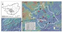
图1
研究区及样地分布"

表1
样地森林参数的统计特征"
| 森林类型 Forest type | 样地数量 Sample size | 森林参数 Forest attribute | 均值 Mean | 最小值 Min. | 最大值 Max. | 标准差 St.dev. | 变动系数 CV(%) |
| 杉木林 Chinese fir | 84 | 林分年龄Age/a | 16.9 | 5.0 | 34.0 | 5.5 | 32.4 |
| 直径DBH/cm | 11.7 | 5.0 | 21.2 | 3.7 | 31.1 | ||
| 树高Height/m | 10.5 | 5.7 | 18.0 | 2.8 | 27.0 | ||
| 断面积Basal area(BA)/(m2·hm-2) | 30.2 | 12.8 | 48.6 | 7.5 | 24.9 | ||
| 蓄积量Stand volume(VOL)/(m3·hm-2) | 173.7 | 49.3 | 334.4 | 62.8 | 36.2 | ||
| 松树林 Masson pine | 97 | 林分年龄Age/a | 28.8 | 8.0 | 48.0 | 7.6 | 26.4 |
| 直径DBH/cm | 19.0 | 4.7 | 34.4 | 5.3 | 27.7 | ||
| 树高Height/m | 13.0 | 4.0 | 26.0 | 3.5 | 26.6 | ||
| 断面积Basal area(BA)/(m2·hm-2) | 26.7 | 5.0 | 53.5 | 8.5 | 32.0 | ||
| 蓄积量Stand volume(VOL)/(m3·hm-2) | 173.7 | 16.9 | 588.4 | 83.0 | 47.8 | ||
| 桉树林 Eucalyptus | 107 | 林分年龄Age/a | 4.5 | 2.0 | 9.0 | 1.5 | 34.3 |
| 直径DBH/cm | 11.4 | 2.0 | 18.0 | 2.2 | 19.4 | ||
| 树高Height/m | 16.3 | 9.8 | 25.1 | 2.7 | 16.6 | ||
| 断面积Basal area(BA)/(m2·hm-2) | 18.3 | 5.1 | 33.9 | 5.7 | 30.9 | ||
| 蓄积量Stand volume(VOL)/(m3·hm-2) | 150.1 | 31.8 | 266.8 | 58.1 | 38.7 | ||
| 阔叶林 Broadleaf | 95 | 林分年龄Age/a | 24.4 | 5.0 | 60.0 | 10.5 | 43.0 |
| 直径DBH/cm | 13.6 | 5.0 | 37.1 | 5.5 | 40.3 | ||
| 树高Height/m | 9.5 | 5.0 | 17.4 | 2.5 | 26.6 | ||
| 断面积Basal area(BA)/(m2·hm-2) | 17.6 | 1.6 | 44.3 | 8.6 | 48.7 | ||
| 蓄积量Stand volume(VOL)/(m3·hm-2) | 91.8 | 9.5 | 326.3 | 59.6 | 64.9 |
表2
各森林类型各森林参数最优模型和次优模型的拟合效果"
| 森林类型 Forest type | 森林参数 Forest attribute | 模型编号 No. of model | 参数估计值Parameter estimates | R2 | rRMSE(%) | MPE(%) | |||||||
| a0 | Hmean | CC | LADcv | Hstdev | Hcv | dh50 | dh75 | ||||||
| 杉木林 Chinese fir | VOL | (8) | 9.826 6 | 1.413 0 | 0.771 0 | 0.158 3 | -0.387 8 | -0.033 3 | 0.726 | 18.80 | 4.21 | ||
| (9) | 9.230 5 | 1.036 3 | 0.802 9 | 0.117 9 | -0.441 0 | -0.174 0 | 0.733 | 18.57 | 4.16 | ||||
| BA | (8) | 3.863 4 | 1.079 6 | 0.383 5 | 0.008 0 | -0.576 8 | -0.074 2 | 0.570 | 16.25 | 3.64 | |||
| (9) | 3.689 5 | 0.515 3 | 0.465 4 | -0.080 2 | -0.663 5 | -0.316 0 | 0.620 | 15.28 | 3.42 | ||||
| DBH | (8) | 4.993 7 | 0.277 2 | 0.559 7 | -0.141 1 | 0.540 8 | 0.010 9 | 0.714 | 16.54 | 3.70 | |||
| (9) | 4.669 7 | 0.829 7 | 0.534 8 | -0.131 1 | 0.530 9 | 0.011 9 | 0.723 | 16.28 | 3.64 | ||||
| 松树林 Masson pine | VOL | (9) | 5.901 7 | 1.548 5 | -0.304 2 | -0.443 2 | 0.103 1 | 0.041 8 | 0.795 | 21.52 | 4.45 | ||
| (8) | 8.813 4 | 1.308 9 | -0.222 4 | -0.384 4 | 0.105 8 | 0.082 0 | 0.808 | 20.83 | 4.31 | ||||
| BA | (8) | 3.904 8 | 0.898 9 | -0.192 0 | -0.467 2 | 0.024 5 | 0.004 6 | 0.632 | 19.34 | 4.00 | |||
| (9) | 3.532 1 | 0.952 7 | -0.198 2 | -0.482 2 | 0.009 9 | -0.048 4 | 0.643 | 19.04 | 3.94 | ||||
| DBH | (8) | 5.816 2 | 0.351 9 | -0.119 5 | -0.092 0 | 0.294 6 | -0.026 4 | 0.471 | 20.05 | 4.15 | |||
| (9) | 8.390 3 | 0.543 2 | -0.089 7 | -0.060 1 | 0.349 3 | 0.100 0 | 0.489 | 19.71 | 4.08 | ||||
| 桉树林 Eucalyptus | VOL | (9) | 2.519 3 | 1.558 0 | 0.367 8 | 0.202 1 | 0.072 3 | -0.238 3 | 0.759 | 18.93 | 3.72 | ||
| (8) | 8.303 8 | 1.067 4 | 0.479 5 | 0.202 2 | 0.198 4 | 0.262 7 | 0.788 | 17.75 | 3.49 | ||||
| BA | (9) | 1.261 6 | 1.024 2 | 0.525 6 | 0.135 3 | -0.023 1 | -0.379 6 | 0.689 | 17.16 | 3.37 | |||
| (8) | 2.712 9 | 0.763 7 | 0.618 8 | 0.127 1 | 0.103 3 | 0.100 9 | 0.720 | 16.28 | 3.20 | ||||
| DBH | (8) | 1.315 7 | 0.675 3 | -0.135 0 | 0.175 2 | 0.112 2 | -0.064 5 | 0.707 | 10.48 | 2.06 | |||
| (9) | 1.022 9 | 0.826 2 | -0.122 2 | 0.166 6 | 0.020 2 | -0.401 8 | 0.708 | 10.46 | 2.05 | ||||
| 阔叶林 Broadleaf | VOL | (9) | 16.937 6 | 1.070 3 | 0.216 5 | 0.200 4 | 0.210 2 | 0.689 6 | 0.674 | 36.87 | 7.72 | ||
| (8) | 13.928 0 | 1.115 8 | 0.284 5 | 0.241 9 | -0.114 5 | 0.205 0 | 0.679 | 36.58 | 7.66 | ||||
| BA | (8) | 6.204 5 | 0.773 6 | 0.539 7 | 0.503 1 | -0.280 8 | 0.221 0 | 0.595 | 30.83 | 6.46 | |||
| (9) | 6.981 7 | 0.568 9 | 0.340 8 | 0.476 9 | 0.049 7 | 0.682 0 | 0.600 | 30.64 | 6.42 | ||||
| DBH | (7) | 4.941 0 | 0.818 0 | 0.024 8 | -0.222 0 | 0.528 9 | 0.396 | 31.11 | 6.47 | ||||
| (9) | 6.629 7 | 0.718 7 | 0.042 3 | -0.126 8 | 0.587 2 | 0.105 3 | 0.412 | 30.71 | 6.43 | ||||
表3
模型(9)参数显著性t-检验结果①"
| LiDAR变量 LiDAR metric | 杉木林Chinese fir | 松树林Masson pine | 桉树林Eucalyptus | 阔叶林Broadleaf | |||||||||||
| VOL | BA | DBH | VOL | BA | DBH | VOL | BA | DBH | VOL | BA | DBH | ||||
| Hmean | 10.67*** | 6.92*** | 7.78*** | 10.68*** | 5.93*** | 4.10*** | 12.62*** | 9.82*** | 13.33*** | 5.91*** | 4.16*** | 2.99*** | |||
| CC | 5.57*** | 5.13*** | -0.21 | -0.34 | -0.15 | -0.95 | 2.53** | 2.59** | 1.01 | 0.19 | 1.90* | -0.87 | |||
| LADcv | 2.12** | 0.47 | 0.48 | -0.13 | 0.07 | 0.62 | 0.66 | 0.97 | -1.21 | -0.15 | -0.31 | 1.52 | |||
| Hcv | -4.22*** | -7.29*** | 5.84*** | 1.50 | 0.45 | 3.96*** | 3.23*** | 2.88*** | 4.03*** | -0.08 | -0.61 | 2.96*** | |||
| dh50 | -1.62 | -4.74*** | 1.90* | 2.50** | 2.45** | 1.68* | 1.69* | 2.07** | -1.14 | 1.73* | 1.67* | 1.35 | |||
表4
模型(9)和(8)与各森林类型各森林参数局部最优模型统计指标的相对误差①"
| 森林类型 Forest type | 森林参数 Forest attribute | 模型(9) Model (9) | 模型(8)Model (8) | |||||
| R2 | rRMSE | MPE | R2 | rRMSE | MPE | |||
| 杉木林 Chinese fir | VOL | — | — | — | -0.93 | 1.24 | 1.24 | |
| BA | — | — | — | -8.75 | 5.98 | 5.98 | ||
| DBH | — | — | — | -1.23 | 1.55 | 1.55 | ||
| 松树林 Masson pine | VOL | -1.61 | 3.33 | 3.33 | — | — | — | |
| BA | — | — | — | -1.83 | 1.58 | 1.58 | ||
| DBH | — | — | — | -3.88 | 1.74 | 1.74 | ||
| 桉树林 Eucalyptus | VOL | -3.70 | 6.65 | 6.65 | — | — | — | |
| BA | -4.32 | 5.41 | 5.41 | — | — | — | ||
| DBH | — | — | — | -0.18 | 0.22 | 0.22 | ||
| 阔叶林 Broadleaf | VOL | -0.77 | 0.81 | 0.81 | — | — | — | |
| BA | — | — | — | -0.84 | 0.62 | 0.62 | ||
| DBH | — | — | — | -17.19 | 4.78 | 4.78 | ||
表5
模型(9)和(8)的适应性评价结果"
| 森林类型 Forest type | 森林参数 Forest attribute | 模型(9)Model (9) | 模型(8)Model (8) | |||||
| R2 | rRMSE(%) | MPE(%) | R2 | rRMSE(%) | MPE(%) | |||
| 杉木林 Chinese fir | VOL | 0.667 | 20.89 | 4.22 | 0.677 | 20.58 | 4.16 | |
| BA | 0.572 | 16.15 | 3.27 | 0.591 | 15.80 | 3.19 | ||
| DBH | 0.574 | 18.56 | 3.75 | 0.554 | 19.00 | 3.84 | ||
| 松树林 Masson pine | VOL | 0.769 | 21.69 | 4.15 | 0.788 | 20.76 | 3.97 | |
| BA | 0.582 | 20.36 | 3.90 | 0.577 | 20.48 | 3.92 | ||
| DBH | 0.501 | 19.40 | 3.71 | 0.494 | 19.53 | 3.74 | ||
| 桉树林 Eucalyptus | VOL | 0.764 | 18.53 | 3.37 | 0.799 | 17.10 | 3.11 | |
| BA | 0.706 | 16.11 | 2.93 | 0.737 | 15.23 | 2.77 | ||
| DBH | 0.709 | 10.07 | 1.83 | 0.706 | 10.14 | 1.85 | ||
| 阔叶林 Broadleaf | VOL | 0.602 | 36.32 | 6.95 | 0.564 | 38.02 | 7.27 | |
| BA | 0.568 | 30.82 | 5.89 | 0.484 | 33.69 | 6.44 | ||
| DBH | 0.240 | 29.01 | 5.55 | 0.222 | 36.78 | 7.04 | ||

图2
检验样本中各森林类型蓄积量、断面积和平均直径2个模型的LiDAR估测值与实测值比较"

| 刘浩, 张峥男, 曹林. 机载激光雷达森林垂直结构剖面参数的沿海平原人工林林分特征反演. 遥感学报, 2018, 22 (5): 872- 888. | |
| Liu H , Zhang Z N , Cao L . Estimating forest stand characteristics in a coastal plain forest plantation based on vertical structure profile parameters derived from ALS data. Journal of Remote Sensing, 2018, 22 (5): 872- 888. | |
| 骆期邦, 曾伟生, 贺东北. 林业数表模型——理论、方法与实践. 长沙: 湖南科学技术出版社, 2001: 7 | |
| Luo Q B , Zeng W S , He D B . Mathematical modeling for forestry table: theory, method and practice. Changsha: Science and Technology Press of Hunan, 2001: 7 | |
| 周梅, 李春干, 代华兵. 采用林分平均高和密度估计人工林蓄积量. 广西林业科学, 2017, 46 (3): 319- 324. | |
| Zhou M , Li C G , Dai H B . Estimation of stand volume based on stand average height and density of plantation. Guangxi Forestry Science, 2017, 46 (4): 319- 324. | |
|
Asner G P , Mascaro J , Muller-Landau H C , et al. A universal airborne LiDAR approach for tropical forest carbon mapping. Oecologia, 2012, 168 (4): 1147- 1160.
doi: 10.1007/s00442-011-2165-z |
|
|
Bouvier M , Durrieu S , Fournier R A , et al. Generalizing predictive models of forest inventory attributes using an area-based approach with airborne LiDAR data. Remote Sensing of Environment, 2015, 156, 322- 334.
doi: 10.1016/j.rse.2014.10.004 |
|
| Büyüksalih I, Bayburt S, Schardt M, et al. 2017. Forest stem volume calculation using airborne LiDAR data. The International Archives of the Photogrammetry, Remote Sensing and Spatial Information Sciences, Volume XLII-1/W1, 2017 ISPRS Hannover Workshop: HRIGI 17-CMRT 17-ISA 17-EuroCOW 17, 6-9 June 2017, Hannover, Germany. | |
|
Chave J , Condit R , Aguilar S , et al. Error propagation and scaling for tropical forest biomass estimates. Philosophical Transactions of the Royal Society of London Series B, Biological Sciences, 2004, 359 (1443): 409- 420.
doi: 10.1098/rstb.2003.1425 |
|
|
Chen Q , Laurin G V , Battles J J , et al. Integration of airborne LiDAR and vegetation types derived from aerial photography for mapping aboveground live biomass. Remote Sensing of Environment, 2012, 121, 108- 117.
doi: 10.1016/j.rse.2012.01.021 |
|
| Chubey M S , Franklin S E , Wulder M A . Object-based analysis of Ikonos-2 imagery for extraction of forest Inventory parameters. Photogrammetric Engineering & Remote Sensing, 2006, 72 (4): 383- 394. | |
|
Clark D B , Kellner J R . Tropical forest biomass estimation and the fallacy of misplaced concreteness. Journal of Vegetation Science, 2012, 23 (6): 1191- 1196.
doi: 10.1111/j.1654-1103.2012.01471.x |
|
|
Coops N C , Wulder M A , Culvenor D S , et al. Comparison of forest attributes extracted from fine spatial resolution multispectral and LiDAR data. Canadian Journal of Remote Sensing, 2004, 30 (6): 855- 866.
doi: 10.5589/m04-045 |
|
|
Dube T , Sibanda M , Shoko C , et al. Stand-volume estimation from multi-source data for coppiced and high forest Eucalyptus. silvicultural systems in KwaZulu-Natal, South Africa. ISPRS Journal of Photogrammetry and Remote Sensing, 2017, 132, 162- 169.
doi: 10.1016/j.isprsjprs.2017.09.001 |
|
|
Falkowski M J , Smith A M S , Gessler P E , et al. The influence of conifer forest canopy cover on the accuracy of two individual tree measurement algorithms using LiDAR data. Canadian Journal of Remote Sensing, 2008, 34 (Sup2): S338- S350.
doi: 10.5589/m08-055 |
|
|
Falkowski M J , Smith A M S , Hudak A T , et al. Automated estimation of individual conifer tree height and crown diameter two-dimensional spatial wavelet analysis of LiDAR data. Canadian Journal of Remote Sensing, 2006, 32 (2): 153- 161.
doi: 10.5589/m06-005 |
|
|
Fekety P A , Falkowski M J , Hudak A . Temporal transferability of LiDAR-based imputation of forest inventory attributes. Canadian Journal of Forest Research, 2015, 45 (4): 422- 435.
doi: 10.1139/cjfr-2014-0405 |
|
|
Giannico V , Lafortezza R , John R , et al. Estimating stand volume and above-ground biomass of urban forests using LiDAR. Remote Sensing, 2016, 8, 339.
doi: 10.3390/rs8040339 |
|
|
Görgens E B , Packalen P , Silva A G P , et al. Stand volume models based on stable metrics as from multiple ALS acquisitions in Eucalyptus plantations. Annals of Forest Science, 2015, 72 (4): 489- 498.
doi: 10.1007/s13595-015-0457-x |
|
|
Hopkinson C , Lovell J , Chasmer L , et al. Integrating terrestrial and airborne LiDAR to calibrate a 3D canopy model of effective leaf area index. Remote Sensing of Environment, 2013, 136, 301- 314.
doi: 10.1016/j.rse.2013.05.012 |
|
| Hyyppä J , Yu X , Rönnholm P , et al. Factors affecting laser-derived object-oriented forest height growth estimation. The Photogrammetric Journal of Finland, 2003, 18 (2): 16- 31. | |
|
Jakubowski M K , Guo Q , Collins B , et al. Predicting surface fuel models and fuel metrics using LiDAR and imagery in dense, mountainous forest. Photogrammetric Engineering and Remote Sensing, 2013, 79, 37- 49.
doi: 10.14358/PERS.79.1.37 |
|
|
Johnson K D , Birdsey R , Finley A O , et al. Integrating forest inventory and analysis data into a LiDAR-based carbon monitoring system. Carbon Balance and Management, 2014, 9, 3.
doi: 10.1186/1750-0680-9-3 |
|
|
Kaartinen H , Hyyppä J , Yu X , et al. An international comparison of individual tree detection and extraction using airborne laser scanning. Remote Sensing, 2012, 4, 950- 974.
doi: 10.3390/rs4040950 |
|
|
Kauranne T , Pyankov S , Junttila V , et al. Airborne laser scanning based forest inventory: comparison of experimental results for the Perm region, Russia and prior results from Finland. Forests, 2017, 8, 72.
doi: 10.3390/f8030072 |
|
|
Kim E , Lee W K , Yoon M , et al. Estimation of voxel based above-ground biomass using airborne LiDAR data in an intact tropical rain forest, Brunei. Forests, 2016, 7, 259.
doi: 10.3390/f7110259 |
|
|
Knapp N , Fischer R , Cazcarra-Bes V , et al. Structure metrics to generalize biomass estimation from LiDAR across forest types from different continents. Remote Sensing of Environment, 2020, 237, 111597.
doi: 10.1016/j.rse.2019.111597 |
|
| Koch B, Kattenborn T, Straub C, et al. 2014. Segmentation of forest to tree objects//Maltamo M, Næsset E, Vauhkonen J. Forestry applications of airborne laser scanning: concepts and case studies, managing forest ecosystems 27. Springer Science C Business Media Dordrecht, 89-112. | |
|
Latifi H , Fabian E , Fassnacht F E , et al. Forest inventories by LiDAR data: a comparison of single tree segmentation and metric-based methods for inventories of a heterogeneous temperate forest. International Journal of Applied Earth Observation and Geoinformation, 2015, 42, 162- 174.
doi: 10.1016/j.jag.2015.06.008 |
|
|
Leboeuf A , Fournier R A , Luther J E , et al. Forest attribute estimation of northeastern Canadian forests using QuickBird imagery and a shadow fraction method. Forest Ecology and Management, 2012, 266, 66- 74.
doi: 10.1016/j.foreco.2011.11.008 |
|
|
Lefsky M A , Cohen W B , Spies T A . An evaluation of alternate remote sensing products for forest inventory, monitoring, and mapping of Douglas-fir forests in western Oregon. Canadian Journal of Forest Research, 2001, 31, 78- 87.
doi: 10.1139/x00-142 |
|
|
Li D , Guo H , Wang C , et al. Individual tree delineation in windbreaks using airborne-laser-scanning data and unmanned aerial vehicle stereo images. IEEE Geoscience and Remote Sensing Letters, 2016, 13 (9): 1330- 1334.
doi: 10.1109/LGRS.2016.2584109 |
|
|
Li W , Guo Q , Jakubowski M , et al. A new method for segmenting individual trees from the LiDAR point cloud. Photogrammetric Engineering and Remote Sensing, 2012, 78, 75- 84.
doi: 10.14358/PERS.78.1.75 |
|
|
Lovell J L , Jupp D L B , Culvenor D S , et al. Using airborne and ground-based ranging LiDAR to measure canopy structure in Australian forests. Canadian Journal of Remote Sensing, 2003, 29 (5): 607- 622.
doi: 10.5589/m03-026 |
|
|
Maltamo M , Bollandsas O M , Gobakken T , et al. Large-scale prediction of aboveground biomass in heterogeneous mountain forests by means of airborne laser scanning. Canadian Journal of Forest Research, 2016, 46, 1138- 1144.
doi: 10.1139/cjfr-2016-0086 |
|
|
Maltamo M , Malinen J , Packalén P , et al. Nonparametric estimation of stem volume using airborne laser scanning, aerial photography, and stand-register data. Canadian Journal of Forest Research, 2006, 36, 426- 436.
doi: 10.1139/x05-246 |
|
| Maltamo M, Packalen P. 2014. Species-specific management inventory in Finland//Maltamo M, Næsset E, Vauhkonen J. Forestry applications of airborne laser scanning: concepts and case studies, managing forest ecosystems 27. Springer Science C Business Media Dordrecht, 241-252. | |
|
Matasci G , Hermosilla T , Wulder M A , et al. Large-area mapping of Canadian boreal forest cover, height, biomass and other structural attributes using Landsat composites and LiDAR plots. Remote Sensing of Environment, 2018, 209, 90- 106.
doi: 10.1016/j.rse.2017.12.020 |
|
|
McRoberts R E , Tomppo E O , Næsset E . Advances and emerging issues in national forest inventories. Scandinavian Journal of Forest Research, 2010, 25 (4): 368- 381.
doi: 10.1080/02827581.2010.496739 |
|
|
Montaghi A , Corona P , Dalponte M , et al. Airborne laser scanning of forest resources: an overview of research in Italy as a commentary case study. International Journal of Applied Earth Observation and Geoinformation, 2013, 23, 288- 300.
doi: 10.1016/j.jag.2012.10.002 |
|
|
Montealegre A L , Lamelas M T , de la Riva J , et al. Use of low point density ALS data to estimate stand-level structural variables in Mediterranean Aleppo pine forest. Forestry: An International Journal of Forest Research, 2016, 89 (4): 373- 382.
doi: 10.1093/forestry/cpw008 |
|
| Næsset E. 2015. Area-based inventory in Norway-from innovation to an operational reality//Maltamo M, Næsset E, Vauhkonen J. Forestry applications of airborne laser scanning: concepts and case studies, managing forest ecosystems 27. Springer Science C Business Media Dordrecht, 215-240. | |
|
Nelson R , Short A , Valenti M . Measuring biomass and carbon in Delaware using an airborne profiling LIDAR. Scandinavian Journal of Forest Research, 2004, 19 (6): 500- 511.
doi: 10.1080/02827580410019508 |
|
|
Pearse G D , Dash J P , Persson H J , et al. Comparison of high-density LiDAR and satellite photogrammetry for forest inventory. ISPRS Journal of Photogrammetry and Remote Sensing, 2018, 142, 257- 267.
doi: 10.1016/j.isprsjprs.2018.06.006 |
|
| Persson Å , Holmgren J , Söderman U . Detecting and measuring individual trees using an airborne laser scanner. Photogrammetric Engineering and Remote Sensing, 2002, 68 (9): 925- 932. | |
| Popescu S C, Hauglin M. 2014. Estimation of biomass components by airborne laser scanning//Maltamo M, Næsset E, Vauhkonen J. Forestry applications of airborne laser scanning: concepts and case studies, managing forest ecosystems 27. Springer Science C Business Media Dordrecht, 157-175. | |
|
Popescu S C , Wynne R H , Nelson R F . Measuring individual tree crown diameter with LiDAR and assessing its influence on estimating forest volume and biomass. Canadian Journal of Remote Sensing, 2003, 29 (5): 564- 577.
doi: 10.5589/m03-027 |
|
|
Silva C A , Hudak A T , Klauberg C , et al. Combined effect of pulse density and grid cell size on predicting and mapping aboveground carbon in fast-growing Eucalyptus forest plantation using airborne LiDAR data. Carbon Balance and Management, 2017, 12 (1): 13.
doi: 10.1186/s13021-017-0081-1 |
|
|
Silva C A , Klauberg C , Hubdak A T , et al. Modeling and mapping basal area of Pinus taeda L. plantation using airborne LiDAR data. Annals of the Brazilian Academy of Sciences, 2017, 89 (3): 1895- 1905.
doi: 10.1590/0001-3765201720160324 |
|
|
Singh K , Chen G , Vogler J B , et al. When big data are too much: effects of LiDAR returns and point density on estimation of forest biomass. IEEE Journal of Selected Topics in Applied Earth Observations and Remote Sensing, 2016, 9 (7): 3210- 3218.
doi: 10.1109/JSTARS.2016.2522960 |
|
|
Straub C , Tian J J , Seitz R , et al. Assessment of Cartosat-1 and WorldView-2 stereo imagery in combination with a LiDAR-DTM for timber volume estimation in a highly structured forest in Germany. Forestry: An International Journal of Forest Research, 2013, 86 (4): 463- 473.
doi: 10.1093/forestry/cpt017 |
|
|
Tonolli S , Dalponte M , Neteler M , et al. Fusion of airborne LiDAR and satellite multispectral data for the estimation of timber volume in the Southern Alps. Remote Sensing of Environment, 2011, 115, 2486- 2498.
doi: 10.1016/j.rse.2011.05.009 |
|
|
Vauhkonen J , Ene L , Gupta S , et al. Comparative testing of single-tree detection algorithms under different types of forest. Forestry: An International Journal of Forest Research, 2012, 85 (1): 27- 40.
doi: 10.1093/forestry/cpr051 |
|
| Vauhkonen J, Maltamo M, McRoberts R E, et al. 2014. Introduction to forestry applications of airborne laser scanning//Maltamo M, Næsset E, Vauhkonen J. Forestry applications of airborne laser scanning: concepts and case studies, managing forest ecosystems 27. Springer Science C Business Media Dordrecht, 1-16. | |
|
Watt P , Watt M S . Development of a national model of Pinus radiata stand volume from LiDAR metrics for New Zealand. International Journal of Remote Sensing, 2013, 34 (16): 5892- 5904.
doi: 10.1080/01431161.2013.798053 |
|
|
Xu C , Manley B , Morgenroth J . Evaluation of modeling approaches in predicting forest volume and stand age for small-scale plantation forests in New Zealand with RapidEye and LiDAR. International Journal of Applied Earth Observation and Geoinformation, 2018, 73, 386- 396.
doi: 10.1016/j.jag.2018.06.021 |
|
|
Zeng W S , Duo H R , Lei X D , et al. Individual tree biomass equations and growth models sensitive to climate variables for Larix spp. in China. European Journal of Forest Research, 2017, 136 (2): 233- 249.
doi: 10.1007/s10342-017-1024-9 |
|
|
Zeng W S , Fu L Y , Xu M , et al. Developing individual tree-based models for estimating aboveground biomass of five key coniferous species in China. Journal of Forest Research, 2018, 29 (5): 1251- 1261.
doi: 10.1007/s11676-017-0538-9 |
|
|
Zolkos S G , Goetz S J , Dubayah R . A meta-analysis of terrestrial aboveground biomass estimation using LiDAR remote sensing. Remote Sensing of Environment, 2013, 128, 289- 298.
doi: 10.1016/j.rse.2012.10.017 |
| [1] | 高艳丽,杨智杰,张丽,熊德成. 不同更新方式对亚热带常绿阔叶林土壤氮矿化的影响[J]. 林业科学, 2021, 57(4): 24-31. |
| [2] | 曾伟生,孙乡楠,王六如,王威,蒲莹. 基于机载激光雷达数据的森林蓄积量模型研建[J]. 林业科学, 2021, 57(2): 31-38. |
| [3] | 刘海轩,吴鞠,许丽娟,徐程扬. 与林内小气候舒适度相关的城市森林冠层结构指数选择[J]. 林业科学, 2020, 56(2): 32-39. |
| [4] | 李林,魏识广,马姜明,叶万辉,练琚愉. 生境异质性和扩散限制对南亚热带常绿阔叶林群落物种多样性的相对作用[J]. 林业科学, 2020, 56(10): 1-10. |
| [5] | 袁秀锦, 肖文发, 雷静品, 潘磊, 王晓荣, 崔鸿侠, 胡文杰. 三峡库区马尾松林穿透雨和树干茎流空间变异特征[J]. 林业科学, 2020, 56(1): 10-19. |
| [6] | 李丹, 张俊杰, 赵梦溪. 基于FCM和分水岭算法的无人机影像中林分因子提取[J]. 林业科学, 2019, 55(5): 180-187. |
| [7] | 刘海轩, 许丽娟, 吴鞠, 徐程扬. 城市森林降温效应影响因素研究进展[J]. 林业科学, 2019, 55(4): 144-151. |
| [8] | 耿林, 李明泽, 范文义, 王斌. 基于机载LiDAR的单木结构参数及林分有效冠的提取[J]. 林业科学, 2018, 54(7): 62-72. |
| [9] | 尤号田, 邢艳秋, 彭涛, 丁建华. 机载LiDAR航带旁向重叠对针叶林结构参数估测的影响[J]. 林业科学, 2018, 54(6): 109-118. |
| [10] | 李欢, 李明泽, 范文义, 王斌. 基于机载激光雷达的林隙结构参数提取[J]. 林业科学, 2018, 54(10): 98-107. |
| [11] | 段祝庚, 肖化顺, 袁伟湘. 基于离散点云数据的森林冠层高度模型插值方法[J]. 林业科学, 2016, 52(9): 86-94. |
| [12] | 刘鲁霞, 庞勇, 李增元. 基于地基激光雷达的亚热带森林单木胸径与树高提取[J]. 林业科学, 2016, 52(2): 26-37. |
| [13] | 石慧勤, 张罗沙, 邸葆, 李保会, 张芹. 盐碱胁迫下金叶接骨木根系K含量模型构建[J]. 林业科学, 2015, 51(9): 18-23. |
| [14] | 应雨骐, 项婷婷, 林维雷, 吴家森, 杨杰, 姜培坤. 中国亚热带5种林分凋落物层植硅体碳的封存特性[J]. 林业科学, 2015, 51(3): 1-7. |
| [15] | 乐通潮, 张会儒, 谭芳林. 基于自动分类法的红树植物叶片信息测定[J]. 林业科学, 2014, 50(5): 34-40. |
| 阅读次数 | ||||||
|
全文 |
|
|||||
|
摘要 |
|
|||||