
林业科学 ›› 2021, Vol. 57 ›› Issue (6): 24-36.doi: 10.11707/j.1001-7488.20210603
周小成,郑磊,黄洪宇
收稿日期:2019-09-11
出版日期:2021-06-25
发布日期:2021-08-06
基金资助:Xiaocheng Zhou,Lei Zheng,Hongyu Huang
Received:2019-09-11
Online:2021-06-25
Published:2021-08-06
摘要:
目的: 以无人机可见光遥感影像为数据源实现竹林、针叶林和阔叶林的分类识别,扩展无人机可见光遥感数据在森林资源调查中的应用范围。方法: ] 利用无人机获取仅包含红、绿、蓝3个波段光谱信息的航拍影像,经预处理生成空间分辨率为0.1 m的数字正射影像图(DOM)和数字表面模型(DSM),从DSM和DOM中提取包括高度特征、光谱特征、常见的可见光植被指数、HSV颜色分量、HSV颜色分量基础上提取的纹理特征以及扩展的形态学多属性剖面(EMAPs)6类特征;采用递归特征消除随机森林算法(RF_RFE)优选特征子集,根据不同类型特征和优选特征子集设置8组试验,使用随机森林分类器(RFC)进行林分类型分类,运用目视解译获得的地面真实影像建立混淆矩阵评价分类结果。结果: 1)单独利用光谱特征进行林分类型分类效果不理想,总体精度为65.68%,Kappa系数为0.53;以光谱特征为基础单独引入其他特征进行林分类型分类,除植被指数外,其他特征均可提高总体分类精度;2)采用递归特征消除随机森林算法优选出11个特征,包括5个EMAPs特征、3个HSV纹理特征、1个高度特征、1个植被指数和1个HSV颜色分量,11个特征组合获得8组试验中最高分类精度,总体精度为81.05%,Kappa系数为0.73;3)将多特征优选方法应用于不同分辨率的可见光无人机影像上均取得较好分类结果,其中分辨率为0.3 m时分类精度最高,总体精度为82.46%,Kappa系数为0.75。结论: 递归特征消除随机森林算法综合多类型特征中最有利于林分类型分类的特征,从而提高分类精度,研究结果可为无人机可见光遥感数据在森林资源调查中林分类型信息的提取提供参考。
中图分类号:
周小成,郑磊,黄洪宇. 基于多特征优选的无人机可见光遥感林分类型分类[J]. 林业科学, 2021, 57(6): 24-36.
Xiaocheng Zhou,Lei Zheng,Hongyu Huang. Classification of Forest Stand Based on Multi-Feature Optimization of UAV Visible Light Remote Sensing[J]. Scientia Silvae Sinicae, 2021, 57(6): 24-36.

图1
研究区位置与样本分布"

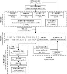
图2
技术路线"

表1
可见光植被指数①"
| 植被指数Vegetation indices(VIs) | 公式Formulation | 参考文献Reference |
| 归一化绿红差分指数 Normalized green-red difference index(NGRDI) | NGRDI=(G-R)/(G+R) | |
| 超绿指数Excess green index(EXG) | EXG=2g-r-b | |
| 植被颜色指数Color index of vegetation(CIVE) | CIVE=0.441r-0.881g+0.385b+18.787 45 | |
| 植被指数Vegetation index(VEG) | VEG=g/rab(1-a), a=0.667 | |
| 超绿超红差分指数 Excess green minus excess red index(EXGR) | EXGR=EXG-1.4r-g | |
| Woebbecke指数Woebbecke index(WI) | WI=(g-b)/(r-g) | |
| 联合指数Combination index(COM) | COM=0.25EXG+0.3EXGR+0.33CIVE+0.12VEG | |
| 联合指数2 Combination index 2(COM2) | COM2=0.36EXG+0.47CIVE+0.17VEG |
表2
试验方案信息"
| 试验Experiment | 特征Features |
| 1 | 光谱特征RGB |
| 2 | 光谱特征+DSM RGB+DSM |
| 3 | 光谱特征+植被指数RGB+VIs |
| 4 | 光谱特征+HSV RGB+HSV |
| 5 | 光谱特征+HSV纹理特征RGB+HSV_GLCM |
| 6 | 光谱特征+EMAPs RGB+EMAPs |
| 7 | 所有特征All features |
| 8 | 优化特征子集Optimized feature subset |
表3
DSM精度"
| 实测高度 Measured height/m | DSM/m | 误差Error/m |
| 290.019 | 289.957 | 0.062 |
| 293.550 | 293.540 | 0.010 |
| 293.385 | 293.333 | 0.050 |
| 290.029 | 289.957 | 0.072 |
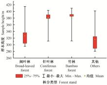
图3
林分样本高度分布"
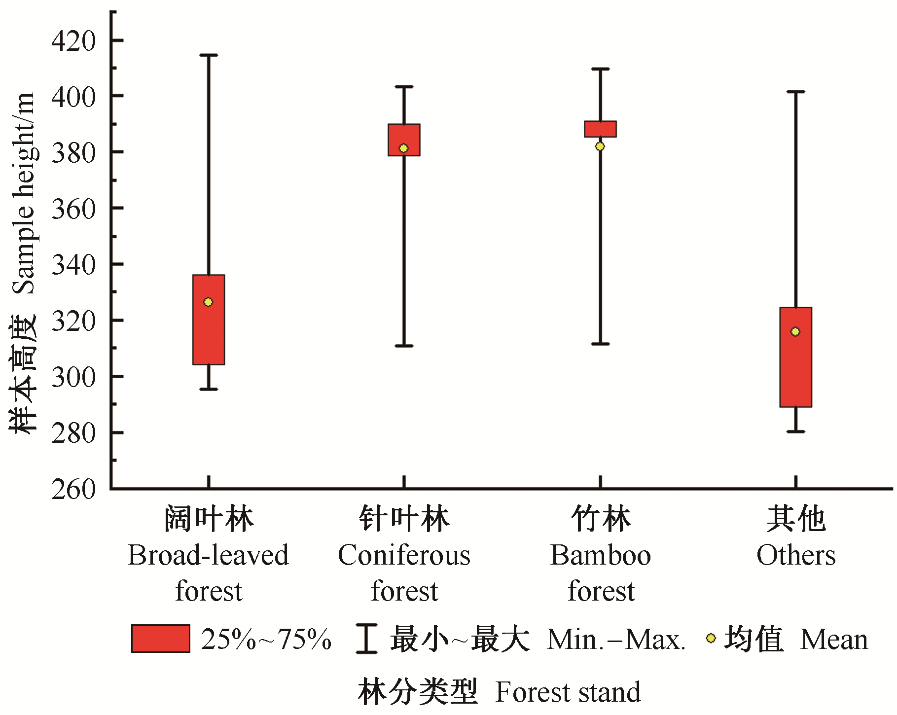
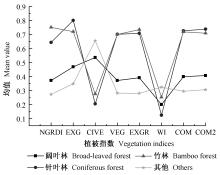
图4
各林分样本植被指数均值"
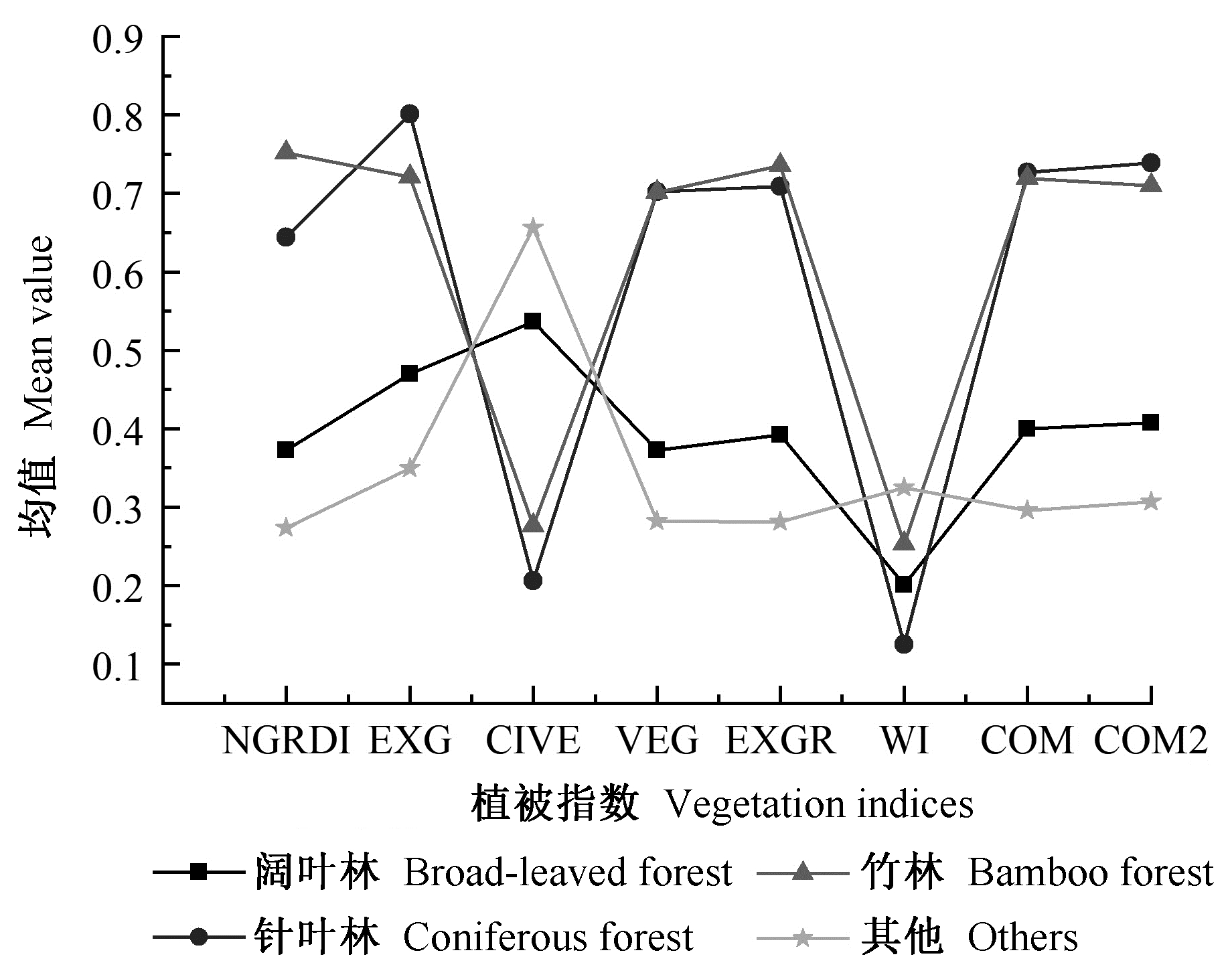
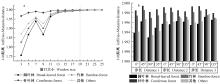
图5
样本平均可分性 a. 样本平均可分性随纹理尺度的变化Mean separability of samples with different scales texture;b. 不同步长和方向下样本的平均可分离度Mean separability of samples with different distances and directions."

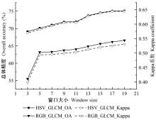
图6
不同窗口下HSV纹理与RGB纹理分类精度对比"


图7
采用递归特征消除随机森林算法的特征选择结果"
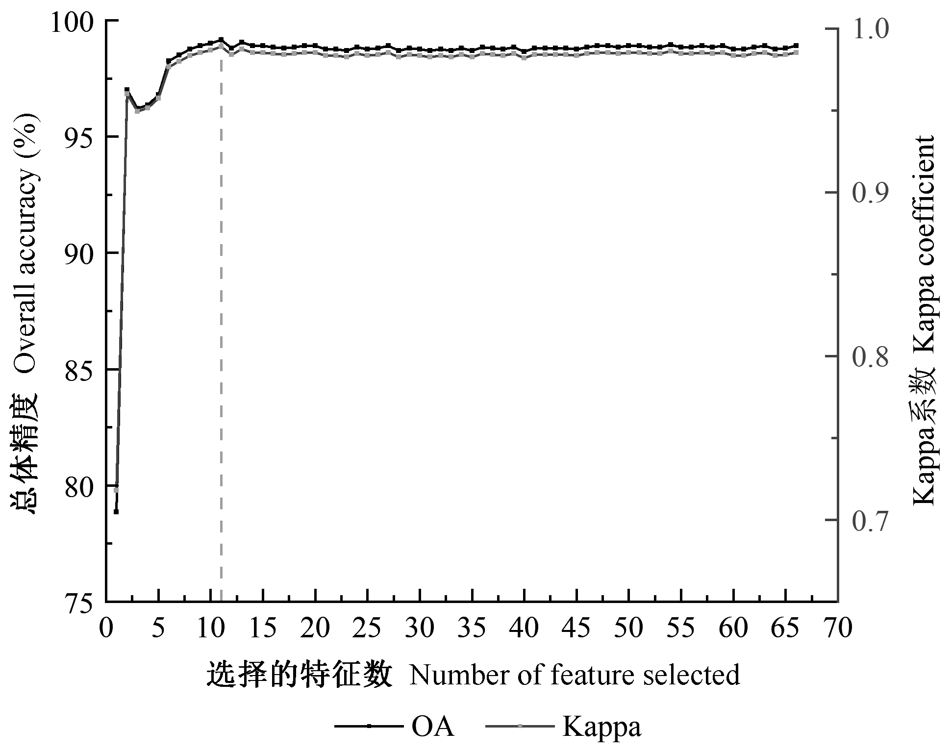
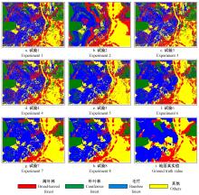
图8
不同试验分类结果"

表4
分类精度统计"
| 试验 Experiment | 精度 Accuracy | 阔叶林 Broad-leaved forest | 针叶林 Coniferous forest | 竹林 Bamboo forest | 其他 Others | 总体精度 OA(%) | Kappa系数 Kappa coefficient |
| 1 | PA(%) | 62.76 | 67.48 | 77.22 | 60.60 | 65.68 | 0.53 |
| UA(%) | 47.04 | 74.59 | 54.44 | 76.85 | |||
| F(%) | 53.77 | 70.86 | 63.86 | 67.86 | |||
| 2 | PA(%) | 71.37 | 62.82 | 56.07 | 77.61 | 66.40 | 0.54 |
| UA(%) | 44.74 | 43.13 | 79.04 | 88.42 | |||
| F(%) | 55.00 | 51.18 | 65.60 | 82.66 | |||
| 3 | PA(%) | 60.83 | 76.74 | 64.91 | 64.32 | 65.52 | 0.52 |
| UA(%) | 46.77 | 56.13 | 75.18 | 73.60 | |||
| F(%) | 52.88 | 64.84 | 69.67 | 68.65 | |||
| 4 | PA(%) | 61.61 | 76.91 | 66.91 | 63.58 | 66.21 | 0.53 |
| UA(%) | 47.82 | 55.86 | 75.09 | 75.40 | |||
| F(%) | 53.85 | 64.72 | 70.76 | 68.99 | |||
| 5 | PA(%) | 53.98 | 75.20 | 81.37 | 78.29 | 75.17 | 0.65 |
| UA(%) | 66.36 | 62.72 | 76.81 | 82.74 | |||
| F(%) | 59.53 | 68.40 | 79.02 | 80.45 | |||
| 6 | PA(%) | 65.55 | 80.29 | 78.37 | 76.49 | 75.92 | 0.66 |
| UA(%) | 61.21 | 61.20 | 81.23 | 86.14 | |||
| F(%) | 63.21 | 69.48 | 79.77 | 81.03 | |||
| 7 | PA(%) | 67.87 | 79.89 | 82.61 | 84.72 | 80.57 | 0.72 |
| UA(%) | 70.83 | 70.24 | 83.09 | 86.86 | |||
| F(%) | 69.32 | 74.75 | 82.85 | 85.78 | |||
| 8 | PA(%) | 69.20 | 73.02 | 83.26 | 87.36 | 81.05 | 0.73 |
| UA(%) | 70.13 | 72.99 | 85.11 | 84.63 | |||
| F(%) | 69.66 | 73.00 | 84.17 | 85.97 |
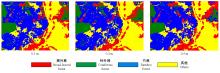
图9
不同分辨率影像分类结果"

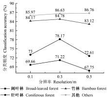
图10
不同分辨率影像各林分类型分类精度"

| 鲍蕊, 夏俊士, 薛朝辉, 等. 基于形态学属性剖面的高光谱影像集成分类. 遥感技术与应用, 2016, 31 (4): 731- 738. | |
| Bao R , Xia J S , Xue Z H , et al. Ensemble classification for hyperspectral imagery based on morphological attribute profiles. Remote Sensing Technology and Application, 2016, 31 (4): 731- 738. | |
|
戴建国, 张国顺, 郭鹏, 等. 基于无人机遥感可见光影像的北疆主要农作物分类方法. 农业工程学报, 2018, 34 (18): 122- 129.
doi: 10.11975/j.issn.1002-6819.2018.18.015 |
|
|
Dai J G , Zhang G S , Guo P , et al. Classification method of main crops in northern Xinjiang based on UAV visible waveband images. Transactions of the Chinese Society of Agricultural Engineering, 2018, 34 (18): 122- 129.
doi: 10.11975/j.issn.1002-6819.2018.18.015 |
|
| 范承啸, 韩俊, 熊志军, 等. 无人机遥感技术现状与应用. 测绘科学, 2009, 34 (5): 214- 215. | |
| Fan C X , Han J , Xiong Z J , et al. Application and status of unmanned aerial vehicle remote sensing technology. Science of Surveying and Mapping, 2009, 34 (5): 214- 215. | |
| 郭玉宝, 池天河, 彭玲, 等. 利用随机森林的高分一号遥感数据进行城市用地分类. 测绘通报, 2016, (5): 73- 76. | |
| Guo Y B , Chi T H , Peng L , et al. Classification of GF-1 remote sensing image based on random forests for urban land-use. Bulletin of Surveying and Mapping, 2016, (5): 73- 76. | |
| 井然, 邓磊, 赵文吉, 等. 基于可见光植被指数的面向对象湿地水生植被提取方法. 应用生态学报, 2016, 27 (5): 1427- 1436. | |
| Jing R , Deng L , Zhao W J , et al. Object-oriented aquatic vegetation extracting approach based on visible vegetation indices. Chinese Journal of Applied Ecology, 2016, 27 (5): 1427- 1436. | |
| 林志玮, 丁启禄, 黄嘉航, 等. 基于DenseNet的无人机光学图像树种分类研究. 遥感技术与应用, 2019, 34 (4): 704- 711. | |
| Lin Z W , Ding Q L , Huang J H , et al. Study on tree species classification of UAV optical image based on DenseNet. Remote Sensing Technology and Application, 2019, 34 (4): 704- 711. | |
| 刘友山, 吕成文, 祝凤霞, 等. 基于PCA和多尺度纹理特征提取的高分辨率遥感影像分类. 遥感技术与应用, 2012, 27 (5): 706- 711. | |
| Liu Y S , Lü C W , Zhu F X , et al. Extraction of high spatial resolution remote sensing image classification based on PCA and multi-scale texture feature. Remote Sensing Techology and Application, 2012, 27 (5): 706- 711. | |
|
刘云鹏, 巩睿, 解春霞, 等. 基于Landsat遥感影像的杨树信息提取方法分析. 江苏林业科技, 2017, 44 (2): 28- 33.
doi: 10.3969/j.issn.1001-7380.2017.02.007 |
|
|
Liu Y P , Gong R , Xie C X , et al. Study on information extraction of poplar resources using landsat remotely sensed datasets. Journal of Jiangsu Forestry Science & Technology, 2017, 44 (2): 28- 33.
doi: 10.3969/j.issn.1001-7380.2017.02.007 |
|
|
吕杰, 郝宁燕, 李崇贵, 等. 利用随机森林和纹理特征的森林类型识别. 遥感信息, 2017, 32 (6): 109- 114.
doi: 10.3969/j.issn.1000-3177.2017.06.018 |
|
|
Lü J , Hao N Y , Li C G , et al. Identification of forest type based on random forest and texture characteristics. Remote Sensing Information, 2017, 32 (6): 109- 114.
doi: 10.3969/j.issn.1000-3177.2017.06.018 |
|
| 马慧娟, 高小红, 谷晓天. 随机森林方法支持的复杂地形区土地利用/土地覆被分类研究. 地球信息科学学报, 2019, 21 (3): 359- 371. | |
| Ma H J , Gao X H , Gu X T . Random forest classification of Landsat 8 imagery for the complex terrain area based on the combination of spectral, topographic and texture information. Journal of Geo-Information Science, 2019, 21 (3): 359- 371. | |
| 马娜, 胡云锋, 庄大方, 等. 基于最佳波段指数和J-M距离可分性的高光谱数据最佳波段组合选取研究——以环境小卫星高光谱数据在东莞市的应用为例. 遥感技术与应用, 2010, 25 (3): 358- 365. | |
| Ma N , Hu Y F , Zhuang D F , et al. Determination on the optimum band combination of HJ-1A hyperspectral data in the case region of Dongguan based on optimum index factor and J-M distance. Remote Sensing Technology and Application, 2010, 25 (3): 358- 365. | |
| 裴欢, 孙天娇, 王晓妍. 基于Landsat 8 Oli影像纹理特征的面向对象土地利用/覆盖分类. 农业工程学报, 2018, 34 (2): 248- 255. | |
| Pei H , Sun T J , Wang X Y . Object-oriented land use/cover classification based on texture features of Landsat 8 Oli image. Transactions of the Chinese Society of Agricultural Engineering, 2018, 34 (2): 248- 255. | |
| 任芯雨. 2016. 考虑植被季相节律的高分辨率遥感影像城市森林分类. 南京: 南京林业大学硕士学位论文. | |
| Ren X Y. 2016. Urban forest vegetation classification in consideration of vegetation phenolpgy based on high spatial resolution on satellite imagery. Nanjing: MS thesis of Nanjing Forestry University. [in Chinese] | |
| 史忠奎, 李培军, 罗伦, 等. 基于形态学属性剖面和单类随机森林分类的道路路域新增建筑物提取方法. 北京大学学报: 自然科学版, 2018, 54 (1): 105- 114. | |
| Shi Z K , Li P J , Luo L , et al. A method for extraction of newly-built buildings in road region using morphological attribute profiles and one-class random forest. Acta Scientiarum Naturalium Universitatis Pekinensis, 2018, 54 (1): 105- 114. | |
| 宋荣杰, 宁纪锋, 常庆瑞, 等. 基于小波纹理和随机森林的猕猴桃果园遥感提取. 农业机械学报, 2018, 49 (4): 222- 231. | |
| Song R J , Ning J F , Chang Q R , et al. Kiwifruit orchard mapping based on wavelet textures and random forest. Transactions of the Chinese Society of Agricultural Machinery, 2018, 49 (4): 222- 231. | |
| 宋荣杰, 宁纪锋, 刘秀英, 等. 基于纹理特征和SVM的QuickBird影像苹果园提取. 农业机械学报, 2017, 48 (3): 188- 197. | |
| Song R J , Nimg J F , Liu X Y , et al. Apple orchard extraction with QuickBird imagery based on texture features and support vector machine. Transactions of the Chinese Society of Agricultural Machinery, 2017, 48 (3): 188- 197. | |
| 王娜, 李强子, 杜鑫, 等. 单变量特征选择的苏北地区主要农作物遥感识别. 遥感学报, 2017, 21 (4): 519- 530. | |
| Wang N , Li Q Z , Du X , et al. Identification of main crops based on the univariate feature selection in Subei. Journal of Remote Sensing, 2017, 21 (4): 519- 530. | |
|
温小乐, 钟奥, 胡秀娟. 基于随机森林特征选择的城市绿化乔木树种分类. 地球信息科学学报, 2018, 20 (12): 1777- 1786.
doi: 10.12082/dqxxkx.2018.180310 |
|
|
Wen X L , Zhong A , Hu X J . The classification of urban greening tree species based on feature selection of random. Journal of Geo-Information Science, 2018, 20 (12): 1777- 1786.
doi: 10.12082/dqxxkx.2018.180310 |
|
| 杨珺雯, 张锦水, 朱秀芳, 等. 随机森林在高光谱遥感数据中降维与分类的应用. 北京师范大学学报: 自然科学版, 2015, 51 (S1): 82- 88. | |
| Yang J W , Zhang J S , Zhu X F , et al. Random forest applied for dimension reduction and classification in hyperspectral data. Journal of Beijing Normal University: Natural Science, 2015, 51 (S1): 82- 88. | |
| 尹凌宇, 覃先林, 孙桂芬, 等. 基于高分二号多光谱数据的树种识别方法. 林业资源管理, 2016, (4): 121- 127. | |
| Yin L Y , Qin X L , Sun G F , et al. Tree species identification method based on GF-2 images. Forest Resources Management, 2016, (4): 121- 127. | |
| 张磊, 宫兆宁, 王启为, 等. Sentinel-2影像多特征优选的黄河三角洲湿地信息提取. 遥感学报, 2019, 23 (2): 313- 326. | |
| Zhang L , Gong Z N , Wang Q W , et al. Wetland mapping of yellow river delta wetlands based on multi-feature optimization of Sentinel-2 images. Journal of Remote Sensing, 2019, 23 (2): 313- 326. | |
|
Brovkina O , Cienciala E , Surový P , et al. Unmanned aerial vehicles (UAV) for assessment of qualitative classification of Norway spruce in temperate forest stands. Geo-Spatial Information Science, 2018, 21 (1): 12- 20.
doi: 10.1080/10095020.2017.1416994 |
|
|
Cheng K , Wang J . Forest type classification based on integrated spectral-spatial-temporal features and random forest algorithm-a case study in the Qinling Mountains. Forests, 2019, 10 (7): 559- 577.
doi: 10.3390/f10070559 |
|
|
Cross M , Scambos T , Pacifici F , et al. Classification of tropical forest tree species using meter-scale image data. Remote Sensing, 2019, 11 (12): 1411- 1159.
doi: 10.3390/rs11121411 |
|
| Mura M D , Benediktsson J A , Waske B , et al. Morphological attribute profiles for the analysis of very high resolution images. IEEE Transactions on Geoscience and Remote Sensing, 2010, 48 (10): 3747- 3762. | |
| David L C G, Ballado A H. 2016. Vegetation indices and textures in object-based weed detection from UAV imagery. Proceedings of the 6th IEEE International Conference on Control System, Computing and Engineering, Penang, Malaysia. | |
| Fassnacht F E , Latifi H , Stereńczak K , et al. Review of studies on tree species classification from remotely sensed data. Remote Sensing of Environment, 2016, 186 (214): 64- 87. | |
| Ghamisi P , Benediktsson J A , Cavallaro G , et al. Automatic framework for spectral-spatial classification based on supervised feature extraction and morphological attribute profiles. IEEE Journal of Selected Topics in Applied Earth Observations and Remote Sensing, 2014, 7 (6): 2147- 2160. | |
| Gini R , Sona G , Ronchetti G , et al. Improving tree species classification using UAS multispectral images and texture measures. ISPRS International Journal of Geo-Information, 2018, 7 (8): 315- 333. | |
| Gini R , Passoni R , Pinto L , et al. Use of unmanned aerial systems for multispectral survey and tree classification: a test in a park area of northern Italy. European Journal of Remote Sensing, 2014, 47 (1): 251- 269. | |
| Gitelson A A , Kaufman Y J , Stark R , et al. Novel algorithms for remote estimation of vegetation fraction. Remote Sensing of Environment, 2002, 80 (1): 76- 87. | |
| Guerrero J M , Pajares G , Montalvo M , et al. Support vector machines for crop/weeds identification in maize fields. Expert Systems with Applications, 2012, 39 (12): 11149- 11155. | |
| Guijarro M , Pajares G , Riomoros I , et al. Automatic segmentation of relevant textures in agricultural images. Computers and Electronics in Agriculture, 2011, 75 (1): 75- 83. | |
| Hague T , Tillett N D , Wheeler H . Automated crop and weed monitoring in widely spaced cereals. Precision Agriculture, 2006, 7 (1): 21- 32. | |
| Haralick R M, Shanmugam K, Dinstein I. 1973. Textural features for image classification. IEEE Transactions on Systems, Man & Cybernetics, SMC-3(6): 610-621. | |
| Kataoka T, Kaneko T, Okamoto H, et al. 2003. Crop growth estimation system using machine vision. IEEE/ASME International Conference on Advanced Intelligent Mechatronics. | |
| Marpu P R , Pedergnana M , Mura M D , et al. Automatic generation of standard deviation attribute profiles for spectral-spatial classification of remote sensing data. IEEE Geoscience and Remote Sensing Letters, 2013, 10 (2): 293- 297. | |
| Maschler J , Atzberger C , Immitzer M . Individual tree crown segmentation and classification of 13 tree species using airborne hyperspectral data. Remote Sensing, 2018, 10 (8): 1218- 1247. | |
| Michez A , Piégay H , Jonathan L , et al. Mapping of riparian invasive species with supervised classification of unmanned aerial system (UAS) imagery. International Journal of Applied Earth Observation and Geoinformation, 2016, 44, 88- 94. | |
| Neto J C. 2004. A combined statistical-soft computing approach for classification and mapping weed species in minimum-tillage systems. University of Nebraska-Lincoln. | |
| Samiappan S , Turnage G , Hathcock L A , et al. Mapping of invasive phragmites (Common Reed) in Gulf of Mexico Coastal wetlands using multispectral imagery and small unmanned aerial systems. International Journal of Remote Sensing, 2017, 38 (8/10): 2861- 2882. | |
| Sothe C , Dalponte M , Almeida C M D , et al. Tree species classification in a highly diverse subtropical forest integrating UAV-based photogrammetric point cloud and hyperspectral data. Remote Sensing, 2019, 11 (11): 1338- 1362. | |
| Woebbecke D M . Color indices for weed identification under various soil, residue, and lighting conditions. Transactions of the ASAE, 1995, 38 (1): 259- 269. | |
| Xie Z , Chen Y , Lu D , et al. Classification of land cover, forest, and tree species classes with Ziyuan-3 multispectral and stereo data. Remote Sensing, 2019, 11 (2): 164- 191. | |
| Yu X , Hyyppä J , Litkey P , et al. Single-sensor solution to tree species classification using multispectral airborne laser scanning. Remote Sensing, 2017, 9 (2): 108- 124. | |
| Zhang A , Sun G , Ma P , et al. Coastal wetland mapping with Sentinel-2 MSI imagery based on gravitational optimized multilayer perceptron and morphological attribute profiles. Remote Sensing, 2019, 11 (8): 952- 975. |
| [1] | 武星煜, 辛恒, 杨启青, 陈尚花, 王汉男, 魏美才. 危害青海云杉的新松叶蜂属(膜翅目:松叶蜂科)一新种[J]. 林业科学, 2021, 57(6): 111-114. |
| [2] | 陆海飞,刘望舒,徐建民,李光友,范春节,梁国坚,张磊. 广西中南部尾巨桉人工林立地类型划分及立地质量评价[J]. 林业科学, 2021, 57(5): 13-24. |
| [3] | 周焱,刘文萍,骆有庆,宗世祥. 基于深度学习的小目标受灾树木检测方法[J]. 林业科学, 2021, 57(3): 98-107. |
| [4] | 黄承玲,姚刚,田晓玲,任永权,黄家湧,马永鹏. 基于RAD高通量测序的贵州百里杜鹃保护区杜鹃花属分类[J]. 林业科学, 2021, 57(2): 72-81. |
| [5] | 宗学政,田晓瑞. 可燃物处理对大兴安岭地区主要林型火行为的影响[J]. 林业科学, 2021, 57(2): 139-149. |
| [6] | 王雪峰,陈珠琳,管青军,刘嘉政,王甜,袁莹. 基于林内图像的单位面积碳储量估计方法[J]. 林业科学, 2021, 57(1): 105-112. |
| [7] | 陈模舜,金则新,柯世省,陈子林,潘德月. 极濒危物种天台鹅耳枥群落特征及其与环境因子的关系[J]. 林业科学, 2020, 56(9): 1-11. |
| [8] | 巫娟,胡姝珍,茅思雨,邹凯,郑淇元,邱啟璜,施建敏. 基于叶片形态的毛竹单叶叶面积模型[J]. 林业科学, 2020, 56(8): 47-54. |
| [9] | 林达坤,黄世国,张飞萍,梁光红,吴松青,胡霞,王荣. 基于改进差分进化算法的鳞翅目昆虫图像识别方法[J]. 林业科学, 2020, 56(3): 73-81. |
| [10] | 赵霖,张晓丽,吴艳双,张斌. 面向机载高光谱数据的3D-CNN亚热带森林树种分类[J]. 林业科学, 2020, 56(11): 97-107. |
| [11] | 栗旭升,李虎,陈冬花,刘玉锋,刘赛赛,刘聪芳,胡国庆. 联合GF-5与GF-6卫星数据的多分类器组合亚热带树种识别[J]. 林业科学, 2020, 56(10): 93-104. |
| [12] | 李亚东,曹明兰,李长青,冯仲科. 基于POS约束的无人机森林航摄影像分区匹配策略[J]. 林业科学, 2020, 56(10): 113-120. |
| [13] | 崔博超,郑江华,刘忠军,马涛,沈江龙,赵雪迷. 无人机遥感影像的YOLOv3鼠洞识别技术[J]. 林业科学, 2020, 56(10): 199-208. |
| [14] | 吴项乾,曹林,申鑫,汪贵斌,曹福亮. 基于无人机激光雷达的银杏人工林有效叶面积指数估测[J]. 林业科学, 2020, 56(1): 74-86. |
| [15] | 王卫, 杨俊杰, 罗晓莹, 周长江, 陈世发, 杨志军, 侯荣丰, 陈再雄, 李永生. 基于Maxent模型的丹霞山国家级自然保护区极小种群植物丹霞梧桐的潜在生境评价[J]. 林业科学, 2019, 55(8): 19-27. |
| 阅读次数 | ||||||
|
全文 |
|
|||||
|
摘要 |
|
|||||