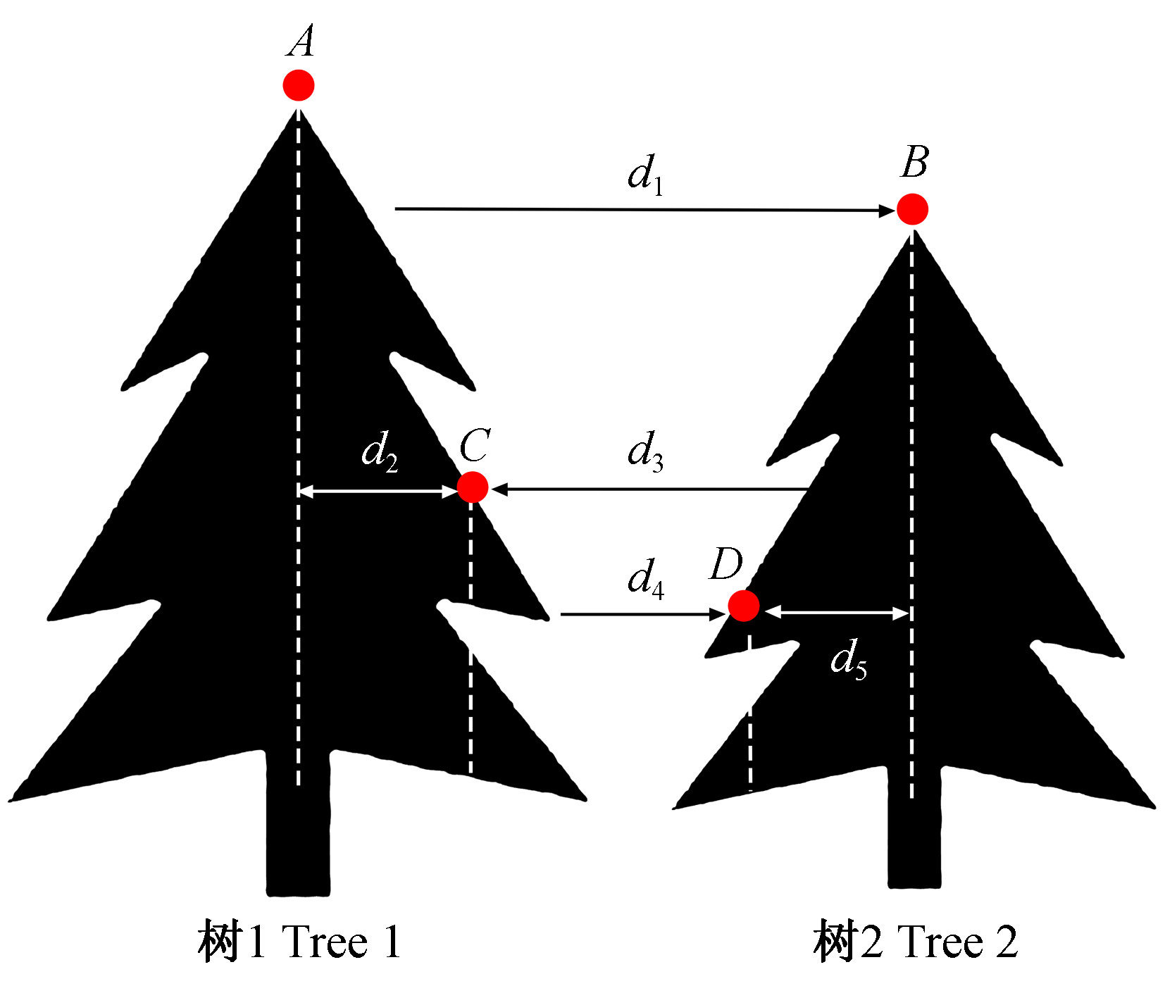
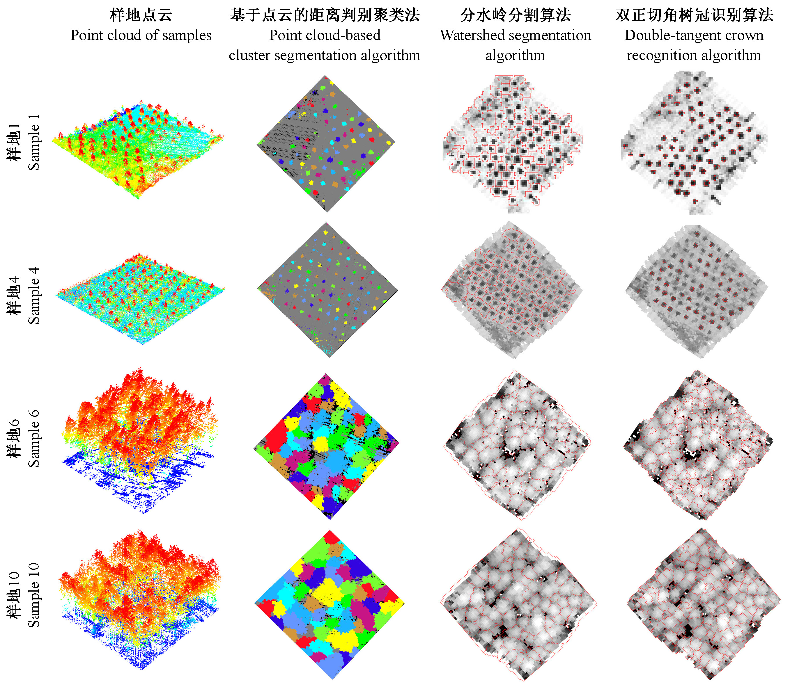
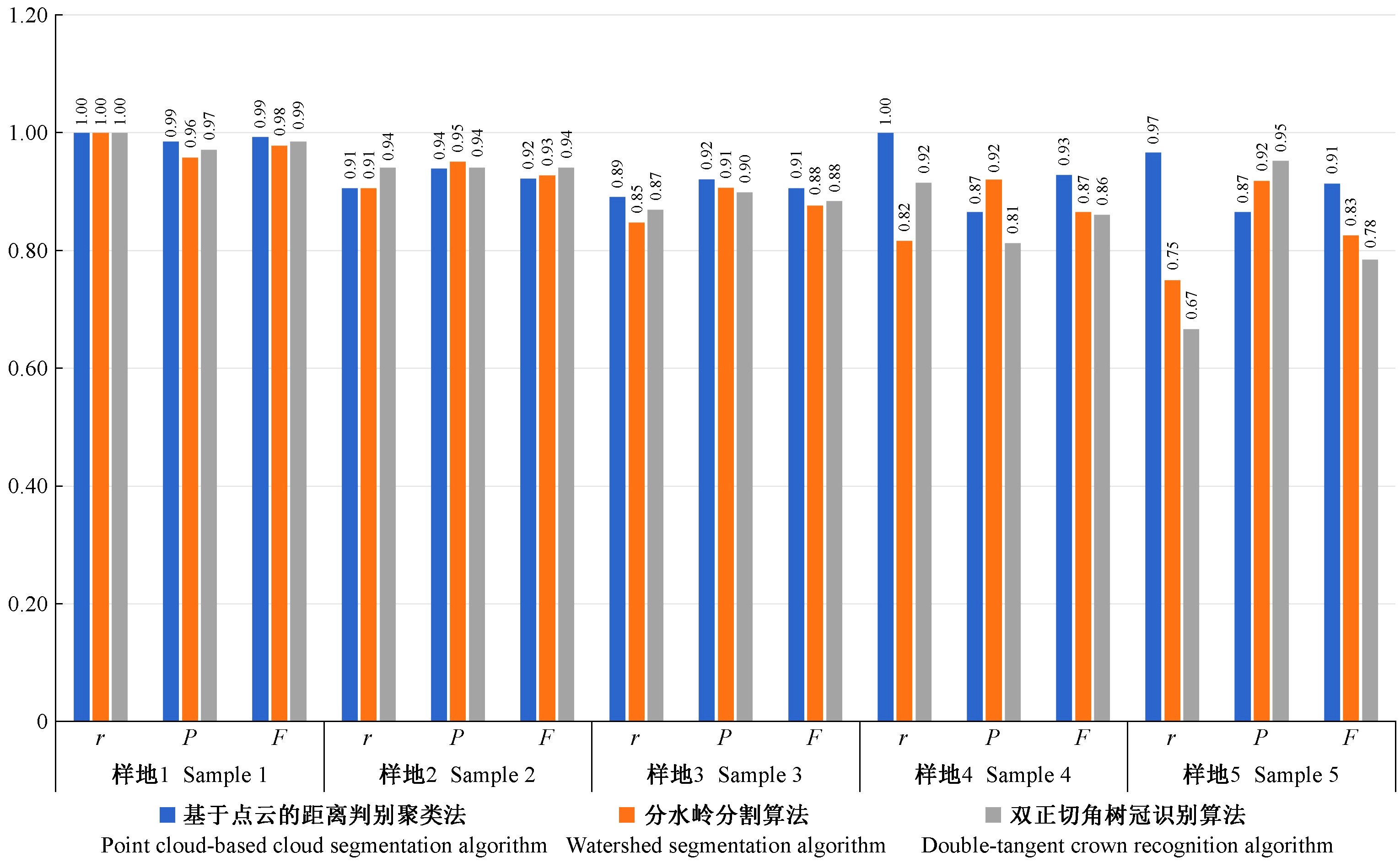
|
胡凯龙, 刘清旺, 庞勇, 等. 基于机载激光雷达校正的ICESat/GLAS数据森林冠层高度估测. 农业工程学报, 2017, 33 (16): 88- 95.
|
|
Hu K L , Liu Q W , Pang Y , et al. Forest canopy height estimation based on ICESat/GLAS data by airborne LiDAR. Transactions of the Chinese Society of Agricultural Engineering, 2017, 33 (16): 88- 95.
|
|
霍朗宁, 张晓丽. 基于机载LiDAR点云多层聚类的单木信息提取及其精度评价. 林业科学, 2021, 57 (1): 85- 94.
|
|
Huo L N , Zhang X L . Individual tree information extraction and accuracy evaluation based on airborne LiDAR point cloud by multilayer clustering method. Scientia Silvae Sinicae, 2021, 57 (1): 85- 94.
|
|
李平昊, 申鑫, 代劲松, 等. 机载激光雷达人工林单木分割方法比较和精度分析. 林业科学, 2018, 54 (12): 127- 136.
|
|
Li P H , Shen X , Dai J S , et al. Comparisons and accuracy assessments of LiDAR-based tree segmentation approaches in planted forests. Scientia Silvae Sinicae, 2018, 54 (12): 127- 136.
|
|
刘国华, 傅伯杰, 方精云. 中国森林碳动态及其对全球碳平衡的贡献. 生态学报, 2000, 20 (5): 733- 740.
|
|
Liu G H , Fu B J , Fang J Y . Carbon dynamics of Chinese forests and its contribution to global carbon balance. Acta Ecologica Sinica, 2000, 20 (5): 733- 740.
|
|
刘清旺, 李世明, 李增元, 等. 无人机激光雷达与摄影测量林业应用研究进展. 林业科学, 2017, 53 (7): 134- 148.
|
|
Liu Q W , Li S M , Li Z Y , et al. Review on the applications of UAV-based LiDAR and photogrammetry in forestry. Scientia Silvae Sinicae, 2017, 53 (7): 134- 148.
|
|
刘清旺, 李增元, 陈尔学, 等. 利用机载激光雷达数据提取单株木树高和树冠. 北京林业大学学报, 2008, 30 (6): 83- 89.
|
|
Liu Q W , Li Z Y , Chen E X , et al. Extracting height and crown of individual tree using airborne LiDAR data. Journal of Beijing Forestry University, 2008, 30 (6): 83- 89.
|
|
申鑫, 曹林, 佘光辉. 高光谱与高空间分辨率遥感数据的亚热带森林生物量反演. 遥感学报, 2016, 20 (6): 1446- 1460.
|
|
Shen X , Cao L , She G H . Subtropical forest biomass estimation based on hyperspectral and high-resolution remotely sensed data. Journal of Remote Sensing, 2016, 20 (6): 1446- 1460.
|
|
吴项乾, 曹林, 申鑫, 等. 基于无人机激光雷达的银杏人工林有效叶面积指数估测. 林业科学, 2020, 56 (1): 74- 86.
|
|
Wu X Q , Cao L , Shen X , et al. Estimation of effective leaf area index using UAV-based LiDAR in Ginkgo plantations. Scientia Silvae Sinicae, 2020, 56 (1): 74- 86.
|
|
王瑞瑞, 李怡燃, 石伟, 等. 基于LiDAR数据的单木提取算法研究. 西北林学院学报, 2021, 36 (3): 182- 189.
|
|
Wang R R , Li Y R , Shi W , et al. Single wood extraction algorithm based on LiDAR data. Journal of Northwest Forestry University, 2021, 36 (3): 182- 189.
|
|
王轶夫, 岳天祥, 赵明伟, 等. 机载LiDAR数据的树高识别算法与应用分析. 地球信息科学学报, 2014, 16 (6): 958- 963.
|
|
Wang Y F , Yue T X , Zhao M W , et al. Study of factors impacting the tree height extraction based on airborne LiDAR data. Journal of Geo-Information Science, 2014, 16 (6): 958- 963.
|
|
杨秋丽. 2018. 机载LiDAR单木分割方法对比及其影响因素分析. 乌鲁木齐: 新疆大学.
|
|
Yang Q L. 2018. Comparison of airborne LiDAR individual tree segmentation methods and analysis of influencing factors. Urumqi: Xinjiang University. [in Chinese]
|
|
赵峰, 庞勇, 李增元, 等. 机载激光雷达和航空数码影像单木树高提取. 林业科学, 2009, 45 (10): 81- 87.
|
|
Zhao F , Pang Y , Li Z Y , et al. Extraction of individual tree height using a combination of aerial digital camera imagery and LiDAR. Scientia Silvae Sinicae, 2009, 45 (10): 81- 87.
|
|
Alexander C . Delineating tree crowns from airborne laser scanning point cloud data using Delaunay triangulation. International Journal of Remote Sensing, 2009, 30 (14): 3843- 3848.
|
|
Ayrey E , Fraver S , Kershaw J A , et al. Layer stacking: a novel algorithm for individual forest tree segmentation from LiDAR point clouds. Canadian Journal of Remote Sensing, 2017, 43 (1): 16- 27.
|
|
Chen Q , Baldocchi D , Gong P , et al. Isolating individual trees in a savanna woodland using small footprint LiDAR data. Photogrammetric Engineering & Remote Sensing, 2006, 72 (8): 923- 932.
|
|
Duncanson L I , Cook B D , Hurtt G C , et al. An efficient, multi-layered crown delineation algorithm for mapping individual tree structure across multiple ecosystems. Remote Sensing of Environment, 2014, 154, 378- 386.
|
|
Eysn J , Hollaus M , Lindberg E , et al. A benchmark of LiDAR-based single tree detection methods using heterogeneous forest data from the alpine space. Forests, 2015, 6 (12): 1721- 1747.
|
|
Guo Q , Li W , Yu H . Effects of topographic variability and LiDAR sampling density on several DEM interpolation methods. Photogrammetric Engineering & Remote Sensing, 2010, 76 (6): 701- 712.
|
|
Guo Q H , Yan J , Zhao X Q , et al. Improved progressive TIN densification filtering algorithm for airborne LiDAR data in forested areas. ISPRS Journal of Photogrammetry and Remote Sensing, 2016, 117, 79- 91.
|
|
Hosoi F , Matsugami H , Watanuki K , et al. Accurate detection of tree apexes in coniferous canopies from airborne scanning light detection and ranging images based on crown-extraction filtering. Journal of Applied Remote Sensing, 2012, 6 (1): 063502-1- 063502-13.
|
|
Jennings S , Brown N , Sheil D . Assessing forest canopies and understorey illumination: canopy closure, canopy cover and other measures. Forestry: An International Journal of Forest Research, 1999, 72 (1): 59- 74.
|
|
Kaartinen H , Hyyppä J , Yu X W , et al. An international comparison of individual tree detection and extraction using airborne laser scanning. Remote Sensing, 2012, 4 (4): 950- 974.
|
|
Korhonen L , Korpela I , Heiskanen J , et al. Airborne discrete-return LiDAR data in the estimation of vertical canopy cover, angular canopy closure and leaf area index. Remote Sensing of Environment, 2011, 115 (4): 1065- 1080.
|
|
Lee A C , Lucas R M . A LiDAR-derived canopy density model for tree stem and crown mapping in Australian forests. Remote Sensing of Environment, 2007, 111 (4): 493- 518.
|
|
Li W , Guo Q , Jakubowski M K , et al. A new method for segmenting individual trees from the LiDAR point cloud. Photogrammetric Engineering & Remote Sensing, 2012, 78 (1): 75- 84.
|
|
Liu Q W , Fu L Y , Wang G , et al. Improving estimation of forest canopy cover by introducing loss ratio of laser pulses using airborne LiDAR. IEEE Transactions on Geoscience and Remote Sensing, 2019, 99, 1- 19.
|
|
Mei C , Durrieu S . Tree crown delineation from digital elevation models and high resolution imagery. Proc. IAPRS, 2004, 36, 218- 223.
|
|
Parent J R , Volin J C . Assessing the potential for leaf-off LiDAR data to model canopy closure in temperate deciduous forests. ISPRS Journal of Photogrammetry and Remote Sensing, 2014, 95, 134- 145.
|
|
Paris C , Valduga D , Bruzzone L . A hierarchical approach to three-dimensional segmentation of LiDAR data at single-tree level in a multilayered forest. IEEE Transactions on Geoscience and Remote Sensing, 2016, 54 (7): 4190- 4203.
|
|
Pedersen R Ø , Bollandsås O M , Gobakken T , et al. Deriving individual tree competition indices from airborne laser scanning. Forest Ecology and Management, 2012, 280, 150- 165.
|
|
Pitkanen J . Individual tree detection in digital aerial images by combining locally adaptive binarization and local maxima methods. Canadian Journal of Forest Research, 2001, 31 (5): 832- 844.
|
|
Reitberger J , Schnörr C , Krzystek P , et al. 3D segmentation of single trees exploiting full waveform LiDAR data. ISPRS Journal of Photogrammetry and Remote Sensing, 2009, 64 (6): 561- 574.
|
|
Yao W , Krull J , Krzystek P , et al. Sensitivity analysis of 3D individual tree detection from LiDAR point clouds of temperate forests. Forests, 2014, 5, 1122- 1142.
|
|
Zhang C , Zhou Y , Qiu F . Individual tree segmentation from LiDAR point clouds for urban forest inventory. Remote Sensing, 2015, 7 (6): 7892- 7913.
|
|
Zhao K , Popescu S , Nelson R . LiDAR remote sensing of forest biomass: a scale-invariant estimation approach using airborne lasers. Remote Sensing of Environment, 2009, 113 (1): 182- 191.
|